AP HUMAN GEOGRAPHY Unit 7: POLITICAL GEOGRAPHY (Ch.8)
|
|
|
- Marilyn Hampton
- 6 years ago
- Views:
Transcription


1 AP HUMAN GEOGRAPHY Unit 7: POLITICAL GEOGRAPHY (Ch.8)
2 Political Geography The study of human political organization of the earth. Study political organization at three scales: Supranational (Organizations that transcends national boundaries) National (country) Subnational (states/local)

3 State Politically organized territory (permanent population, economy), (sovereign) government, recognized by international community. State = Country state = sub-state


4 Politically Organized/Working Economy Permanent Population State Defined Territory Recognized by other States State = Country state = sub-state
5

6 NOT A STATE The term State refers to a country and NOT a political subdivision with the United States, such as Oregon Most countries with a federal constitution are made up of states. Ex. U.S, Mexico, Canada, Germany
7 Sovereignty A recognized right to control a territory both politically and militarily Under international law, States are sovereign.
8


9 Microstate A very small State EX: Singapore, Vatican City, San Marino

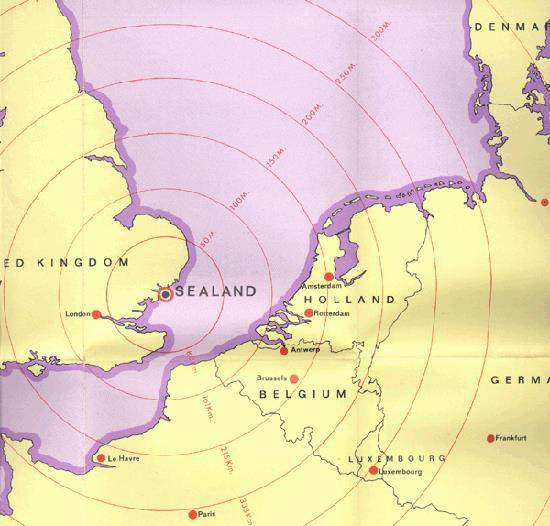
10 Is Sealand a State?
11
12
13 Nation A group of people who think of themselves as one based on a shared culture and history. May share religion, language, an ethnicity, etc. Ex. Palestinians, Kurds, Armenians in Turkey


14 Culturally Defined Shared Culture Nation Not defined by territory A I agi ed Co u ity
15 The French Nations Native Americans
16 Italy Nations? Great Britain
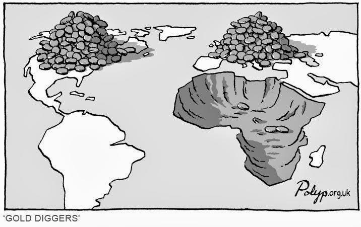
17 Italy Not Nations Great Britain
18 Multinational State A State that contains more than one nation within its borders Examples: USA, Canada, Belgium, Iraq(Sunni vs. Shiite)
19 Nation-State A politically organized area in which a nation and State occupy the same space. An ATTEMPT to marry the concepts of nation and State into one big happy territory. Ex. Japan, Ireland, Israel, Turkey, France, Iran, Ukraine, Belarus TWO Benefits/Problems of a Nation-State?

20 Stateless Nation When a nation does not have a territory to call its own Examples Assyrian Christians of Iraq Kurds in the Middle East Uyghurs in Western China


21 Multinational State Multistate Nations Stateless Nations A state with more than one nation inside its borders. Many States in the world is a multinational state. Iraq: Sunnis, Kurds, Shiites A nation that stretches across borders. EX: North/South Korea A nation that does not have a state. Palestinians, Kurds

22 Question 1 Explain the Peace of Westphalia and its significance. How did the treaties fundamentally change society? Describe the problems with a multinational state and stateless nation.
23 Collect Country Profile (South Africa)
24 COLONIALISM A STORY ABOUT STUFF or How to steal stuff from other territories and make yourself filthy rich.
25
26 Colonialism Establishing a new territory by a group of people who keep their ties to their home government. The control of one State over another place Often the colonizer has a more industrialized economy Major factor in colonialism was the Industrial Revolution
27 Colonialism Age of European Colonialism lasted from 15th century until end of WWII (1945) Two Major Periods First occurred after European explorers discovered land in the Western Hemisphere (15th century) Second Late 1800 s when western Euro powers competed to carve up Africa * France and England would control 70% of Africa
28 Berlin Conference (1884): Called together all the European powers to lay down rules for the division of Africa. Agreed that any European power could claim land in Africa by notifying other nations of their claims and showing they could control the area. What are THREE benefits of colonizing African land for Europe?

29 Scramble for Africa: Period between 1880 and 1914 when European countries competed to claim territory in Africa. Spain France Holland Great Britain Germany Italy Portugal Belgium
30
31

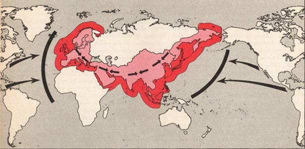
32 Mercantilism An economic system where a State acquires colonies for raw materials to ship back home and use them in making products for the mother country.
33 Imperialism The process of establishing political, social and economic dominance over a colonized area. Ex. Europeans acculturated indigenous peoples to European Christianity, architecture, and culture
34 European Motives for Imperialism
35 Motive #1 - Industry To improve their economies they needed new markets (customers) and raw materials.
36 Motive #2 - Nationalism Pride in one s country led to a heated competition among the European nations. The more lands you controlled showed how strong you were as a country.
37 Motive #3 - Racism and Social Darwinism Social Darwinism : Idea that one race is better than another Survival of the fittest: Those who are the fittest would enjoy wealth and success. If others suffered or were exterminated that was nature.
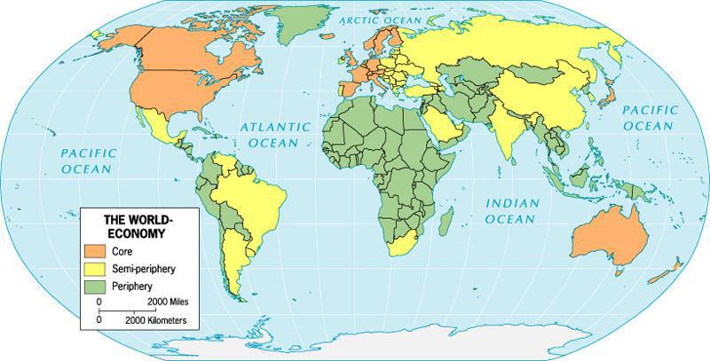
38 Motive #4 - Civilizing Mission Missionaries wanted to Christianize and civilize the peoples of noneuropeans societies.
39 Question 2 Discuss the concept of Colonialism. Explain how European colonialism diffused the nation-state model. Explain consequences of this colonialism on the contemporary political map and use Figure 8.8 in your discussion.
40

41 Dependency Theory Asserts that former colonies in South America, Africa, and Asia are still poor because of colonization When colonizers left, the populations in those States were not unified and has led to conflicts Colonial subjects still trade with former colonial rulers. Ex. Senegal and France
42 Dependency Theory Example: Brazil has a rapidly growing economy that is nonetheless still entangled in its dependency with foreign nations. Long colonized by the Portuguese, Brazil continues to export most of its raw materials and agricultural production. Many Brazilians continue to live in poverty and are malnourished.

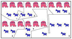
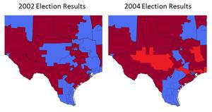
43 Neocolonialism The continued economic dependence of new States on their former colonial masters Ex. Commonwealth of Nations countries are being economically pressured to cooperate with the United Kingdom.
44
45 Question 3 Define capitalism and explain the concept of a globalized economic order. Give examples from Figure 8.10 of this economic order of the World Economy.
46 3 Beliefs of World Systems Theory 1. The world economy has one market and a global division of labor 2. The world has multiple States, but everything takes place in the world economy 3. The world economy has a three tier structure. A tier is country where particular economic processes take place

47 Three-Tiered System Core: Higher levels of education, salaries, and more technology. Generates a lot of wealth. Sell finished goods EX: Western Europe Semi-periphery: places where core and periphery processes take place. Countries exploited by the core, but then exploits the periphery. Production EX: Eastern Europe Periphery: lower education, low salaries, and less technology. Marginal position in world economy. Natural Resources Extracted EX: Southwest Asia
48
49 Question 4 Define and explain unitary government. Define and explain the federal system. Explain how a federal system accommodates regional interests.


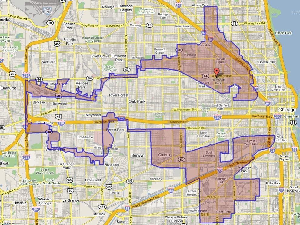
50 Gerrymandering Redrawing electoral districts to create an advantage for one political party A Consensus happens every 10 years to reapportion House of Representatives Consequences: Strengthen/weakens power of a political power. Divides districts to give one party a majority in most districts. Districts could be represented by someone who lives far away/ different than them
51 Explain the TWO different types of Gerrymandering discussed in the Video. DBgYodIE
52
53
54
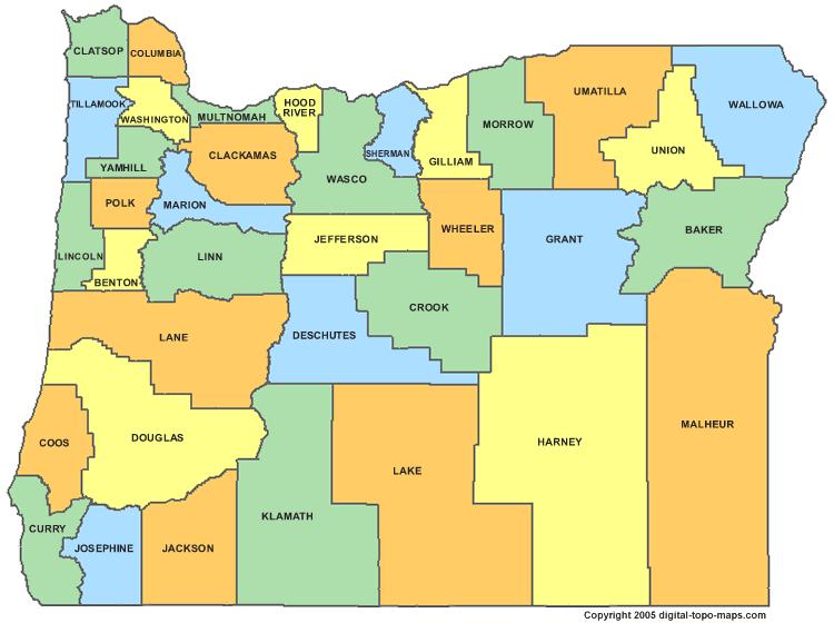
55 What are the criteria for drawing district lines? The criteria for consideration by the Legislative Assembly or the Secretary of State for redistricting legislative and congressional districts are listed in ORS The criteria require that each district, as nearly as practicable, shall: Be contiguous; Be of equal population; Utilize existing geographic or political boundaries; Not divide communities of common interest; and Be connected by transportation links.
56
57
58 Governmental Structures
59 Democracy The idea that the people are the ultimate sovereign The people are the nation and have ultimate power over what happens in the State There are currently 123 democracies in the world.
60 Autocracy A country that is run according to the interests of the ruler rather than the people. EX: Cuba, Syria, Saudi Arabia, United Arab Emirates, Iran, Uzbekistan, China, North Korea, Laos, and Vietnam.
61 Centripetal The forces within a State that unify the people

62 Nationalism Flags, Symbols, Holidays Communicati on Centripetal Forces Schools and Education Transportat ion Church and Religion
63 Centrifugal Forces within a State that divide the people.

64 Opposing Institutions Economic Forces Oppositional Nationalism Centrifugal Forces Separatist Movements Ethnic Forces Peripheral Locations

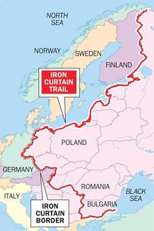
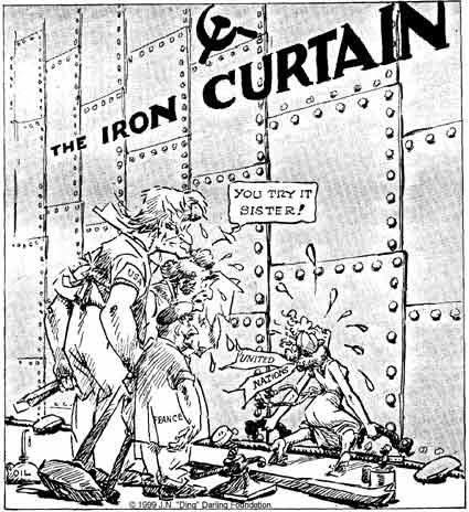
65 Balkanization The process of fragmentation or division of a region or State into smaller regions. Ex. Balkan region of Eastern Europe now composed of smaller States
66 Ethnonationalism A powerful emotional attachment to one s nation. This occurs when a minority nation (ethnic group) within a State feels different from the rest of the State s people. Ex. Palestinian ethnonationalism in Israel
67 Related Ethnonationalism Conflicts China vs. Taiwan Taiwan is a democratic State (1941) that fled Communist China. China does not recognize Taiwan as a sovereign State.
68 Irredentism A movement by a nation to reunite its parts when they have been spread across borders. Ex. Somalia has many border conflicts with Ethiopia over the rights of Somalis living in Ethiopia.
69 Question 5 Define devolution and explain economic devolutionary forces (use specific examples in your explanation).

70 Territorial Morphology The relationship between a State s geographic shape, size, relative location and its political situation.

71 Buffer State An independent country located between two larger countries that are in conflict. Ex. Mongolia serves as a buffer state between Russia and China.
72 Satellite States A country controlled by another, more powerful State. Ex. Poland was a satellite state of the Soviet Union for 40 yrs.
73 Shatterbelt Group of States that exist within a sphere of competition between larger States. EX: Eastern Europe was a shatterbelt between Soviet Union and Western Europe
74
75 Shapes of States

76 Fragmented States Geographically exists in several pieces Indonesia is fragmented into over 16,000 islands EX: Philippines 1 Benefit? 1 Weakness?

77 Elongated States State that is long and thin in shape. EX: Chile, Vietnam 1 Benefit? 1 Weakness?

78 Compact States State that does not vary greatly in distance from its center to any point on its border. EX: Belgium, Poland 1 Benefit? 1 Weakness?

79 Prorupt States State that is round with a large extension, like an arm or leg jutting out. EX: Thailand, Myanmar 1 Benefit? 1 Weakness?

80 Perforated States State that has a hole punched in them by another State. A perforated state completely surrounds another State. EX: Italy surrounds Vatican City 1 Benefit? 1 Weakness?

81 Political Enclave A State or part of a State surrounded completely by another state.

82 Political Exclave A part of a state almost completely separated from the rest of the country.
83 Deterritorialization The movement of social, political and economic power out of the hands of the States. Modern trade, communication and travel has lessened the effects of boundaries.
84 Reterritorialization Actions taken by a State to solidify control over its territory. Ex. US building a fence along the Mexican border.
85 Boundary Types
86 Question 6 Explain the vertical plane of a political boundary. List the advantages and disadvantages of the different types of boundaries along with real-world examples: Natural/physical boundaries, cultural boundaries, and geometric boundaries.
87 Boundary Process
88 Defining (boundaries) Boundaries are normally created in a treaty like legal document.

89 Delimiting The drawing of a boundary on a map.

90 Demarcating Creating visible means to mark a boundary steel posts, fences, walls, etc. Bulgaria's wall with Turkey
91 How the MIDDELE EAST Got That Way (Article Questions) 1. Where and what was the Ottoman Empire? Explain what led to its break-up. What concerns did Britain and France focus on as they divided up the Ottoman territory? 2. Discuss the Skyes-Picot Agreement. Explain what Mark Sykes of Britain and Francois Georges-Picot of France did not keep in mind about the Middle East when they crafted the boundaries of the agreement? 3. Summarize for each of the following countries, how the Sykes-Picot Agreement could explain the problems they currently facing: Iraq, Syria, Lebanon, Palestine. 4. What do you think the article means when it calls the Middle East a group of neighboring countries that have not become nations even today?
92 Boundary Origins
93 Antecedent Boundaries Boundary lines that existed before human cultures developed into their current form. Many physical boundaries grew from antecedent boundaries French-Spanish border along the Pyrenees Mountains.

94 Subsequent Boundaries Divided space resulted from human interaction and negotiation after settlement, such as after war and migration. Ex. German-Polish border after 1945

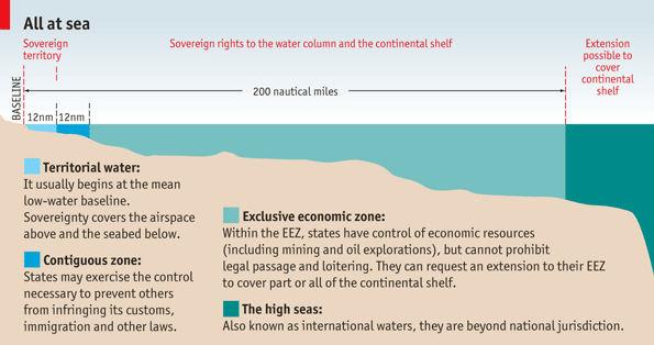
95 Superimposed Boundaries forcibly put on the landscape by outside parties, such as invaders or supranational organizations. Example : 1. The UN created borders of Israel in Yugoslavia and Iraq after the 1919 Treaty of Versailles after WWI


96 Relict Former State Boundaries that no longer functions as a borders, but that have political or cultural meaning Example The Berlin Wall CiejRqI
97 Border Disputes

98 Definitional Boundary Disputes Dispute based on the legal language of a boundary. Example: Japan and Russia have not agreed to the definition of the boundaries surrounding Kuril islands north of Japan. SOd0o

99 Locational Boundary Disputes Countries agree on the definition, but not on where the boundary exists on the earth or on a map. Example: Saudi Arabia and Yemen have agreed to a border, but not to exactly where that border is located.

100 Operational Boundary Disputes When borders are agreed to, but disputes over how a border should be operated or controlled. Example: The US/Mexican Border in regards to immigration and transport of goods.
 that lie on two sides of a border.")
101 Allocational Boundary Disputes Disputes over natural resources (mineral deposits, fertile farmland, or rich fishing groups) that lie on two sides of a border. Example: The US and Canada have fought over fishing grounds in the Atlantic Ocean.
102 Water Boundaries
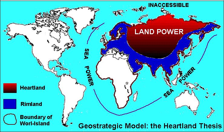
 are narrower than twice the standards or adopted")
103 Median-line Principal Drawing a political boundary midway between two states coastline when the territorial seas or EEZ(exclusive economic zone) are narrower than twice the standards or adopted limit.

104 Law of the Sea A collection of international laws and treaties that set rules for how States will use the oceans. WyzyAI
105 UNCLOS (UN Convention on the Law of the Sea) Territorial sea: Coastal States have claim to the sea up to 12 nautical miles from the shoreline Exclusive Economic Zone(EEZ): Coastal state can claim up to 200 nautical miles as an exclusive economic zone, control of resources (oil, fish, etc.) If there is not 200 nautical miles between two the median line principle will be used.
106
107 Global Commons The Global Commons refers to resources or areas that lie outside of the political reach of any one nation State. International law identifies four global commons: The High Seas The Atmosphere Antarctica Outer Space.
108

109 Geopolitics The process by which geopoliticians analyze how States behave as behavioral and territoral systems Analyzes why countries interact and compete in the political landscape. EX: Russian forces seizing Crimea
110 Ratzel s Organic Theory (19th Century) States are like living organisms. They hunger for land and want to grow larger and larger. To a state Land = Food. Ex. Hitler believed in and acted on this theory.
111 Heartland Theory (20th Century) Halford Mackfinder Era of sea power was ending and control over land would be the key to power. Controlling Northern and Central Asia(most populated landmasses) would be the key to dominating the world.
112
113 Rimland Theory Theory that the rimland of the Heartland was the key to power Rimland was the periphery extending from Western Europe, Southeast, South and East Asia. Important to balance power in the rimland to prevent a global power from emerging
114

115 The Domino Theory (Cold War Theory) Democratic allies must protect lands from falling to the communists, because if one country (domino) fell under the power of communism others in the region would also fall. Believed that this would result in communist domination of the world. Led to Vietnam war.
116 Primate Cities The political nucleus and the more economically powerful city in a state. Ex.
117 Question 7 What is a Supranational organization? Summarize the history of the United Nations (UN). What is the mission of the UN? Identify and discuss THREE global issues of current importance to the UN ( use this website to find these issues: )

118 The European Union International organization comprised of a dozen Western European countries to reduce trade barriers and increase cooperation among its This union has a unified currency the Euro.
119
120 Question 8 CURRENT EVENT: Locate a current events article (occurring within the past year) from a newspaper, news site (ex. NPR or BBC), or news magazine that relates to political geography. CITE your source by telling me the name of the article, source of the article, and when it was written. The event must be outside the United States. You will write two paragraphs: Paragraph one (4-6 Sentences) will explain the event the who, what, where, why and when. Paragraph two (4-6 Sentences) will draw connections between the event and FIVE Terms from Unit 7.
121 Multistate Nation When a nation stretches across borders and across states Examples: North Korea + South Korea


122 Geometric Boundary Boundaries drawn based on a grid system/straight lines such as line of latitude or longitude. Identify 1 Advantage/ 1 Disadvantage To the right lies Tijuana, Mexico and on the left is San Diego, California.

123 Cultural Boundary Estimated boundaries between nations, ethnic groups, or tribes. Identify 1 Advantage/ 1 Disadvantage

124 Natural/ Physical Political Boundary Boundaries that follow an agreed upon feature in the natural landscape. Ex. Pyrenees Mountains between Spain and France. Identify 1 Advantage/ 1 Disadvantage
PLEASE DO NOT WRITE ON THIS TEST BOOKLET. MULTIPLE CHOICE. Choose the one alternative that best completes the statement or answers the question.
 Unit 4 Assessment - Political Geography PLEASE DO NOT WRITE ON THIS TEST BOOKLET MULTIPLE CHOICE. Choose the one alternative that best completes the statement or answers the question. 1) The world's largest
Political Organizations of Space
 Political Organizations of Space Quiz Ferret!! Not natural Man Made Organization Study of human political organizations Organize Land Political organizations Political Structure 3 Levels Above Country
Political Geography Unit Test: Multiple Choice
 1. In political geography, a state is a a) nation b) country c) city d) county Political Geography Unit Test: Multiple Choice 2. At the global scale, territories are considered states when they have a)
Political Geography Unit Test (Version B)
") Political Geography Unit Test (Version B) Figure 1 1. What shape BEST describes the country shown in Figure 1 above? a. elongated b. perforated c. prorupted d. compact e. fragmented Figure 2 2. What shape
Political Geography Unit Test (Version B) Figure 1 1. What shape BEST describes the country shown in Figure 1 above? a. elongated b. perforated c. prorupted d. compact e. fragmented Figure 2 2. What shape
Chapter 8.1 Assignment
 Advanced Placement Human Geography Chapter 8.1 Assignment Political Geography State Territory Territoriality Sovereignty Territorial Integrity Nation Nation-state Multistate Nation Multinational State
IV. Political Organization of Space
 IV. Political Organization of Space Enduring Understandings Learning Objectives Essential Knowledge A. The contemporary political map has been shaped by events of the past Explain the structure of the
Essential Knowledge. Independent states are the primary building blocks of the world. Independent states, world political map
 A. The contemporary political map has been shaped by events of the past. B. Spatial political patterns reflect ideas of territoriality and power Explain the structure of the contemporary Explain the evolution
APHuG Vocabulary: Chapter 8 Political Geography
 APHuG Vocabulary: Chapter 8 Political Geography Directions: In the spaces provided, write a definition in your own words and identify a real-world (or reasonable potential real) example for each term.
5 Shapes of Countries and Enclaves and Exclaves
 5 Shapes of Countries and Enclaves and Exclaves Definition - The boundaries of a country and the shape of the land that it encompasses can present problems or it can help unify the nation. Each shape of
Chapter 8: Political Geography. Unit 4
 Chapter 8: Political Geography Unit 4 Where Are States Distributed? Introducing political geography State an area organized into a political unit and ruled by an established government that has control
State politically organized territory recognized by the international community. Must contain
 Political Geography State politically organized territory recognized by the international community. Must contain» 1) a permanent population» 2) a defined territory,» 3) a functioning government and economic
History of the State
 History of the State What did we have before states? What were those entities borders like? Where is the hearth of the modern state concept? Timeline of the development of the state idea. Greek and Roman
JANUARY 5, 2018 Prisoners of Geography Reading HW: Prisoners of Geography Reading Guide due Friday, Jan. 12 Story Map due Monday
 JANUARY 5, 2018 Prisoners of Geography Reading HW: Prisoners of Geography Reading Guide due Friday, Jan. 12 Story Map due Monday JANUARY 5, 2018 Get out stuff for notes Political Geography Intro Morphology
2) Korea is a good example of a 2) A) sovereign state. B) colony. C) patron-state.
 Korea is a good example of a 2) A) sovereign state. B) colony. C) patron-state.") AP Test 8 Review Name MULTIPLE CHOICE. Choose the one alternative that best completes the statement or answers the question. 1) A state which places most power in the hands of a central government is a
AP Test 8 Review Name MULTIPLE CHOICE. Choose the one alternative that best completes the statement or answers the question. 1) A state which places most power in the hands of a central government is a
Rubenstein s The Cultural Landscape Chapter 8: Political Geography
 Rubenstein s The Cultural Landscape Chapter 8: Political Geography Directions: The following worksheet accompanies your reading of the text. The key concepts and questions from the reading require bulleted
Chapter 9: Political Geography
 Chapter 9: Political Geography Introduction to Geography Lehman College GEH 101/GEH 501 Spring 2011 Keith Miyake Political Geography Study of the organization and distribution of political phenomena, e.g.:
HUMAN GEOGRAPHY. By Brett Lucas
 HUMAN GEOGRAPHY By Brett Lucas POLITICAL GEOGRAPHY Overview States Nationalism National Boundaries U.S. Political Geography States Defining States Problems of defining states Korea: one state or two? China
myworld Geography Eastern Hemisphere 2011
 A Correlation of to the Pennsylvania Assessment Anchor Standards Civics and Government Economics Geography History Grades 6-8 INTRODUCTION This document demonstrates how 2011 meets the objectives of the
myworld Geography 2011
 A Correlation of to the Pennsylvania Assessment Anchor Standards Social Studies Civics and Government Economics Geography History Grades 6-8 A Correlation of Pennsylvania Assessment Anchor Standards Social
INTRODUCING POLITICAL GEOGRAPHY
 Revised 2017 NAME: PERIOD: Rubenstein: The Cultural Landscape (12 th edition) Chapter Eight Political Geography (pages 264 thru 305) This is the primary means by which you will be taking notes this year
Political Geography. Chapter 8
 Political Geography Chapter 8 A World of States State An area organized into a political unit and ruled by an established government that has control over its internal and foreign affairs Sovereignty A
Chapter 8 Political Geography
 Chapter 8 Political Geography 1) Conflicting claims to the Arctic are mostly due to A) the potential for energy resources. 2) The most populous country that is not a member of the United Nations is A)
APHUG Chapter 8: Political Geography p.238
 P a g e 1 APHUG Chapter 8: Political Geography p.238 KI 1-4 Name Key Issues 1: Where Are States Located? 2: Why Do Boundaries Between States Cause Problems? 3: Why Do States Cooperate with Each Other?
MULTIPLE CHOICE. Choose the one alternative that best completes the statement or answers the question.
 Chapter 8 Exam Name MULTIPLE CHOICE. Choose the one alternative that best completes the statement or answers the question. 1) Terrorism differs from assassinations and other acts of political violence
WINTER. March 24. Template
 March 24 WINTER EQ- What are the different state shapes and types of boundaries? Agenda: 1. Daily Sheet 2. Review 3. Nation, State, Nation-States Gallery walk 4. Types of Boundaries Notes 4. Shapes of
Essential Understandings
 Spatial Divisions Essential Understandings Spatial divisions are regions of the earth s surface over which groups of people establish social, economic, and political control. Essential Understandings Spatial
Chapter 8 Learning Guide Political Geography
 Chapter 8 Learning Guide Political Geography Key Issue 1 Where Are States Located? Pgs. 238 247 Problems of Defining States 1. Define state: 2. Define sovereignty: 3. There is some disagreement about how
World Map Title Name. Russia. United States. Japan. Mexico. Philippines Nigeria. Brazil. Indonesia. Germany United Kingdom. Canada
 214 P Gersmehl Teachers may copy for use in their classrooms. Contact pgersmehl@gmail.com regarding permission for any other use. World Map Title Name Canada United States Mexico Colombia Ecuador Haiti
Levels and trends in international migration
 Levels and trends in international migration The number of international migrants worldwide has continued to grow rapidly over the past fifteen years reaching million in 1, up from million in 1, 191 million
6. Identify the reason for which membership in the UN grew significantly in each of the following periods.
 Due: Thursday. January 8 Last Chance: Friday, January 9 th Key Issue 1: Where Are States Distributed? Pages 260-267 1. Define state: Name: Period: 2. Define sovereignty: 3. List the 6 largest states in
Key Issue 1: Where Are States Distributed?
 Key Issue 1: Where Are States Distributed? Pages 260-267 ***Always keep your key term packet out whenever you take notes from Rubenstein. As the terms come up in the text, think through the significance
VISA POLICY OF THE REPUBLIC OF KAZAKHSTAN
 VISA POLICY OF THE REPUBLIC OF KAZAKHSTAN Country Diplomatic Service National Term of visafree stay CIS countries 1 Azerbaijan visa-free visa-free visa-free 30 days 2 Kyrgyzstan visa-free visa-free visa-free
Key Issue 1: Where Are States Distributed? (Pages )
") Key Issue 1: Where Are States Distributed? (Pages 266-269) 1. Define state: 2. List the 6 largest states in order. 3. How many microstates are recognized? What do many have in common? List 6 that you can
Key Issue 1: Where Are States Distributed? (Pages 266-269) 1. Define state: 2. List the 6 largest states in order. 3. How many microstates are recognized? What do many have in common? List 6 that you can
The Cultural Landscape Eleventh Edition
 Chapter 8 Lecture The Cultural Landscape Eleventh Edition Political Geography Matthew Cartlidge University of Nebraska-Lincoln Key Issues Where are states distributed? Why are nation-states difficult to
Nations: Borders & Power
 Nations: Borders & Power What factors determine where boundaries between countries are established? How do different countries related to one another? Political Regions Governments establish boundaries
Chapter 8: Political Geography
 Chapter 8: Political Geography Concept Caching: Burma, Myanmar Barbara Weightman Copyright Field Note: Independence Is Better than Servitude I arrived in Ghana just after an assassination attempt on the
Political Geography: On the Map
 Political Geography: On the Map Get ready to create a map that will help you understand the development of states and borders across the globe. You will need a pen and several highlighters. Before you
Your Questions Answered
 Your Questions Answered Things you Requested. United Nations Law of the Sea Feng Shui Cape Cod Blockbusting and Racial Steering 4 Asian Tigers Exclusive Economic Zone Domino Theory Colonial Powers Ozone
Political Geography. Chapter 8
 Political Geography Chapter 8 Where Are States Distributed? State Area organized into a political unit and ruled by an established gov t that has control over its internal and foreign affairs Occupies
How the US Acquires Clients. Contexts of Acquisition
 How the US Acquires Clients Contexts of Acquisition Some Basics of Client Acquisition Client acquisition requires the consent of both the US and the new client though consent of the client can be coercive
Translation from Norwegian
 Statistics for May 2018 Forced returns from Norway The National Police Immigration Service (NPIS) forcibly returned 402 persons in May 2018, and 156 of these were convicted offenders. The NPIS is responsible
The National Police Immigration Service (NPIS) forcibly returned 412 persons in December 2017, and 166 of these were convicted offenders.
 forcibly returned 412 persons in December 2017, and 166 of these were convicted offenders.") Monthly statistics December 2017: Forced returns from Norway The National Police Immigration Service (NPIS) forcibly returned 412 persons in December 2017, and 166 of these were convicted offenders. The
Monthly statistics December 2017: Forced returns from Norway The National Police Immigration Service (NPIS) forcibly returned 412 persons in December 2017, and 166 of these were convicted offenders. The
The National Police Immigration Service (NPIS) returned 444 persons in August 2018, and 154 of these were convicted offenders.
 returned 444 persons in August 2018, and 154 of these were convicted offenders.") Monthly statistics August 2018 Forced returns from Norway The National Police Immigration Service (NPIS) returned 444 persons in August 2018, and 154 of these were convicted offenders. The NPIS is responsible
Monthly statistics August 2018 Forced returns from Norway The National Police Immigration Service (NPIS) returned 444 persons in August 2018, and 154 of these were convicted offenders. The NPIS is responsible
Name Date Period. Quarter 3 Study Guide: Europe
 Name Date Period Quarter 3 Study Guide: Europe (1) SS6G8 The student will locate selected features of Europe. a. Locate on a world and regional political- physical map: the Danube River, Rhine River, English
Chapter 8 Political Geography Key Issue 1: Where Are States Distributed? [Pages ] DUE: FRI. JAN 12
![Chapter 8 Political Geography Key Issue 1: Where Are States Distributed? [Pages ] DUE: FRI. JAN 12](/thumbs/96/126774184.jpg "Chapter 8 Political Geography Key Issue 1: Where Are States Distributed? [Pages ] DUE: FRI. JAN 12") Name: Chapter 8 Political Geography Key Issue 1: Where Are States Distributed? [Pages 260-267] DUE: FRI. JAN 12 1. List the 6 largest states in order. 2. How many microstates are recognized? 3. What do
Name: Chapter 8 Political Geography Key Issue 1: Where Are States Distributed? [Pages 260-267] DUE: FRI. JAN 12 1. List the 6 largest states in order. 2. How many microstates are recognized? 3. What do
CHAPTER 8 POLITICAL GEOGRAPHY NOTES PART II
 CHAPTER 8 POLITICAL GEOGRAPHY NOTES PART II CENTRIPETAL AND CENTRIFUGAL FORCES Richard Hartshorne, a leading political geographer described Centripetal forces as things that bind or hold a nation together
WORLD HISTORY FROM 1300: THE MAKING OF THE MODERN WORLD
 (Elective) World History from 1300: The Making of the Modern World is designed to assist students in understanding how people and countries of the world have become increasingly interconnected. In the
The Historical Evolution of International Relations
 The Historical Evolution of International Relations Chapter 2 Zhongqi Pan 1 Ø Greece and the City-State System p The classical Greek city-state system provides one antecedent for the new Westphalian order.
THE COLD WAR Learning Goal 1:
 THE COLD WAR Learning Goal 1: Describe the causes and effects of the Cold War and explain how the Korean War, Vietnam War and the arms race were associated with the Cold War. RESULTS OF WWII RESULTS VE
REGIONS OF THE WORLD
 REGIONS OF THE WORLD NORTH AMERICA Some countries: 3 Nations: USA, Mexico, Canada Population: Power: Main Languages: English, Spanish, French Religion: Mostly Christian, but many other groups Number of
Where is Europe located?
 Where is Europe located? Where in the world is Europe? How does Texas compare to Europe? How does the U.S. compare to Europe? Albania Andorra Austria Belarus Belgium Bosnia and Herzegovina Bulgaria Croatia
Chapter 8 Political Geography Pearson Education, Inc.
 Chapter 8 Political Geography Political Geography: Key Issues 1. Where Are States Distributed? 2. Why Are Nation-States Difficult to Create? 3. Why Do Boundaries Cause Problems? 4. Where Do States Face
Maine Learning Results Social Studies
 A Correlation of To the Social Studies Grade 6-8 Introduction This document demonstrates how myworld History, meets the Maine Learning Results,. Correlation page references are to the Student Edition and
Chapter 8: Political Geography
 Chapter 8: Political Geography EQ: How does political geography impact human activity? The Cultural Landscape: An Introduction to Human Geography Where Are States Located? Problems of defining states Almost
7th Grade First Semester Test
 7th Grade First Semester Test 2013-2014 Multiple Choice Identify the choice that best completes the statement or answers the question. 1 Study the map below and use it to answer the following question.
KINGDOM OF CAMBODIA NATION RELIGION KING 3 TOURISM STATISTICS REPORT. September 2010
 KINGDOM OF CAMBODIA NATION RELIGION KING 3 TOURISM STATISTICS REPORT September 2010 MINISTRY OF TOURISM Statistics and Tourism Information Department No. A3, Street 169, Sangkat Veal Vong, Khan 7 Makara,
Tourism Highlights International Tourist Arrivals, Average Length of Stay, Hotels Occupancy & Tourism Receipts Years
 KINGDOM OF CAMBODIAA NATION RELIGION KING 3 TOURISM STATISTICS REPORT Oct tober 2013 MINISTRY OF TOURISM Statisticss and Tourism Information Department No. A3, Street 169, Sangkat Veal Vong, Khann 7 Makara,
UNIT 4: POLITICAL GEOGRAPHY by Dan Snyder
 UNIT 4: POLITICAL GEOGRAPHY by Dan Snyder Chapter Outlines Chapter 14 Chapter 15 Chapter 16 Chapter 17 Key Concepts [A] Territorial Dimensions of Politics [B] Evolution of the Contemporary Political Pattern
Middle School Level. Middle School Section I
 017 Montessori Model UN New York Conference Matrix DISEC ECOFIN SOCHUM LEGAL SPECPOL UNGA5 UNSC Japan 14 People s Republic of China 14 Republic of Angola 14 Republic of France 14 Russian Federation 14
World Refugee Survey, 2001
 World Refugee Survey, 2001 Refugees in Africa: 3,346,000 "Host" Country Home Country of Refugees Number ALGERIA Western Sahara, Palestinians 85,000 ANGOLA Congo-Kinshasa 12,000 BENIN Togo, Other 4,000
The NPIS is responsible for forcibly returning those who are not entitled to stay in Norway.
 Monthly statistics December 2014: Forced returns from Norway The National Police Immigration Service (NPIS) forcibly returned 532 persons in December 2014. 201 of these returnees had a criminal conviction
The National Police Immigration Service (NPIS) forcibly returned 375 persons in March 2018, and 136 of these were convicted offenders.
 forcibly returned 375 persons in March 2018, and 136 of these were convicted offenders.") Statistics March 2018: Forced returns from Norway The National Police Immigration Service (NPIS) forcibly returned 375 persons in March 2018, and 136 of these were convicted offenders. The NPIS is responsible
Statistics March 2018: Forced returns from Norway The National Police Immigration Service (NPIS) forcibly returned 375 persons in March 2018, and 136 of these were convicted offenders. The NPIS is responsible
Political Geography. What is a state? Development of the State Concept. Development of the State Concept. Problematic States. Problematic States
 What is a state? Political Geography A region on the earth that has: Defined territory Population Political structure Sovereignty country is synonymous with state nation is synonymous with ethnicity Development
Chapter 8. Political Geography
 Chapter 8 Political Geography Key Issue #1 Where are states located? Defining States & Development of the State Concept Problems of defining states Korea: one state or two? China & Taiwan: one state or
language religion and ethnicity nationalism
 Political Geography Internal Politics Centripetal forces vs. Attitude or force that unifies and enhances support for state a single native language or a colonial official language English in India, Nigeria
PROTOCOL RELATING TO AN AMENDMENT TO THE CONVENTION ON INTERNATIONAL CIVIL AVIATION ARTICLE 45, SIGNED AT MONTREAL ON 14 JUNE parties.
 PROTOCOL RELATING TO AN AMENDMENT TO THE CONVENTION ON INTERNATIONAL CIVIL AVIATION ARTICLE 45, SIGNED AT MONTREAL ON 14 JUNE 1954 State Entry into force: The Protocol entered into force on 16 May 1958.
Divided into 4 zones of occupation; Berlin also divided
 Cold War 1945-1989 Germany Divided into 4 zones of occupation; Berlin also divided Japan Occupied by U.S. troops Demilitarized Industries re-built with modern machinery Divided into 2 zones of occupation
Using your Cold War packet as a resource, follow the directions and complete the Postwar Soviet Expansion packet. Due at the end of the period.
 ASh CP and Honors Name: Mr. Bossio Period: Date: Postwar Soviet Expansion: Imperialism or SelfDefense? Objective: To understand possible explanations for Soviet expansion in the immediate postwar period.
KINGDOM OF CAMBODIA NATION RELIGION KING 3 TOURISM STATISTICS REPORT. March 2010
 KINGDOM OF CAMBODIA NATION RELIGION KING 3 TOURISM STATISTICS REPORT March 2010 MINISTRY OF TOURISM Statistics and Tourism Information Department No. A3, Street 169, Sangkat Veal Vong, Khan 7 Makara, Phnom
Good Sources of International News on the Internet are: ABC News-
 Directions: AP Human Geography Summer Assignment Ms. Abruzzese Part I- You are required to find, read, and write a description of 5 current events pertaining to a country that demonstrate the IMPORTANCE
Delays in the registration process may mean that the real figure is higher.
 Monthly statistics December 2013: Forced returns from Norway The National Police Immigration Service (NPIS) forcibly returned 483 persons in December 2013. 164 of those forcibly returned in December 2013
List of Main Imports to the United States
 Example List 1 CANADA CHINA JAPAN MEXICO List 1 ARGENTINA AUSTRALIA BELGIUM COSTA RICA COTE D IVOIRE KUWAIT NORWAY SOUTH KOREA SRI LANKA SUDAN List 2 BRAZIL DOMINICAN REPUBLIC FRANCE NEW ZEALAND QATAR
Europe and North America Section 1
 Europe and North America Section 1 Europe and North America Section 1 Click the icon to play Listen to History audio. Click the icon below to connect to the Interactive Maps. Europe and North America Section
Return of convicted offenders
 Monthly statistics December : Forced returns from Norway The National Police Immigration Service (NPIS) forcibly returned 869 persons in December, and 173 of these were convicted offenders. The NPIS forcibly
Session 2: The importance of institutions and standards for soft connectivity
 ASEM Seminar, Tokyo 12 September 2018 Hae-Won Jun, KNDA Session 2: The importance of institutions and standards for soft connectivity How is digital connectivity important between Asia and Europe and what
Required Reading for this Unit: Geopolitics. The Nation State. What is Geopolitics?
 2 Required Reading for this Unit: A Sure Path to Conflict? 3 4 What is? The interplay (relationship) between geography and politics on either a national or international level. The Nation State Independent
Montessori Model United Nations - NYC Conference March 2018
 Montessori Model United Nations - NYC Conference March 018 Middle School Level COMMITTEES COUNTRIES Maximum Number of Delegates per Committee DISEC 1 DISEC LEGAL SPECPOL SOCHUM ECOFIN 1 ECOFIN UNSC UNGA
Business Data For Engaging in International Real Estate Transactions in California. National Association of REALTORS Research Division
 Business Data For Engaging in International Real Estate Transactions in National Association of REALTORS Research Division November 2016 Table of Contents Introduction 1 Table 1. Population by Place of
The Roots of the Cold War
 The Roots of the Cold War Communism No real wealthy people State/country controls everything business related No free enterprise system 1 ruler that can easily turn into a dictatorship Roots of the Cold
Overview: The World Community from
 Overview: The World Community from 1945 1990 By Encyclopaedia Britannica, adapted by Newsela staff on 06.15.17 Word Count 874 Level 1050L During the Soviet invasion of Czechoslovakia in 1968, Czechoslovakians
Unit 7: The Cold War
 Unit 7: The Cold War Standard 7-5 Goal: The student will demonstrate an understanding of international developments during the Cold War era. Vocabulary 7-5.1 OCCUPIED 7-5.2 UNITED NATIONS NORTH ATLANTIC
IMMIGRATION. Gallup International Association opinion poll in 69 countries across the globe. November-December 2015
 IMMIGRATION Gallup International Association opinion poll in 69 countries across the globe November-December 2015 Disclaimer: Gallup International Association or its members are not related to Gallup Inc.,
Name - HONORS AMERICAN GOVERNMENT UNIT #1
 Name - HONORS AMERICAN GOVERNMENT UNIT #1 1. 10. 2. 11. 3. 12. 4. 13. 5. EXTRA CREDIT 6. 7. 8. 9. TOTAL POINTS X _.27 = % 369 RESOURCE PAGES 4-24 Goals for this unit are: To be able to create and read
3/21/ Global Migration Patterns. 3.1 Global Migration Patterns. Distance of Migration. 3.1 Global Migration Patterns
 3.1 Global Migration Patterns Emigration is migration from a location; immigration is migration to a location. Net migration is the difference between the number of immigrants and emigrants. Geography
WW II Homework Packet #3 Honors (Ch ) Life under a dictator or totalitarian can be difficult. Describe life under this form of government
 Life under a dictator or totalitarian can be difficult. Describe life under this form of government") Name: WW II Homework Packet #3 Honors (Ch. 15-16) Determine whether each statement below is true or false. 1. Blitzkrieg means lightning war. T or F 2. The Luftwaffe was the Soviet Air Force. T or F 3.
Name: WW II Homework Packet #3 Honors (Ch. 15-16) Determine whether each statement below is true or false. 1. Blitzkrieg means lightning war. T or F 2. The Luftwaffe was the Soviet Air Force. T or F 3.
Georgia 7th Grade Clickbook Page-by-Page Outline
 Georgia 7th Grade Clickbook Page-by-Page Outline Special Content Color Key: Related Module(s) Expansion Activity Click&Learn Activity Summative Assessment Page Name & Description Special Content Unit 1:
New York County Lawyers Association Continuing Legal Education Institute 14 Vesey Street, New York, N.Y (212)
") New York County Lawyers Association Continuing Legal Education Institute 14 Vesey Street, New York, N.Y. 10007 (212) 267-6646 Who is Who in the Global Economy And Why it Matters June 20, 2014; 6:00 PM-6:50
New York County Lawyers Association Continuing Legal Education Institute 14 Vesey Street, New York, N.Y. 10007 (212) 267-6646 Who is Who in the Global Economy And Why it Matters June 20, 2014; 6:00 PM-6:50
Teachers Name: Nathan Clayton Course: World History Academic Year/Semester: Fall 2012-Spring 2013
 Amory High School Curriculum Map Teachers Name: Nathan Clayton Course: World History Academic Year/Semester: Fall 2012-Spring 2013 Essential Questions First Nine Weeks Second Nine Weeks Third Nine Weeks
Propose solutions to challenges brought on by modern industrialization and globalization.
 Core Content for Assessment: SS-HS-5.3.1 Title / Topic: Classical and Medieval Review, Renaissance and Reformation DOK 2 Define democracy, republic, empire, secular, humanism, theocracy, Protestant Reformation,
Conflict in the 21 st Century
 The Nature of Conflict Conflict in the 21 st Century Chapter 22 Page 349 Conflict on the global stage usually have one of three outcomes: 1. An acceptable solution is found, suitable to all. 2. Parties
Investigating the Geology and Geography of Oil
 S t u d e n t H a n d o u t a Investigating the Geology and Geography of Oil Land Area of Oil Countries of Southwest Asia Examine the map at right. It shows the locations of 10 oil countries in Southwest
SEPT 6, Fall of USSR and Yugoslavia Get out notebook, ESPN highlighters, and pencil
 SEPT 6, 2017 Fall of USSR and Yugoslavia Get out notebook, ESPN highlighters, and pencil EQ: How did the fall of communism lead to the turmoil in Yugoslavia in the 1990s? Problems of Soviet Union in 1980
Name Period Cold War Germany Divided into zones of occupation; also
 Name Period Cold War 1945-1989 Germany Divided into zones of occupation; also Japan by U.S. troops Industries re-built with modern Korea into zones of occupation (USSR and US) Boundary is parallel (38
Chapter 8 Political Geography
 Chapter 8 Political Geography The facts! Political geography- way governments organize and administer space Wars have broken out over political control Within states & between neighboring states Geographers
THE WORLD IN THE TWENTIETH CENTURY
 Fourth Edition THE WORLD IN THE TWENTIETH CENTURY From Empires to Nations \ \ DANJEL R. BROWER University of Calif&nia-Davis PRENTICE HALL, Upper Saddle River, New Jersey 07458 Contents Maps, vi Preface,
MIGRATION IN SPAIN. "Facebook or face to face? A multicultural exploration of the positive and negative impacts of
 "Facebook or face to face? A multicultural exploration of the positive and negative impacts of Science and technology on 21st century society". MIGRATION IN SPAIN María Maldonado Ortega Yunkai Lin Gerardo
Contemporary theory, practice and cases By Ilan Alon, Eugene Jaffe, Christiane Prange & Donata Vianelli
 Global Marketing Contemporary theory, practice and cases By Ilan Alon, Eugene Jaffe, Christiane Prange & Donata Vianelli Chapter 3 Regional Trade and Emerging Markets Learning objectives After reading
CHILE NORTH AMERICA. Egypt, Israel, Oman, Saudi Arabia and UAE. Barge service: Russia Federation, South Korea and Taiwan. USA East Coast and Panama
 EUROPE Bulgaria, Greece, Italy, Netherlands and Turkey Belgium, Denmark, France, Germany, Malta, Netherlands, Poland, Slovenia, Spain and UK Belgium, Germany, Gibraltar, Greece, Italy, Malta, Netherlands,
AMNESTY INTERNATIONAL REPORT 1997
 EMBARGOED UNTIL 0001 HRS GMT, WEDNESDAY 18 JUNE 1997 AMNESTY INTERNATIONAL REPORT 1997 Annual Report Statistics 1997 AI INDEX: POL 10/05/97 NOTE TO EDITORS: The following statistics on human rights abuses
Changes in Russia, Asia, & the Middle East TOWARD A GLOBAL COMMUNITY (1900 PRESENT)
") Changes in Russia, Asia, & the Middle East TOWARD A GLOBAL COMMUNITY (1900 PRESENT) RUSSIA Toward the end of WWI Russia entered a civil war between Lenin s Bolsheviks (the Communist Red Army) and armies
Changes in Russia, Asia, & the Middle East TOWARD A GLOBAL COMMUNITY (1900 PRESENT) RUSSIA Toward the end of WWI Russia entered a civil war between Lenin s Bolsheviks (the Communist Red Army) and armies