State politically organized territory recognized by the international community. Must contain
|
|
|
- Amanda Ward
- 5 years ago
- Views:
Transcription


1 Political Geography
2 State politically organized territory recognized by the international community. Must contain» 1) a permanent population» 2) a defined territory,» 3) a functioning government and economic system Nation tightly knit group of people who feel a belonging to a cultural community, share a common history (stateless nations no national territory; Kurds, Palestinians)

3 Evolution of the Nation-State Treaty of Westphalia (1648) sets legal precedent for national sovereignty states have the right to make decisions for themselves Doctrine of nationalism, creates supreme loyalty to our people Colonialism rose from European countries seeking wealth and often disregarded local sovereignty
4 Territorial Morphology: Size not always an advantage U.S. = yes (resources, relative location) U.S. = no (large heterogeneous population, size and long borders create challenges) Microstates - Liechtenstein, Luxembourg, Monaco Relative location - situation Resources exceptions: Congo (resource-rich but unable to use for own benefit); Switzerland & Japan (few resources, but in economic cores) Global Activity Singapore has access to many trade routes

5 Singapore: Microstate but wealthy

6 Shape Compact distance from geometric center is similar Elongated a.k.a. attenuated Fragmented two or more separate pieces Perforated territory completely surrounds that of another state Protruded a.k.a. prorupt; have a protruded area that extends from a more compact core
7 Evolution of Boundaries Boundary a vertical plane that cuts through the subsoil & airspace (even outer space) Definition legal document or treaty drawn up to specify actual points in the landscape Delimitation cartographers put the boundary on the map Demarcation boundary is actually marked on the ground w/ wall, fence, posts, Types of Boundaries Geometric straight-line, unrelated to physical or cultural landscape, lat & long (US/Canada) Physical-political (natural-political) conform to physiologic features (Rio Grande: US/Mexico; Pyrenees: Spain/France)
8 Boundary Disputes Definitional focus on legal language (e.g. median line of a river: water levels may vary) Locational definition is not in dispute, the interpretation is; allows mapmakers to delimit boundaries in various ways Operational neighbors differ over the way the boundary should function (migration, smuggling) Allocational disputes over rights to natural resources (gas, oil, water) Almost all boundary disputes today are operational or allocational.

9 Major area of dispute w/ Iraq in 1990s Relative Location of Kuwait

10 Colonialism has changed the global order of politics; often creating unequal cultural and economic relations
11 Core-Periphery Model World Systems Analysis (Immanuel Wallerstein) view the world as an interlocked system of states Core economically dominant states Periphery developing states; have little autonomy or influence Semi-periphery middle; keeps the world from being polarized into two extremes The world must be seen as a system of interlinking parts; ties political and economic geography together

12 World Incomes
13 Geopolitics: Heartland Theory: Halford Mackinder (Br) Heart of Eurasia resource-rich, land-based pivot area - military focus is the army Rimland Theory: Nicholas Spykman (US) Eurasian rim, not heart focus on the navy The US does not fit into either theory

14 Mackinder s Heartland Theory & Spykman s Rimland Theory
15 Cities in political geography Capital city pol. nerve center, seat of gov t, center of nat. life, & nat. headquarters Forward capital capital city moved for a nat. objective; culture, disputed territory, Primate city By far the largest city; most expressive of culture, may be capital: Mexico City, Paris, Jakarta, (many countries don t have: e.g. US)

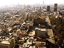
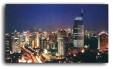
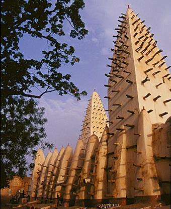
16 Paris, Fr. Ouagadougou, B.F. Mexico City, Mex. Jakarta, Indo.
17 Unitary state nation-state w/ highly centralized gov t, central authority exerts power equally over its territory (UK, Fr) Federal state central gov t represents various entities w/in a nation-state, allows entities to retain some power (Canada, US) Electoral geography: US 435 seats in House, after 1990 census, gov t instructed States to develop majority-minority districts Gerrymandering redistricting for advantage; 1812 Gov. Gerry of Massachusetts (salamander-looking dist.)


18 Gerrymander Florida s 3 rd Cong. Dist ,000 African-Americans 240,000 whites 16,000 Hispanics


19 Tarrant County Below the State Boundaries

20 Local self-government (municipalities) Southlake Tarrant County white = Fort Worth yellow= unincorporated
21 Centripetal Forces promote unity Charismatic leaders, external threats (Iraq) Nationalism religion, education, national ideology, Centrifugal Forces divisive forces Internal religious, linguistic, ethnic, or ideological differences Tribalism people identify more w/ their local affiliation than with their country
 and/or cultural (African Union) objectives Benelux first multinational union; no tariffs, quotas,")
22 Supranationalism: Venture involving three or more states for pol. (UN), econ. (EU), mil. (NATO) and/or cultural (African Union) objectives Benelux first multinational union; no tariffs, quotas, licenses; joined EEC later

23 BeNeLux

24 Members of the European Union (EU)
; Tibetans, Kurds, Australian Aborigines, Not a world gov t, no")
25 United Nations established after WWII (much more successful than the League of Nations); 193 members inc. South Sudan UNPO unrepresented people (53 members); Tibetans, Kurds, Australian Aborigines, Not a world gov t, no standing army
 in 1982; territorial sea up to 12 naut. miles, EEZ (Exclusive Econ. Zone) up to 200 naut. miles (rights to nat. resources up to cont.")
26 Truman Proclamation (1945) had claimed natural resources up to continental shelf Argentina (in 1946) claimed water above UNCLOS (UN Convention on Law of Sea) signed by 157 states (not US) in 1982; territorial sea up to 12 naut. miles, EEZ (Exclusive Econ. Zone) up to 200 naut. miles (rights to nat. resources up to cont. shelf)

27 Median-line Principle: Drawing a boundary midway b/w two states coasts when terr. sea or EEZ conflict South China Sea area of major disputes; Spratly Is. (rich in oil, claimed by six states)
28 Devolution when regions within a state gain political strength and growing autonomy at the expense of the central gov t Ethnonationalism love for your nation Scotland voted in favor of greater autonomy, vote for total independence failed Spain Basque, Catalonia: 17 Autonomous Communities established Belgium Flemish (Dutch) vs. Walloon (Fr.) Yugoslavia six republics ; Dayton Accords (1995) split Bosnia b/w Serb Republic & Muslim-Croat Federation


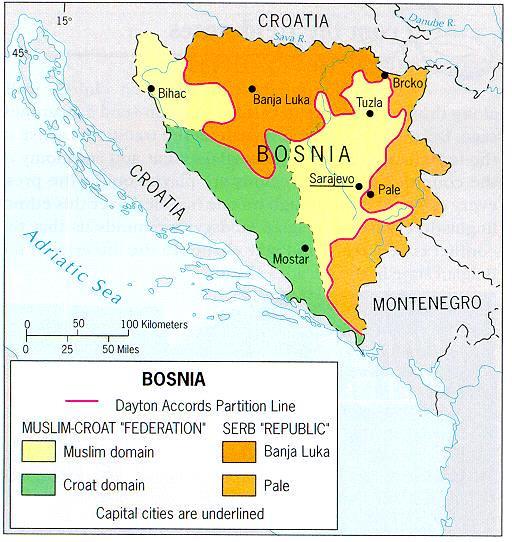
29 Regions of devolution due to ethnonationalism Scotland, Belgium, and Bosnia
30 More causes of devolution Economic Spain Catalonia (industrially strong) Italy North (industrially strong) France Corsica (island) Brazil South (federal govt. misuse of taxes) Spatial - Distance, remoteness & peripheral location are allies of devolution

31 Devolutionary Pressures in Europe, 2002
32 More changes: Growing influence of religion religious fundamentalism vs. secularism, stereotypes (Islamic world vs. Judeo-Christian world) Antiquated boundary framework 21 st c. world w/ 19 th c. borders (most devolving movements occur in periphery of states) Rise of terrorism superpowers supplied allies w/ weapons during Cold War; increasing threat of nations w/ nukes, chemical & biological weapons, suicide missions = potential to unite or divide world Shatterbelts - region of the world in which there are problems with a large number of smaller nations leading to state problems.
Essential Knowledge. Independent states are the primary building blocks of the world. Independent states, world political map
 A. The contemporary political map has been shaped by events of the past. B. Spatial political patterns reflect ideas of territoriality and power Explain the structure of the contemporary Explain the evolution
Political Geography Unit Test: Multiple Choice
 1. In political geography, a state is a a) nation b) country c) city d) county Political Geography Unit Test: Multiple Choice 2. At the global scale, territories are considered states when they have a)
APHuG Vocabulary: Chapter 8 Political Geography
 APHuG Vocabulary: Chapter 8 Political Geography Directions: In the spaces provided, write a definition in your own words and identify a real-world (or reasonable potential real) example for each term.
IV. Political Organization of Space
 IV. Political Organization of Space Enduring Understandings Learning Objectives Essential Knowledge A. The contemporary political map has been shaped by events of the past Explain the structure of the
Chapter 8.1 Assignment
 Advanced Placement Human Geography Chapter 8.1 Assignment Political Geography State Territory Territoriality Sovereignty Territorial Integrity Nation Nation-state Multistate Nation Multinational State
PLEASE DO NOT WRITE ON THIS TEST BOOKLET. MULTIPLE CHOICE. Choose the one alternative that best completes the statement or answers the question.
 Unit 4 Assessment - Political Geography PLEASE DO NOT WRITE ON THIS TEST BOOKLET MULTIPLE CHOICE. Choose the one alternative that best completes the statement or answers the question. 1) The world's largest
Political Geography Unit Test (Version B)
") Political Geography Unit Test (Version B) Figure 1 1. What shape BEST describes the country shown in Figure 1 above? a. elongated b. perforated c. prorupted d. compact e. fragmented Figure 2 2. What shape
Political Geography Unit Test (Version B) Figure 1 1. What shape BEST describes the country shown in Figure 1 above? a. elongated b. perforated c. prorupted d. compact e. fragmented Figure 2 2. What shape
Political Organizations of Space
 Political Organizations of Space Quiz Ferret!! Not natural Man Made Organization Study of human political organizations Organize Land Political organizations Political Structure 3 Levels Above Country
CHAPTER 8 POLITICAL GEOGRAPHY NOTES PART II
 CHAPTER 8 POLITICAL GEOGRAPHY NOTES PART II CENTRIPETAL AND CENTRIFUGAL FORCES Richard Hartshorne, a leading political geographer described Centripetal forces as things that bind or hold a nation together
MULTINATIONALISM and the CHANGING POLITICAL LANDSCAPE
 MULTINATIONALISM and the CHANGING POLITICAL LANDSCAPE Devolution The movement of power from the central government to regional governments within the state. Ethnocultural Devolutionary Movements Nations
2) Korea is a good example of a 2) A) sovereign state. B) colony. C) patron-state.
 Korea is a good example of a 2) A) sovereign state. B) colony. C) patron-state.") AP Test 8 Review Name MULTIPLE CHOICE. Choose the one alternative that best completes the statement or answers the question. 1) A state which places most power in the hands of a central government is a
AP Test 8 Review Name MULTIPLE CHOICE. Choose the one alternative that best completes the statement or answers the question. 1) A state which places most power in the hands of a central government is a
AP HUMAN GEOGRAPHY Unit 7: POLITICAL GEOGRAPHY (Ch.8)
") AP HUMAN GEOGRAPHY Unit 7: POLITICAL GEOGRAPHY (Ch.8) Political Geography The study of human political organization of the earth. Study political organization at three scales: Supranational (Organizations
AP HUMAN GEOGRAPHY Unit 7: POLITICAL GEOGRAPHY (Ch.8) Political Geography The study of human political organization of the earth. Study political organization at three scales: Supranational (Organizations
History of the State
 History of the State What did we have before states? What were those entities borders like? Where is the hearth of the modern state concept? Timeline of the development of the state idea. Greek and Roman
Chapter 9: Political Geography
 Chapter 9: Political Geography Introduction to Geography Lehman College GEH 101/GEH 501 Spring 2011 Keith Miyake Political Geography Study of the organization and distribution of political phenomena, e.g.:
UNIT 4: POLITICAL GEOGRAPHY by Dan Snyder
 UNIT 4: POLITICAL GEOGRAPHY by Dan Snyder Chapter Outlines Chapter 14 Chapter 15 Chapter 16 Chapter 17 Key Concepts [A] Territorial Dimensions of Politics [B] Evolution of the Contemporary Political Pattern
JANUARY 5, 2018 Prisoners of Geography Reading HW: Prisoners of Geography Reading Guide due Friday, Jan. 12 Story Map due Monday
 JANUARY 5, 2018 Prisoners of Geography Reading HW: Prisoners of Geography Reading Guide due Friday, Jan. 12 Story Map due Monday JANUARY 5, 2018 Get out stuff for notes Political Geography Intro Morphology
APHUG Chapter 8: Political Geography p.238
 P a g e 1 APHUG Chapter 8: Political Geography p.238 KI 1-4 Name Key Issues 1: Where Are States Located? 2: Why Do Boundaries Between States Cause Problems? 3: Why Do States Cooperate with Each Other?
5 Shapes of Countries and Enclaves and Exclaves
 5 Shapes of Countries and Enclaves and Exclaves Definition - The boundaries of a country and the shape of the land that it encompasses can present problems or it can help unify the nation. Each shape of
HUMAN GEOGRAPHY. By Brett Lucas
 HUMAN GEOGRAPHY By Brett Lucas POLITICAL GEOGRAPHY Overview States Nationalism National Boundaries U.S. Political Geography States Defining States Problems of defining states Korea: one state or two? China
Rubenstein s The Cultural Landscape Chapter 8: Political Geography
 Rubenstein s The Cultural Landscape Chapter 8: Political Geography Directions: The following worksheet accompanies your reading of the text. The key concepts and questions from the reading require bulleted
Supranationalism and Devolution in a Changing World
 Supranationalism and Devolution in a Changing World Political boundaries structure human affairs and understandings. Political boundaries of significance exist both 'above' and 'below' the state. Below
Political Geography. What is a state? Development of the State Concept. Development of the State Concept. Problematic States. Problematic States
 What is a state? Political Geography A region on the earth that has: Defined territory Population Political structure Sovereignty country is synonymous with state nation is synonymous with ethnicity Development
Chapter 8: Political Geography. Unit 4
 Chapter 8: Political Geography Unit 4 Where Are States Distributed? Introducing political geography State an area organized into a political unit and ruled by an established government that has control
MULTIPLE CHOICE. Choose the one alternative that best completes the statement or answers the question.
 Chapter 8 Exam Name MULTIPLE CHOICE. Choose the one alternative that best completes the statement or answers the question. 1) Terrorism differs from assassinations and other acts of political violence
Chapter 8: Political Geography
 Chapter 8: Political Geography Concept Caching: Burma, Myanmar Barbara Weightman Copyright Field Note: Independence Is Better than Servitude I arrived in Ghana just after an assassination attempt on the
language religion and ethnicity nationalism
 Political Geography Internal Politics Centripetal forces vs. Attitude or force that unifies and enhances support for state a single native language or a colonial official language English in India, Nigeria
WINTER. March 24. Template
 March 24 WINTER EQ- What are the different state shapes and types of boundaries? Agenda: 1. Daily Sheet 2. Review 3. Nation, State, Nation-States Gallery walk 4. Types of Boundaries Notes 4. Shapes of
Key Concepts & Resources
 Unit Plan Unit IV-Political Organization of Space Description of Unit (Source: AP Human Geography Course Description) This section of the course introduces students to the nature and significance of the
Chapter 8 Political Geography
 Chapter 8 Political Geography 1) Conflicting claims to the Arctic are mostly due to A) the potential for energy resources. 2) The most populous country that is not a member of the United Nations is A)
Chapter 8: Political Geography
 Chapter 8: Political Geography EQ: How does political geography impact human activity? The Cultural Landscape: An Introduction to Human Geography Where Are States Located? Problems of defining states Almost
Political Geography. Chapter 8
 Political Geography Chapter 8 A World of States State An area organized into a political unit and ruled by an established government that has control over its internal and foreign affairs Sovereignty A
INTRODUCING POLITICAL GEOGRAPHY
 Revised 2017 NAME: PERIOD: Rubenstein: The Cultural Landscape (12 th edition) Chapter Eight Political Geography (pages 264 thru 305) This is the primary means by which you will be taking notes this year
Political Geography. Chapter 8
 Political Geography Chapter 8 Where Are States Distributed? State Area organized into a political unit and ruled by an established gov t that has control over its internal and foreign affairs Occupies
The Cultural Landscape Eleventh Edition
 Chapter 8 Lecture The Cultural Landscape Eleventh Edition Political Geography Matthew Cartlidge University of Nebraska-Lincoln Key Issues Where are states distributed? Why are nation-states difficult to
Chapter 8 Political Geography Pearson Education, Inc.
 Chapter 8 Political Geography Political Geography: Key Issues 1. Where Are States Distributed? 2. Why Are Nation-States Difficult to Create? 3. Why Do Boundaries Cause Problems? 4. Where Do States Face
Key Issue 1: Where Are States Distributed? (Pages )
") Key Issue 1: Where Are States Distributed? (Pages 266-269) 1. Define state: 2. List the 6 largest states in order. 3. How many microstates are recognized? What do many have in common? List 6 that you can
Key Issue 1: Where Are States Distributed? (Pages 266-269) 1. Define state: 2. List the 6 largest states in order. 3. How many microstates are recognized? What do many have in common? List 6 that you can
Chapter 8 Learning Guide Political Geography
 Chapter 8 Learning Guide Political Geography Key Issue 1 Where Are States Located? Pgs. 238 247 Problems of Defining States 1. Define state: 2. Define sovereignty: 3. There is some disagreement about how
6. Identify the reason for which membership in the UN grew significantly in each of the following periods.
 Due: Thursday. January 8 Last Chance: Friday, January 9 th Key Issue 1: Where Are States Distributed? Pages 260-267 1. Define state: Name: Period: 2. Define sovereignty: 3. List the 6 largest states in
Key Issue 1: Where Are States Distributed?
 Key Issue 1: Where Are States Distributed? Pages 260-267 ***Always keep your key term packet out whenever you take notes from Rubenstein. As the terms come up in the text, think through the significance
Political Geography: On the Map
 Political Geography: On the Map Get ready to create a map that will help you understand the development of states and borders across the globe. You will need a pen and several highlighters. Before you
Chapter 8. Political Geography
 Chapter 8 Political Geography Key Issue #1 Where are states located? Defining States & Development of the State Concept Problems of defining states Korea: one state or two? China & Taiwan: one state or
Globaliza(on. Scale (from local to global) = Globaliza4on. Economic globaliza4on. Cultural globaliza4on
 = Globaliza4on. Economic globaliza4on. Cultural globaliza4on") Globaliza(on Scale (from local to global) = Globaliza4on Economic globaliza4on Mul4na4onal/Transna4onal corpora4ons Free trade Cheap OIL Cultural globaliza4on Mass communica4ons Popular culture and uniform
Globaliza(on Scale (from local to global) = Globaliza4on Economic globaliza4on Mul4na4onal/Transna4onal corpora4ons Free trade Cheap OIL Cultural globaliza4on Mass communica4ons Popular culture and uniform
Federal Register / Vol. 60, No. 163 / Wednesday, August 23, 1995 / Notices
 43825 12. If you were a Cabinet Secretary, would you hire this person to be a key member of your staff? 13. What would you expect this candidate to be doing in 15 to 20 years? Privacy Act and Paperwork
Chapter 8 Political Geography Key Issue 1: Where Are States Distributed? [Pages ] DUE: FRI. JAN 12
![Chapter 8 Political Geography Key Issue 1: Where Are States Distributed? [Pages ] DUE: FRI. JAN 12](/thumbs/96/126774184.jpg "Chapter 8 Political Geography Key Issue 1: Where Are States Distributed? [Pages ] DUE: FRI. JAN 12") Name: Chapter 8 Political Geography Key Issue 1: Where Are States Distributed? [Pages 260-267] DUE: FRI. JAN 12 1. List the 6 largest states in order. 2. How many microstates are recognized? 3. What do
Name: Chapter 8 Political Geography Key Issue 1: Where Are States Distributed? [Pages 260-267] DUE: FRI. JAN 12 1. List the 6 largest states in order. 2. How many microstates are recognized? 3. What do
Great Powers. Soviet leader Joseph Stalin, United States president Franklin D. Roosevelt, and British prime minister Winston
 Great Powers I INTRODUCTION Big Three, Tehrān, Iran Soviet leader Joseph Stalin, United States president Franklin D. Roosevelt, and British prime minister Winston Churchill, seated left to right, meet
After reading, studying, and discussing the chapter, students should be able to:
 Political Geography 8 Learning Outcomes After reading, studying, and discussing the chapter, students should be able to: Learning Outcome 8.1.1: Explain the three eras of rapid growth in UN membership.
FRQs Unit Question 1: Redistricting and Gerrymandering Question 2: Legacy of Colonialism
 2015 - Question 1: Redistricting and Gerrymandering FRQs Unit 4 2014 - Question 2: Legacy of Colonialism 2012 - Question 1: Border Walls and Barriers 2010 - Question 2: National Identity 2005 - Question
POLITICAL LITERACY. Unit 1
 POLITICAL LITERACY Unit 1 STATE, NATION, REGIME State = Country (must meet 4 criteria or conditions) Permanent population Defined territory Organized government Sovereignty ultimate political authority
Gerrymandering: t he serpentine art VCW State & Local
 Gerrymandering: the serpentine art VCW State & Local What is gerrymandering? Each state elects a certain number of congressional Reps. Process is controlled by the party in power in the state legislature
Module 7.1: Political Activity (ch. 8)
") 1. In comparing these two pictures (the men on the left are Laotian while the men on the right are Cambodian), what would best describe the difference between them? a. Race b. Language c. Ethnicity d.
1. In comparing these two pictures (the men on the left are Laotian while the men on the right are Cambodian), what would best describe the difference between them? a. Race b. Language c. Ethnicity d.
Essential Understandings
 Spatial Divisions Essential Understandings Spatial divisions are regions of the earth s surface over which groups of people establish social, economic, and political control. Essential Understandings Spatial
Chapter 8 Political Geography
 Chapter 8 Political Geography 1) Conflicting claims to the Arctic are mostly due to A) the potential for energy resources. B) old Cold War grudges. C) colonial expansion. D) shifting sea ice formations.
icd - institute for cultural diplomacy
 An International Conference on Peacebuilding, Reconciliation and Globalization in an Interdependent World An International Conference on Peacebuilding, Reconciliation and Globalization in an Interdependent
Your Questions Answered
 Your Questions Answered Things you Requested. United Nations Law of the Sea Feng Shui Cape Cod Blockbusting and Racial Steering 4 Asian Tigers Exclusive Economic Zone Domino Theory Colonial Powers Ozone
GEOGRAPHY OF GOVERNANCE AND REPRESENTATION
 Human Geography by Malinowski & Kaplan CHAPTER 11 LECTURE OUTLINE GEOGRAPHY OF GOVERNANCE AND REPRESENTATION Copyright The McGraw-Hill Companies, Inc. Permission required for reproduction or display. 11-1
The statistical regions of Europe as delineated by the United Nations as: Northern, Western,
 Regional Economy Paper: Geography The statistical regions of Europe as delineated by the United Nations as: Northern, Western, Eastern and Southern Europe. Western Europe has a long history of trade, free
NCERT Class 10 Political Science Chapter 1: Power Sharing YouTube Lecture Handouts
 Examrace Examrace 289K Login & Manage NCERT Class 10 Political Science Chapter 1: Power Sharing YouTube Lecture Handouts Get video tutorial on: https://www.youtube.com/c/examrace Watch video lecture on
Maine Learning Results Social Studies
 A Correlation of To the Social Studies Grade 6-8 Introduction This document demonstrates how myworld History, meets the Maine Learning Results,. Correlation page references are to the Student Edition and
States & Types of States
 States & Types of States Political Geography Nation: a group of people with a common culture - Tightly knit group of people possessing shared cultural beliefs & unity: genous - Ancestry or historical events
REGIONS OF THE WORLD
 REGIONS OF THE WORLD NORTH AMERICA Some countries: 3 Nations: USA, Mexico, Canada Population: Power: Main Languages: English, Spanish, French Religion: Mostly Christian, but many other groups Number of
United States Foreign Policy
 United States Foreign Policy Contemporary US F.P. Timeline In the early 20th century, U.S. isolates and remains neutral ahead of 1 st and 2 nd World Wars, US has to intervene to help end them, after 2
The Cold War Notes
 The Cold War Notes 1945-1991 The Cold War was a time after WW2 when the USA and the Soviet Union were rivals for world influence. First World capitalistic-democracies Second World authoritarian-communist
Centripetal and Centrifugal Forces
 Centripetal and Centrifugal Forces Centripetal Force: moving or tending to move towards a center things that bind a state together. Centrifugal Force: moving or tending to move away from a center things
The Historical Evolution of International Relations
 The Historical Evolution of International Relations Chapter 2 Zhongqi Pan 1 Ø Greece and the City-State System p The classical Greek city-state system provides one antecedent for the new Westphalian order.
Teachers Name: Nathan Clayton Course: World History Academic Year/Semester: Fall 2012-Spring 2013
 Amory High School Curriculum Map Teachers Name: Nathan Clayton Course: World History Academic Year/Semester: Fall 2012-Spring 2013 Essential Questions First Nine Weeks Second Nine Weeks Third Nine Weeks
WALES SOFT POWER BAROMETER 2018
 WALES SOFT POWER BAROMETER 2018 Measuring soft power beyond the nation-state April 2018 01 WHAT IS SOFT POWER? Hard Power vs. Soft Power HARD POWER SOFT POWER Hard power is the exercise of influence through
U.S. History: American Stories, by National Geographic Learning, 2019, ISBN:
 Correlation of to West Virginia Social Studies Standards Grade 6 A. Civics KEY: SE Student Edition TE Teacher s Edition 1. Apply the process of how a bill becomes a law to follow a current legislative
myworld Geography 2011
 A Correlation of to the Pennsylvania Assessment Anchor Standards Social Studies Civics and Government Economics Geography History Grades 6-8 A Correlation of Pennsylvania Assessment Anchor Standards Social
Foreign Policy. GLOBAL CONNECT University of California, Irvine
 Foreign Policy GLOBAL CONNECT University of California, Irvine Overview Review: States, Nations, and Nation-States Foreign Policy Basics What is Foreign Policy? Who Creates Foreign Policy? The National
7th Grade First Semester Test
 7th Grade First Semester Test 2013-2014 Multiple Choice Identify the choice that best completes the statement or answers the question. 1 Study the map below and use it to answer the following question.
Foreign Policy. GLOBAL CONNECT University of California, Irvine
 Foreign Policy GLOBAL CONNECT University of California, Irvine Overview Review: States, Nations, and Nation-States Foreign Policy Basics What is Foreign Policy? The National Interest Sphere of Influence
Where is Europe located?
 Where is Europe located? Where in the world is Europe? How does Texas compare to Europe? How does the U.S. compare to Europe? Albania Andorra Austria Belarus Belgium Bosnia and Herzegovina Bulgaria Croatia
European Economic Growth Factors
 European Economic Growth Factors European Economic Growth Factors Essential Question: What factors influence a country's economic growth? Economic Check Point Economics is the study of how a market makes,
South China Sea- An Insight
 South China Sea- An Insight Historical Background China laid claim to the South China Sea (SCS) back in 1947. It demarcated its claims with a U-shaped line made up of eleven dashes on a map, covering most
myworld Geography Eastern Hemisphere 2011
 A Correlation of to the Pennsylvania Assessment Anchor Standards Civics and Government Economics Geography History Grades 6-8 INTRODUCTION This document demonstrates how 2011 meets the objectives of the
Section A: Europe: countries and borders
 Chapter 2: Europe Section A: Europe: countries and borders 1. There is only one correct answer for each of these multi choice questions (7 marks) What percentage of the world s land does Europe occupy?
Basic Maritime Zones. Scope. Maritime Zones. Internal Waters (UNCLOS Art. 8) Territorial Sea and Contiguous Zone
 Territorial Sea and Contiguous Zone") Basic Maritime Zones Dr Sam Bateman (University of Wollongong, Australia) Scope Territorial Sea and Contiguous Zone Territorial sea baselines Innocent passage Exclusive Economic Zones Rights and duties
Basic Maritime Zones Dr Sam Bateman (University of Wollongong, Australia) Scope Territorial Sea and Contiguous Zone Territorial sea baselines Innocent passage Exclusive Economic Zones Rights and duties
THE COLD WAR Learning Goal 1:
 THE COLD WAR Learning Goal 1: Describe the causes and effects of the Cold War and explain how the Korean War, Vietnam War and the arms race were associated with the Cold War. RESULTS OF WWII RESULTS VE
Conflict in the 21 st Century
 The Nature of Conflict Conflict in the 21 st Century Chapter 22 Page 349 Conflict on the global stage usually have one of three outcomes: 1. An acceptable solution is found, suitable to all. 2. Parties
geog 4712: political geography Lecture 2: What is Political Geography Keywords + Sudan
 geog 4712: political geography Lecture 2: What is Political Geography Keywords + Sudan outline 1. definitions 2. scales 3. states 4. nations 5. limits 6. agreements 7. arguments 8. concerns 1. WHO Political
The Early Cold War: Written by Ms. Susan M. Pojer and modified by J. Christie
 The Early Cold War: 1947-1970 Written by Ms. Susan M. Pojer and modified by J. Christie California Standards Compare the economic and military power shifts caused by the war, including the Yalta Pact,
THE WORLD IN THE TWENTIETH CENTURY
 Fourth Edition THE WORLD IN THE TWENTIETH CENTURY From Empires to Nations \ \ DANJEL R. BROWER University of Calif&nia-Davis PRENTICE HALL, Upper Saddle River, New Jersey 07458 Contents Maps, vi Preface,
Name Date Period. Quarter 3 Study Guide: Europe
 Name Date Period Quarter 3 Study Guide: Europe (1) SS6G8 The student will locate selected features of Europe. a. Locate on a world and regional political- physical map: the Danube River, Rhine River, English
Social Studies 11 Course Outline
 Topic Overview: Social Studies 11 Course Outline W. Demerse 201-14 Page 1 of 9 Social Studies 11 is divided into three components: History, government and global concerns. The history component examines
POLITICAL SCIENCE (POLS)
") Political Science (POLS) 1 POLITICAL SCIENCE (POLS) POLS 140. American Politics. 1 Credit. A critical examination of the principles, structures, and processes that shape American politics. An emphasis
Political Science (POLS) 1 POLITICAL SCIENCE (POLS) POLS 140. American Politics. 1 Credit. A critical examination of the principles, structures, and processes that shape American politics. An emphasis
Origins of the Cold War. A Chilly Power Point Presentation Brought to You by Ms. Shen
 Origins of the Cold War A Chilly Power Point Presentation Brought to You by Ms. Shen What was the Cold War? The Cold War was a 40+ year long conflict between the U.S. and the Soviet Union that started
World Map Title Name. Russia. United States. Japan. Mexico. Philippines Nigeria. Brazil. Indonesia. Germany United Kingdom. Canada
 214 P Gersmehl Teachers may copy for use in their classrooms. Contact pgersmehl@gmail.com regarding permission for any other use. World Map Title Name Canada United States Mexico Colombia Ecuador Haiti
Contributions to UNHCR For Budget Year 2014 As at 31 December 2014
 1 UNITED STATES OF AMERICA 1,280,827,870 2 EUROPEAN UNION 271,511,802 3 UNITED KINGDOM 4 JAPAN 5 GERMANY 6 SWEDEN 7 KUWAIT 8 SAUDI ARABIA *** 203,507,919 181,612,466 139,497,612 134,235,153 104,356,762
Asian Security Challenges
 Asian Security Challenges (Speaking Notes) (DPG and MIT, 10 January 2011) S. Menon Introduction There is no shortage of security challenges in Asia. Asia, I suppose, is what would be called a target rich
Eagle s Landing Middle School 7 th Grade Social Studies Pacing Guide
 Getting to Know You/ Establishing Procedures July 30 th August 3rd Fundamentals of Economics and Government August 6 th -August 20 th SS7E1a-b, SS7E4a-b, SS6E7a-b Analyze different economic systems. Terminology
Power Politics Economics Independence. Unit 10:The World Divides 8 days (block) Unit Title Pacing. Unit Overview
 Unit Title Pacing. Unit Overview") WS/FCS Unit Planning Organizer Subject(s) Social Studies Conceptual Lenses Grade/Course 9 th Grade Unit of Study Post World War II (7.4, 7.5, 7.6, 8.1, 8.2, 8.3, 8.7) Unit Title Pacing Unit 10:The World
WS/FCS Unit Planning Organizer Subject(s) Social Studies Conceptual Lenses Grade/Course 9 th Grade Unit of Study Post World War II (7.4, 7.5, 7.6, 8.1, 8.2, 8.3, 8.7) Unit Title Pacing Unit 10:The World
Nations: Borders & Power
 Nations: Borders & Power What factors determine where boundaries between countries are established? How do different countries related to one another? Political Regions Governments establish boundaries
CalsMUN 2019 Future Technology. United Nations Security Council. Research Report. The efficiency of the SC and possible reform
 Future Technology Research Report Forum: Issue: Chairs: United Nations Security Council The efficiency of the SC and possible reform Thomas Koning and Nando Temming RESEARCH REPORT 1 Personal Introduction
Economic integration: an agreement between
 Chapter 8 Economic integration: an agreement between or amongst nations within an economic bloc to reduce and ultimately remove tariff and nontariff barriers to the free flow of products, capital, and
Chapter 3. Population & Culture
 Chapter 3 Population & Culture I. The Study of Human Geography A. Demography statistical study of human populations Population Density Population Distribution Natural Increase World Population Trends 1.
Comparing the Wealth of Nations. Emily Lin
 Comparing the Wealth of Nations Emily Lin What is HDI? What is GDP? What are some of the ways to rank countries economically? Developed vs Developing vs Least Developed GDP GDP per Capita Each method has
The Cultural Landscape An Introduction to Human Geography AP Edition 11 th Edition, 2014
 A Correlation of AP Edition 11 th Edition, 2014 Human Geography Topic Outline AP is a trademark registered and/or owned by the College Board, which was not involved in the production of, and does not endorse,
Seminar on the Establishment of the Outer Limits of the Continental Shelf beyond 200 Nautical Miles under UNCLOS (Feb. 27, 2008)
") The outer limits of the continental shelf beyond 200 nautical miles under the framework of article 76 of the United Nations Convention on the Law of the Sea (LOSC) Presentation to the Seminar on the Establishment
The outer limits of the continental shelf beyond 200 nautical miles under the framework of article 76 of the United Nations Convention on the Law of the Sea (LOSC) Presentation to the Seminar on the Establishment
1994 No PATENTS
 1994 No. 3220 PATENTS The Patents (Convention Countries) Order 1994 Made 14th December 1994 Laid before Parliament 23rd December 1994 Coming into force 13th January 1995 At the Court at Buckingham Palace,