IV. Political Organization of Space
|
|
|
- Simon Daniel
- 5 years ago
- Views:
Transcription
1 IV. Political Organization of Space Enduring Understandings Learning Objectives Essential Knowledge A. The contemporary political map has been shaped by events of the past Explain the structure of the contemporary political map Independent states are the primary building blocks of the world political map Types of political entities include nations, states, nation-states, stateless nations, multinational states, multistate nations, and autonomous regions Explain the evolution of the contemporary political map The concept of the modern nation-state began in Europe Colonialism and imperialism led to the spread of nationalism and influenced contemporary political boundaries Evaluate the geopolitical forces that influence the contemporary political map Independence movements and democratization have shaped the political map since the end of World War II B. Spatial political patterns reflect ideas of territoriality and power at a variety of scales Explain the concepts of political power and territoriality Evaluate the nature and function of international and internal boundaries The fall of Communism ended the Cold War, led to the creation of newly independent states, and changed the world balance of power Political power is expressed geographically as control over people, land, and resources (e.g., heartland, rimland, and organic theories) Territoriality is the connection of people, their culture, and their economic systems to the land Boundaries are defined, delimited, demarcated, and administered International boundaries establish the limits of sovereignty and can be the source of disputes Boundaries can influence identity and promote or prevent international or internal interactions and exchanges Analyze the spatial relationships between political systems and patterns of culture and economy The Law of the Sea has enabled states to extend their boundaries offshore, which sometimes results in conflicts Voting districts, redistricting, and gerrymandering influence the results of elections at various scales Political boundaries do not always coincide with patterns of language, religion, ethnicity, nationality, and economy Compare and contrast forms of governance Forms of governance include unitary states (centralized government) and federal states Powers of the subdivisions of states vary according to the form of governance (e.g., the United States and Switzerland as federal states, France as a unitary state) State morphology (e.g., compact, elongated, perforated, fragmented, prorupted states) has economic, political, and social implications Unit 4 Political Geography Page 1
2 C. The forces of globalization challenge contemporary political territorial arrangements Describe patterns of local and metropolitan governance Explain how the political, economic, cultural, and technological elements of globalization challenge state sovereignty prorupted states) has economic, political, and social implications Local and metropolitan forms of governance (e.g., municipalities, school districts, regional planning commissions) are subnational political units that have varying degrees of local control Some forces that may lead to supranationalism include economies of scale, trade agreements, military alliances, and transnational environmental challenges Supranationalism is expressed in the creation of multinational organizations (e.g., UN, NATO, EU, ASEAN, NAFTA) Some forces that may lead to devolution of states include physical geography, ethnic separatism, terrorism, economic and social problems, and irredentism Devolution is expressed in the fragmentation of states into autonomous regions (e.g., Nunavut, Native American reservations), subnational political territorial units (e.g., Spain, Belgium, Canada), or Balkanization (e.g., former Yugoslavia, the Caucasus) Apply the concepts of centrifugal and centripetal forces at the national scale Advances in communication technology have facilitated devolution, supranationalism, and democratization Centrifugal forces can originate in political dimensions (e.g., majority/ minority relationships, armed conflicts), economic dimensions (e.g., uneven development), or cultural dimensions (e.g., stateless nations, ethnic movements) Centripetal forces can originate in political dimensions (e.g., national identity), economic dimensions (e.g., equitable infrastructure development), or cultural dimensions (e.g., linguistic, religious, and ethnic similarities) From < Unit 4 Political Geography Page 2
3 Vocabulary Thursday, May 4, :58 PM state sovereignty nation-state stateless nation microstate colonies colonialism imperialism boundaries compact state prorupted state elongated state fragmented state perforated state landlocked state enclave area organized into a political unit ruled by a govt independence from control of its internal affairs by other states a state whose territory includes only one nationality; very rare group of people with same nationality but no recognized homeland by most of the world very small state; Monaco is smallest territory that is legally tied to a sovereign state rather than being completely independent cultural, economic, and political domination by a another country cultural and economic domination of strong state to weaker state invisible line marking extent of state's territory distance from center to any boundary does not vary significantly an otherwise compact state with a large projecting extension long and narrow shape several discontinuous pieces of territory (ex: islands) state that completely surrounds another lack direct outlet to the seas/ocean because it is completely surrounded by several other states small heterogeneous group or region surrounded Unit 4 Political Geography Page 3
4 enclave small heterogeneous group or region surrounded by larger and different group or region exclave bounded territory that is part of a state but is separated from it by territory of a diff state Shatterbelt region caught between stronger colliding external Theory forces under stress and often fragmented by rivals buffer states between 2 opposing forces; used to "protect" another state irredentism political policy directed toward the incorporation of areas within boundaries of their historic or ethnically related political unit frontier zone where no state exercises complete political control physical mountains, desert, water boundaries geometric clear absolute location boundary boundaries cultural boundary based on religion, ethnicity, or boundary language Law of Sea 12 nautical miles of the coast of a sovereign nation; rite of passage EEZ: 200 nautical miles; states' right to fish, drill, etc exclusive economic zone devolution transference of power to another; surrender of powers to local authorities by a central government centripetal forces that pull a country together forces Unit 4 Political Geography Page 4
5 forces centrifugal forces Green Line unitary government federal government census redistricting forces that divide a country Cyprus boundary between Greeks and Turks strong central government shared power between central and state/local authority population count drawing of lines based on census to identify political boundaries gerrymander inappropriately/inaccurately drawn district lines to ing favor one party wasted vote spreading opposition across districts excess vote concentrates opposition in few districts stacked vote linking distant areas through odd shaped districts United supranational organization created after WW2 to Nations settle international disputes peacefully supranationa transcending national boundaries to create an lism organization EU ex of supranational organization to promote economic cooperation among European nations terrorism systematic use of violence by a group in order to intimidate a population or coerce a government into granting its demands Heartland theory Rimland theory Mackinder; any political power in the heart of Eurasia could gain enough power to eventually rule the world Spykman; domination of coastal Eurasia would provide base for world conquest Unit 4 Political Geography Page 5
6 theory provide base for world conquest From < Unit 4 Political Geography Page 6

 three-tier structured theory (core, semi-periphery, periphery) proposing that social change in the developing world is linked to")
7 World Systems Theory (Wallerstein) Thursday, May 4, :01 PM Wallerstein's Economic Theory: States that more developed countries (with the exception of Australia and New Zealand) are the core, and that LDCs are the periphery. When looking at a polar map, this is shown with a circular view, and when looking at a flat map, this is divided by a north-south line. Core-periphery: Core countries have high levels of development, a capacity at innovation and a convergence of trade flows. Periphery countries usually have less development and are poorer countries. World-Systems Theory: (Immanuel Wallerstein's core-periphery model) three-tier structured theory (core, semi-periphery, periphery) proposing that social change in the developing world is linked to the economic activities of the developed world. Criticisms of World System Theory (Wallerstein) 1. Over emphasized economic factors in political development 2. it is very state-centric 3. Does not account for how places move from one category to another Video Analysis of World Systems Theory From < Unit 4 Political Geography Page 7

 Slovakia Russian")

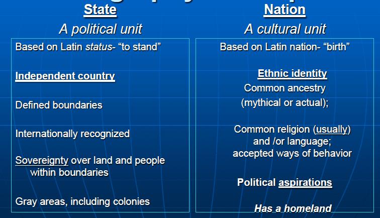
8 State, Nation, all the others.. Thursday, May 4, :03 PM State - occupies space with borders, political sovereignty, international recognition, has people (the countries below are all states) Slovakia Russian Empire Nation - people who share a common ethnicity, language, religion, history, etc. Examples: Kurds, Palestinians, Basque, Saamis Unit 4 Political Geography Page 8


9 Nation-state - ONE group who is also sovereign, France or Germany in previous years before immigration, closest today is Iceland or Japan Unit 4 Political Geography Page 9


10 Multi-National State - everywhere but perhaps Japan and Iceland, has a mix of people Iran Stateless Nation - there can be thousands of these, Native Americans are all stateless nations, no official borders or sovereignty, Palestine, Tibet, Basque are all examples, the largest stateless nation by population are the Kurds (30 million people spread in 6 countries. Unit 4 Political Geography Page 10


11 Multi State Nation - people with a shared culture and spread over several states, may need or want a nation at some point, examples are the Jewish people or the Koreas Unit 4 Political Geography Page 11


12 Unit 4 Political Geography Page 12

13 CREATE A FREE WEBSITE POWERED BY From < Unit 4 Political Geography Page 13


14 Centripetal vs. Centrifugal Forces Thursday, May 4, :05 PM Centripetal Forces - unify states, provide stability, strengthen the state, bind people together, create solidarity Unit 4 Political Geography Page 14
15 Centrifugal Forces - divide a country, can lead to Balkanization, connected to devolution Unit 4 Political Geography Page 15
16 Unit 4 Political Geography Page 16

17 Unit 4 Political Geography Page 17

18 From < Unit 4 Political Geography Page 18

19 Devolution Thursday, May 4, :06 PM DEVOLUTION: the transfer or delegation of power to a lower level, especially by central government to local or regional administration. EXAMPLES: Czechoslovakia - divided into Czech Republic and Slovakia, ethnic Yugoslavia - ethnic and religious, violent "ethnic cleansing", separate nations Balkanization Sri Lanka- Sinhalese (Buddhist) suppressed by Tamil (Hindu), violent Civil Wars Western China - Tibet & Uygher separatism, terrorism, ethnic United Kingdom - Scotland gets separate Parliament, allegiance to Queen questions Catalonia/Spain - ethnocultural, economic, Catalonia wants independence due to economic superiority Italy - North and South differences over economy and climate, Sardinia wants autonomy USA - Hawaii wants lost rights as a kingdom restored Crimea - Russia and Ukraine, mix of Russians and Ukrainians Brazil - economic difference, south wealthier Unit 4 Political Geography Page 19

 suppressed by Tamil (Hindu),")


20 Yugoslavia - ethnic and religious, violent "ethnic cleansing", seperate nations Balkanization Sri Lanka- Sinhalese (Buddhist) suppressed by Tamil (Hindu), violent Civi Western China - Tibet & Uygher seperatism, terrorism, ethnic Crimea - Russia and Ukraine, mix of Russians and Ukrainians Italy - North and South differences over economy and climate, Sardinia wants autonomy Catalonia/Spain - ethnocultural, economic, Catlaonia wants independence due to economic superiority Unit 4 Political Geography Page 20


21 Czechoslovakia - divided into Czech Republic and Slovakia, ethnic USA - Hawaii wants lost rights as a kingdom restored From < Unit 4 Political Geography Page 21

22 Unitary vs. Federal Systems Thursday, May 4, :07 PM Examples: US Canada Examples: France Federal State - An internal organization of a state that allocates most powers to units of local government. Unitary State -An internal organization of a state that places most power in the hands of central government officials. Unit 4 Political Geography Page 22


23 Power Distribution: Unitary, Confederation, and Federal Unit 4 Political Geography Page 23

24 From < Unit 4 Political Geography Page 24


25 Shapes of States Thursday, May 4, :08 PM Compact State: the distance from the geographic center of the area to any point on the boundary does not vary greatly, ie. Poland, Kenya Advantages: easier to manage with communication and transportation Prorupt/Protruded State: state having a portion of territory that is elongated, EX: Democratic Republic of Congo or Thailand Advantages: can give access to resources or easy to split Disadvantages: more likely to not be culturally assimilated, more borders to defend & communicate Elongated State: state that is geographically long and narrow, Ex: Chile, Italy Disadvantages: Lots of borders to protect, harder communication and more travel required, diverse climate, far from capital Unit 4 Political Geography Page 25

 Must")

26 Perforated State: state that totally surrounds another state Ex: South Africa & Lesotho, Italy and the Vatican Disadvantages: completely landlocked, must have everything cross through another country, possible hostilities Fragmented State: state split into many pieces Ex: Indonesia, Fuji, Denmark, Philippines Advantages: can have lots of resources Disadvantages: communication difficult, hard govern, difficult to create nationalism and assimilation Landlocked State: state not having direct access to an ocean (this is not a shape-just a condition) Must rely on other nations to send or receive goods, cannot maintain a navy, must worry about hostilities disrupting trade Microstate: state that is extremely small, ie. San Marino, Vatican City, Luxembourg, Liechtenstein From < Unit 4 Political Geography Page 26
27 Unit 4 Political Geography Page 27

28 Boundary Thursday, May 4, :10 PM Boundary a vertical plane that cuts through the rocks below and the airspace above, dividing one state territory from another Therefore, we aren t just talking about the signs we see that separate states; we are talking about airspace, water, minerals, resources, etc. Established a boundary includes four steps 1) States define the boundary through a legal document (by listing actual points in the landscape or by using latitude & longitude) 2) Cartographers delimit the boundary by drawing it on a map 3) States can demarcate it---marking the boundary(pillars, fences, walls, etc) 4) States must administrate it-determine how it will be maintained, how goods & people will cross it TYPES OF BOUNDARIES GEOMETRIC: Using latitude/longitude lines, township/range lines PHYSICAL-POLITICAL: Follow an agreed-upon feature in the geographic landscape (river, crest of a mountain range, sea, etc) ****With so many different boundaries, it leads to a situation where there are states with many different shapes Unit 4 Political Geography Page 28

")


29 Geometric by township lines Geometric by 49 Parallel Rio Grande is a physical-political boundary The Alps border France and Italy Another way to classify boundaries depends on how they were evolved Antecedent: existed before human cultures developed (example: a river) Examples:.Malaysia/Indonesia on the island of Borneo. The boundary passes through a mountainous, sparsely inhabited rainforest where there is a break in settlement. Himalayan Mts between China and India Pyrenees Mts between Spain and France Subsequent: settlement happens, then a boundary is drawn(example: U.S./Can. Border,) often from conflict China/Vietnam, Germany/Poland, Northern Ireland/Ireland Unit 4 Political Geography Page 29

 Unit 4 Political Geography")
30 Superimposed: forcibly put on a landscape by outsiders example: Israel border, North and South Korea Relict: no longer functions, but used to (example: Berlin Wall, Great Wall of China) Unit 4 Political Geography Page 30

31 Unit 4 Political Geography Page 31


32 Unit 4 Political Geography Page 32


33 boundary delimitation: The process in which cartographers put the boundaries on the map. boundary demarcation: physically marked with steel posts, concrete pillars, fences or another visible mean. From < Unit 4 Political Geography Page 33


34 Geopolitical Theories Thursday, May 4, :17 PM Unit 4 Political Geography Page 34
 and have room. Unit 4 Political Geography Page 35")
35 Do not forget Ratzel and organic theory that says the state is like an organism and therefore needs to "eat" (expand) and have room. Unit 4 Political Geography Page 35


36 Imperialism and Colonialism Influences Thursday, May 4, :21 PM Unit 4 Political Geography Page 36

37 Unit 4 Political Geography Page 37

38 Gerrymandering Thursday, May 4, :22 PM Unit 4 Political Geography Page 38
39 Unit 4 Political Geography Page 39
40 Supranationalism - 3 or more Thursday, May 4, :26 PM Unit 4 Political Geography Page 40
41 Unit 4 Political Geography Page 41

42 UN Law of the Sea Thursday, May 4, :27 PM Unit 4 Political Geography Page 42

43 Unit 4 Political Geography Page 43
Essential Knowledge. Independent states are the primary building blocks of the world. Independent states, world political map
 A. The contemporary political map has been shaped by events of the past. B. Spatial political patterns reflect ideas of territoriality and power Explain the structure of the contemporary Explain the evolution
Political Geography Unit Test: Multiple Choice
 1. In political geography, a state is a a) nation b) country c) city d) county Political Geography Unit Test: Multiple Choice 2. At the global scale, territories are considered states when they have a)
PLEASE DO NOT WRITE ON THIS TEST BOOKLET. MULTIPLE CHOICE. Choose the one alternative that best completes the statement or answers the question.
 Unit 4 Assessment - Political Geography PLEASE DO NOT WRITE ON THIS TEST BOOKLET MULTIPLE CHOICE. Choose the one alternative that best completes the statement or answers the question. 1) The world's largest
APHuG Vocabulary: Chapter 8 Political Geography
 APHuG Vocabulary: Chapter 8 Political Geography Directions: In the spaces provided, write a definition in your own words and identify a real-world (or reasonable potential real) example for each term.
Political Organizations of Space
 Political Organizations of Space Quiz Ferret!! Not natural Man Made Organization Study of human political organizations Organize Land Political organizations Political Structure 3 Levels Above Country
State politically organized territory recognized by the international community. Must contain
 Political Geography State politically organized territory recognized by the international community. Must contain» 1) a permanent population» 2) a defined territory,» 3) a functioning government and economic
Chapter 8: Political Geography. Unit 4
 Chapter 8: Political Geography Unit 4 Where Are States Distributed? Introducing political geography State an area organized into a political unit and ruled by an established government that has control
Political Geography Unit Test (Version B)
") Political Geography Unit Test (Version B) Figure 1 1. What shape BEST describes the country shown in Figure 1 above? a. elongated b. perforated c. prorupted d. compact e. fragmented Figure 2 2. What shape
Political Geography Unit Test (Version B) Figure 1 1. What shape BEST describes the country shown in Figure 1 above? a. elongated b. perforated c. prorupted d. compact e. fragmented Figure 2 2. What shape
Chapter 8.1 Assignment
 Advanced Placement Human Geography Chapter 8.1 Assignment Political Geography State Territory Territoriality Sovereignty Territorial Integrity Nation Nation-state Multistate Nation Multinational State
5 Shapes of Countries and Enclaves and Exclaves
 5 Shapes of Countries and Enclaves and Exclaves Definition - The boundaries of a country and the shape of the land that it encompasses can present problems or it can help unify the nation. Each shape of
History of the State
 History of the State What did we have before states? What were those entities borders like? Where is the hearth of the modern state concept? Timeline of the development of the state idea. Greek and Roman
Chapter 9: Political Geography
 Chapter 9: Political Geography Introduction to Geography Lehman College GEH 101/GEH 501 Spring 2011 Keith Miyake Political Geography Study of the organization and distribution of political phenomena, e.g.:
AP HUMAN GEOGRAPHY Unit 7: POLITICAL GEOGRAPHY (Ch.8)
") AP HUMAN GEOGRAPHY Unit 7: POLITICAL GEOGRAPHY (Ch.8) Political Geography The study of human political organization of the earth. Study political organization at three scales: Supranational (Organizations
AP HUMAN GEOGRAPHY Unit 7: POLITICAL GEOGRAPHY (Ch.8) Political Geography The study of human political organization of the earth. Study political organization at three scales: Supranational (Organizations
JANUARY 5, 2018 Prisoners of Geography Reading HW: Prisoners of Geography Reading Guide due Friday, Jan. 12 Story Map due Monday
 JANUARY 5, 2018 Prisoners of Geography Reading HW: Prisoners of Geography Reading Guide due Friday, Jan. 12 Story Map due Monday JANUARY 5, 2018 Get out stuff for notes Political Geography Intro Morphology
CHAPTER 8 POLITICAL GEOGRAPHY NOTES PART II
 CHAPTER 8 POLITICAL GEOGRAPHY NOTES PART II CENTRIPETAL AND CENTRIFUGAL FORCES Richard Hartshorne, a leading political geographer described Centripetal forces as things that bind or hold a nation together
Chapter 8: Political Geography
 Chapter 8: Political Geography EQ: How does political geography impact human activity? The Cultural Landscape: An Introduction to Human Geography Where Are States Located? Problems of defining states Almost
HUMAN GEOGRAPHY. By Brett Lucas
 HUMAN GEOGRAPHY By Brett Lucas POLITICAL GEOGRAPHY Overview States Nationalism National Boundaries U.S. Political Geography States Defining States Problems of defining states Korea: one state or two? China
Rubenstein s The Cultural Landscape Chapter 8: Political Geography
 Rubenstein s The Cultural Landscape Chapter 8: Political Geography Directions: The following worksheet accompanies your reading of the text. The key concepts and questions from the reading require bulleted
MULTIPLE CHOICE. Choose the one alternative that best completes the statement or answers the question.
 Chapter 8 Exam Name MULTIPLE CHOICE. Choose the one alternative that best completes the statement or answers the question. 1) Terrorism differs from assassinations and other acts of political violence
Political Geography. Chapter 8
 Political Geography Chapter 8 A World of States State An area organized into a political unit and ruled by an established government that has control over its internal and foreign affairs Sovereignty A
Chapter 8 Learning Guide Political Geography
 Chapter 8 Learning Guide Political Geography Key Issue 1 Where Are States Located? Pgs. 238 247 Problems of Defining States 1. Define state: 2. Define sovereignty: 3. There is some disagreement about how
INTRODUCING POLITICAL GEOGRAPHY
 Revised 2017 NAME: PERIOD: Rubenstein: The Cultural Landscape (12 th edition) Chapter Eight Political Geography (pages 264 thru 305) This is the primary means by which you will be taking notes this year
Political Geography: On the Map
 Political Geography: On the Map Get ready to create a map that will help you understand the development of states and borders across the globe. You will need a pen and several highlighters. Before you
2) Korea is a good example of a 2) A) sovereign state. B) colony. C) patron-state.
 Korea is a good example of a 2) A) sovereign state. B) colony. C) patron-state.") AP Test 8 Review Name MULTIPLE CHOICE. Choose the one alternative that best completes the statement or answers the question. 1) A state which places most power in the hands of a central government is a
AP Test 8 Review Name MULTIPLE CHOICE. Choose the one alternative that best completes the statement or answers the question. 1) A state which places most power in the hands of a central government is a
MULTINATIONALISM and the CHANGING POLITICAL LANDSCAPE
 MULTINATIONALISM and the CHANGING POLITICAL LANDSCAPE Devolution The movement of power from the central government to regional governments within the state. Ethnocultural Devolutionary Movements Nations
WINTER. March 24. Template
 March 24 WINTER EQ- What are the different state shapes and types of boundaries? Agenda: 1. Daily Sheet 2. Review 3. Nation, State, Nation-States Gallery walk 4. Types of Boundaries Notes 4. Shapes of
language religion and ethnicity nationalism
 Political Geography Internal Politics Centripetal forces vs. Attitude or force that unifies and enhances support for state a single native language or a colonial official language English in India, Nigeria
Chapter 8 Political Geography
 Chapter 8 Political Geography 1) Conflicting claims to the Arctic are mostly due to A) the potential for energy resources. 2) The most populous country that is not a member of the United Nations is A)
Political Geography. What is a state? Development of the State Concept. Development of the State Concept. Problematic States. Problematic States
 What is a state? Political Geography A region on the earth that has: Defined territory Population Political structure Sovereignty country is synonymous with state nation is synonymous with ethnicity Development
Chapter 8 Political Geography Pearson Education, Inc.
 Chapter 8 Political Geography Political Geography: Key Issues 1. Where Are States Distributed? 2. Why Are Nation-States Difficult to Create? 3. Why Do Boundaries Cause Problems? 4. Where Do States Face
Political Geography. Chapter 8
 Political Geography Chapter 8 Where Are States Distributed? State Area organized into a political unit and ruled by an established gov t that has control over its internal and foreign affairs Occupies
The Cultural Landscape Eleventh Edition
 Chapter 8 Lecture The Cultural Landscape Eleventh Edition Political Geography Matthew Cartlidge University of Nebraska-Lincoln Key Issues Where are states distributed? Why are nation-states difficult to
VISA POLICY OF THE REPUBLIC OF KAZAKHSTAN
 VISA POLICY OF THE REPUBLIC OF KAZAKHSTAN Country Diplomatic Service National Term of visafree stay CIS countries 1 Azerbaijan visa-free visa-free visa-free 30 days 2 Kyrgyzstan visa-free visa-free visa-free
Key Concepts & Resources
 Unit Plan Unit IV-Political Organization of Space Description of Unit (Source: AP Human Geography Course Description) This section of the course introduces students to the nature and significance of the
APHUG Chapter 8: Political Geography p.238
 P a g e 1 APHUG Chapter 8: Political Geography p.238 KI 1-4 Name Key Issues 1: Where Are States Located? 2: Why Do Boundaries Between States Cause Problems? 3: Why Do States Cooperate with Each Other?
UNIT 4: POLITICAL GEOGRAPHY by Dan Snyder
 UNIT 4: POLITICAL GEOGRAPHY by Dan Snyder Chapter Outlines Chapter 14 Chapter 15 Chapter 16 Chapter 17 Key Concepts [A] Territorial Dimensions of Politics [B] Evolution of the Contemporary Political Pattern
Chapter 8: Political Geography
 Chapter 8: Political Geography Concept Caching: Burma, Myanmar Barbara Weightman Copyright Field Note: Independence Is Better than Servitude I arrived in Ghana just after an assassination attempt on the
Where is Europe located?
 Where is Europe located? Where in the world is Europe? How does Texas compare to Europe? How does the U.S. compare to Europe? Albania Andorra Austria Belarus Belgium Bosnia and Herzegovina Bulgaria Croatia
6. Identify the reason for which membership in the UN grew significantly in each of the following periods.
 Due: Thursday. January 8 Last Chance: Friday, January 9 th Key Issue 1: Where Are States Distributed? Pages 260-267 1. Define state: Name: Period: 2. Define sovereignty: 3. List the 6 largest states in
Key Issue 1: Where Are States Distributed? (Pages )
") Key Issue 1: Where Are States Distributed? (Pages 266-269) 1. Define state: 2. List the 6 largest states in order. 3. How many microstates are recognized? What do many have in common? List 6 that you can
Key Issue 1: Where Are States Distributed? (Pages 266-269) 1. Define state: 2. List the 6 largest states in order. 3. How many microstates are recognized? What do many have in common? List 6 that you can
UNGEGN World Geographical Names Database: an update
 UNITED NATIONS GROUP OF EXPERTS WORKING PAPER ON GEOGRAPHICAL NAMES NO. 21/9 Twenty-ninth session Bangkok, Thailand, 25 29 April 2016 Item 9 of the Provisional Agenda Activities Relating to the Working
Mapping physical therapy research
 Mapping physical therapy research Supplement Johan Larsson Skåne University Hospital, Revingevägen 2, 247 31 Södra Sandby, Sweden January 26, 2017 Contents 1 Additional maps of Europe, North and South
Key Issue 1: Where Are States Distributed?
 Key Issue 1: Where Are States Distributed? Pages 260-267 ***Always keep your key term packet out whenever you take notes from Rubenstein. As the terms come up in the text, think through the significance
1994 No PATENTS
 1994 No. 3220 PATENTS The Patents (Convention Countries) Order 1994 Made 14th December 1994 Laid before Parliament 23rd December 1994 Coming into force 13th January 1995 At the Court at Buckingham Palace,
Chapter 8 Political Geography
 Chapter 8 Political Geography 1) Conflicting claims to the Arctic are mostly due to A) the potential for energy resources. B) old Cold War grudges. C) colonial expansion. D) shifting sea ice formations.
Using your Cold War packet as a resource, follow the directions and complete the Postwar Soviet Expansion packet. Due at the end of the period.
 ASh CP and Honors Name: Mr. Bossio Period: Date: Postwar Soviet Expansion: Imperialism or SelfDefense? Objective: To understand possible explanations for Soviet expansion in the immediate postwar period.
Chapter 8 Political Geography Key Issue 1: Where Are States Distributed? [Pages ] DUE: FRI. JAN 12
![Chapter 8 Political Geography Key Issue 1: Where Are States Distributed? [Pages ] DUE: FRI. JAN 12](/thumbs/96/126774184.jpg "Chapter 8 Political Geography Key Issue 1: Where Are States Distributed? [Pages ] DUE: FRI. JAN 12") Name: Chapter 8 Political Geography Key Issue 1: Where Are States Distributed? [Pages 260-267] DUE: FRI. JAN 12 1. List the 6 largest states in order. 2. How many microstates are recognized? 3. What do
Name: Chapter 8 Political Geography Key Issue 1: Where Are States Distributed? [Pages 260-267] DUE: FRI. JAN 12 1. List the 6 largest states in order. 2. How many microstates are recognized? 3. What do
1994 No DESIGNS
 1994 No. 3219 DESIGNS The Designs (Convention Countries) Order 1994 Made 14th December 1994 Coming into force 13th January 1995 At the Court at Buckingham Palace, the 14th day of December 1994 Present,
Chapter 8. Political Geography
 Chapter 8 Political Geography Key Issue #1 Where are states located? Defining States & Development of the State Concept Problems of defining states Korea: one state or two? China & Taiwan: one state or
South Africa - A publisher s perspective. STM/PASA conference 11 June, 2012, Cape Town Mayur Amin, SVP Research & Academic Relations
 South Africa - A publisher s perspective STM/PASA conference 11 June, 2012, Cape Town Mayur Amin, SVP Research & Academic Relations 0 As a science information company, we have a unique vantage point on
International Influence
 What is influence? Influence is how a thing or person affects another thing or person. When someone has influence over you, he or she has the power to change the decisions you make. You can think about
List of Main Imports to the United States
 Example List 1 CANADA CHINA JAPAN MEXICO List 1 ARGENTINA AUSTRALIA BELGIUM COSTA RICA COTE D IVOIRE KUWAIT NORWAY SOUTH KOREA SRI LANKA SUDAN List 2 BRAZIL DOMINICAN REPUBLIC FRANCE NEW ZEALAND QATAR
International investment resumes retreat
 FDI IN FIGURES October 213 International investment resumes retreat 213 FDI flows fall back to crisis levels Preliminary data for 213 show that global FDI activity declined by 28% (to USD 256 billion)
The statistical regions of Europe as delineated by the United Nations as: Northern, Western,
 Regional Economy Paper: Geography The statistical regions of Europe as delineated by the United Nations as: Northern, Western, Eastern and Southern Europe. Western Europe has a long history of trade, free
FRQs Unit Question 1: Redistricting and Gerrymandering Question 2: Legacy of Colonialism
 2015 - Question 1: Redistricting and Gerrymandering FRQs Unit 4 2014 - Question 2: Legacy of Colonialism 2012 - Question 1: Border Walls and Barriers 2010 - Question 2: National Identity 2005 - Question
Section A: Europe: countries and borders
 Chapter 2: Europe Section A: Europe: countries and borders 1. There is only one correct answer for each of these multi choice questions (7 marks) What percentage of the world s land does Europe occupy?
FAQ 7: Why Origins totals and percentages differs from ONS country of birth statistics
 FAQ 7: Why totals and percentages differs from ONS country statistics 7 December 2016 Purpose of Information Note When the numbers and percentages of names by are compared with the numbers and percentages
Nations: Borders & Power
 Nations: Borders & Power What factors determine where boundaries between countries are established? How do different countries related to one another? Political Regions Governments establish boundaries
KINGDOM OF CAMBODIA NATION RELIGION KING 3 TOURISM STATISTICS REPORT. September 2010
 KINGDOM OF CAMBODIA NATION RELIGION KING 3 TOURISM STATISTICS REPORT September 2010 MINISTRY OF TOURISM Statistics and Tourism Information Department No. A3, Street 169, Sangkat Veal Vong, Khan 7 Makara,
Why Do Boundaries Cause Problems?
 276 THE CULTURAL LANDSCAPE KEY,ISSUE 3 Why Do Boundaries Cause Problems? Types of Boundaries Shapes of States Governing States Electoral Geography Learning Outcome 8.3.1 "';;0:,.;' Describe the,type~qf
Your Questions Answered
 Your Questions Answered Things you Requested. United Nations Law of the Sea Feng Shui Cape Cod Blockbusting and Racial Steering 4 Asian Tigers Exclusive Economic Zone Domino Theory Colonial Powers Ozone
Tourism Highlights International Tourist Arrivals, Average Length of Stay, Hotels Occupancy & Tourism Receipts Years
 KINGDOM OF CAMBODIAA NATION RELIGION KING 3 TOURISM STATISTICS REPORT Oct tober 2013 MINISTRY OF TOURISM Statisticss and Tourism Information Department No. A3, Street 169, Sangkat Veal Vong, Khann 7 Makara,
The National Police Immigration Service (NPIS) forcibly returned 412 persons in December 2017, and 166 of these were convicted offenders.
 forcibly returned 412 persons in December 2017, and 166 of these were convicted offenders.") Monthly statistics December 2017: Forced returns from Norway The National Police Immigration Service (NPIS) forcibly returned 412 persons in December 2017, and 166 of these were convicted offenders. The
Monthly statistics December 2017: Forced returns from Norway The National Police Immigration Service (NPIS) forcibly returned 412 persons in December 2017, and 166 of these were convicted offenders. The
International Influence STEP BY STEP
 Teacher s Guide Time Needed: One Class Period Materials Needed: Student worksheets, an overhead transparency, and an overhead or computer projector. Copy Instructions: Students will receive one reading
World Map Title Name. Russia. United States. Japan. Mexico. Philippines Nigeria. Brazil. Indonesia. Germany United Kingdom. Canada
 214 P Gersmehl Teachers may copy for use in their classrooms. Contact pgersmehl@gmail.com regarding permission for any other use. World Map Title Name Canada United States Mexico Colombia Ecuador Haiti
Education Quality and Economic Development
 Education Quality and Economic Development Eric A. Hanushek Stanford University Bank of Israel Jerusalem, June 2017 Sustainable Development Goals (SDGs) Development = Growth Growth = Skills Conclusions
Translation from Norwegian
 Statistics for May 2018 Forced returns from Norway The National Police Immigration Service (NPIS) forcibly returned 402 persons in May 2018, and 156 of these were convicted offenders. The NPIS is responsible
icd - institute for cultural diplomacy
 An International Conference on Peacebuilding, Reconciliation and Globalization in an Interdependent World An International Conference on Peacebuilding, Reconciliation and Globalization in an Interdependent
SKILLS, MOBILITY, AND GROWTH
 SKILLS, MOBILITY, AND GROWTH Eric Hanushek Ludger Woessmann Ninth Biennial Federal Reserve System Community Development Research Conference April 2-3, 2015 Washington, DC Commitment to Achievement Growth
GLOBAL RISKS OF CONCERN TO BUSINESS WEF EXECUTIVE OPINION SURVEY RESULTS SEPTEMBER 2017
 GLOBAL RISKS OF CONCERN TO BUSINESS WEF EXECUTIVE OPINION SURVEY RESULTS SEPTEMBER 2017 GLOBAL RISKS OF CONCERN TO BUSINESS Results from the World Economic Forum Executive Opinion Survey 2017 Survey and
KINGDOM OF CAMBODIA NATION RELIGION KING 3 TOURISM STATISTICS REPORT. March 2010
 KINGDOM OF CAMBODIA NATION RELIGION KING 3 TOURISM STATISTICS REPORT March 2010 MINISTRY OF TOURISM Statistics and Tourism Information Department No. A3, Street 169, Sangkat Veal Vong, Khan 7 Makara, Phnom
UAE E Visa Information
 UAE E Visa Information Visas on arrival (A) If you are a passport holder of the below country or territory, no advance visa arrangements are required to visit the UAE. Simply disembark your flight at Dubai
VOICE AND DATA INTERNATIONAL
 INTERNATIONAL VOICE AND DATA Find the EE international rates, as well as the new roaming bundles for and. INTERNATIONAL VOICE AND DATA p.28-32 International Voice p.29-30 International Data p.31-32 contents
The EU on the move: A Japanese view
 The EU on the move: A Japanese view H.E. Mr. Kazuo KODAMA Ambassador of Japan to the EU Brussels, 06 February 2018 I. The Japan-EU EPA Table of Contents 1. World GDP by Country (2016) 2. Share of Japan
Russian Federation. OECD average. Portugal. United States. Estonia. New Zealand. Slovak Republic. Latvia. Poland
 INDICATOR TRANSITION FROM EDUCATION TO WORK: WHERE ARE TODAY S YOUTH? On average across OECD countries, 6 of -19 year-olds are neither employed nor in education or training (NEET), and this percentage
The Madrid System. Overview and Trends. Mexico March 23-24, David Muls Senior Director Madrid Registry
 The Madrid System Overview and Trends David Muls Senior Director Madrid Registry Mexico March 23-24, 2015 What is the Madrid System? A centralized filing and management procedure A one-stop shop for trademark
QGIS.org - Donations and Sponsorship Analysis 2016
 QGIS.org - Donations and Sponsorship Analysis 2016 QGIS.ORG received 1128 donations and 47 sponsorships. This equals to >3 donations every day and almost one new or renewed sponsorship every week. The
BULGARIAN TRADE WITH EU IN JANUARY 2017 (PRELIMINARY DATA)
") BULGARIAN TRADE WITH EU IN JANUARY 2017 (PRELIMINARY DATA) In January 2017 Bulgarian exports to the EU increased by 7.2% month of 2016 and amounted to 2 426.0 Million BGN (Annex, Table 1 and 2). Main trade
BULGARIAN TRADE WITH EU IN JANUARY 2017 (PRELIMINARY DATA) In January 2017 Bulgarian exports to the EU increased by 7.2% month of 2016 and amounted to 2 426.0 Million BGN (Annex, Table 1 and 2). Main trade
Return of convicted offenders
 Monthly statistics December : Forced returns from Norway The National Police Immigration Service (NPIS) forcibly returned 869 persons in December, and 173 of these were convicted offenders. The NPIS forcibly
BULGARIAN TRADE WITH EU IN THE PERIOD JANUARY - MARCH 2016 (PRELIMINARY DATA)
") BULGARIAN TRADE WITH EU IN THE PERIOD JANUARY - MARCH 2016 (PRELIMINARY DATA) In the period January - March 2016 Bulgarian exports to the EU grew by 2.6% in comparison with the same 2015 and amounted to
BULGARIAN TRADE WITH EU IN THE PERIOD JANUARY - MARCH 2016 (PRELIMINARY DATA) In the period January - March 2016 Bulgarian exports to the EU grew by 2.6% in comparison with the same 2015 and amounted to
AUSTRALIA S REFUGEE RESPONSE NOT THE MOST GENEROUS BUT IN TOP 25
 19 July 2013 AUSTRALIA S REFUGEE RESPONSE NOT THE MOST GENEROUS BUT IN TOP 25 Australia is not the world s most generous country in its response to refugees but is just inside the top 25, according to
How many students study abroad and where do they go?
 1. EDUCATION LEVELS AND STUDENT NUMBERS How many students study abroad and where do they go? More than 4.1 million tertiary-level students were enrolled outside their country of citizenship in 2010. Australia,
geography Bingo Instructions
 Bingo Instructions Host Instructions: Decide when to start and select your goal(s) Designate a judge to announce events Cross off events from the list below when announced Goals: First to get any line
MIGRATION IN SPAIN. "Facebook or face to face? A multicultural exploration of the positive and negative impacts of
 "Facebook or face to face? A multicultural exploration of the positive and negative impacts of Science and technology on 21st century society". MIGRATION IN SPAIN María Maldonado Ortega Yunkai Lin Gerardo
Contemporary theory, practice and cases By Ilan Alon, Eugene Jaffe, Christiane Prange & Donata Vianelli
 Global Marketing Contemporary theory, practice and cases By Ilan Alon, Eugene Jaffe, Christiane Prange & Donata Vianelli Chapter 3 Regional Trade and Emerging Markets Learning objectives After reading
PROTOCOL RELATING TO AN AMENDMENT TO THE CONVENTION ON INTERNATIONAL CIVIL AVIATION ARTICLE 45, SIGNED AT MONTREAL ON 14 JUNE parties.
 PROTOCOL RELATING TO AN AMENDMENT TO THE CONVENTION ON INTERNATIONAL CIVIL AVIATION ARTICLE 45, SIGNED AT MONTREAL ON 14 JUNE 1954 State Entry into force: The Protocol entered into force on 16 May 1958.
Global Harmonisation of Automotive Lighting Regulations
 Transmitted by the expert from GTB Informal document GRE-68-10 (68th GRE, 16-18 October 2012) agenda item 19(a)) Global Harmonisation of Automotive Lighting Regulations This discussion document has been
OECD Strategic Education Governance A perspective for Scotland. Claire Shewbridge 25 October 2017 Edinburgh
 OECD Strategic Education Governance A perspective for Scotland Claire Shewbridge 25 October 2017 Edinburgh CERI overview What CERI does Generate forward-looking research analyses and syntheses Identify
2014 BELGIAN FOREIGN TRADE
 2014 BELGIAN FOREIGN TRADE 2 3 01 \\ EXPORTS 6 1.1 Geographical developments 1.2 Sectoral developments 02 \\ IMPORTS 14 2.1 Geographical developments 2.2 Sectoral developments 03 \\ GEOGRAPHICAL TRADE
HUMAN RESOURCES IN R&D
 HUMAN RESOURCES IN R&D This fact sheet presents the latest UIS S&T data available as of July 2011. Regional density of researchers and their field of employment UIS Fact Sheet, August 2011, No. 13 In the
Contributions to UNHCR For Budget Year 2014 As at 31 December 2014
 1 UNITED STATES OF AMERICA 1,280,827,870 2 EUROPEAN UNION 271,511,802 3 UNITED KINGDOM 4 JAPAN 5 GERMANY 6 SWEDEN 7 KUWAIT 8 SAUDI ARABIA *** 203,507,919 181,612,466 139,497,612 134,235,153 104,356,762
1. Why do third-country audit entities have to register with authorities in Member States?
 Frequently Asked Questions (FAQ) Form A Annex to the Common Application Form for Registration of Third-Country Audit Entities under a European Commission Decision 2008/627/EC of 29 July 2008 on transitional
Industrial Remote Communication Country Approvals for mobile network based Products
 SIMATIC NET Industrial Remote Communication Country Approvals for mobile network based Products 2018-01-12 www.siemens.com/simatic-net Industrial Routers / Modems CP 1200 LOGO! CMR Compact RTU MD741-1
China s Aid Approaches in the Changing International Aid Architecture
 China s Aid Approaches in the Changing International Aid Architecture Mao Xiaojing Deputy Director, Associate Research Fellow Chinese Academy of International Trade and Economic Cooperation (CAITEC) MOFCOM,
States & Types of States
 States & Types of States Political Geography Nation: a group of people with a common culture - Tightly knit group of people possessing shared cultural beliefs & unity: genous - Ancestry or historical events
Contracting Parties to the Ramsar Convention
 Contracting Parties to the Ramsar Convention 14/12/2016 Number of Contracting Parties: 169 Country Entry into force Notes Albania 29.02.1996 Algeria 04.03.1984 Andorra 23.11.2012 Antigua and Barbuda 02.10.2005
Circular of Supreme People's Court on Implementing Convention on the Recognition and Enforcement of Foreign Arbitral Awards Entered by China
 Circular of Supreme People's Court on Implementing Convention on the Recognition and Enforcement of Foreign Arbitral Awards Entered by China All Higher People's Courts and Intermediate People's Courts
Shaping the Future of Transport
 Shaping the Future of Transport Welcome to the International Transport Forum Over 50 Ministers Shaping the transport policy agenda The International Transport Forum is a strategic think tank for the transport
Comparing the Wealth of Nations. Emily Lin
 Comparing the Wealth of Nations Emily Lin What is HDI? What is GDP? What are some of the ways to rank countries economically? Developed vs Developing vs Least Developed GDP GDP per Capita Each method has
The High Cost of Low Educational Performance. Eric A. Hanushek Ludger Woessmann
 The High Cost of Low Educational Performance Eric A. Hanushek Ludger Woessmann Key Questions Does it matter what students know? How well is the United States doing? What can be done to change things? Answers