MEETING NOTICE AND AGENDA
|
|
|
- Amice Crawford
- 5 years ago
- Views:
Transcription
1 MEETING NOTICE AND AGENDA COMMITTEE ON BINATIONAL REGIONAL OPPORTUNITIES (COBRO) The Committee on Binational Regional Opportunities (COBRO) may take action on any item appearing on this agenda. Tuesday, April 1, :00 to 4:30 p.m. SANDAG, 7 th Floor Conference Room 401 B Street, Suite 800 San Diego, CA Staff Contact: Hector Vanegas (619) hva@sandag.org AGENDA HIGHLIGHTS APPOINTMENT OF MEMBERS TO REPRESENT COBRO AT THE JOINT MEETING WITH THE BORDERS COMMITTEE AND THE CITY OF TIJUANA ON FRIDAY, APRIL 25, 2008 BRIEFING ON THE SAN YSIDRO MOBILITY PLAN - PHASE 1 PROGRESS PRESENTATION ON DISTINCTIVE PROJECTS COMPANY (DPC) - BROWN FIELD'S PROPOSAL TO REDEVELOP BROWN FIELD AIRPORT MISSION STATEMENT The Committee on Binational Regional Opportunities (COBRO) will advise the Borders Committee of the San Diego Association of Governments (SANDAG) concerning both short- and long-term binational related activities, Issues, and actions; provide input regarding binational border-related planning and development; and identify ways to assist and coordinate with existing efforts in the binational area. The COBRO will serve as a working group to the SANDAG Borders Committee to facilitate a better understanding of the binational border-related issues and needs of the California-Baja California region.

2 Welcome to SANDAG! Members of the public may speak to the COBRO on any item at the time that the Committee is considering the item. Please complete a Speaker s Slip which is located in the rear of the room and then present the slip to Committee staff. Also, members of the public are invited to address the Committee on any issue under the agenda item entitled Public Comments/Communications. Speakers are limited to three minutes. The COBRO may take action on any item appearing on the agenda. This agenda and related staff reports can be accessed at under meetings on SANDAG s Web site. Public comments regarding the agenda can be forwarded to SANDAG via the comment form also available on the Web site. comments should be received no later than noon, two days prior to the COBRO meeting. In compliance with the Americans with Disabilities Act (ADA), SANDAG will accommodate persons who require assistance in order to participate in SANDAG meetings. If such assistance is required, please contact SANDAG at (619) in advance of the meeting. To request this document or related reports in an alternative format, please call (619) , (619) (TTY), or fax (619) SANDAG offices are accessible by public transit. Phone COMMUTE or see for route information. 2
3 COMMITTEE ON BINATIONAL REGIONAL OPPORTUNITIES Tuesday, April 1, 2008 ITEM # RECOMMENDATION 1. WELCOME AND INTRODUCTIONS +2. COMMITTEE ON BINATIONAL REGIONAL OPPORTUNITIES (COBRO) SUMMARY OF MARCH 4, 2008, MEETING APPROVE Summary of March 4, 2008, meeting. 3. PUBLIC COMMENTS/COMMUNICATIONS AND MEMBER COMMENTS INFORMATION Each speaker is limited to three minutes. CONSENT REPORTS (4 through 5) +4. UPCOMING EVENTS INFORMATION +5. SANDAG S BINATIONAL ANNUAL EVENT (Hector Vanegas, SANDAG) ACCEPT To advance strategies identified in the Otay Mesa-Mesa de Otay Binational Corridor Strategic Plan, staff recommends that the Mobile Seminar be held on June 3, This recommendation will be presented to the Borders Committee. CHAIR S REPORTS 6. APPOINTMENT OF MEMBERS TO REPRESENT COBRO AT THE JOINT MEETING OF THE BORDERS COMMITTEE AND THE CITY OF TIJUANA ON FRIDAY, APRIL 25, 2008 APPOINT To follow up on the implementation of the Otay Mesa-Mesa de Otay Binational Corridor Strategic Plan, on Friday, April 25, 2008, the Borders Committee and COBRO will hold a joint meeting with their counterparts of the City of Tijuana. COBRO is asked to appoint representatives to be seated at the table, although all members are invited to participate. 3
4 ITEM # RECOMMENDATION REPORT ITEMS (7 through 9) +7. UPDATES TO THE BINATIONAL CONTACTS GUIDE (Hector Vanegas, SANDAG) INFORMATION The Binational Contacts Guide was updated and now reflects a new section for border government agencies. Also, BorderBase.org has been redirected to this guide. +8. BRIEFING ON THE SAN YSIDRO MOBILITY PLAN - PHASE 1 PROGRESS (Steve Otto, San Ysidro Transportation Collaborative) INFORMATION This report will present an overview of the San Ysidro Mobility Plan and an update on its progress since the summer of PRESENTATION ON DISTINCTIVE PROJECTS COMPANY (DPC) - BROWN FIELD S PROPOSAL TO REDEVELOP BROWN FIELD AIRPORT (S. Wayne Rosenbaum and Nici Boon, DPC Brown Field) INFORMATION The City of San Diego s Land Use and Housing Committee selected DPC-Brown Field in January 2008 to negotiate with the City of San Diego staff on a development lease for various locations in Brown Field Airport. DPC-Brown Field will provide an informational overview on their plans to redevelop Brown Field. 10. NEXT MEETING DATE AND LOCATION INFORMATION The next meeting of the Committee on Binational Regional Opportunities will be a Joint Meeting with the Borders Committee and the City of Tijuana on Friday, April 25, 2008, from 12:30 to 2:30 p.m., at SANDAG. Please note that the scheduled meeting on Tuesday, May 5, 2008, will be cancelled. + next to an item indicates an attachment 4
5 San Diego Association of Governments COMMITTEE ON BINATIONAL REGIONAL OPPORTUNITIES April 1, 2008 AGENDA ITEM NO.: 2 Action Requested: APPROVE COMMITTEE ON BINATIONAL REGIONAL OPPORTUNITIES (COBRO) SUMMARY OF MARCH 4, 2008, MEETING WELCOME AND INTRODUCTIONS The March 4, 2008, Committee on Binational Regional Opportunities (COBRO) meeting was called to order by Co-Chair Consul General María de los Remedios Gómez-Arnau. The meeting was held at the Palacio Municipal de Tijuana. Lórena Flores and Luis Bustamante, City of Tijuana, formally welcomed COBRO members to the City of Tijuana. Members present were: Co Chair Consul General María de los Remedios Gómez-Arnau, Consul General of Mexico in San Diego; Wilfrido Ruiz, South County Economic Development Council; Sergio Pallares, Caltrans; Lorena Flores, City of Tijuana; Megan Jones, County of San Diego; Juan Manuel Rodriguez, Colegio de la Frontera Norte (COLEF); Claudia Basurto and Toñe Béguerisse, Fundación Internacional de la Comunidad, A.C.; Luis Duarte, IMPlan; Tatiana Suro, Otay Mesa Chamber of Commerce; Angelika Villagrana and James Clark, San Diego Regional Chamber of Commerce; Thomas Currie and Jason MB Wells, San Ysidro Chamber of Commerce; Oscar Romo, Tijuana River National Estuarine Research Reserve (TRNERR); Carlos Lopez, State of Baja California; Advisory members present: Amy Radetsky, U.S. Consulate in Tijuana; Angelica Suarez, Southwestern Community College; and Héctor Vanegas, Ron Saenz, and Elisa Arias, SANDAG staff. MEETING SUMMARY On behalf of Elsa Saxod, Saxod Enterprises, Hector Vanegas, SANDAG, presented two changes to the February 5, 2007, meeting summary. On page six, under item 10, Ms. Saxod requested that Rancho La Puerta be changed to Fundacion La Puerta. In the fifth paragraph under the same agenda item, Ms. Saxod requested that the following sentence be changed from: Ms. Saxod stated that she is concerned that toll roads and customs fees are being discussed as the solution because local residents are subsidizing the goods and services that benefit the entire country, to Ms. Saxod stated that she is concerned that toll roads and customs fees are being discussed as the solution causing local residents to subsidize the goods and services that benefit the entire country. Sergio Pallares, Caltrans, entertained a motion to approve the February 5, 2008, meeting summary with the changes proposed by Elsa Saxod. Angelika Villagrana, San Diego Regional Chamber of Commerce (SDRCC), seconded the motion. The meeting summary was approved. 5
6 PUBLIC COMMENTS/COMMUNICATIONS AND MEMBER COMMENTS Angelika Villagrana, (SDRCC), provided COBRO members with a letter summarizing the recommendations for improving border wait times that were developed at the United States- Mexico Border Efficiency Conference on February 8, The letter was sent to Mexico s Secretary of the Economy and Secretary of State, as well as the U.S. Department of Commerce and the Department of Homeland Security. A copy of the letter is available upon request. Olivia Maldonado announced that the Secretary of the Economy would submit a request to become a member of COBRO. UPCOMING EVENTS Consul General Gómez-Arnau referred members to the upcoming events attachment in their agenda packets. PRESENTATION ON THE STATEMENT OF INTENT BETWEEN THE CITIES OF SAN DIEGO AND TIJUANA Jason MB Wells, San Ysidro Chamber of Commerce, introduced Lorena Flores, City of Tijuana, to present the Statement of Intent signed jointly by Mayor Sanders, City of San Diego, and Mayor Jorge Ramos, City of Tijuana at the San Ysidro Chamber of Commerce annual gala on February 1, The purpose of the statement is to demonstrate that improving border wait times at the San Diego Tijuana Ports of Entry is a priority for both administrations. The Mayors agreed that they will work with existing binational groups, like COBRO, to facilitate border planning efforts. A copy of the agreement was provided in the agenda packet. Consul General Gómez-Arnau announced that she also recognizes the importance of efficient border crossings and is organizing a Border Liaison Mechanism meeting with the U.S. Consul General in Tijuana to prepare a similar joint declaration demonstrating their support for improving border wait times. This declaration will be sent to Mexico City later this year. PRESENTATION ON ECONOMIC AND INDUSTRIAL GROWTH IN TIJUANA A copy of this presentation is available upon request. Arturo Montfort, Desarrollo Económico Industrial de Tijuana, A.C. (DEITAC), gave an overview on DEITAC s economic development work in the City of Tijuana. DEITAC is a non-profit business organization dedicated to promoting and retaining industrial investment in the Tijuana San Diego region. For the past 18 years, DEITAC has been providing support to help existing businesses grow while working to attract new business investment to the region. They currently have 128 members from 24 different business sectors. The main activities of DEITAC include the promotion of Tijuana to potential businesses and investors, business expansion and retention programs, the collection and dissemination of demographic, real-estate and socio-economic information on the Tijuana region, workforce development, and advocacy for businesses. DEITAC works in partnership with government agencies in Mexico at the local, state, and federal levels, as well as with agencies in San Diego such as SANDAG, the Otay Mesa Chamber of Commerce, and the South County Economic Development Council. 6
7 Recent studies demonstrated that Tijuana is most competitive in the following business clusters: automotive, metal mechanics, medical devices, and hi-tech electronics. DEITAC s current promotional efforts are targeting these primary business sectors. Sergio Pallares, Caltrans, asked if there was an association of Chambers of Commerce that is focused specifically on the economic development of border regions. Mr. Montfort responded that the International Economic Development Corporation is a group comprised of economic development organizations worldwide, but that there is not specifically an association of chambers. Hector Vanegas stated that there is also the Border Trade Alliance. Mr. Pallares responded that this was an association of industries not an association of chambers. Mr. Montfort stated that with regards to economic development, we compete with other border regions so an association of border chambers of commerce would not necessarily be beneficial. Mr. Pallares announced that the economic development table at the Border Governors Conference recommended the creation of an Intranet for crossborder business networking. Angelika Villagrana explained that the San Diego Dialogue was working on creating a clean-tech business cluster in the border region and asked if DEITAC was working to recruit clean-tech businesses to the region. Mr. Montfort confirmed that they were working on clean-tech development. James Clark, San Diego Regional Chamber of Commerce, stated that on April 1 at 11 p.m. there will be a Clean-Tech San Diego meeting at Birch Aquarium. Mayor Sanders and Supervisor Cox invited Mayor Ramos to attend this meeting to start discussing the creation of a San Diego Tijuana cleantech corridor. Consul General Gómez-Arnau stated that she was pleased to see such strong binational partnerships in the region and that this level of collaboration does not occur in other areas throughout the country. PRESENTATION ON TRANSBORDER MANAGEMENT AND LOCAL DEVELOPMENT IN NORTHERN MEXICO Dr. José María Ramos García, El Colegio de la Frontera Norte (COLEF), presented his research project titled, The Capacities of Transborder Management and Local Development in Northern Mexico. The research is currently underway in partnership with academic institutes in Baja California, Monterey, California, and Washington D.C. Four areas have been selected as case studies: Tijuana-San Diego, Ciudad Juarez-El Paso, Laredo Nuevo Laredo, and Mexicali-Calexico. The report will cover two focus areas that are interrelated: national and local security, and local and social development. The purpose of the report is to identify opportunities and challenges within the context of these focus areas and make recommendations for capitalizing on the opportunities and challenges through the development of binational strategic plans. 7
8 With regard to public safety, the border municipalities face major issues on three levels: transborder safety, transnational safety (terrorism), and local public safety. Frequently, policy developed to address these issues does not consider local development. For example, U.S. Homeland Security policy has seriously impacted border wait times and as a result, economic development has slowed. Although these issues are shared, there are distinct differences between the municipality s capacity to manage these issues and the management methods utilized. In order for the border regions to continue to develop and remain competitive in the future, both public safety and local development will need to be integrated and addressed collaboratively and strategically. A summary of the research project was provided in the agenda packet. Consul General Gómez-Arnau stated that this was a very important topic for the San Diego Tijuana region and that a pilot project related to this issue should be considered by COBRO. Elisa Arias, SANDAG, explained that the Otay Mesa Mesa de Otay strategic plan is an example of a binational strategic plan developed jointly by SANDAG and IMPlan in cooperation with Secretaria de Infrastructura y Desarrollo Urbano Estatal/Secretary of State Infrastructure and Urban Development (SIDUE) and Caltrans. Sergio Pallares, Caltrans, stated that the California Baja California Border Master Plan is another example of a Binational plan currently being developed jointly by SIDUE and Caltrans. The Border Master Plan is 75 percent complete. With support from the SANDAG Service Bureau, the Border Master Plan working group created a methodology for prioritizing projects in the border region. Antonio Tapia, CANACO, stated that public safety and development issues are a direct result of the lack of job growth and development opportunities in the border region. An Association of Chambers of Commerce in the San Diego-Tijuana border region should be considered to address these issues and to capitalize on the economic development opportunities that the border presents. Oscar Romo, Tijuana River National Estuarine Research Reserve, asked Dr. Ramos if there are examples of specific areas where progress should be made. Dr. Ramos responded that in Juarez, air quality and public health are major areas of concern where the communities should focus their efforts. In San Diego Tijuana public safety as it relates to homeland security and immigration is an area of concern that should be addressed. Hector Vanegas, SANDAG, responded that SANDAG s Regional Comprehensive Plan has a chapter dedicated to Homeland Security issues that are relevant to the San Diego region. Luis Duarte, IMPlan, stated that Mayor Ramos, City of Tijuana, directed IMPlan to update the Urban Development Plan through the year The plan will have a regional and binational perspective. Mr. Duarte offered to report back to COBRO on the Urban Development Plan update after its completion in July In her closing remarks, the Consul General asked the Committee to consider whether Tijuana and San Diego have the same vision and perspective regarding the development challenges and opportunities in the border region. 8
9 NEXT MEETING DATE AND LOCATION Consul General Gómez-Arnau closed the meeting after reminding members that the next COBRO meeting is scheduled for April 1, 2008, at 3 p.m. at SANDAG. 9
10 San Diego Association of Governments COMMITTEE ON BINATIONAL REGIONAL OPPORTUNITIES April 1, 2008 AGENDA ITEM NO.: 4 Action Requested: INFORMATION UPCOMING EVENTS File Number WHAT: San Diego Regional Chamber of Commerce Mexico Business Center First Wednesday Program: Remedios Gomez-Arnau, Consul General of Mexico in San Diego WHEN: Wednesday, April 2, 2008 WHERE: Golden Board Room of the Chamber MORE INFO: Viviana Ibañez, (619) , or under calendar of events WHAT: San Diego Regional Chamber of Commerce San Diego/Baja California Mission to Mexico III WHEN: April 7-10, 2008 WHERE: Mexico City MORE INFO: James Clark, (619) , or WHAT: The San Diego Natural History Museum 7 th Dos Aguilas Binational Fiesta Gala WHEN: Saturday, April 5, 2008 WHERE: The San Diego Natural History Museum MORE INFO: Jenny Benitez, (619) , jbenitez@sdnhm.org, or WHAT: Consulate General of Mexico in San Diego Compañía de Danza Limón / Limón Dance Company WHEN: Friday, April 18, 2008 WHERE: Birch North Park Theatre MORE INFO: Pedro Ochoa, (619) , pochoa@consulmexsd.org, or WHAT: USD, Transborder Institute Justice Reform in Mexico: National and Local Initiatives WHEN: Monday, April 21, 2008 WHERE: Joan B. Kroc Institute for Peace & Justice, Theatre MORE INFO: 10
11 WHAT: Consulate General of Mexico in San Diego Carlos Fuentes: Globalización: Un Nuevo Acuerdo para una Nueva Era WHEN: Thursday, April 24, 2008 WHERE: Mandeville Auditorium, UCSD MORE INFO: Pedro Ochoa, (619) , or WHAT: Consulate General of Mexico in San Diego Art Walk: Mexican Artist WHEN: April 26 and 27, 2008 WHERE: India Street, San Diego, Little Italy MORE INFO: Pedro Ochoa, (619) , or WHAT: University of San Diego School of Law International Tax Law in the U.S., Mexico and Canada WHEN: May 1-2, 2008 WHERE: Joan B. Kroc Institute for Peace & Justice MORE INFO: WHAT: Border Legislative Conference Texas Department of Transportation Americas 2020: Safe, Fast, and Smart Movement of People and Products WHEN: May 22-23, 2008 WHERE: Hilton Austin, 500 East 4th Street, Austin, TX MORE INFO: Edgar Ruiz, (916) , or WHAT: San Diego World Trade Center 4th Annual Global Logistics Symposium WHEN: Friday, May 2, 2008 WHERE: San Diego Convention Center MORE INFO: Casey Cleveland, (619) , ext. 109, or WHAT: San Diego Regional Chamber of Commerce Mexico Business Center Valle de Guadalupe Tour WHEN: May 2-3, 2008 WHERE: Valle de Guadalupe Hotel Coral Marina. Ensenada, Baja California MORE INFO: Viviana Ibáñez, (619) , or under calendar of events WHAT: USD, Transborder Institute 12th Annual Sister Sally Furay Lecture: Hon. Lori Saldaña, Assemblymember, 76 th District WHEN: Monday, May 5, 2008 WHERE: Joan B. Kroc Institute for Peace & Justice, Theatre MORE INFO: 11
12 WHAT: Otay Mesa Chamber of Commerce MEXPORT WHEN: Thursday, May 8, 2008 WHERE: Otay Mesa MORE INFO: Tatiana Suro; (619) , or WHAT: Institute of the Americas (IOA) at UCSD XVII Annual Latin American Energy Conference The La Jolla Conference WHEN: May 13-14, 2008 WHERE: Hilton La Jolla Torrey Pines MORE INFO: Rita Oliveira, Energy Program, (858) , ext. 125, or WHAT: South County EDC XVIII Annual Economic Summit WHEN: Friday, September 12, 2008 WHERE: San Diego Convention Center MORE INFO: (619) , or WHAT: United States Hispanic Chamber of Commerce 29 th Annual National Convention & Business Expo WHEN: September 24 27, 2008 WHERE: Sacramento, California MORE INFO: WHAT: SEDECO Baja California U.S. Department of Commerce BajaMak Expo Industrial WHEN: Thursday, October 9, 2008 WHERE: Valle Bonito Industrial Park, Tijuana B.C. MORE INFO: or 12
13 San Diego Association of Governments COMMITTEE ON BINATIONAL REGIONAL OPPORTUNITIES April 1, 2008 AGENDA ITEM NO.: 5 Action Requested: ACCEPT SANDAG S BINATIONAL ANNUAL EVENT File Number Introduction At the October 2, 2007, meeting, COBRO recommended that SANDAG staff organize early stafflevel meetings with the new administration of the City of Tijuana, IMPlan, and the State of Baja California. Two staff-level meetings took place in January and February The purpose of these meetings was to brief the new staff on SANDAG s binational work, to learn about the new administration s priorities as they relate to binational issues, and lay the foundation for planning SANDAG s Binational Annual Event. Discussion To continue SANDAG s strategy to pursue effective binational planning through the advancement of strategies identified in the Otay Mesa-Mesa de Otay Binational Corridor Strategic Plan, staff recommends a binational event to be held on June 3, 2008, in Tijuana, Baja California. This date coincides with the regularly scheduled COBRO meeting. The event will cover ongoing efforts to implement select actions in the Otay Mesa-Mesa de Otay Binational Corridor Strategic Plan. The proposed event will be presented to the Borders Committee at the Joint Meeting of the Borders Committee, COBRO, and the City of Tijuana on April 25, Key Staff Contact: Hector Vanegas, (619) , hva@sandag.org 13
14 San Diego Association of Governments COMMITTEE ON BINATIONAL REGIONAL OPPORTUNITIES April 1, 2008 AGENDA ITEM NO.: 7 Action Requested: INFORMATION UPDATES TO THE BINATIONAL CONTACTS GUIDE File Number The SANDAG Binational Contacts Guide, published in March 2007, was recently updated for Revisions include the following: The contact information for all listed organizations was verified and updated as necessary. Organizations without public contact information were removed. The Other section was replaced with two sections titled Border Elected Officials and Border State and Municipal Governments. These new sections include federal and state elected officials, as well as state and local municipalities working in the San Diego Tijuana Border region. The following Mexican organizations were added: Universidad Autónoma de Baja California (UABC), Fundación La Puerta, and the Centro de Investigación Científica y de Educación Superior de Ensenada (CICESE). The Border-based Web site, SANDAG s previous Web-based binational directory, now has a link redirecting visitors to the current Binational Contacts Guide on SANDAG s Web site. The Binational Contacts Guide will continue to be updated annually and will be presented to COBRO and the Borders Committee. A copy of the Draft 2008 Binational Contacts Guide is available upon request. Key Staff Contact: Hector Vanegas, (619) , hva@sandag.org 14
15 San Diego Association of Governments COMMITTEE ON BINATIONAL REGIONAL OPPORTUNITIES April 1, 2008 AGENDA ITEM NO.: 8 Action Requested: INFORMATION BRIEFING ON THE SAN YSIDRO MOBILITY PLAN - PHASE 1 PROGRESS File Number Introduction At the August 7, 2007, COBRO meeting, on behalf of the San Ysidro Transportation Collaborative (SYTC), Estrada Land Planning provided COBRO members with an overview of the San Ysidro Mobility Plan Phase 1 Study and preliminary findings. The goal of the study is to identify ways to improve vehicular, pedestrian, bicycle, and transit circulation within the community. Discussion Since summer of 2007, the SYTC has convened several public workshops and solicited comments on the draft San Ysidro Mobility Strategy: A Preliminary Mini-Report for Community Review, which was used only to get feedback. SANDAG, MTS staff, and the SYTC members, which include the San Ysidro Community Planning Group (SYCPG), San Ysidro Chamber of Commerce (SYCC), Hearts & Hands (H&H), San Ysidro Women s Club (SYWC), and San Ysidro Business Association (SYBA) provided comments on this draft (Attachment 2). After the Consultants review and address the comments, the SYTC will meet to adopt recommendations that will be incorporated into a final report. Phase II of the San Ysidro Mobility Strategy is scheduled to begin in summer of Attachment: 1. San Ysidro Mobility Strategy - A Preliminary Mini-Report for Community Review 2. San Ysidro Mobility Study - Summary of Responses by Members of the San Ysidro Transportation Collaborative Key Staff Contact: Ron Saenz, (619) , rsa@sandag.org 15

16 16 Attachment 1
17 San Ysidro Mobility Strategy A Preliminary Mini-Report for Community Review Prepared By: Estrada Land Planning 755 Broadway Circle Suite 300 San Diego, Ca (619) (619) (Fax) vestrada@estradalandplan.com Kimley-Horn & Assoc. Inc th Ave., Suite 301 San Diego, CA (619) (619) (Fax) 17
18 This report is a brief summary of the major projects being proposed for the San Ysidro Mobility Strategy. Some basic background is discussed and each major project is described. In some cases, 2 alternative solutions are presented for a project. It is hoped that before the San Ysidro Mobility Strategy is finalized, community input received through this report will allow finalization of project alternatives. 18
19 San Ysidro Mobility Strategy 1. Introduction This project, the San Ysidro Mobility Strategy (SYMS), is a California Department of Transportation (CALTRANS) funded project administered by the City of San Diego Planning Department. The primary purpose of this mobility strategy is to measure and evaluate existing and future vehicular, pedestrian, bicycle, and transit travel. The ultimate goal is to identify needs and deficiencies within these categories and develop mitigation measures that will improve mobility within the area and promote economic development within the community. The San Ysidro community is located on the southern-most boundary of the City of San Diego and is comprised of approximately 1,800 acres. Due to its proximity to the international border with Mexico, there are unique characteristics to the area including significant Hispanic heritage, strong border commerce opportunities, as well as traffic and circulation issues resultant from the current freeway infrastructure. The latest General Plan update from the City of San Diego includes smart growth strategies which have been implemented in the San Ysidro Mi Pueblo Pilot Village. This pilot program has resulted in a redevelopment plan along San Ysidro Boulevard between Cottonwood Road and I-805 on the north side of Interstate 5. Purpose of the Study To study traffic circulation and how it affects sustainable long-term economic growth, revitalization, mobility and parking throughout the community of San Ysidro. To identify strategies and improvement measures that improve traffic circulation, address parking demand, and promote walkability, bicycling and improved accessibility to transit use for residents, visitors and business people. Goals and Objectives of the Study To develop a circulation system that provides for the smooth flow of vehicular traffic while allowing for a response to the social and economic needs of the community. To provide for smooth traffic flow and good accessibility to and from San Ysidro and outlying communities, including Mexico. To develop parking strategies that support planned land uses. To eliminate the barriers to pedestrian activity and enhance the pedestrian environment. To provide for an increased use of bicycles as a major means of transportation throughout the community. To improve the mass transportation system and increase its accessibility for San Ysidro residents, visitors and business people. Provide a Mobility Plan for the San Ysidro that: Capitalizes on current developments and the existing energy in the neighborhood. Encourages more business investment and development. 19

20 Benefits the community by providing a safe pedestrian and vehicular environment encouraging jobs, housing, and attractive open spaces. Protects the historical and cultural identity of the neighborhood. Improves the aesthetics of the environment. Maintains community pride. Is supported by the residential and business community. Is economically and sociologically feasible. 2. Context and Existing Conditions The community of San Ysidro is a diverse community located in the southernmost part of the City of San Diego. It is perhaps the most exciting community in the region as the energy from all of the commerce and the people from Mexico and the United States intersects here. The multi-modal trolley station is an incredible place that is buzzing with people and excitement on a Saturday morning as well as a Friday night. Due to the influence of the Latin culture, there are many people that walk throughout the community. In addition, a network of small shuttle buses transport people from the border to nearby shopping areas. The unique form of the community can be seen in the aerial photo below. 20


21 As shown in the graphics below, a bulk of the community is bounded by I-5, I-805 and SR-905. There are only 8 access points where people within the subsequent triangle can travel to and from the community. In addition, the railroad/trolley right-of-way has created a large barrier that has also split the community. The existing circulation does not result in interconnectivity due primarily to the freeways, the railroad/trolley right-of-way and the Tijuana River wetland area. In addition, the streets are not all designed to be appropriate for existing or projected traffic volumes. Many primary thoroughfares are without sidewalks, curbs and gutters and many are much wider than they need to be. Existing Conditions Summary This section summarizes the existing roadway circulation network, peak-hour traffic volumes, and operations at the study intersections and roadway segments within the San Ysidro community. Road Network San Ysidro is located near and along two major freeway corridors I-5 and I-805. Interstate 5 is a significant north-south interstate that traverses the United States from the international Mexico border to the Canadan border through the states California, Oregon, and Washington. Within California, I-5 connects the following major metropolitan areas: San Diego, Los Angeles, Sacramento, and the eastern portion of the Bay (San Francisco) Area. In contrast, Interstate 805 is largely contained within the San Diego metropolitan area and provides a parallel route for I-5. The I-805 termini are both located along I-5 one near the US-Mexico border and the other near the Torrey Pines State Reserve and the University of California at San Diego. Within the San Ysidro study area, I-5 has three local interchanges at Camino de la Plaza, Via de San Ysidro, and Dairy Mart Road/San Ysidro Boulevard. Within the San Ysidro study area, I-805 has one local interchange at San Ysidro Boulevard and provides southbound travel an exit opportunity at Camino de la Plaza. Major local streets within the area include San Ysidro Boulevard, Beyer Boulevard, Camino de la Plaza, Dairy Mart Road, Willow Road, and Park Avenue. The following provides a description of the existing street system within the vicinity of the project study area. Ultimate roadway classifications are taken from the San Ysidro Community Plan, 21
22 approved September 18, 1990 and functional classifications are based on consultant s field observation. San Ysidro Boulevard is the primary thoroughfare in the San Ysidro community. West San Ysidro Boulevard is classified as a 2-lane collector from Dairy Mart Road to Via de San Ysidro, then widens to a 4-lane major arterial from Via San Ysidro to the I-805 Ramps. East San Ysidro Boulevard is classified as a 2-lane collector from the I-805 Ramps to Boarder Village Road (south), then widens to a 4-lane major arterial from Border Village Road (south) to East Beyer Boulevard-Camino de la Plaza. There is a continuous left turn lane from Dairy Mart Road to Cottonwood Road and also from the I-805 Ramps to Border Village Road (south). Curbs, gutters, sidewalks, and parking exists. The posted speed limit is 25 mph. Beyer Boulevard is classified as an east-west, 4-lane collector from Dairy Mart Road to East Beyer Boulevard. This major street runs parallel to the railway then turns north into the Otay Mesa-Nestor community. Gutters, curbs, sidewalks, and on-street parking are present. It is a marked bike route, but no bike lanes exist. The posted speed limit is 40 mph. East Beyer Boulevard is classified as a 2-lane collector running north-south from Beyer Boulevard to East San Ysidro Boulevard. This street, located north of Beyer Boulevard, travels parallel to I-805 and SR-905 on one side and the trolley on the other for about five miles where it ends. Bike lanes and parking is available on both sides of the street. One side of the street has a curb and gutter. The posted speed limit is 40 mph. Park Avenue is composed of two, 1-lane collectors running parallel, one-way, north and south. Both roads cross the trolley corridor. East Park Avenue runs north from East San Ysidro Boulevard and ends at Seward. West Park Avenue runs south from East San Ysidro Boulevard and continues on past Seward, becoming two-way and provided access to Beyer Boulevard. They are connected at midpoint by East Hall Avenue. West Park Avenue and East Park Avenue are separated by basketball courts, tennis courts, and a park. Pedestrian traffic is heavy as this road provides access to the library, Senior Center, the linear park and gymnasium as well as several residential neighborhoods. Both roads have curbs, gutters, and sidewalks. Parking exists on the right hand side of both streets. The posted speed limit is 25 mph on both East Park Avenue and West Park Avenue. Camino de la Plaza is classified as an east-west 4-lane collector. There is a curb, gutter, and bike lanes on both sides of the street. A sidewalk exists on one side of the street. There is a wide painted median, and the posted speed limit is 45 mph. Dairy Mart Road is classified as a north-south, 4-lane collector from West San Ysidro Boulevard to Vista Lane. This is the only road between San Ysidro and the Tijuana River Valley. There area curbs and gutters, but no parking. There is no posted speed limit. Willow Road is classified as a north-south, 2-lane collector. This road carries many trucks due to the commercial crossing at Virginia Avenue. The northern part of the road has curbs, gutters, and sidewalks. On-street parking is available. The posted speed limit is 25 mph. 22
23 Transit Services The San Ysidro Community is served by a variety of public and private mass transit options, including the Metropolitan Transit System (MTS) with bus and trolley service, private jitneys, and Greyhound bus service. MTS bus routes 929 and 932 directly serve the San Ysidro Community. Route 929 services between Downtown San Diego and the San Ysidro border crossing via the City of Chula Vista and the City of National City. Route 932 services between the 8 th Street Trolley Station in the City of National City and the San Ysidro border crossing via the City of Chula Vista. Both routes generally run parallel to and east of I-5, with Route 932 running west of Route 929. In addition to routes 929 and 932, routes 901, 905, 933, and 934 serve the Iris Avenue Transit Center, which is just north of the San Ysidro Community. The MTS Trolley Blue Line terminates at the San Ysidro Transit Center near the international border. The line travels northward to the Old Town Community of the City of San Diego, and offers transfer locations to the Orange and Green Lines, which serve a majority of the City of San Diego and greater areas. The Blue Line route uses light rail transit (known as the trolley ) and has community stations at Beyer Avenue and Iris Avenue. Attached is additional information on MTS transit routes, including historical ridership volumes from SANDAG, MTS transit route maps, and current start, end, and headway times of MTS routes. A Greyhound bus station is located on East San Ysidro Boulevard just south of Camino de la Plaza. The Greyhound bus system serves locations throughout the United States, Canada, and Mexico. Jitneys are a popular private transportation option in the San Ysidro Community. By definition, a jitney is privately owned vehicle operated on a fixed or semi-fixed schedule for a fare. Within the San Ysidro Community, there are various jitneys currently in operation. KHA staff was able to observe the operations of the jitneys on Wednesday, July 18, The following summarizes the observations and research conducted on jitneys in the San Ysidro Community. The main purpose of the jitneys in the San Ysidro community is to provide transportation to and from the two swap meets. The first swap meet is the Coronado Swap Meet. The Coronado Swap Meet operates Wednesday, Saturdays and Sundays from 6 a.m. to 3 p.m. The swap meet is located in the Drive-In Theater Facility at 2170 Coronado Avenue, San Diego. The privately owned jitneys are the only transportation to and from this swap meet. The jitneys have a designated pick-up jitney bus stop in the San Ysidro Transit Station, just across San Ysidro Boulevard from the Trolley line. As per the jitney definition, this type of transportation operates at a fixed or semi-fixed route and schedule. Once in the jitney, the driver will ask the passengers if everyone is going to the same place (Coronado Swap Meet). If the answer is yes, then the driver will take San Ysidro Boulevard to Via De San Ysidro, enter Northbound I-5, and exit at Coronado Avenue dropping the passengers off in front of the swap meet. If the answer is no and one of the passengers is going to an alternative destination, the driver will continue northbound along San Ysidro Boulevard and will take an alternative route trying to accommodate the passenger s destination. The same drop-off location at the Coronado Swap Meet serves as the pick-up location for the return trip. Jitney drivers are allowed to wait at the pick-up location until the bus is full (approximately 13 to 15 passengers) or until a third bus arrives to the drop-off/pick-up location. When three or more jitneys are in line waiting for passengers, the jitney in the front of the line must start the return trip. The final destination for the jitney s return trip is a dedicated jitney drop-off spot along Camiones Way within 23
24 the San Ysidro Border Crossing facilities. The majority of the passengers will then continue walking to the other side of the border. The jitney drivers will also pick-up and drop-off passenger at any of the MTS bus stops along the way both from and to the swap meet. According the one of the drivers, jitneys operate from 5 a.m. to 4 p.m. Wednesdays, Saturdays and Sundays. The typical headway for these types of jitneys is approximately five to ten minutes. The second swap meet of importance in the San Ysidro Community is the San Ysidro Swap Meet. The San Ysidro Swap Meet operates Wednesdays through Sundays. On Wednesday through Friday the swap meet operates from 8:30 a.m. to 8 p.m. and on Saturday and Sunday the swap meet operates from 8:30 a.m. to 6 p.m. This swap meet provides its own transportation to and from the swap meet. The swap meet provides a free shuttle that picks up passengers at a designated bus stop at the northwest corner of the East Beyer Boulevard at East San Ysidro Boulevard intersection. Approximately 30 to 40 passengers are able to fit in the bus, including those standing. The bus continues along East San Ysidro Boulevard, turns left onto Via de San Ysidro, and turns right onto Calle Primera before approaching the back side of the San Ysidro Swap Meet. Inside the swap meet, there is a dedicated area for passengers to wait for the shuttle and return to San Ysidro Boulevard. On the return trip, the shuttle takes Calle Primera until Willow Road, then Camino de la Plaza to the drop-off location along Camiones Way, the same dedicated drop-off spot as the jitneys. The frequency of the free shuttle to and from the San Ysidro Swap Meet is approximately 30 minutes. Since a higher number of jitneys operate along the San Ysidro Area, some jitneys stop at the free shuttle pick-up spot and ask passengers if they want a ride to the San Ysidro Swap Meet. Typically passengers are tired of waiting for the free shuttle and decide to take the alternative jitney route. The jitneys then make a U-turn along San Ysidro Boulevard and turn right at Camino de la Plaza. Then the jitneys take Willow Road, continue along Camino de la Plaza and drop-off the passengers at the same location as the free shuttle. On the return trip, the jitneys take the same route as the free shuttle. Although KHA staff was not able to confirm this assumption, it is assumed that the jitneys have an alternative route to the north of the San Ysidro Area, which is used when the swap meet is closed. The alternative route goes east along San Ysidro Boulevard, north along Dairy Mart Road, east along Beyer Boulevard, north along Del Sur Boulevard, east along Del Sol Boulevard, and north along Picador Boulevard to Palm Avenue. Bicycles: In 1982 the Master Bikeway Plan was adopted identifying the following bike routes in the San Ysidro Community - Dairy Mart Road from Beyer Boulevard to Monument Road - Smythe Avenue from SR-905 to Beyer Boulevard - Willow Street from San Ysidro Boulevard to Camino de la Plaza with a grade separated crossing of I-5 - Beyer Boulevard between SR-905 and Siempre Viva Road - Otay Mesa Road between Beyer Boulevard and SR Camino de le Plaza between Dairy Mart Road and San Ysidro Boulevard San Ysidro also is the southern-most part of the Pacific Coast Bicentennial bike route established in


25 Pedestrians and Walkability In order to encourage more pedestrians within the community, the community has to be as walkable as possible. No sidewalks, broken sidewalks, narrow sidewalks, unsafe intersections can all contribute to people not walking. Some existing conditions are shown below. 25

26 Following are some key elements of a successful walkable community. 26

27 Focused Study Area The area depicted below was the area that the study analyzed in great detail. This is called the Focused Study Area. 27


28 Proposed Improvements Several projects are proposed as part of this report. Major road improvements are discussed later in this section. In addition, several pedestrian improvements are also being proposed. These include sidewalk pop-outs, new crosswalks, a new pedestrian bridge and other improvements. The improvements proposed herein are ideas only and do not necessarily mean that they will be built. Some are controversial as they represent change. We present them here for discussion and welcome the community's feedback. The graphic below highlights some of the minor recommendations. 28

29 Pedestrian Bridge The existing railroad ROW presents a physical barrier and tends to split the community. A new pedestrian bridge over the railway ROW is proposed at Del Sur that will help reconnect the community. 29

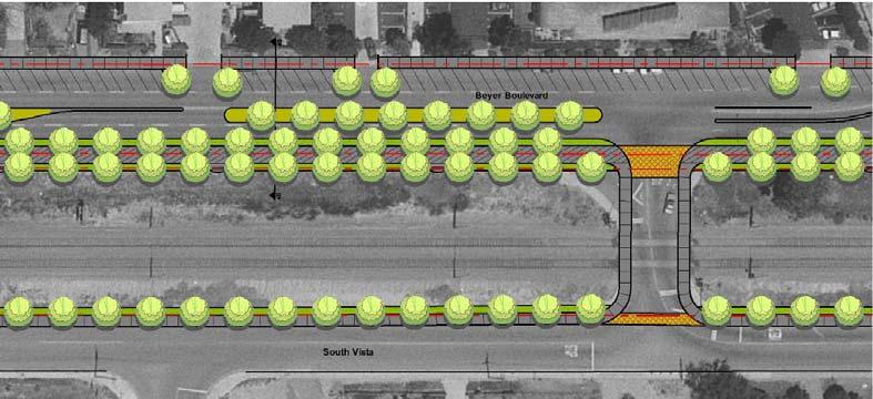
30 The Green Spine A major theme proposed in the study is the potential for a major green link adjacent to the railroad ROW and Beyer Boulevard. This link would extend from SR-905 to the Border. Major improvement 4 discusses this concept in more detail. 30
31 Major Road Improvement recommendations Several meetings with the San Ysidro community took place over the last six months. During these meetings, results of the traffic analysis were shared, which led to discussions related to potential improvements. Many of the improvements suggested did not directly correlate with the traffic analysis conducted in the study area. However, these improvements would help to improve the mobility at some of the affected areas within the community. The following paragraphs summarize the key findings and conclusions of improvements. It should be noted that alternatives are provided for several improvements. Locations of the recommended improvements summarized below are illustrated below. Figure 5-1 Location of Recommended Improvements 31

32 Improvement 1 Improvements along Dairy Mart Road This project involves widening Dairy Mart Road by 30 to 34 feet between W. San Ysidro Boulevard and Camino de la Plaza to accommodate one additional travel lane in each direction, bike lanes, and expanded sidewalks. The project would also expand the existing Dairy Mart Road intersection with the I-5 southbound on- and off-ramps and widen the Dairy Mart Road bridge over I-5. This improvement has been developed to improve connectivity between the northern and southern portions of the San Ysidro community for vehicular and non-motorized modes of travel. Assessment of Improvement Improvement 1 will provide additional capacity for vehicular and pedestrian traffic and provide new Class II bike lanes. The additional through and turning lanes at the I-5 southbound/dairy Mart Road intersection would be expected to reduce delay for all traffic passing through this intersection. The project is a recommended improvement in the Transportation and Circulation Element of the San Ysidro Community Plan. Conceptual Layout of Improvement 1 32
33 Improvement 2A Removal of Southbound Off-Ramp at Via de San Ysidro This improvement project involves replacing the existing I-5 southbound off-ramp to Via de San Ysidro with a new off-ramp that would terminate at Calle Primera, to the west of Via de San Ysidro. The new off-ramp would be controlled by a traffic signal. This improvement has been identified to improve the operation of the five-legged I-5 southbound off-ramp/via de San Ysidro/Calle Primera intersection. Assessment of Improvement Improvement 2A will benefit local mobility in several ways. Removing the southbound off-ramp from the Via De San Ysidro/Calle Primera intersection is expected to reduce delay for all motorists passing through the intersection. The improvement would also remove the very short merge for traffic proceeding I-5 southbound to Calle Primera eastbound and increase storage available for southbound traffic on Via de San Ysidro, north of Calle Primera. While the new T intersection at I-5 southbound/calle Primera will likely improve access for I-5 southbound traffic, it would be expected to slightly increase travel time for through traffic on Calle Primera, due to the installation of the new signal. The improvement is not identified as a recommended improvement in the Transportation and Circulation Element of the San Ysidro Community Plan. Conceptual Layout of Improvement 2A 33

34 Improvement 2B Removal of Southbound Off-Ramp at Via de San Ysidro and Construction of New Southbound On-Ramp This improvement project involves removing the existing I-5 southbound off-ramp to Via de San Ysidro, and constructing a new hook type southbound on- and off-ramp at Calle Primera. The new on- and off-ramp would be controlled by a traffic signal. This improvement has been developed both to improve the operation of the I-5 southbound off-ramp/via de San Ysidro/Calle Primera intersection and to complete the I-5/Via de San Ysidro interchange. Assessment of Improvement As with improvement 2A, the removal of the southbound off-ramp from the Via De San Ysidro/Calle Primera intersection would likely reduce delay for all vehicles traversing the intersection. The improvement would improve queue storage and merging for southbound traffic. Construction of the new signalized T intersection at I-5 southbound/calle Primera will facilitate access to and from I-5 southbound but also slow down through traffic on Calle Primera. In addition, the project would provide a southbound on-ramp, which is not currently provided at the interchange. One key issue with respect to this improvement is the feasibility of the new southbound on-ramp. In addition to a steep upward slope from Calle Primera to I-5 southbound, the on-ramp would like result in a short merging distance for traffic entering the freeway main lanes. It may be necessary to widen the I-5 bridge over Via de San Ysidro to provide additional merging distance for these vehicles. As with improvement 2A, improvement 2B is not identified as a recommended improvement in the Transportation and Circulation Element of the San Ysidro Community Plan. Conceptual Layout of Improvement 2B 34

35 Improvement 3A Connection from Calle Primera to Camino de la Plaza (via Bibler Drive) This improvement project would extend Calle Primera to the east and construct Bibler Drive to the north and east from its existing intersection with Anelia Drive to form a T intersection with the extension of Calle Primera. The new roadway segment would be a two-lane collector, and an new traffic signal would be provided at the Calle Primera/Bibler Drive intersection. This improvement has been developed to provide an additional east/west linkage in the community and to provide a more direct connection between Camino de la Plaza and the I-5/Via de San Ysidro interchange. Assessment of Improvement This improvement would provide a significant mobility benefit for those living in the residential community along the east side of Camino de la Plaza, west of Willow Road. Whereas access from I- 5 northbound currently requires some out-of-direction travel for the community, the new connection would provide a direction connection from I-5 to this area. One potential drawback for this improvement is that through traffic on Camino de la Plaza may divert to this connection, resulting in increased cut-through traffic in the community. If this improvement were to be implemented together with either improvement 2A or 2B, then two new closely-spaced traffic signals would be constructed on Calle Primera, west of Via de San Ysidro. The concept for this improvement, although along a slightly different alignment, is identified in the Transportation and Circulation Element of the San Ysidro Community Plan. Conceptual Layout of Improvement 3A 35

36 Improvement 3B Connection from Calle Primera to Camino de la Plaza (via new road north of Bibler Drive This improvement project would construct a new two-lane collector roadway between Camino de la Plaza and Via Tercero, to the north of the residential community. This improvement has the same premise as improvement 3A: to provide an additional east/west linkage in the community and to provide a more direct connection between Camino de la Plaza and the I-5/Via de San Ysidro interchange. Assessment of Improvement Similar to improvement 3A, this improvement would reduce out-of-direction travel for I-5 northbound traffic en route to the residential area on the east side of Camino de la Plaza. Although the improvement would involve some additional travel distance along Calle Primera and Via Tercero, it would avoid cut-through traffic traversing the residential area. The concept for this improvement, though on a different alignment, is identified in the Transportation and Circulation Element of the San Ysidro Community Plan. Conceptual Layout of Improvement 3B 36

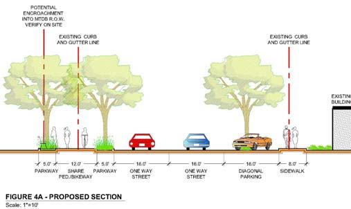
37 Improvement 4 Improvements to Beyer Bouelvard This improvement project would reconfigure Beyer Boulevard between Dairy Mart Road and Smythe Avenue. The existing lane configuration is two through lanes in each direction with parallel parking along both sides of the roadway and no median. The revised layout would provide one lane in each direction, separated by a two-way center turn lane. Diagonal parking would be provided along the north side of the roadway only. This improvement has been developed to improve access to and from adjacent land uses and to increase parking supply. presents a conceptual sketch of the improvement. Assessment of Improvement Although the existing design provides one additional through lane in each direction, the potential capacity of these lanes is reduced by various factors (including friction caused by narrow lane widths and parking maneuvers). Also, vehicles wishing to make left turns into driveways block the inner lanes while awaiting gaps in opposing traffic and people who park on the south side must cross the street to access adjacent properties. Improvement 4 will improve mobility by separating left turn movements from through traffic and by providing wider through lanes. Access to and from land uses on the north side of the roadway will benefit from the increased parking supply, and pedestrian crossings from the south to the north will be eliminated. This improvement is not consistent with the classification shown in the Transportation and Circulation Element of the San Ysidro Community Plan. Conceptual Layout of Improvement 4 2 possible alternatives are shown on the next page. 37


38 38

39 Improvement 5 Improvements at Beyer Boulevard Trolley Station This improvement project would construct a new signalized intersection at the Beyer Boulevard trolley station driveway. A new driveway would be constructed in the parking lot opposite the trolley station, and Beyer Boulevard would be restriped to provide left turn pockets for both eastbound and westbound traffic. The existing crosswalk would be shifted from its current location to the new intersection. This improvement has been developed to facilitate access to and from the trolley station. Assessment of Improvement Improvement 5 would benefit both vehicular and pedestrian access to and from the station. The new signal would regulate traffic and pedestrian movements, stopping through traffic to allow left turns into and out of the site and pedestrians to cross the four-lane segment of Beyer Boulevard. This improvement is not identified as a recommended improvement in the Transportation and Circulation Element of the San Ysidro Community Plan. Conceptual Layout of Improvement 5 39

40 Improvement 6A Improvements on East Park Avenue and West Park Avenue (with Diagonal Parking) This improvement project would restripe East Park Avenue and West Park Avenue from Hall Avenue to San Ysidro Boulevard. The current roadway design provides one 17-foot through lane and one 12-foot parallel parking lane. The proposed design would narrow the through lane 12 feet and provide a 16-foot diagonal parking lane on both roadways adjacent to the San Ysidro Community Park recreational facilities. This improvement has been suggested in order to improve access to the park and to increase parking supply. Assessment of Improvement Improvement 6A would eliminate pedestrian crossings from the existing parking lane to the park by shifting through traffic to the outer edge of the pavement and locating the diagonal parking on the same side of the street as the park. In addition, improvement 6A would widen existing sidewalks adjacent to the park, enhancing pedestrian mobility. This improvement is not identified as a recommended improvement in the Transportation and Circulation Element of the San Ysidro Community Plan. Conceptual Layout of Improvement 6A 40

41 Improvement 6B Improvements on East Park Avenue and West Park Avenue (with Parallel Parking) This improvement project would restripe East Park Avenue and West Park Avenue from Hall Avenue to San Ysidro Boulevard. The current roadway design provides one 17-foot through lane and one 12-foot parallel parking lane. The proposed design would narrow both the through lanes and the parking lanes in order to provide wider sidewalks on both sides of the roadway. This improvement has been developed to enhance existing pedestrian facilities in the area. Assessment of Improvement Although improvement 6B does not shift the parking lane from the outer edge of the roadway to the park, the reduced pavement width may act to slow traffic in this area, and improve the safety of pedestrian crossings from the parking lanes to the park. This improvement is not identified as a recommended improvement in the Transportation and Circulation Element of the San Ysidro Community Plan. Conceptual Layout of Improvement 6B 41

42 42

43 Improvement 7 Improvements along Hall Avenue This improvement project would provide a curb bulb-out along the north side of Hall Avenue, between West Park Avenue and East Park Avenue, and an expanded sidewalk on the opposite side of the street. The bulb-out and expanded sidewalk would narrow this segment of Hall Avenue from 60 feet to 40 feet of pavement. Diagonal parking spaces would be placed within the bulb-out, and crosswalks would be provided parallel to East Park Avenue and West Park Avenue. This improvement has been suggested in order to facilitate pedestrian access in the vicinity of the San Ysidro Community Park recreational facilities. Assessment of Improvement Improvement 7 would benefit northbound and southbound pedestrian mobility by reducing Hall Avenue s width. The diagonal spaces within the bulb-out will also enhance parking supply in the vicinity of the park. The bulb-out is not expected to adversely impact east/west traffic flow, because the roadway alignment would match up with the segments to the east and to the west. This improvement is not identified as a recommended improvement in the Transportation and Circulation Element of the San Ysidro Community Plan. 7 Conceptual Layout of Improvement 43
 of one-way streets, with E.")
44 Improvement 8 One-Way Couplet: E. San Ysidro Boulevard (Northbound) and Border Village Road (Southbound) This improvement would convert E. San Ysidro Boulevard and Border Village Road from separate two-way streets into a pair (or couplet ) of one-way streets, with E. San Ysidro Boulevard accommodating northbound traffic, and Border Village Road serving southbound movements. E. San Ysidro Boulevard would accommodate normal two-way traffic to the north and south of its two intersections with Border Village Road. Southbound traffic approaching the northern intersection would be channeled onto the Border Village Road, which would be restriped to provide two southbound through lanes and parking lanes and sidewalks on both sides of the street. Similarly, northbound motorists approaching the southern intersection would continue on E. San Ysidro Boulevard, which would provide a similar lane configuration. Motorists wishing to reverse directions without completing a loop would be able to turn onto Virginia Avenue and then make a left turn onto either E. San Ysidro Boulevard or Border Village Road. This improvement has been developed in order to alleviate traffic congestion in this area Assessment of Improvement Improvement 8 would improve local mobility by eliminating conflicting left turn movements for northbound and southbound motorists on the couplet. Movements at both E. San Ysidro Boulevard/Border Village Road intersections would also be simplified. This would likely reduce vehicle delay at both signals. The couplet system would necessitate some out-of-direction travel for southbound through traffic on E. San Ysidro Boulevard and for other motorists, depending on their directionality and the location of their destination. Couplet operations would also be expected to increase traffic on Virginia Avenue. This improvement is identified in the recommended street classifications map in the Transportation and Circulation Element of the San Ysidro Community Plan. Conceptual Layout of Improvement 8 44

45 Improvement 9 Remove Connection From E. San Ysidro Boulevard to I-5 Northbound This improvement would remove the existing connection from E. San Ysidro Boulevard to I-5 northbound immediately to the north of the US/Mexico International Border. This improvement assumes that other planned improvements associated with the border crossing, included a new northbound on-ramp from Camino de la Plaza to I-5 will be constructed and will accommodate diverted traffic. Improvement 9 would also remove the existing median on E. San Ysidro Boulevard in order to allow left turns in and out of an existing parking lot located south of Camino de la Plaza. The intent of this improvement is to reduce vehicle/pedestrian conflicts on this segment. Assessment of Improvement Improvement 9 would improve pedestrian mobility by eliminating conflicts between vehicles and pedestrians on the roadway segment between E. San Ysidro Boulevard and the I-5 northbound onramp. Data collection suggests this location has among the highest pedestrian volumes in San Diego County (excluding special events). Implementation of this improvement would result in some out-ofdirection travel for vehicles leaving the parking lot; however, this distance will be relatively minor following construction of the new I-5 on-ramp at Camino de la Plaza. This improvement is not identified as a recommended improvement in the Transportation and Circulation Element of the San Ysidro Community Plan. Conceptual Layout of Improvement 9 45

46 46
47 Attachment 2 SAN YSIDRO TRANSPORTATION COLLABORATIVE SAN YSIDRO MOBILITY STUDY- Summary of Responses by Members of the San Ysidro Transportation Collaborative I. Major Road Improvement Recommendations: To date responses, both formal and informal, have been received from San Ysidro Community Planning Group (SYCPG), San Ysidro Chamber of Commerce (SYCC), Hearts & Hands (H&H), San Ysidro Women s Club (SYWC), San Ysidro Business Association (SYBA), MTS, and SANDAG (see attachments). Of special note is the approach taken by SYCPG: to consider the several proposed major road improvements as working concepts, the details, including precise configurations, to be resolved in the succeeding Phase II (preliminary design, engineering, and financing plan). #1 Widen Dairy Mart Road and improve I-5 Southbound off-ramp at Dairy Mart Road This recommendation was supported by all five San Ysidro Community stakeholders who include SYCPG, SYCC, H&H, SYWC, and SYBA. SANDAG provided the following comment: The potential environmental challenges should be addressed in the assessment of this proposed improvement. #2 (a) Relocate I-5 Southbound off-ramp at Via de San Ysidro This recommendation approved by all five aforementioned San Ysidro community stakeholders, with several additional pertinent comments: Loss of private land should be minimized (SYCPG) The potential pedestrian and business impacts should be addressed in the assessment of this proposed improvement (SANDAG, also SYWC) #3 Connect Calle Primera to Camino de la Plaza: This recommendation was supported by the five entities, the only variation the precise alternative routing (to be determined in Phase II). SYBA feels that 3B is preferred, as is the shortest route with least wetlands and housing subdivision (Coral Gate) impacts The potential environmental challenges should be addressed in the assessment of this proposed improvement (both options). The proposed extension appears to traverse a potentially sensitive habitat area, which would trigger the need for environmental studies and permitting. (SANDAG) #4 Improve Beyer Blvd. between Dairy Mart Road and Smythe Avenue, including a new pedestrian bridge over the trolley tracks at Del Sur: This recommendation was supported by SYCC, SYCPG, SYWC, and H&H; SYBA did not address. MTS expressed its support of the concept of adding a bridge at this location 47
48 Should illustrate and clarify how north and south pedestrian crossings would be eliminated (SANDAG) An estimate of the pedestrian demand would help justify the proposed pedestrian bridge over the railway right-of-way at Del Sur (SANDAG) It is important that work be done with MTS prior to the designing of the bridge to ensure that all concerns related to possible impacts to the existing trolley right-of-way are addressed. (It is likely) that any project that is built within the right-of-way of the rail corridor will likely require PUC approval before construction. (MTS) With diagonal parking (i.e., vehicles backing into traffic), how will safety issues be addressed? (SYBA) #5 Install new traffic signal at Beyer Blvd. in front of the Beyer Trolley Station: This recommendation was supported by SYCC, SYCPG, SYWC, and H& H; SYBA did not address. SANDAG commented: The proposed signalized intersection and other proposed improvements would greatly improve pedestrian safety and access to this trolley station. #6 Improve West Park Avenue and East Park Avenue This recommendation was supported by SYCPG, SYCC, SYWC, and H&H; SYBA did not address directly, but did have the following comment: Not being able to park immediately in front of their residences may become an issue. West Park with diagonal parking would be too narrow since this is used more than E. Park; may want to consider diagonal parking on E. Park only; also may increase vandalism (H&H, SYWC) #7 Improve Hall Avenue between West and East Park This recommendation was supported by SYCPG, SYCC, SYWC and H&H; SYBA did not address. #8 Convert East San Ysidro Blvd. and Border Village Road to one-way couplets: This recommendation was not supported by any of the San Ysidro stakeholders, at this time. Taking note of this, the consultants commented: Notwithstanding this negative vote, a number of streetscape improvements could go forward (e.g. widening of sidewalks). SANDAG commented: The proposed one-way couplets may present a set of complex traffic circulation, pedestrian, and business impacts, some positive and some negative. Additional analysis should include measurable benefits, assessment of overall circulation impacts, pedestrian, business, and other community impacts. #9 Reconfigure I-5 Northbound on and off-ramps at the San Ysidro Border Crossing: This recommendation was supported by SYCPG, SYCC, SYWC, and H&H with the following variation: Retain current on/off ramp while at same time providing for an additional on/off ramp at the top of Camino de la Plaza Bridge. Note SYBA requested more study; this organization having met prior to aforementioned variation was put forward as an option. 48
49 Clarity needed in text: what and precisely where proposed, and how will impact traffic patterns (and reduce pedestrian and vehicle conflict at Rail Court/I-5 northbound entrance) One rationale for proposed variation: estimated that will reduce by at least 75% number of vehicles accessing I-5 at current northbound entrance It will be important to determine from GSA that auxiliary exit at top of Camino de la Plaza Bridge will permit access from most, if not all, vehicle entry lanes at the border II. Minor Recommendations and Other Comments: 1. Green Spine Mentioned in the text, this concept should be more fully developed, particularly to the extent that envisions continuation southbound from Beyer Blvd. junction with East Beyer Blvd to East San Ysidro Blvd./Camino de la Plaza MTS commented: Before any landscaping is considered adjacent to or within the trolley right-of-way, it is extremely important that MTS is involved in the process.in designing the green link, the following items should be taken into consideration and discuss in more detail with MTS to reduce and eliminate any fatal safety or operation concerns that are inherent to landscaping projects along rail corridors: All trees and landscaping should be appropriately spaced and positioned; Tree types (perennial vs. annuals) consideration; Size or type of tree canopy consideration; Irrigation: How is it installed and where does the run off go? Who is responsible for the maintenance of landscaping (who pays and how often the landscaping is serviced?). Does Green Spine form one of two sets of ring roads? To westside Camino de la Plaza northbound to I-5 via Dairy Mart Road? On the east side: Camino de la Plaza northbound via E. Beyer Blvd. and Beyer Blvd.? 2. Bicycle Facilities: The cross-sections do not identify bicycle facilities. This area currently has an extreme lack of bikeway facilities. However, people do use bicycles for access to the border, and this may be the only form of personal transportation for some in our lower-income communities.this mobility plan should address this form of transportation.room for bike lanes should be sought where there are no bike lanes identified. Some of the street cross sections show 12-foot travel lanes. Since the City of San Diego s design standards allow widths of 11 feet, sometimes there is room for bike lanes by shaving space from other travel lanes or ROW. (SANDAG) 3. Public Transit: MTS commented: Public transit plays a vital role in providing mobility options.as such, MTS would like to see more emphasis on the importance of transit, its role and how it can be enhanced to more effectively provide service to those working, living or shopping in San Ysidro.Two of the major obstacles are signalized intersections and traffic delays. Being that San Ysidro is located adjacent to one of the busiest border crossings in the world, the impacts on transit related to signalized intersections and traffic 49
50 delays are compounded and greater than in the typical operating environment of transit. One way is through the installation of signal priority measures, signal preemption and/or bus bypass lanes at intersections. These technologies held keep transit moving in areas where traffic delays would typically penalize transit and make it less effective and attractive The two main corridors listed below should be looked at more closely to determine where these improvements can be made and included into the SYMS plan: San Ysidro Blvd between Camino de la Plaza and Smythe Avenue, and Camino de la Plaza between Willow Road and San Ysidro Blvd. 4. Other mobility improvements that should be considered: Convert Smythe and Alverson as one-way streets to/from Sunset Lane and W. San Ysidro Blvd. associated with Sunset school (San Ysidro School District) Improve directional signage for motorists to freeways as in other communities Provide easier to read detail location and type of other streetscape improvements, associated with the nine major recommendations, but also in other areas of the community Consider other mobility improvements, such as: a pedestrian scramble at Rail Court and East San Ysidro Blvd.; a second or dual left turning lane exiting W. Calle Primera on to Via de San Ysidro; and improved traffic signal synchronization through prime choke point corridor Via de San Ysidro on both sides of I-5 (to/from San Ysidro Blvd. and Calle Primera) III. Edits- Reference is made to: Introduction and Context and Existing Conditions sections to SANDAG s letter of January 22, 2008 (see attachment). Series of proposed edits Steve Otto s dated December 10, 2007 Respectfully submitted, Steven E. Otto Coordinator San Ysidro Transportation Collaborative January 29, 2008 (revised) ATTACHMENTS: 1. SYBA Special Board of Directors Meeting, January 10, MTS Letter of January 16, SYCPG Letter of January 17, SANDAG Letter of January 22, Combined comments Hearts & Hands and Women s Club of January 28, S. Otto series of proposed edits (12/10/07) 50
51 San Diego Association of Governments COMMITTEE ON BINATIONAL REGIONAL OPPORTUNITIES April 1, 2008 AGENDA ITEM NO.:9 Action Requested: INFORMATION PRESENTATION ON DISTINCTIVE PROJECTS COMPANY (DPC) - File Number BROWN FIELD S PROPOSAL TO REDEVELOP BROWN FIELD AIRPORT Introduction This report is being presented to COBRO to follow up on initiatives included in the Otay Mesa- Mesa de Otay Binational Corridor Strategic Plan. Background Brown Field Airport is owned and operated by the City of San Diego. The Airport encompasses approximately 880 acres and is located in the north eastern part of the Otay Mesa Community Plan area. In 2005, the airport recorded more than 117,000 operations and in 2006, operations increased to over 135,000. It possesses the longest civilian runway in San Diego County, outside of Lindbergh Field, allowing it to accommodate a wide variety of aircraft. There are 65 acres identified for development, that if developed would represent a significant increase in leasing revenue. Discussion On December 26, 2006, the City of San Diego issued a Request for Qualifications (RFQ) to develop and operate a Fixed Base Operator (FBO) or other aviation related business on Brown Field. Applicants needed to submit proposals that demonstrate their ability to support Brown Field s mission to develop, operate, maintain, and promote the airport for the public benefit, airport users, and the communities it serves. There were a total of six applicants to the RFQ. Two were selected, based on a point system, to move forward to the next phase of responding to the Request for Proposal (RFP). On January 23, 2008, the City of San Diego s Land Use & Housing Committee unanimously approved for City of San Diego staff to exclusively negotiate a development lease for various locations in Brown Field with Distinctive Projects Company, Inc. (DPC-Brown Field). DPC-Brown Field will provide an informational overview on their plans to redevelop Brown Field. Attachment: 1. Otay Mesa-Mesa de Otay Binational Corridor Strategic Plan Study Area Key Staff Contact: Ron Saenz, (619) , rsa@sandag.org 51

52 Attachment 1 52
I 5 South Multimodal Corridor Study. Appendix B. Issue Statement
 I 5 South Multimodal Corridor Study Appendix B I-5 SOUTH MULTIMODAL CORRIDOR STUDY ISSUE STATEMENT JUNE 5, 2009 PROJECT DESCRIPTION The goal of the Interstate 5 (I-5) South Multimodal Corridor Study is
APPENDIX D - APPENDIX E - APPENDIX F - APPENDIX G - APPENDIX H
 Appendices APPENDIX A - CROSSING VOLUMES AND WAIT TIMES APPENDIX B - DOCUMENT REVIEW APPENDIX C - STUDY AREA AND MAJOR DESTINATIONS APPENDIX D - NETWORK CONNECTIVITY ASSESSMENT APPENDIX E - NETWORK AMENITIES
Cross-Border Transportation
 Cross-Border Transportation Monterrey, Mexico May 8th & 9th, 2006 Pedro Orso-Delgado, Director Caltrans District 11 Outline California/Baja California Border Region Border Reality Trade Statistics Institutional
COMMITTEE ON BINATIONAL REGIONAL OPPORTUNITIES
 San Diego Association of Governments COMMITTEE ON BINATIONAL REGIONAL OPPORTUNITIES September 4, 2018 AGENDA ITEM NO.: 7 Action Requested: INFORMATION 2017 SAN DIEGO BAJA CALIFORNIA BORDER CROSSING File
MEETING NOTICE AND AGENDA
 MEETING NOTICE AND AGENDA COMMITTEE ON BINATIONAL REGIONAL OPPORTUNITIES (COBRO) The Committee on Binational Regional Opportunities (COBRO) may take action on any item appearing on this agenda. Tuesday,
4-71. Tecate / Tecate. Ports of Entry Tecate Pedestrian/ Transit Facilities
 Figure 4.17: Roadway and Interchange and Non-Motorized Modes of Crossborder Travel Projects - Tecate-Tecate POE California-Baja California 2014 Border Master Plan Update Non-Motorized Facilties Interchange
SMART BORDER COALITION
 SMART BORDER COALITION SAN DIEGO-TIJUANA The World s Largest Bi-National Metropolitan Area More then 5 million citizens! Mission Statement To help assure border efficiency between the Californias. What
San Diego Regional Briefing I-5 South Realignment Communications Plan
 San Diego Regional Briefing I-5 South Realignment Communications Plan GSA Public Buildings Service 50 United Nations Plaza, San Francisco, CA www.gsa.gov 2 3 Project Overview PHASE 1E VATC WEST PED GSA
Zones of Hope. Challenges and Opportunities in Improving U.S.-Mexico Border Economic Micro-Zones. Project Preview
 Zones of Hope Challenges and Opportunities in Improving U.S.-Mexico Border Economic Micro-Zones Project Preview July 2016 1 Research Team Erik Lee, Rick Van Schoik and Siria Alvarez, North American Research
San Diego Association of Governments BORDERS COMMITTEE
 San Diego Association of Governments BORDERS COMMITTEE July 22, 2005 AGENDA ITEM NO.: 1 Action Requested: APPROVE File Number 3003200 JOINT MEETING OF THE BORDERS COMMITTEE AND THE COMMITTEE ON BINATIONAL
MEETING NOTICE AND AGENDA
 MEETING NOTICE AND AGENDA COMMITTEE ON BINATIONAL REGIONAL OPPORTUNITIES The Committee on Binational Regional Opportunities (COBRO) may take action on any item appearing on this agenda. Tuesday, June 7,
Economic Impact Study: Otay Mesa East Port of Entry. e RB. conomic research bureau
 Economic Impact Study: Otay Mesa East Port of Entry e RB Executive Summary This study estimates the economic impact from the construction of an additional Port of Entry (POE) on the U.S.- Mexico border
FINAL REPORT SAN DIEGO REGION-BAJA CALIFORNIA CROSS-BORDER TRANSPORTATION STUDY
 FINAL REPORT SAN DIEGO REGION-BAJA CALIFORNIA CROSS-BORDER TRANSPORTATION STUDY Prepared for SAN DIEGO ASSOCIATION OF GOVERNMENTS Prepared by PARSONS TRANSPORTATION GROUP In Association with CIC RESEARCH
Second Binational Summit
 Second Binational Summit of the United States-Mexico Border Mayors Association Tijuana, B.C., February 09, 2012 Joint Declaration XX Ayuntamiento de Tijuana SECOND BINATIONAL SUMMIT OF THE UNITED STATES-MEXICO
POSSIBLE 2,000+ UNIT RESIDENTIAL / MULTI-USE ENTITLEMENT OPPORTUNITY 128 ACRES
 An Opportunity to Design a New Village Specific Plan Allows Various Uses & Densities Ocean and Downtown Views Offers Due Friday August 21, 2015 W UNITED STATES/MEXICO BORDER San Ysidro Middle School Las
Freeway Deficiency Plan Final. Central Interstate 5 Corridor Study
 Freeway Deficiency Plan Final Central Interstate 5 Corridor Study December 2003 Prepared for: San Diego Association of Governments 401 B Street, Suite 800 San Diego, CA 92101 Prepared by: 1615 Murray Canyon
COMMITTEE ON BINATIONAL REGIONAL OPPORTUNITIES
 San Diego Association of Governments COMMITTEE ON BINATIONAL REGIONAL OPPORTUNITIES September 5, 2017 AGENDA ITEM NO.:6 Action Requested: INFORMATION 2016 SAN DIEGO BAJA CALIFORNIA BORDER CROSSING File
YEAR END PROGRESS REPORT-2013
 SMART BORDER COALITION San Diego-Tijuana YEAR END PROGRESS REPORT-2013 ENVISION THE BORDER AS IT SHOULD BE OPPORTUNITY COMES FROM A SEAMLESS INTERNATIONAL REGION WHERE ALL CITIZENS WORK TOGETHER FOR MUTUAL
Freeway Deficiency Plan Final. Central Interstate 5 Corridor Study
 Freeway Deficiency Plan Final Central Interstate 5 Corridor Study December 2003 Prepared for: San Diego Association of Governments 401 B Street, Suite 800 San Diego, CA 92101 Prepared by: 1615 Murray Canyon
TECHNICAL ADVISORY COMMITTEE AGENDA N. Imperial Ave., Suite 1 El Centro, CA 92243
 TECHNICAL ADVISORY COMMITTEE AGENDA DATE: Thursday, February 26, 2015 TIME: LOCATION: 10:00 a.m. 12:00 p.m. Offices 1405 N. Imperial Ave., Suite 1 El Centro, CA 92243 Chairperson: Bill Brunet, County of
TRANSPORTATION COMMITTEE
 San Diego Association of Governments TRANSPORTATION COMMITTEE July 15, 2011 AGENDA ITEM NO.: 1 Action Requested: APPROVE TRANSPORTATION COMMITTEE DISCUSSION AND ACTIONS MEETING OF JUNE 17, 2011 The meeting
Summary of At-Border Data Collection Results
 Summary of At-Border Data Collection Results Economic and Air Quality/Climate Impacts of Delays at the Border San Diego, CA December 8, 2017 1 Contents Introduction... 4 Overview of the Study Area... 4
BORDERS COMMITTEE AGENDA
 Members Patricia McCoy, Chair Mayor Pro Tem, Imperial Beach (Representing South County) Greg Cox, Vice Chair Chairman, County of San Diego Crystal Crawford Deputy Mayor, Del Mar (Representing North County
3.12 TRAFFIC AND CIRCULATION
 3.12 TRAFFIC AND CIRCULATION 3.12 Transportation and Circulation This section of the Draft EIR analyzes the existing transportation system in the area and addresses the potential transportation and circulation
AGENDA SAN DIEGUITO RIVER VALLEY REGIONAL OPEN SPACE PARK CITIZENS ADVISORY COMMITTEE. 10:30 a.m. to 12:15 p.m. Friday, December 2, 2011
 AGENDA SAN DIEGUITO RIVER VALLEY REGIONAL OPEN SPACE PARK CITIZENS ADVISORY COMMITTEE 10:30 a.m. to 12:15 p.m. Friday, December 2, 2011 Hope United Methodist Church 16550 Bernardo Heights Parkway (Corner
San Diego Association of Governments BORDERS COMMITTEE. BORDERS COMMITTEE DISCUSSION AND ACTIONS Meeting of February 24, 2006
 April 28, 2006 San Diego Association of Governments BORDERS COMMITTEE AGENDA ITEM NO.: 1a Action Requested: APPROVE BORDERS COMMITTEE DISCUSSION AND ACTIONS Meeting of February 24, 2006 The regularly scheduled
Van Ness Business Advisory Committee Thursday, May 19, :00-4:30pm One South Van Ness, 3 rd Floor, Civic Center Conference Room (3074)
") Van Ness Business Advisory Committee Thursday, May 19, 2016 3:00-4:30pm One South Van Ness, 3 rd Floor, Civic Center Conference Room (3074) MINUTES 1. Meeting was called to order at 3:05 p.m. 2. Public
Van Ness Business Advisory Committee Thursday, May 19, 2016 3:00-4:30pm One South Van Ness, 3 rd Floor, Civic Center Conference Room (3074) MINUTES 1. Meeting was called to order at 3:05 p.m. 2. Public
Van Ness BRT Community Advisory Committee Thursday, May 19, :00-7:30 p.m. One South Van Ness, 7 th floor, Union Square Conference Room
 Van Ness BRT Community Advisory Committee Thursday, May 19, 2016 6:00-7:30 p.m. One South Van Ness, 7 th floor, Union Square Conference Room MINUTES 1. Meeting was called to order at 6:02 p.m. 2. Public
Columbia River Crossing Investment Grade Traffic and Revenue Study
 Columbia River Crossing Investment Grade Traffic and Revenue Study Columbia River Crossing First Phase Project December 27, 2013 Image courtesy of CRC Project Office (Page Intentionally Left Blank) Table
AGENDA CITIZENS ADVISORY COMMITTEE MEETING SAN MATEO COUNTY TRANSPORTATION AUTHORITY
 BOARD OF DIRECTORS 2018 DON HORSLEY, CHAIR CAMERON JOHNSON, VICE CHAIR EMILY BEACH CAROLE GROOM MAUREEN FRESCHET KARYL MATSUMOTO RICO E. MEDINA AGENDA JIM HARTNETT EXECUTIVE DIRECTOR CITIZENS ADVISORY
AGENDA. Wednesday, January 9, 2013 TAMC Conference Room 55-B Plaza Circle, Salinas. ***9:00 a.m.***
 AGENDA TRANSPORTATION AGENCY FOR MONTEREY COUNTY SERVICE AUTHORITY FOR FREEWAYS EMERGENCIES AND MONTEREY COUNTY REGIONAL DEVELOPMENT IMPACT FEE JOINT POWERS AGENCY EXECUTIVE COMMITTEE Members are: Simon
I-5 Empire Project. 3 rd Annual. Community Open House. June 9, 2016
 I-5 Empire Project 3 rd Annual Community Open House June 9, 2016 Project Overview What: A series of improvements to I-5, local streets and the railroad tracks in Burbank between Magnolia Blvd. and Buena
OUTLETS AT THE BORDER
 PRIME RESTAURANT SPACE AT THE US/MEXICO BORDER OUTLETS AT THE BORDER 4463 Camino De La Plaza, San Ysidro, California 92173 FOR LEASE RESTAURANT SPACES FRONTING AND ADJACENT TO NEW INTERNATIONAL PEDESTRIAN
Orange County Transportation Authority
 Orange County Transportation Authority May 23, 2018 Keeping Orange County Moving Overview OCTA s FY 18-19 Budget SB 1 OC Streetcar Project I-405 Improvement Project I-5 Widening (SR-73 to El Toro) SR-55
ITS at the Border. Technologies, Strengths/Weaknesses & Why It s Important
 ITS at the Border Technologies, Strengths/Weaknesses & Why It s Important About Y2K Engineering Founded in 2017 by Yung Koprowski Headquartered in Gilbert, AZ Y2K is a transportation planning and civil
THREE UNIT, RETAIL/OFFICE OPPORTUNITY
 THREE UNIT, RETAIL/OFFICE OPPORTUNITY 161 W. SAN YSIDRO BLVD SAN YSIDRO, CA 92173 Anthony Acosta, BRE# 01900150 Advisor 619.658.1103 anthony.acosta@svn.com CalBRE #01900150 Jorge Jimenez, BRE# 01413353
Conducted for. Estimating Economic Impacts of Border Wait Times at the San Diego-Baja California Region. April 6, Research you can trust.
 Estimating Economic Impacts of Border Wait Times at the San Diego-Baja California Region Conducted for April 6, 2005 Research you can trust. The direction you seek. The attention you deserve. Introduction
Airport Connectivity Subcommittee
 Members Steve Vaus, Chair Mayor, City of Poway Mary Salas Mayor, City of Chula Vista (Representing SANDAG) Kevin Faulconer Mayor, City of San Diego Georgette Gomez Council President, City of San Diego
MARINE CORPS BASE CAMP PENDLETON
 MARINE CORPS BASE CAMP PENDLETON Base Overview Marine Corps Base Camp Pendleton (Camp Pendleton) is located in North San Diego County (Figure 1). It is the Marine Corps largest West Coast expeditionary
Contributions to NAFTA COMMENT PERIOD
 SMART BORDER COALITION SAN DIEGO-TIJUANA 2508 Historic Decatur Road, Suite 130 San Diego, CA 92106 Contributions to NAFTA COMMENT PERIOD The San Diego Tijuana Smart Border Coalition appreciates the opportunity
Marine Corps Base Camp Pendleton
 Marine Corps Base Camp Pendleton Marine Corps Base Camp Pendleton (Camp Pendleton) is located in North San Diego County, neighbored by the City of to the south, the community of Fallbrook to the east,
MEXICO U.S. BORDER INFRASTRUCTURE
 MEXICO U.S. BORDER INFRASTRUCTURE Sean Carlos Cázares Ahearne Deputy Director General for Border Affairs Mexico s Ministry of Foreign Affairs (SRE) Future of North American Infrastructure North American
CITY COUNCIL WORK SESSION
 CITY OF SPRINGBORO 320 W. CENTRAL AVENUE, SPRINGBORO, OH CITY COUNCIL WORK SESSION THURSDAY, MARCH 7, 2019 ITEM 1. ITEM 2. 6:00 PM CITY COUNCIL John Agenbroad, Mayor Dale Brunner, Deputy Mayor/Ward 2 Stephen
TRAFFIC SAFETY ADVISORY COMMITTEE AGENDA REGULAR MEETING MONDAY, NOVEMBER 19, :00 P.M.
 **LOCATION OF MEETING ** SARGE LITTLEHALE COMMUNITY ROOM 22 ORINDA WAY CITY OF ORINDA 22 ORINDA WAY ORINDA, CA 94563 (925) 253-4200 A. Call to Order B. Roll Call TRAFFIC SAFETY ADVISORY COMMITTEE AGENDA
AMERICA S FRONT DOOR TO OUTLET SHOPPING
 AMERICA S FRONT DOOR TO OUTLET SHOPPING THE OPPORTUNITY At 136,000 square feet and prominently located at the San Diego/Tijuana border the world s busiest border crossing where 70 million cars and pedestrians
MEETING NOTICE AND AGENDA
 MEETING NOTICE AND AGENDA COMMITTEE ON BINATIONAL REGIONAL OPPORTUNITIES The Committee on Binational Regional Opportunities (COBRO) may take action on any item appearing on this agenda. Tuesday, November
Van Ness BRT Community Advisory Committee Thursday, August 25, :00-7:30 p.m. One South Van Ness, 7 th floor, Union Square Conference Room
 Van Ness BRT Community Advisory Committee Thursday, August 25, 2016 6:00-7:30 p.m. One South Van Ness, 7 th floor, Union Square Conference Room MEETING MINUTES 1. Meeting was called to order at 6:05 p.m.
CITY OF SAN MARINO TRAFFIC ADVISORY COMMISSION AGENDA
 CITY OF SAN MARINO TRAFFIC ADVISORY COMMISSION AGENDA James M. Coupe, Chairman www.cityofsanmarino.org Hunter Chang, Vice Chairman (626) 300-0700 Phone Arti Gupta, Commission Member (626) 300-0709 Fax
Agenda (work session)
") ibisbee Committee 118 Arizona Street Bisbee, AZ 85603 Wednesday, November 19 th, 2014 at 6:00 p.m. Agenda (work session) THE ORDER OR DELETION OF ANY ITEM ON THIS AGENDA IS SUBJECT TO MODIFICATION AT THE
ibisbee Committee 118 Arizona Street Bisbee, AZ 85603 Wednesday, November 19 th, 2014 at 6:00 p.m. Agenda (work session) THE ORDER OR DELETION OF ANY ITEM ON THIS AGENDA IS SUBJECT TO MODIFICATION AT THE
Project Update: September 2018 Public Outreach Executive Summary
 Project Update: September 2018 Public Outreach Executive Summary Overview Sound Transit developed and analyzed initial route and station concepts for the Tacoma Dome Link Extension (TDLE) project. In September
Phoenix Transportation 2050 (T2050) Update
 Update") Phoenix Transportation 2050 (T2050) Update Transportation Coordinator (TC) Webinar October 26, 2016 ShareTheRide.com 602.262.RIDE (7433) To hear us, turn up speakers or headset volume. Your microphone
Phoenix Transportation 2050 (T2050) Update Transportation Coordinator (TC) Webinar October 26, 2016 ShareTheRide.com 602.262.RIDE (7433) To hear us, turn up speakers or headset volume. Your microphone
US-131/US-131BR Interchange Options Kalamazoo County
 US-131/US-131BR Interchange Options Kalamazoo County 1 PROBLEM 19 March 2015 The Kalamazoo County portion of US-131 was constructed in the early 1960s. The US-131 Business Route (BR) was constructed at
THE TIJUANA-SAN DIEGO CROSS BORDER MARKET
 2014 MEDIA KIT THE TIJUANA-SAN DIEGO CROSS BORDER MARKET IN 2013, AN AVERAGE OF 42 MILLION INDIVIDUALS CROSSED THE BORDER FROM TIJUANA INTO SAN DIEGO SHOPPING IS THE #1 MOTIVE FOR INDIVIDUALS CROSSING
CITY OF LOS ALAMITOS 3191 Katella Aven ue Los Alam itos, CA AGENDA TRAFFIC COMMISSION REGULAR MEETING Wednesday, June 14, :00 PM
 CITY OF LOS ALAMITOS 3191 Katella Aven ue Los Alam itos, CA 90720 AGENDA TRAFFIC COMMISSION REGULAR MEETING Wednesday, June 14, 2017-7:00 PM NOTICE TO THE PUBLIC This Agenda contains a brief general description
G E B C O GENERAL BATHYMETRIC CHART OF THE OCEANS
 G E B C O GENERAL BATHYMETRIC CHART OF THE OCEANS From: Mr. David M. Clark, GEBCO Permanent Secretary, National Geophysical Data Center, NOAA/NESDIS, Code EGC, 325 Broadway, Boulder, Colorado, 80302, USA
VISION ZERO COMMITTEE Special Meeting Notice
 1 AGENDA VISION ZERO COMMITTEE Special Meeting Notice Date: Location: Commissioners: Wednesday, June 14, 2017; 10:30-11:30 a.m. Legislative Chamber, Room 250, City Hall Yee (Chair), Safai (Vice Chair)
Van Ness BRT Community Advisory Committee Thursday, June 23, :00-7:30 p.m. One South Van Ness, 7 th floor, Union Square Conference Room
 Van Ness BRT Community Advisory Committee Thursday, June 23, 2016 6:00-7:30 p.m. One South Van Ness, 7 th floor, Union Square Conference Room MEETING MINUTES 1. Meeting was called to order at 6:05 p.m.
CITY COUNCIL AGENDA. REGULAR MEETING Wednesday, November 18, :00 Noon Council Chambers, City Hall, 1275 Main Street, El Centro, CA 92243
 CITY COUNCIL AGENDA REGULAR MEETING Wednesday, November 18, 2009 12:00 Noon Council Chambers, City Hall, 1275 Main Street, El Centro, CA 92243 Mayor & Council Members can be reached at (760) 336-8989 Mayor:
AGEND. 9 a.m. to 12. San Diego UPDATE PROPOSED 2050 RTP REVIEW OF. Jack Dale, Chair Councilmember, Santee. County)
") Members Jack Dale, Chair Councilmember, Santee (Representing East County) Mattt Hall, Vice Chair Mayor, Carlsbad County Coastal) Jim Desmond Mayor, San Marcos County Inland) Carrie Downey Councilmember,
Members Jack Dale, Chair Councilmember, Santee (Representing East County) Mattt Hall, Vice Chair Mayor, Carlsbad County Coastal) Jim Desmond Mayor, San Marcos County Inland) Carrie Downey Councilmember,
March 2016 University Link Bus Integration Service Changes. Title VI Service Equity Analysis Final Adopted Changes
 March 2016 University Link Bus Integration Service Changes Title VI Service Equity Analysis Final Adopted Changes February 2016 Introduction Federal Transit Administration (FTA) Circular 4702.1B, Chapter
Supplemental Guide Signing Manual
 Supplemental Guide Signing Manual 2012 Table of Contents 1.0 Foreword... 2 1.1 Policy... 2 2.0 Criteria For Supplemental Guide Signing... 2 2.1 Introduction... 2 2.2 Responsibility... 4 2.3 Specific Criteria...
SBCAG STAFF REPORT. MEETING DATE: January 18, 2018 AGENDA ITEM: 6
 SBCAG STAFF REPORT SUBJECT: Committee Appointments MEETING DATE: January 18, 2018 AGENDA ITEM: 6 STAFF CONTACT: Marjie Kirn RECOMMENDATION: A. Appoint one delegate and one alternate to the California Association
Open House Summary and Analysis. I-35 from Rundberg Lane to US 290E Austin District, Travis County
 Open House Summary and Analysis I-35 from Rundberg Lane to US 290E Austin District, Travis County OPEN HOUSE SUMMARY AND ANALYSIS Table of Contents Proposed Improvements... 1 Purpose and Need... 1 Notices
AGENDA. August 1, 2017 Tuesday
 BOARD OF DIRECTORS 2017 AGENDA SAN MATEO COUNTY TRANSPORTATION AUTHORITY CITIZENS ADVISORY COMMITTEE Bacciocco Auditorium, 2 nd Floor 1250 San Carlos Avenue, San Carlos, CA 94070 CAROLE GROOM, CHAIR DON
16 June 13, 2012 Public Hearing APPLICANT: ANTHONY & ALYIAH PETERKIN
 REQUEST: Conditional Use Permit (Truck & Trailer Rental) 16 June 13, 2012 Public Hearing APPLICANT: ANTHONY & ALYIAH PETERKIN PROPERTY OWNER: NEWTOWN BAKER SHOPPING CENTER LLC STAFF PLANNER: Faith Christie
SAN FRANCISCO MUNICIPAL TRANSPORTATION AGENCY BOARD OF DIRECTORS AND PARKING AUTHORITY COMMISSION NOTICE OF MEETING AND CALENDAR
 SAN FRANCISCO MUNICIPAL TRANSPORTATION AGENCY BOARD OF DIRECTORS AND PARKING AUTHORITY COMMISSION NOTICE OF MEETING AND CALENDAR Tuesday, May 1, 2018 Room 400, City Hall 1 Dr. Carlton B. Goodlett Place
REPORT. Border Communication, Trade and Infrastructure. Report for the Texas-Mexico Strategic Investment Commission
 REPORT Border Communication, Trade and Infrastructure Report for the Texas-Mexico Strategic Investment Commission Agustin De La Rosa, Director, International Relations Office The Texas Department of Transportation
MEETING OF THE SAN DIEGO METROPOLITAN TRANSIT SYSTEM EXECUTIVE COMMITTEE 1255 Imperial Avenue, Suite 1000 San Diego, CA
 A. ROLL CALL MEETING OF THE SAN DIEGO METROPOLITAN TRANSIT SYSTEM EXECUTIVE COMMITTEE 1255 Imperial Avenue, Suite 1000 San Diego, CA 92101 MINUTES Chair Gomez called the Executive Committee meeting to
BOARD OF DIRECTORS. Draft Minutes of the February 26, 2009, Special Meeting City Council Chambers 808 West Spokane Falls Blvd., Spokane, Washington
 1230 West Boone Avenue Spokane, Washington 99201-2686 (509) 325-6000 BOARD OF DIRECTORS Draft Minutes of the, Special Meeting City Council Chambers 808 West Spokane Falls Blvd., Spokane, Washington MEMBERS
REPORT TO COUNCIL STANDING COMMITTEE OF COUNCIL ON CITY FINANCE AND SERVICES JULY 23, 25, 26, 27 AND 29, 2013
 REPORT TO COUNCIL STANDING COMMITTEE OF COUNCIL ON CITY FINANCE AND SERVICES JULY 23, 25, 26, 27 AND 29, 2013 A Regular Meeting of the Standing Committee of Council on City Finance and Services was held
CAPITAL METROPOLITAN TRANSPORTATION AUTHORITY BOARD OF DIRECTORS MEETING
 CAPITAL METROPOLITAN TRANSPORTATION AUTHORITY BOARD OF DIRECTORS MEETING 2910 East Fifth Street Austin, TX 78702 ~ Minutes ~ Executive Assistant/Board Liaison Gina Estrada 512-389-7458 Monday, March 21,
*3. MINUTES OF CITY COUNCIL/COMMUNITY DEVELOPMENT AGENCY MEETINGS: Approval of the minutes of the Regular meeting of May 17, 2011.
 In compliance with the Americans with Disabilities Act (ADA), if you need special assistance to participate in a City meeting or other services offered by this City, please contact the City Clerk s office,
Understanding Transit s Impact on Public Safety
 Understanding Transit s Impact on Public Safety June 2009 401 B Street, Suite 800 San Diego, CA 92101-4231 Phone 619.699.1900 Fax 619.699.1905 Online www.sandag.org UNDERSTANDING TRANSIT S IMPACT ON PUBLIC
BOARD OF DIRECTORS AGENDA LOSSAN RAIL CORRIDOR AGENCY BOARD OF DIRECTORS MEETING. Wednesday, November 28, :30 p.m. to 2:30 p.m.
 LOSSAN RAIL CORRIDOR AGENCY BOARD OF DIRECTORS MEETING Wednesday, November 28, 2018 12:30 p.m. to 2:30 p.m. Los Angeles County Metropolitan Transportation Authority Board Room - Third Floor One Gateway
Revitalization along the Hiawatha Corridor. Central Corridor Funders Collaborative and Learning Network
 Measuring Progress - Building Capacity - Realizing Potential Revitalization along the Hiawatha Corridor January 29, 2009 Central Corridor Funders Collaborative and Learning Network Mike Christenson, Director
APPENDIX B. Environmental Justice Evaluation
 Appendix B. Environmental Justice Evaluation 1 APPENDIX B. Environmental Justice Evaluation Introduction The U.S. Department of Transportation has issued a final order on Environmental Justice. This final
Three Bridges. PDXScholar
 Portland State University PDXScholar TREC Friday Seminar Series Transportation Research and Education Center (TREC) 11-20-2015 Three Bridges Robert Liberty Portland State University Let us know how access
An excavation permit is required for any excavation work within the public right-ofway.
 Section 1: PERMITS REQUIRED TO WORK ON CITY STREETS The following is a list of different types of permits issued by the Department of Public Works (DPW), the San Francisco Municipal Transportation Agency
SPECIAL PRESENTATIONS - 6:00 p.m.
 CITY COUNCIL OF THE CITY OF MORENO VALLEY CALL TO ORDER SPECIAL PRESENTATIONS - 6:00 p.m. 1. Award of Excellence from the Municipal Information Systems Association of California (Mitch Cochran, City of
VALLEY METRO RAIL PROJECTS UPDATE
 VALLEY METRO RAIL PROJECTS UPDATE Transportation Coordinator Webinar October 21, 2015 ShareTheRide.com 602.262.RIDE (7433) To hear us, turn up speakers or headset volume. Your microphone is muted. Ask
CITY OF FOLSOM CITY COUNCIL SPECIAL MEETING
 Kerri Howell, Council Member Andy Morin, Council Member CITY OF FOLSOM CITY COUNCIL SPECIAL MEETING www.folsom.ca.us FOLSOM CITY COUNCIL CHAMBERS 50 NATOMA STREET, FOLSOM, CA TUESDAY, FEBRUARY 12, 2008
SAN MATEO COUNTY TRANSIT DISTRIC 1250 SAN CARLOS AVENUE, SAN CARLOS, CALIFORNIA. CITIZENS ADVISORY COMMITTEE (CAC) MINUTES OF MEETING May 30, 2018
 MINUTES OF MEETING May 30, 2018") SAN MATEO COUNTY TRANSIT DISTRIC 1250 SAN CARLOS AVENUE, SAN CARLOS, CALIFORNIA CITIZENS ADVISORY COMMITTEE (CAC) MINUTES OF MEETING (Revised 6-29-2018) COMMITTEE MEMBERS PRESENT: S. Appenrodt, J. Baker,
SAN MATEO COUNTY TRANSIT DISTRIC 1250 SAN CARLOS AVENUE, SAN CARLOS, CALIFORNIA CITIZENS ADVISORY COMMITTEE (CAC) MINUTES OF MEETING (Revised 6-29-2018) COMMITTEE MEMBERS PRESENT: S. Appenrodt, J. Baker,
MEETING OF THE SAN DIEGO METROPOLITAN TRANSIT SYSTEM EXECUTIVE COMMITTEE 1255 Imperial Avenue, Suite 1000 San Diego, CA June 7, 2018 MINUTES
 A. ROLL CALL MEETING OF THE SAN DIEGO METROPOLITAN TRANSIT SYSTEM EXECUTIVE COMMITTEE 1255 Imperial Avenue, Suite 1000 San Diego, CA 92101 MINUTES Chair Gomez called the Executive Committee meeting to
AGENDA CITY COUNCIL OF THE CITY OF MORENO VALLEY APRIL 12, SPECIAL PRESENTATIONS - 6:00 p.m.
 CITY COUNCIL OF THE CITY OF MORENO VALLEY CALL TO ORDER SPECIAL PRESENTATIONS - 6:00 p.m. 1. Proclamation Recognizing National Fair Housing Month - April 2005 2. Recognition of Canyon Springs High School
2017 Surrey Roads Survey JANUARY 2018
 2017 Surrey Roads Survey JANUARY 2018 In Partnership with BUSINESSINSURREY.COM Surrey Board of Trade WHO WE ARE The Surrey Board of Trade supports, promotes, and advocates for commercial and industrial
Citizens Ray Chiaramonte, Ben Collier, Jim Flateau, Frank Havoer, Fred Krauer, Andy Padget, Georgianne Youngblood
 MOBILITY 2040: A Vision for the SR 54/56 Corridor Phase 1: Defining the Alternatives West Task Force Meeting Summary Tuesday, September 29, 2015 (5:30 pm 7:30 pm) Rasmussen College Room # 102 18600 Fernview
RESIDENTIAL PARKING PROGRAM PETITIONER PACKET
 RESIDENTIAL PARKING PROGRAM PETITIONER PACKET CITY OF TACOMA Public Works Department Engineering Division Parking Services 942 Pacific Ave Washington 98402 253.591.5371 For Guidelines and Procedures Effective
IMPERIAL COUNTY TRANSPORTATION COMMISSION. MINUTES FOR MARCH 22, :00 p.m.
 IMPERIAL COUNTY TRANSPORTATION COMMISSION MINUTES FOR MARCH 22, 2017 6:00 p.m. VOTING MEMBERS PRESENT: City of Brawley George Nava City of Calipatria Maria Nava-Froelich (Chair) City of Calexico Bill Hodge
TRANSPORTATION SERVICES DEPARTMENT
 ROAD CLOSURE POLICY CITY OF GRAND PRAIRIE TRANSPORTATION SERVICES DEPARTMENT APRIL, 1998 Mdword\road clorure\road closure policy ROAD CLOSURE POLICY CITY OF GRAND PRAIRIE Section 1. - General - It shall
BOARD OF DIRECTORS AGENDA
 Board Members Jack Dale, Chair Councilmember, Santee Jim Janney, First Vice Chair Mayor, Imperial Beach Don Higginson, Second Vice Chair Mayor, Poway Matt Hall Mayor, Carlsbad Cheryl Cox Mayor, Chula Vista
CITIZENS ADVISORY COMMITTEE and 2000 MEASURE A CITIZENS WATCHDOG MINUTES
 CALL TO ORDER CITIZENS ADVISORY COMMITTEE and 2000 MEASURE A CITIZENS WATCHDOG COMMITTEE Wednesday, August 8, 2018 MINUTES The Regular Meeting of the Citizens Advisory Committee (CAC)/2000 Measure A Citizens
Amendments to the 2040 Total Mobility Plan of the Coastal Region Metropolitan Planning Organization (CORE MPO)
") Amendments to the 2040 Total Mobility Plan of the Coastal Region Metropolitan Planning Organization (CORE MPO) June 2018 The CORE MPO s current Metropolitan Transportation Plan (MTP), CORE Connections
Amendments to the 2040 Total Mobility Plan of the Coastal Region Metropolitan Planning Organization (CORE MPO) June 2018 The CORE MPO s current Metropolitan Transportation Plan (MTP), CORE Connections
The U.S.-Mexico Border Economy in Transition
 The U.S.-Mexico Border Economy in Transition About Us Independent, nonprofit research organization. Research, outreach, impact (practical recommendations). U.S., Mexico and Canada. U.S.-Mexico border specialists.
CALL TO ORDER PLEDGE OF ALLEGIANCE
 AGENDA CITY COMMISSION REGULAR MEETING MONDAY, AUGUST 14, 2017 5:00 PM MCALLEN CITY HALL CITY COMMISSION CHAMBERS; 3RD FLOOR 1300 HOUSTON AVENUE MCALLEN, TEXAS 78501 "At any time during the course of this
MARKETING, PLANNING, & LEGISLATIVE MEETING AGENDA
 1. Approval of Agenda 2. Public Communication MARKETING, PLANNING, & LEGISLATIVE MEETING AGENDA Thursday, December 7, 2017 9:30 a.m. Supervisor Andersen Office 3338 Mt. Diablo Blvd Lafayette, CA 3. Approval
Regional Connector Transit Corridor Study
 metro.net Regional Connector Transit Corridor Study Draft EIS/R: Public Engagement and Community Participation november 2009 Community Participation Fact Sheet Public scoping meetings were held in March/April
AGENDA PLANNING AND ZONING COMMISSION June 25, 2014
 AGENDA PLANNING AND ZONING COMMISSION June 25, 2014 After determining that a quorum is present, the Planning and Zoning Commission will convene in a Work Session on Wednesday, June 25, 2014 at 5:45 p.m.
MINUTES OF A REGULAR MEETING SIGNAL HILL CITY COUNCIL. February 28, 2017
 MINUTES OF A REGULAR MEETING SIGNAL HILL CITY COUNCIL A Regular Meeting of the Signal Hill City Council was held in the Council Chamber of City Hall on. CALL TO ORDER 6:04 P.M. ROLL CALL PRESENT: CLOSED
I-69 Program. Segment One Committee Meeting
 I-69 Program Segment Committee Meeting MEMORANDUM OF MEETING SUBJECT: Segment One Committee Meeting DATE: January 12, 2011 LOCATION: Jefferson Visitors Center, Jefferson, Texas ATTENDING: Attendees are
COMPREHENSIVE PLAN AMENDMENT STAFF REPORT AMENDMENT ROUND 12-2 BCC TRANSMITTAL PUBLIC HEARING, JULY 23, 2012
 Agenda Item: 3.C.1 COMPREHENSIVE PLAN AMENDMENT STAFF REPORT AMENDMENT ROUND 12-2 BCC TRANSMITTAL PUBLIC HEARING, JULY 23, 2012 I. General Data Project Name: Element: Congress Avenue Extension TIM & 2020