Freeway Deficiency Plan Final. Central Interstate 5 Corridor Study
|
|
|
- Milo Andrews
- 5 years ago
- Views:
Transcription
1 Freeway Deficiency Plan Final Central Interstate 5 Corridor Study December 2003 Prepared for: San Diego Association of Governments 401 B Street, Suite 800 San Diego, CA Prepared by: 1615 Murray Canyon Road Suite 1000 San Diego, CA 92108
2 Table of Contents Executive Summary... 1 E.1 Introduction... 1 E.2 Background and Purpose... 2 E.3 FDP Methodology and Standards... 3 E.4 Causes of Freeway Deficiencies... 4 E.5 FDP Freeway Improvements... 6 E.6 FDP Operational and Non-Highway Improvements E.7 Summary of Identified Improvements E.8 FDP Phasing Plan and Implementation Strategy Introduction and Setting Basis for Freeway Deficiency Plan Multi-Jurisdictional Participation Report Organization Deficiency Analysis Freeway Segment Level of Service Definition Significance Criteria Summary of Identified Deficiencies and Impacts Causes of Freeway Deficiencies Screening of Actions Summary of Improvement Alternatives from 2030 RTP Summary of Improvement Alternatives from I-5 Corridor Study Evaluation of Suitable Impacts Summary of 2030 RTP Improvements Summary of I-5 Corridor Study Improvements Summary of Other Improvements to Achieve Minimum LOS E Summary of FDP Operational and Non-Highway Improvements Action Plan iii
3 List of Figures Figure E.1 Freeway Deficiency Plan Identified Improvements Figure 1.1 Study Area Map Figure 2.1 Existing I-5 Corridor Deficiencies AM Peak Hour Figure 2.2 Existing I-5 Corridor Deficiencies PM Peak Hour Figure 2.3 Future Year 2020 Conditions, I-5 Freeway Deficiencies AM Peak Hour Figure 2.4 Future Year 2020 Conditions, I-5 Freeway Deficiencies PM Peak Hour Figure 3.1 Freeway Enhancement Alternative v
4 List of Tables Table E.1 Summary of Existing and Future LOS Conditions... 4 Table E.2 Summary of Freeway Deficiency Plan Analysis by Segment Proposed Improvements From 2030 RTP Reasonably Expected Revenue (MOBILITY) Scenario... 8 Table E.3 Summary of Freeway Deficiency Plan Analysis by Segment Proposed Improvements From Central I-5 Corridor Study... 9 Table E.4 Summary of Freeway Deficiency Plan Analysis for Remaining LOS F Segments After 2030 RTP and Central I-5 Corridor Study Improvement Table E.5 Summary of Freeway Segment Deficiencies and Recommended Improvements Table E.6 Freeway Deficiency Plan Recommended Improvement Phasing Plan Table 2.1 Caltrans District 11 Freeway Segment Level of Service Definitions Table 2.2 Summary of Existing and Future LOS Conditions Table 2.3 Summary of Year 2002 Freeway Analyses (Non-Event) Ballpark and Ancillary Development Project Focused Study Area Table 2.4 Summary of Cumulative Buildout Conditions Freeway Analyses (Non-Event), Ballpark and Ancillary Development Project Focused Study Area Table 2.5 Summary of Expanded Analysis of CMP Impact on the Regional Freeway System, Near-Term (2002) and Cumulative Buildout Conditions (Non-Event), Ballpark and Ancillary Development Projects Table 2.6 Regional and Central I-5 Corridor Population and Employment Projections Table 2.7 Centre City Growth Projections Table 2.8 Daily Person Trips Central I-5 Corridor Table 3.1 Central I-5 Corridor Study Summary of Recommended Plan Table 4.1 Summary of Freeway Segment Deficiencies and Recommended Improvements Table 4.2 Summary of Freeway Deficiency Plan Analysis by Segment Proposed Improvements Based Upon 2030 RTP Reasonably Expected Revenue (MOBILITY) Scenario vii
5 Table 4.3 Table 4.4 Table 5.1 Summary of Freeway Deficiency Plan Analysis by Segment Proposed Improvements Based Upon Central I-5 Corridor Summary of Freeway Deficiency Plan Analysis for Remaining LOS F Segments, After 2030 RTP and Central I-5 Corridor Study Improvement Freeway Deficiency Plan Recommended Improvement Phasing Plan viii
6 Central I-5 Corridor Study Freeway Deficiency Plan EXECUTIVE SUMMARY E.1 Introduction The Final Subsequent Environmental Impact Report (SEIR) for the Ballpark and Ancillary Development Projects and Associated Plan Amendments, dated October 26, 1999, required the development of a Freeway Deficiency Plan (FDP). As described in this mitigation measure, this FDP shall be prepared for the freeway systems serving Centre City. Mitigation Measures and of the Mitigation Monitoring and Reporting Program for the Ballpark and Ancillary Development Projects and Associated Plan Amendments require the following: Caltrans, San Diego Association of Governments (SANDAG), and the City of San Diego shall prepare a FDP which identifies both near-term and long-term capacity improvements and programs to improve the freeway system serving Centre City. Possible improvements may include: Enhanced alternate mode service and facilities (e.g., trolley, express bus, bicycle, and pedestrian); Enhanced Transportation Demand Management (TDM) measures to reduce peak hour congestion, such as carpooling, vanpooling, parking restrictions, staggered work hours, and telecommuting; Increased carrying capacity on I-5, SR-94, and I-15; Improved/reconfigured freeway on-ramps and off-ramps; and Modifying peak hour flow rates at freeway ramp meters, in conjunction with increased mainline capacity, to maximize egress from surface streets connecting to freeway on-ramps Improvements and programs identified in the FDP shall be carried out in accordance with the implementation program included as part of the Plan. In addition to this mitigation requirement from the SEIR, this FDP satisfies another requirement imposed by the State of California Congestion Management Program (CMP). In the San Diego region, the CMP established LOS E as the standard for the freeways in the CMP roadway system, except for segments that were at LOS F in 1991 CMP base year. In those cases, LOS F would be the standard for those segments. For new segments added after the 1991 base year LOS was established, the standard shall be LOS E. The LOS is measured as the highest peak hour (AM or PM) in the heaviest travel direction. 1
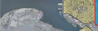
7 In the CMP, a deficiency plan is required whenever a freeway segment on the CMP system fails to meet the CMP Level of Service (LOS) standard and is designated as a deficient segment after allowing for certain statutory exclusions. Further, roadway segments designated as deficient segments should be grouped into common sub-areas or corridors based upon the following criteria: The segments are contiguous or share a common CMP route The segments are grouped near intersecting CMP routes The segments are included in a previously defined study area. In conjunction with Caltrans and SANDAG, the City of San Diego identified the facilities to be included in this FDP. While the detailed deficiency analysis conducted in the Traffic Analysis for the Ballpark and Ancillary Development Projects considered both local roadways and freeway facilities, the portions of the analysis summarized in the FDP relate only to the major CMP freeway routes. The segments analyzed in conjunction with the Ballpark and Ancillary Development Projects and included within this FDP are I-5 between Sea World Drive and SR-54, SR-163 between Genesee Avenue and I-5, SR-94 between 17 th Street and Massachusetts Avenue, and I-15 between I-805 and SR-94. E.2 Background and Purpose As stated above, the primary factor which required the preparation of this FDP was the mitigation requirement from the SEIR for the San Diego Ballpark Project. The discussion below provides background on this project and describes the linkage between the Ballpark Project and the Central I-5 Corridor Study. The planned Ballpark and Ancillary Development Projects are located in the East Village area of downtown San Diego. The proposed activities are to be located in an area roughly bounded by Sixth Avenue, Market Street, Interstate 5, and Commercial Avenue/Harbor Drive. The proposed construction consists of two basic components. The first, the Ballpark Project, is composed of a new ballpark and related retail, entertainment center, and parking facilities. The second component, the Ancillary Development Projects, consist of facilities around the Ballpark Project, including hotels, office, research and development, residential, and retail. For the Ballpark and Ancillary Development Projects traffic analysis, both non-event and event conditions were analyzed to determine resulting impacts. This FDP focuses on the non-event condition because event conditions would not occur on a regular daily basis, and the City of San Diego is developing a formal Event Traffic Management Plan (ETMP) to address the traffic generated by special events. To accomplish the SEIR mitigation requirement to prepare an FDP, SANDAG and the City of San Diego included the development of this plan as a scope element within the Work Program established for the Central I-5 Corridor Study. The Central I-5 Corridor Study was conducted under the direction of SANDAG and Caltrans, with participation by the Centre City Development Corporation (CCDC), the Metropolitan Transit Development Board (MTDB), the San Diego Unified Port District, and the cities of San 2
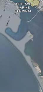
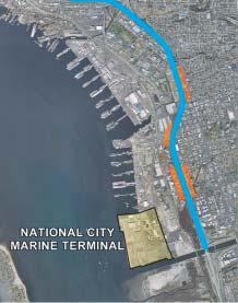
8 Diego, National City, and Chula Vista. The primary issues that led to initiation of the Central I-5 Corridor Study were related to access and mobility and the desire to enhance the economic vitality of the Corridor and the region as a whole. The purpose of the study was to identify shortrange and long-range actions to reduce traffic congestion on freeways, interchanges, and arterials that provide regional access to Centre City and other corridor activity centers, including San Diego International Airport (Lindbergh Field), the San Diego Unified Port District marine terminals at 10 th Avenue in San Diego and Bay Marina Drive in National City, and the Old Town Transit Center. As a component of the Central I-5 Corridor Study work program, this FDP was prepared under the direction of Caltrans, the City of San Diego, and SANDAG. The FDP is based in large part on the analysis in the Central I-5 Corridor Study. A Policy Committee, composed of staff and elected officials from local agencies and jurisdictions, met at key points during the Central I-5 Corridor study process to provide direction and guidance. Meetings with technical staff from the agencies and jurisdictions were also convened at periodic points in the study process to review analysis findings at a more technical level of detail. As part of the review process, the cities of San Diego and National City must approve the contents and recommendations of the FDP. Ultimately, this FDP must be accepted by SANDAG, acting as the Congestion Management Agency (CMA) for the San Diego region. The SEIR has stipulated that the FDP be accepted prior to the issuance of an occupancy permit by the City of San Diego for any ballpark-related development. E.3 FDP Methodology and Standards For the purpose of this FDP, the Ballpark Project SEIR Large Project traffic analysis provided a general guide in determining the extent of the influence area and the resulting freeway facilities to be included in this FDP analysis. Table E.1 lists each individual deficient freeway segment included in the FDP study area. This table also identifies the jurisdictional location of each FDP study segment. Inclusion in the FDP as a deficient freeway segment is triggered by either of two conditions: a. The segment has an existing LOS deficiency - i.e., LOS F. SANDAG has identified any freeway segments that currently operate at LOS F, and these segments are shaded in the column titled Year 1999 CMP LOS. b. The segment has been identified in a Large Project Traffic Analysis (i.e., San Diego Ballpark and Ancillary Development Projects and Associated Plan Amendments SEIR dated October 26, 1999) as experiencing a significant impact (future LOS F) due to the project. For the purposes of this FDP, this means that the traffic analysis for the Ballpark Project SEIR found the segment to be impacted by the project under either opening year (2002) or buildout non-event conditions. As shown in Table E.1, every freeway segment included in this FDP is projected to operate at LOS F in either the near term or buildout time frames. The table also indicates that a number of segments are triggered separately by each of the two criteria. 3
9 Table E.1 Summary of Existing and Future LOS Conditions Route Limits Jurisdiction Year 1999 Opening Year Non-Event Buildout Non-Event CMP LOS (1) Projected LOS (2) Projected LOS (2) I-5 Sea World Drive to I-8 City of San Diego E F F I-8 to Washington City of San Diego E F F Washington to Laurel City of San Diego E F F Laurel to SR-163 City of San Diego F F F SR-163 to SR-94 City of San Diego F E F SR-94 to Imperial City of San Diego F F F Imperial to Crosby City of San Diego F E F Crosby to 28 th Street City of San Diego E D F 28 th Street to I-15 City of San Diego F F F I-15 to 16 th Street City of San Diego/ National City F F F 16 th Street to SR-54 National City F F F SR-163 Genesee Avenue to Friars Road City of San Diego F F F SR-94 Friars Road to I-8 City of San Diego E F F I-8 to Washington City of San Diego F F F Washington to I-5 City of San Diego F F F 17 th Street to 28 th Street City of San Diego E F F 28 th Street to I-15 City of San Diego E F F I-15 to I-805 City of San Diego F F F I-805 to Euclid Avenue City of San Diego F F F Euclid Avenue to College Avenue City of San Diego/ Lemon Grove College Avenue to Massachusetts Avenue F F F Lemon Grove/La Mesa F F F I-15 I-805 to SR-94 City of San Diego C E F Notes: (1) (2) Source: URS, March Existing LOS conditions established by the SANDAG 1999 Congestion Management Program Update and based upon Year 1998 traffic data. Future LOS conditions derived from the Downtown San Diego Ballpark Traffic and Parking Studies, Project Traffic Study, Final Technical Report dated May E.4 Causes of Freeway Deficiencies As documented in the Central I-5 Corridor Study, existing and future year freeway deficiencies are a function of high levels of travel demand coupled with limited freeway capacity and outdated and/or substandard freeway geometrics. Corridor Travel Demands Travel demands are a result of population and employment growth both within the corridor and throughout the region. The following table displays existing year 2000 and forecast year 2020 population and employment projections for the study corridor and the region as a whole. 4
10 Regional and Central I-5 Corridor Population and Employment Projections Existing 2020 % Increase Over Existing Corridor Region Corridor Region Corridor Region Population 274,560 2,946, ,600 3,853, % 30.8% Employment 236,510 1,171, ,070 1,485, % 26.8% Source: SANDAG, Series 9, September As shown, population in the study corridor is projected to increase over existing levels by 32.4 percent by the year In addition, corridor employment is projected to increase 12.5 percent over existing levels by the year The following table displays the growth of office, retail, and housing within the Centre City, one of the primary focal points of growth in the Central I-5 Corridor. Centre City Growth Projections Development Type Amount Amount % Increase Over Existing Office (square feet) 11.8 million 18.1 million 52.8% Retail (square feet) 4.4 million 4.7 million 6.8% Housing Units 6,600 28, % Source: SANDAG, CCDC, September As shown, Centre City office space is projected to increase by 52.8 percent by the year 2020, with projected retail space in the Centre City increasing by 6.8 percent. The projected increase in Centre City housing units is very significant, from 6,600 units to 28,600 units by 2020, representing over a three-fold increase over the 20-year timeframe. This increase in Centre City housing units will be beneficial by reducing trip lengths and the number of work trips commuting from outside the corridor. The following table displays the projected number of person trips (work and non-work purposes) for the existing year 2000 and the forecast year 2020, along with the percentage growth over existing year 2000 levels. Purpose Daily Person Trips Central I-5 Corridor Existing Daily Corridor Person Trips Daily Corridor Person Trips % Increase Work 351, , % Non-Work 2,625,500 3,147, % Total 2,977,300 3,556, % Source: SANDAG, August
11 As shown, approximately 3.0 million trips currently take place in the corridor on a daily basis. By the year 2020, the number of trips will increase by 20 percent to 3.6 million. As expected, the vast majority of these trips have either an origin or destination within the corridor, with approximately 25 percent of the trips focused on the Centre City area. Less than 10 percent of the corridor s trips are through trips, or trips just passing through the corridor, between SR-54 and I-8. The I-5 freeway provides the primary regional access to the corridor s major activity centers, including Centre City, the airport, Old Town, and the marine terminals at Tenth Avenue and National City. The I-5 freeway also is a major connecting route to regional freeways, including SR-54, I-15, SR-94, SR-163, and I-8. Freeway Congestion In addition to the impacts associated with the population, employment, and development growth discussed above, congestion along the various freeway segments within the study area is generally a factor of the following: 1. Areas of capacity constraint wherein traffic flows exceed the carrying capacity of the freeway, as depicted by volume/capacity (v/c) relationships. The resulting high traffic densities restrict traffic flows, limit the ability to change lanes, and result in degraded travel speeds. Locations where capacity is reduced due to lane drops and termination of auxiliary lanes can be particular problems. 2. Merge and diverge conflicts at ramp junctions. At ramps, heavy volumes of merging vehicles entering the freeway traffic flows can create turbulence in the traffic flows. Approaching freeway vehicles must often shift lanes to the left to avoid this turbulence. Diverging vehicles at exit ramps also create turbulence, as exiting vehicles move right and through vehicles move left to avoid potential turbulence. 3. Deficient spacing between entry and exit ramps and corresponding poor weave section operations. The various weave merge and diverge movements cause turbulence which constrain traffic flow. Overall PM peak hour traffic flows on the I-5 freeway facility are constrained in the southbound direction generally between Pacific Highway in the north and SR-54 to the south. Major bottlenecks in the S curve through the downtown area occur due to merging and diverging traffic and heavy traffic flows to the South Bay. In a similar manner during the AM peak hour, northbound congestion occurs due to heavy traffic flows out of the South Bay and various conflicts with merging and weaving traffic. E.5 FDP Freeway Improvements Once the FDP deficient freeway segments were identified, it was necessary to identify a freeway improvement concept to mitigate the capacity deficiency of each segment. The improvement concept for the deficient freeway segments was derived from one of three sources: a. Improvements contained in the 2030 Regional Transportation Plan (RTP) Reasonably Expected Revenue (MOBILITY) Scenario. b. Additional improvement projects recommended in the Central I-5 Corridor Study. 6
12 c. Other Improvements to Achieve Minimum LOS E. Unlike Reasonably Expected improvements, these long-term projects are not included in the 2030 RTP and are unfunded at the present time. The FDP also includes operational and non-highway improvements which are discussed in a following section. Table E.2 summarizes the deficiencies which would be addressed by improvements contained in the 2030 RTP Reasonably Expected Revenue (MOBILITY) Scenario. This table also repeats the columns contained in Table E.1, and adds four new columns under the heading, 2030 RTP Reasonably Expected Revenue (MOBILITY) Scenario. The first column under this heading, Description of Improvement, summarizes the improvement concept, if any, proposed in the RTP. The next column provides an estimated cost to implement the identified improvement. The next two columns show the resulting AM and PM peak hour LOS by direction for the year 2030 (the time horizon of the SANDAG RTP). For seven of the segments with proposed improvements, the 2030 AM and PM peak LOS is acceptable in both directions. Eight segments on I-5, however, would still experience a directional LOS F during at least one peak period. Four segments of SR-163 (for which no improvements are listed in this table) also operate at LOS F. Each of the 12 failing segments is shaded in the appropriate columns. To achieve LOS E or better, these 12 segments on both I-5 and SR-163 would require additional improvement actions beyond those included in the 2030 RTP Reasonably Expected Revenue (MOBILITY) Scenario. Table E.3 summarizes the LOS results based upon implementation of the Central I-5 Corridor Study recommended improvements between Sea World Drive and SR-54, in addition to the 2030 RTP Reasonably Expected Revenue (MOBILITY) Scenario (Table E.2). The exception is on Interstate 5 itself, where the RTP and the Central I-5 Corridor Study both recommend adding two lanes, but with different functions. The Central I-5 Corridor Study recommended two general purpose lanes, while the RTP recommends two HOV lanes. SANDAG will conduct further analysis of the feasibility and costs of HOVs in this particular corridor. In either case, the additional two lanes on I-5 shown in Table E.2 are not repeated in Table E.3. Table E.3 also shows the estimated cost of each improvement project. As shown, all freeway segment deficiencies except those on SR-163 would be mitigated by improvement projects in a combination of the 2030 RTP Reasonably Expected Revenue (MOBILITY) Scenario and the Central I-5 Corridor Study. Table E.4 addresses the additional long-term improvements on SR-163. This table contains the same information found in the corresponding columns of Table E.1, with identification of other improvements which would result in a long-term LOS of E or better. As shown, widening of SR-163 would be necessary to address the existing and projected deficiencies. It is important to note that earlier studies determined that no widening of SR-163 will occur through Balboa Park due to environmental constraints and community concerns, and there is no recommendation to widen SR-163 between I-5 and Genesee Avenue at this time. 7
13 Route Limits Jurisdiction I-5 Table E.2 Summary of Freeway Deficiency Plan Analysis by Segment Proposed Improvements From 2030 RTP Reasonably Expected Revenue (MOBILITY) Scenario Year 1999 CMP LOS (1) Opening Year Non-Event Buildout Non- Event Sea World Drive to I-8 City of San Diego E F F 2030 RTP Reasonably Expected Revenue (MOBILITY) Scenario (3) Projected LOS (2) Projected LOS (2) Description of Improvement Cost ($M) New east-north and south-west freeway connectors at I-8 Construct 2 HOV Lanes $200 Resulting Level of Service AM LOS NB/SB or EB/WB C/C PM LOS NB/SB or EB/WB D/D I-8 to Washington City of San Diego E F F Construct 2 HOV Lanes E/C E/D SR-163 Washington to Laurel City of San Diego E F F Construct 2 HOV Lanes E/C E/D Laurel to SR-163 City of San Diego F F F Construct 2 HOV Lanes E/C E/F SR-163 to SR-94 City of San Diego F E F Construct 2 HOV Lanes F/B D/E SR-94 to Imperial City of San Diego F F F Construct 2 HOV Lanes F/D E/F Imperial to Crosby City of San Diego F E F Construct 2 HOV Lanes F/D C/F Crosby to 28 th Street City of San Diego E D F Construct 2 HOV Lanes F/C C/E 28 th Street to I-15 City of San Diego F F F Construct 2 HOV Lanes F/B C/F I-15 to 16 th Street City of San Diego/National City F F F Construct 2 HOV Lanes F/B D/F 16 th Street to SR-54 National City F F F Construct 2 HOV Lanes Genesee Avenue to Friars Road City of San Diego F F F n/a UNK (4) F/B C/E E/F D/F Friars Road to I-8 City of San Diego E F F n/a A/D B/F I-8 to Washington City of San Diego F F F n/a D/E E/F Washington to I-5 City of San Diego F F F n/a F/F F/F SR th Street to 28 th Street City of San Diego E F F Construct 2 HOV Lanes A/C D/B 28 th Street to I-15 City of San Diego E F F Construct 2 HOV Lanes A/C D/B I-15 to I-805 City of San Diego F F F Construct 2 HOV Lanes A/E C/C I-805 to Euclid Avenue City of San Diego F F F Construct 2 HOV Lanes $500 A/E E/C Euclid Avenue to City of San Diego/Lemon Grove F F F Construct 2 HOV Lanes College Avenue B/E D/C College Avenue to Lemon Grove/La Mesa F F F Construct 2 HOV Lanes Massachusetts Avenue B/D D/C I-15 I-805 to SR-94 City of San Diego C E F Construct 2 HOV Lanes $200 Construct new south-west and $150 east-north HOV connectors at B/B C/B SR 94 Source: SANDAG, March Notes: (1) Existing LOS conditions established by the SANDAG 1999 Congestion Management Program Update and based upon Year 1998 traffic data. (2) Future LOS conditions derived from the Downtown San Diego Ballpark Traffic and Parking Studies, Project Traffic Study, Final Technical Report dated May (3) Future recommended improvements and resulting LOS conditions derived from the 2030 RTP Reasonably Expected Revenue (MOBILITY) Scenario, Spring Gray shading highlights the segments that are anticipated to remain impacted after the implementation of the 2030 RTP Reasonably Expected Revenue (MOBILITY) Scenario. (4) UNK: Unknown at this time. Cost estimates for constructing the I-5 HOV lanes are not currently available.
14 Route Limits Jurisdiction I-5 Sea World Drive to I-8 City of San Diego I-8 to Washington City of San Diego Year 1999 CMP LOS (1) Table E.3 Summary of Freeway Deficiency Plan Analysis by Segment Proposed Improvements From Central I-5 Corridor Study Opening Year Non- Event Projected LOS (2) Buildout Non-Event Projected LOS (2) Central I-5Corridor Study Recommended Improvements (3) Resulting Year 2020 Level of Cost Service Description of Improvements $M AM LOS PM LOS NB/SB NB/SB Reconfigure Sea World Drive Interchange $5 E F F New SB-WB and EB-NB connectors at I-5/I-8, widen ramps at I-5/I-8 E F F $200 Reconfigure Old Town Ave and Washington St interchange $12 Old Towne Transit Center Access Improvements $30 Washington to Laurel City of San Diego E F F Airport Access Improvements $125 C/C D/D Laurel to SR-163 City of San Diego F F F Reconfigure First Ave/Hawthorne St interchange $10 D/C E/D SR-163 to SR-94 City of San Diego F E F Centre City Collector-Distributor System $177 E/B C/C B/C C/C C/C D/D SR-94 to Imperial Imperial to Crosby City of San Diego City of San Diego Centre City Collector-Distributor System $173 F F F D/B D/C Tenth Ave. Marine Terminal Access Improvements $160* F E F Tenth Ave. Marine Terminal Access Improvements $160* D/B D/C SR-163 Crosby to 28 th Street City of San Diego F D F Tenth Ave Marine Terminal Access Improvements $160* D/B D/C 28 th Street to I-15 City of San Diego E F F I-15 to 16 th Street City of San Diego/ National City F F F 16 th Street to SR-54 National City Genesee Avenue to Friars Road F F F New NB auxiliary lanes from SB-15 to National Ave and SB auxiliary lanes from 8 th St to Cleveland Ave New NB auxiliary lanes from 7 th /8 th Street to Division Street $30* Add 2 General Purpose Lanes (4) $60 New NB & SB auxiliary lanes between Bay Marina Drive and Harbor Drive City of San Diego F F F n/a $30* E/A B/E $30* Add 2 General Purpose Lanes (4) $70 Friars Road to I-8 City of San Diego E F F n/a A/D B/F I-8 to Washington City of San Diego F F F n/a D/E E/F Washington to I-5 City of San Diego F F F n/a F/F F/F Notes: (1) Existing LOS conditions established by the SANDAG 1999 Congestion Management Program Update and based upon Year 1998 traffic data. (2) Future LOS conditions derived from the Downtown San Diego Ballpark Traffic and Parking Studies, Project Traffic Study, Final Technical Report, dated May (3) Future recommended improvements and resulting LOS conditions derived from the Central I-5 Corridor Study, dated November (4) The Central I-5 Corridor Study recommends widening to accommodate two additional lanes on these segments, for a total of 12 lanes. * Costs provided are for entire corridor, not specific to the subject section. E/A E/A C/E B/D B/D D/F Source: URS, March 6, 2003.
15 Route Limits Jurisdiction Table E.4 Summary of Freeway Deficiency Plan Analysis for Remaining LOS F Segments After 2030 RTP and Central I-5 Corridor Study Improvement Opening Year Non-Event Buildout Non- Event Year 1999 CMP LOS (1) Projected LOS (2) Projected LOS (2) Description of Improvement Concept Improvements to Achieve Minimum LOS E (3) Resulting Ultimate Level of Service PM AM SR-163 I-5 to Washington City of San Diego F F F Widen to 6 lanes E or better E or better Washington to I-8 City of San Diego F F F Widen to 6 lanes (4) E or better E or better I-8 to Friars Road City of San Diego F F F Widen to 10 lanes E or better E or better Friars Road to City of San Diego F F F Genesee Avenue Widen to 10 lanes E or better E or better Source: URS, March 6, Notes: (1) Existing LOS conditions established by the SANDAG 1999 Congestion Management Program Update and based upon Year 1998 traffic data. (2) Future LOS conditions derived from the Downtown San Diego Ballpark Traffic and Parking Studies, Project Traffic Study, Final Technical Report dated May (3) Future concept improvements and resulting LOS conditions based upon requirements to achieve operating conditions of LOS E or better. No facility improvement cost estimate has been prepared nor is any widening planned. (4) Due to environmental and community concerns, the San Diego City Council removed any recommended improvements to SR-163 in the Ballpark Final SEIR.
16 E.6 FDP Operational and Non-Highway Improvements In addition to the highway capital improvements noted on Tables E.2 and E.3, the improvements derived from both the 2030 RTP Reasonably Expected Revenue (MOBILITY) Scenario and the Central I-5 Corridor Study also included a comprehensive set of freeway operational improvements, in addition to an expanded focus on alternative modes and travel demand management (TDM) strategies as follows: Mobility 2030 Regional Transit Vision (RTV) - The RTV, as a significant component of Mobility 2030, calls for a network of fast, flexible, reliable, and convenient transit services connecting the region s major employment and activity centers. The Mobility 2030 Plan includes an extensive network of managed/hov lanes on the highway system designed to accommodate transit services as well as carpools and vanpools. The plan also includes an emphasis on demand management strategies to reduce peak period travel and to change when and how people travel. New and/or improved transit routes as identified in the RTV within the FDP study area include: a. Increase in existing Coaster service b. Increase in existing and planned Blue Line Trolley service c. Mid-Coast from Old Town to Sorrento Mesa d. Old Town to Kearny Mesa via Mission Boulevard/Balboa Avenue e. Old Town to Kearny Mesa via Linda Vista f. Coronado and Centre City to Sorrento Mesa via Hillcrest/Genesee. Central I-5 Corridor Study In addition to improvements on I-5, the recommended plan includes a comprehensive set of corridor improvements incorporating a variety of multimodal options focused on improving access to key activity centers and enhancing mobility throughout the corridor, including: a. An extensive set of transit system improvements consistent with the Mobility 2030 RTV. b. Improvements to adjacent parallel arterials to facilitate more efficient utilization, including intersection enhancements and signal coordination. c. An extensive set of operational improvements including metering of freeway on-ramps, additional auxiliary lanes, and ramp interchange enhancements to improve freeway merge and diverge movements. d. Travel demand management (TDM) strategies, including implementing a Centre City TDM program for promotion of transit, rideshare, flextime, and telecommuting. 11
17 E.7 Summary of Identified Improvements The freeway projects identified to achieve acceptable levels of service are shown in Figure E-1. The legend indicates those projects that have been incorporated into the RTP and those that have not. Only those projects in the RTP are recommended at this time. Table E.5 summarizes the FDP triggers that apply to each freeway segment, identified longrange freeway capital improvements for each segment by source, and the year 2030 LOS that would result from implementation of the improvements, in addition to the operational and nonhighway improvements incorporated within both the Mobility 2030 and Central I-5 Corridor Study. Assuming that the improvements are technically and financially feasible, each identified deficient freeway segment would be improved to an acceptable LOS of E or better. Some of the non-rtp projects, including the Collector/Distributor Ramp System and the I-5/SR- 94 connector ramp, are listed in the plan because technical analysis identified them as means to alleviate congestion. Because of strong community objection based on potentially strong adverse impacts, neither the Collector/Distributor nor the I-5/SR-94 connector is recommended. The community also identified other potential options to relive Interstate 5, such as doubledecked construction, tunnels, vertical retaining walls, and a reverse clover leaf interchange with SR-94. All such alternatives should be considered in the future planning process, where they will be subjected to environmental review, available funding and community input. E.8 FDP Phasing Plan and Implementation Strategy Table E.6 provides an indication of the anticipated schedule for the phased implementation of the improvements recommended in the 2030 RTP Reasonably Expected Revenue (MOBILITY) Scenario. The table includes the planned HOV lanes and missing freeway to freeway connector ramps, with the timeframes shown based upon the Final RTP as adopted in March Details such as the phasing of the individual interchange and ramp proposals were not included in MOBILITY It is envisioned that future RTP updates will review the additionally recommended concepts from the Central I-5 Corridor Study and recommend projects for implementation based upon results of further environmental review, available funding, and input from the community. Funding and implementation of the recommended Deficiency Plan improvements will be a joint local and regional effort that will require the use of federal, state, regional, local, and private funding sources. Toward this end, National City and the City of San Diego will: Work with SANDAG through the RTP and Regional Transportation Improvement Program (RTIP) processes to advance and fund the recommended Deficiency Plan improvement projects. To the extent possible and using local or private funds, consider Deficiency Plan recommendations when developing annual and multi-year capital improvement programs. 12
18 Advocate and, to the extent possible, fund Transportation Demand Management and Transportation System Management strategies to provide interim congestion relief until longer-term Deficiency Plan recommendations can be implemented. Work with SANDAG to identify new funding sources and advocate the allocation of these funds for Deficiency Plan improvements. Work with SANDAG to implement new congestion mitigation strategies resulting from the study currently underway to develop a Toolbox of mitigation strategies to address congestion within the San Diego region. 13

19 Figure E-1 15
20 Table E.5 Summary of Freeway Segment Deficiencies and Identified Improvements Route I-5 Limits Year 1999 CMP LOS (1) Opening Year Non- Event Projected Buildout Non-Event Identified 2030 Improvements LOS (2) Projected LOS (2) 2030 RTP Reasonably Expected Revenue (MOBILITY) Scenario Sea World Drive to I-8 E F F Construct two HOV lanes; new E-N and S-W freeway connectors at I-8 Central I-5 Corridor Study Reconfigure Sea World Dr interchange; new S-W and E-N connectors at I-5/I-8; widen ramps at I-5/I-8 Resulting Level of Service (based upon implementation of all improvements) AM (NB/SB PM (NB/SB or EB/WB) or EB/WB) B/C C/C I-8 to Washington E F F Construct HOV lanes Reconfigure Old Town Ave & C/C D/D Washington St interchange; Old Town transit center access improvements Washington to Laurel E F F Construct HOV lanes Airport access improvements C/C D/D Laurel to SR-163 F F F Construct HOV lanes Reconfigure First Ave/Hawthorne St interchange SR-163 to SR-94 F E F Construct HOV lanes Centre City Collector-Distributor System SR-94 to Imperial F F F Construct HOV lanes 10 th Ave Marine Terminal access improvements Imperial to Crosby F E F Construct HOV lanes 10 th Ave Marine Terminal access improvements Crosby to 28 th Street E D F Construct HOV lanes 10 th Ave & National City Marine Terminal access improvements 28 th Street to I-15 F F F Construct HOV lanes New NB auxiliary lanes from SR-15 to National Ave & SB aux. lanes from 8 th St to Cleveland Ave I-15 to 16 th Street F F F Construct HOV lanes Add 2 General Purpose lanes; new NB auxiliary lanes from 7 th /8 th St to Division St 16 th Street to SR-54 F F F Construct HOV lanes Add 2 General Purpose lanes; new NB & SB auxiliary lanes between Bay Marina Dr & Harbor Dr D/C E/B D/B D/B D/B E/A E/A E/A E/D C/C D/C D/C D/C B/E B/D B/D
21 Route SR-163 Limits Year 1999 CMP LOS (1) Table E.5 (continued) Summary of Freeway Segment Deficiencies and Identified Improvements Opening Year Non- Event Projected LOS (2) Buildout Non-Event Projected LOS (2) Genesee Ave to Friars Rd F F F Friars Road to I-8 E F F I-8 to Washington F F F Washington to I-5 F F F 2030 RTP Reasonably Expected Revenue (MOBILITY) Scenario Identified 2030 Improvements Central I-5 Corridor Study Resulting Level of Service (based upon implementation of all improvements) AM (NB/SB or EB/WB) PM (NB/SB or EB/WB) No identified improvements No identified improvements n/a n/a SR th Street to 28 th Street E F F Construct HOV lanes 2030 Reasonably Expected Improvements 28 th Street to I-15 E F F Construct HOV lanes 2030 Reasonably Expected Improvements I-15 to I-805 F F F Construct HOV lanes 2030 Reasonably Expected Improvements I-805 to Euclid Avenue F F F Construct HOV lanes 2030 Reasonably Expected Improvements Euclid Ave to College F F F Construct HOV lanes 2030 Reasonably Expected Ave Improvements College Avenue to F F F Construct HOV lanes 2030 Reasonably Expected Massachusetts Avenue Improvements I-15 I-805 to SR-94 C E F Construct HOV lanes; construct new 2030 Reasonably Expected S-W & E-N HOV connectors at SR-94 Improvements Notes: (1) (2) Existing LOS conditions established by the SANDAG 1999 Congestion Management Program Update and based upon Year 1998 traffic data. Future LOS conditions derived from the Downtown San Diego Ballpark Traffic and Parking Studies, Project Traffic Study, Final Technical Report dated May A/C A/C A/E A/E B/E B/D B/B D/B D/B C/C E/C D/C D/C C/B Source: URS, March 6, 2003.
22 Table E.6 Freeway Deficiency Plan Recommended Improvement Phasing Plan Route Limits Recommended Implementation Recommended 2030 RTP Reasonably Expected Timeframe (Year) (2) Revenue (MOBILITY) Scenario Improvements (1) I-5 Sea World Drive to I-8 Construct 2 HOV lanes X Construct new E-N and S-W freeway connectors at I-8 X I-8 to Washington Construct 2 HOV lanes X Washington to Laurel Construct 2 HOV lanes X Laurel to SR-163 Construct 2 HOV lanes X SR-163 to SR-94 Construct 2 HOV lanes X SR-94 to Imperial Construct 2 HOV lanes X Imperial to Crosby Construct 2 HOV lanes X SR-163 SR-94 Crosby to 28 th Street Construct 2 HOV lanes X 28 th Street to I-15 Construct 2 HOV lanes X I-15 to 16 th Street Construct 2 HOV lanes X 16 th Street to SR-54 Construct 2 HOV lanes X Genesee Ave to Friars Rd Friars Road to I-8 I-8 to Washington Washington to I-5 No improvements recommended (3) (3) (3) 17 th Street to 28 th Street Construct 2 HOV lanes X 28 th Street to I-15 Construct 2 HOV lanes X I-15 to I-805 Construct 2 HOV lanes X I-805 to Euclid Avenue Construct 2 HOV lanes X Euclid Ave to College Ave Construct 2 HOV lanes X College Avenue to Massachusetts Avenue Construct 2 HOV lanes X I-15 I-805 to SR-94 Construct 2 HOV lanes X Construct new S-W & E-N HOV connectors at SR-94 X Source: URS, March 6, Notes: (1) (2) (3) For other recommended improvements listed in Tables E.3 and E.5 and not included in the 2030 RTP Reasonably Expected Revenue (MOBILITY) Scenario, Section 6.0 of the Central I-5 Corridor Study Draft Final Report dated November 2002 contains details related to the Implementation Process and Phasing Concept. Recommended implementation timeframe derived from the Final 2030 RTP Reasonably Expected Revenue (MOBILITY) Scenario, March No implementation timeframe for the improvements to SR-163 has been included and no widening is recommended.
23 The complete Freeway Deficiency Plan, Central Interstate 5 Corridor Study is located on SANDAG s Web site under Publications/Transportation/Roads and Highways.
Freeway Deficiency Plan Final. Central Interstate 5 Corridor Study
 Freeway Deficiency Plan Final Central Interstate 5 Corridor Study December 2003 Prepared for: San Diego Association of Governments 401 B Street, Suite 800 San Diego, CA 92101 Prepared by: 1615 Murray Canyon
I 5 South Multimodal Corridor Study. Appendix B. Issue Statement
 I 5 South Multimodal Corridor Study Appendix B I-5 SOUTH MULTIMODAL CORRIDOR STUDY ISSUE STATEMENT JUNE 5, 2009 PROJECT DESCRIPTION The goal of the Interstate 5 (I-5) South Multimodal Corridor Study is
3.12 TRAFFIC AND CIRCULATION
 3.12 TRAFFIC AND CIRCULATION 3.12 Transportation and Circulation This section of the Draft EIR analyzes the existing transportation system in the area and addresses the potential transportation and circulation
Appendix CBOS Preliminary Modeling Results
 The regional travel demand model is a four-step trip based travel behavior model that is consistent with the RTP and is utilized to project traffic volumes and travel times on the transportation network.
Orange County Transportation Authority
 Orange County Transportation Authority May 23, 2018 Keeping Orange County Moving Overview OCTA s FY 18-19 Budget SB 1 OC Streetcar Project I-405 Improvement Project I-5 Widening (SR-73 to El Toro) SR-55
Columbia River Crossing Investment Grade Traffic and Revenue Study
 Columbia River Crossing Investment Grade Traffic and Revenue Study Columbia River Crossing First Phase Project December 27, 2013 Image courtesy of CRC Project Office (Page Intentionally Left Blank) Table
INTERCHANGE JUSTIFICATION REPORT
 INTERCHANGE JUSTIFICATION REPORT for I-5/MARTIN WAY INTERCHANGE and I-5/MARVIN ROAD INTERCHANGE LACEY, WASHINGTON Prepared for: City of Lacey In association with FHWA & WSDOT Prepared by: H. W. Lochner,
TRANSPORTATION COMMITTEE
 San Diego Association of Governments TRANSPORTATION COMMITTEE July 15, 2011 AGENDA ITEM NO.: 1 Action Requested: APPROVE TRANSPORTATION COMMITTEE DISCUSSION AND ACTIONS MEETING OF JUNE 17, 2011 The meeting
Public comments, including those by Montecito Association, followed the presentations.
 On August 16 there were a set of briefings to MPC Commissioners on the Highway 101 HOV Lane project and related interchange improvements. Briefings were: 1. 101 HOV Lane Project Status/Cabrillo - Fred
Final Interchange Justification Report
 Final Interchange Justification Report Port of Tacoma Road Interchange with Interstate 5 Fife, Washington Submitted to City of Fife Fife, Washington February 2012 Submitted by BergerABAM 33301 Ninth Avenue
Orange County Transportation Authority
 Orange County Transportation Authority January 23, 2019 Keeping Orange County Moving Overview I-405 Improvement Project OC Streetcar Project I-5 Widening (SR-73 to El Toro) SR-55 (I-405 to I-5) I-5 (I-405
COMPREHENSIVE PLAN AMENDMENT STAFF REPORT AMENDMENT ROUND 12-2 BCC TRANSMITTAL PUBLIC HEARING, JULY 23, 2012
 Agenda Item: 3.C.1 COMPREHENSIVE PLAN AMENDMENT STAFF REPORT AMENDMENT ROUND 12-2 BCC TRANSMITTAL PUBLIC HEARING, JULY 23, 2012 I. General Data Project Name: Element: Congress Avenue Extension TIM & 2020
SUMMARY REPORT December 1999
 PORTLAND/VANCOUVER SUMMARY REPORT December 1999 THE FUTURE OF THE INTERSTATE 5 CORRIDOR Leadership Committee Vern Ryles, Chair Poppers Supply Peter Bennett K-Line Mike Bletko Fred Meyer Stores, Inc. Margaret
US-131/US-131BR Interchange Options Kalamazoo County
 US-131/US-131BR Interchange Options Kalamazoo County 1 PROBLEM 19 March 2015 The Kalamazoo County portion of US-131 was constructed in the early 1960s. The US-131 Business Route (BR) was constructed at
PUGET SOUND GATEWAY PROGRAM PHASE 1 OF THE SR 509 COMPLETION PROJECT. Environmental Justice Technical Report
 PUGET SOUND GATEWAY PROGRAM PHASE 1 OF THE SR 509 COMPLETION PROJECT Environmental Justice Technical Report Prepared for Washington State Department of Transportation Prepared by PRR October 2017 Table
CITY OF ELK GROVE CITY COUNCIL STAFF REPORT
 CITY OF ELK GROVE CITY COUNCIL STAFF REPORT AGENDA ITEM NO. 10.1 AGENDA TITLE: Adopt resolution authorizing the City Manager to Execute a Multi-Agency Memorandum of Understanding with Caltrans, SACOG,
Cross-Border Transportation
 Cross-Border Transportation Monterrey, Mexico May 8th & 9th, 2006 Pedro Orso-Delgado, Director Caltrans District 11 Outline California/Baja California Border Region Border Reality Trade Statistics Institutional
Open House Summary and Analysis. I-35 from Rundberg Lane to US 290E Austin District, Travis County
 Open House Summary and Analysis I-35 from Rundberg Lane to US 290E Austin District, Travis County OPEN HOUSE SUMMARY AND ANALYSIS Table of Contents Proposed Improvements... 1 Purpose and Need... 1 Notices
City of Los Alamitos
 City of Los Alamitos Agenda Report August 18, 2014, Consent Calendar Item No: 8F To: Mayor Gerri L. Graham- Mejia & Members of the City Council From: Subject: Bret M. Plumlee, City Manager Resolution of
Chapter 1. Introduction. 1.1 Background
 Chapter 1 Introduction 1.1 Background The California Department of Transportation approved the Final Environmental Impact Report/ Finding of No Significant Impact (EIR/FONSI) for the I-5 HOV/Truck Lanes
Torrey Pines Community Planning Board Boquita Drive, Del Mar, CA
 Torrey Pines Community Planning Board 14151 Boquita Drive, Del Mar, CA 92014 www.torreypinescommunity.org BOARD MEMBERS: Dennis E. Ridz, Chair, dennisridz@hotmail.com ; Noel Spaid, Vice Chair; Kenneth
Appendix B Disruption Scenarios Information and Maps. Pierce County
 Appendix B Disruption Scenarios Information and Maps Pierce County Transportation Recovery Annex February 2011 DISRUPTION SCENARIOS INFORMATION AND MAPS This page intentionally left blank Transportation
Environmental Justice Technical Report
 FINAL Environmental Justice Technical Report I-5 Rose Quarter Improvement Project January 8, 2019 Contents Acronyms and Abbreviations... iii Executive Summary... ES-1 1 Introduction...1 1.1 Project Location...1
Amendments to the Hampton Roads 2034 Long Range Transportation Plan. September 2014 Update
 Amendments to the Hampton Roads 2034 Long Range Transportation Plan September 2014 Update REPORT DOCUMENTATION TITLE: Amendments to the Hampton Roads 2034 Long Range Transportation Plan REPORT DATE: September
Only Establishment of a U.S. (Interstate) Route Action taken by SCOH: Extension of a U.S. (Interstate)Route
 Route Action taken by SCOH: Extension of a U.S. (Interstate)Route") American Association of State Highway and Transportation Officials An Application from the State Highway or Transportation Department of Colorado for: Elimination of a U.S. (Interstate) Route US 6 AASHTO
American Association of State Highway and Transportation Officials An Application from the State Highway or Transportation Department of Colorado for: Elimination of a U.S. (Interstate) Route US 6 AASHTO
Fwd: Council File: message
 Etta Armstrong Fwd: Council File: 13-1134 1 message Sharon Gin To: Etta Armstrong Tue, Oct 22, 2013 at 8:08 AM --------- Forwarded
I-5 Empire Project. 3 rd Annual. Community Open House. June 9, 2016
 I-5 Empire Project 3 rd Annual Community Open House June 9, 2016 Project Overview What: A series of improvements to I-5, local streets and the railroad tracks in Burbank between Magnolia Blvd. and Buena
Citizens Ray Chiaramonte, Ben Collier, Jim Flateau, Frank Havoer, Fred Krauer, Andy Padget, Georgianne Youngblood
 MOBILITY 2040: A Vision for the SR 54/56 Corridor Phase 1: Defining the Alternatives West Task Force Meeting Summary Tuesday, September 29, 2015 (5:30 pm 7:30 pm) Rasmussen College Room # 102 18600 Fernview
Orange County Transportation Issues Survey
 1 Orange County Transportation Issues Survey Val R. Smith, Ph.D. October 11, 2017 Methods: Field Dates: August 9-16, 2017 Sample Size: 1,590 completed interviews Sampling Error: 1,000-sample: +/- 3.1%
AASHTO Use Only Establishment of a U.S. (Interstate) Route I-22 Action taken by SCOH: Extension of a U.S. (Interstate)Route
 Route I-22 Action taken by SCOH: Extension of a U.S. (Interstate)Route") American Association of State Highway and Transportation Officials An Application from the State Highway or Transportation Department of Mississippi for: Elimination of a U.S. (Interstate) Route AASHTO
American Association of State Highway and Transportation Officials An Application from the State Highway or Transportation Department of Mississippi for: Elimination of a U.S. (Interstate) Route AASHTO
MARINE CORPS BASE CAMP PENDLETON
 MARINE CORPS BASE CAMP PENDLETON Base Overview Marine Corps Base Camp Pendleton (Camp Pendleton) is located in North San Diego County (Figure 1). It is the Marine Corps largest West Coast expeditionary
APPENDIX B. Environmental Justice Evaluation
 Appendix B. Environmental Justice Evaluation 1 APPENDIX B. Environmental Justice Evaluation Introduction The U.S. Department of Transportation has issued a final order on Environmental Justice. This final
Florida Senate CS for SB 360
 By the Committee on Community Affairs and Senators Bennett, Gaetz, Ring, Pruitt, Haridopolos, Richter, Hill, and King 1 2 3 4 5 6 7 8 9 10 11 12 13 14 15 16 17 18 19 20 21 22 23 24 25 26 27 28 29 A bill
Comment Letter No
 Comment Letter No. 6 6-1 Comment Letter No. 6 6-2 6-3 Comment Letter No. 6 6-3 6-4 6-5 6-6 Comment Letter No. 6 6-7 6-8 6-9 Comment Letter No. 6 6-10 Comment Letter No. 6 6-11 Comment Letter No. 6 6-11
Environmental Justice Analysis for Support of NEPA Documentation SEH No. HENNC
 MEMORANDUM TO: FROM: Jim Grube, Hennepin County Scott Pedersen, MnDOT Samuel Turrentine, AICP DATE: RE: Environmental Justice Analysis for Support of NEPA Documentation SEH No. HENNC 34 4.00 The purpose
APPENDIX D - APPENDIX E - APPENDIX F - APPENDIX G - APPENDIX H
 Appendices APPENDIX A - CROSSING VOLUMES AND WAIT TIMES APPENDIX B - DOCUMENT REVIEW APPENDIX C - STUDY AREA AND MAJOR DESTINATIONS APPENDIX D - NETWORK CONNECTIVITY ASSESSMENT APPENDIX E - NETWORK AMENITIES
PLANNING JUSTIFICATION REPORT
 PLANNING JUSTIFICATION REPORT SILVERCREEK JUNCTION 35 AND 40 SILVERCREEK PARKWAY, GUELPH Silvercreek Guelph Developments Ltd. Official Plan Amendment OP1201 Zoning Amendment Application ZC1204 May 7, 2012
)JY" /If'- Department of Transportation
JY /If'- Department of Transportation") CITY OF LOS ANGELES INTER-DEPARTMENTAL MEMORANDUM Date: June 10, 2015 To: From: 0 ~,A; Honorable City Council c/o City Clerk, Room 395, City Hall t tion: Honorable Mike Bonin, Chair, Transportation Committee
CITY OF LOS ANGELES INTER-DEPARTMENTAL MEMORANDUM Date: June 10, 2015 To: From: 0 ~,A; Honorable City Council c/o City Clerk, Room 395, City Hall t tion: Honorable Mike Bonin, Chair, Transportation Committee
POSSIBLE 2,000+ UNIT RESIDENTIAL / MULTI-USE ENTITLEMENT OPPORTUNITY 128 ACRES
 An Opportunity to Design a New Village Specific Plan Allows Various Uses & Densities Ocean and Downtown Views Offers Due Friday August 21, 2015 W UNITED STATES/MEXICO BORDER San Ysidro Middle School Las
Appendix B Disruption Scenarios Information and Maps. King County
 Appendix B Disruption Scenarios Information and Maps King County Transportation Recovery Annex June 2014 APPENDIX B DISRUPTION SCENARIOS INFORMATION AND MAPS This page intentionally left blank Transportation
HIGH CAPACITY TRANSIT CORRIDOR STUDY LYNNWOOD TO EVERETT FINAL REPORT JULY 2014 FINAL
 HIGH CAPACITY TRANSIT CORRIDOR STDY LYNNWOOD TO EERETT JLY 2014 FINAL FINAL REPORT Final to Everett High Capacity Transit Study Final Report Table of Contents Summary... S-1 Study Approach... S-2 Developing
MINUTES Highways Committee Meeting
 Committee Members Present Paul Glaab, Chairman Patricia Bates Carolyn Cavecche Don Hansen Allan Mansoor Shawn Nelson Curt Pringle Staff Present Will Kempton, Chief Executive Officer Darrell Johnson, Deputy
Call to Order. Invocation Vice Chairman Bates. Pledge of Allegiance Director Dixon
 Orange County Transportation Authority Board Meeting Orange County Transportation Authority Headquarters First Floor - Room 154, 600 South Main Street, Orange, California Monday, March 8, 2010, at 9:00
2017 Surrey Roads Survey JANUARY 2018
 2017 Surrey Roads Survey JANUARY 2018 In Partnership with BUSINESSINSURREY.COM Surrey Board of Trade WHO WE ARE The Surrey Board of Trade supports, promotes, and advocates for commercial and industrial
San Diego Regional Briefing I-5 South Realignment Communications Plan
 San Diego Regional Briefing I-5 South Realignment Communications Plan GSA Public Buildings Service 50 United Nations Plaza, San Francisco, CA www.gsa.gov 2 3 Project Overview PHASE 1E VATC WEST PED GSA
Summary of At-Border Data Collection Results
 Summary of At-Border Data Collection Results Economic and Air Quality/Climate Impacts of Delays at the Border San Diego, CA December 8, 2017 1 Contents Introduction... 4 Overview of the Study Area... 4
Marine Corps Base Camp Pendleton
 Marine Corps Base Camp Pendleton Marine Corps Base Camp Pendleton (Camp Pendleton) is located in North San Diego County, neighbored by the City of to the south, the community of Fallbrook to the east,
Economic Prosperity Element
 Economic Prosperity Element Economic Prosperity Purpose To increase wealth and the standard of living of all San Diegans with policies that support a diverse, innovative, competitive, entrepreneurial,
D R I I TEM #3
 Staff Report to the Municipal Planning Board April 21, 2015 D R I 2 0 1 5-0 0 0 0 2 I TEM #3 ORLANDO HEALTH DRI RESCISSION Location Map Subject Site S U M M A RY Owner Orlando Health, Inc. Applicant Jay
LOCAL LAW NO.: OF 2016
 LOCAL LAWS & ORDINANCES\Chapter 179 Zoning Commercial Intensive Exit 18 Zoning District 4-18-16 LOCAL LAW NO.: OF 2016 A LOCAL LAW TO AMEND CHAPTER 179 ZONING OF QUEENSBURY TOWN CODE TO ESTABLISH COMMERCIAL
COMMITTEE ON BINATIONAL REGIONAL OPPORTUNITIES
 San Diego Association of Governments COMMITTEE ON BINATIONAL REGIONAL OPPORTUNITIES September 4, 2018 AGENDA ITEM NO.: 7 Action Requested: INFORMATION 2017 SAN DIEGO BAJA CALIFORNIA BORDER CROSSING File
Congestion Management Program & Planning Committee MINUTES
 Congestion Management Program & Planning Committee CALL TO ORDER Thursday, April 19, 2018 MINUTES The Regular Meeting of the Congestion Management Program & Planning Committee (CMPP) was called to order
BOARD OF DIRECTORS AGENDA ITEM NO
 33 BOARD OF DIRECTORS AGENDA ITEM NO. 16-12-1 DECEMBER 16, 2016 ACTION REQUESTED APPROVE BOARD OF DIRECTORS DISCUSSION AND ACTIONS NOVEMBER 18, 2016 Chair Ron Roberts (Chair, County of San Diego) called
STAFF REPORT. Update regarding traffic congestion
 1 2 3 4 5 6 7 8 9 10 11 12 13 14 15 16 17 18 19 20 21 22 23 24 25 26 27 28 29 30 31 32 33 34 35 36 37 38 39 40 41 TO: FROM: SUBJECT: Mayor and City Council Jim McCann, City Manager OC~ Update regarding
MAIN COCONUT CREEK DRI
 RPM BSP ADA 1 MAIN STREET @ COCONUT CREEK DRI DEVELOPMENT OF REGIONAL IMPACT APPLICATION FOR DEVELOPMENT APPROVAL UNDER SECTION 380.06, FLORIDA STATUTES Revised September 2009 (SIN1) Revised November 2009
4-71. Tecate / Tecate. Ports of Entry Tecate Pedestrian/ Transit Facilities
 Figure 4.17: Roadway and Interchange and Non-Motorized Modes of Crossborder Travel Projects - Tecate-Tecate POE California-Baja California 2014 Border Master Plan Update Non-Motorized Facilties Interchange
23 USC 103. NB: This unofficial compilation of the U.S. Code is current as of Jan. 4, 2012 (see
 TITLE 23 - HIGHWAYS CHAPTER 1 - FEDERAL-AID HIGHWAYS 103. Federal-aid systems (a) In General. For the purposes of this title, the Federal-aid systems are the Interstate System and the National Highway
FINAL REPORT SAN DIEGO REGION-BAJA CALIFORNIA CROSS-BORDER TRANSPORTATION STUDY
 FINAL REPORT SAN DIEGO REGION-BAJA CALIFORNIA CROSS-BORDER TRANSPORTATION STUDY Prepared for SAN DIEGO ASSOCIATION OF GOVERNMENTS Prepared by PARSONS TRANSPORTATION GROUP In Association with CIC RESEARCH
Utah Transportation Commission Meeting Agenda Item Fact Sheet
 Utah Transportation Commission Meeting Agenda Item Fact Sheet Commission Meeting Date: December 15, 2017 Agenda Item #: 7A-1 Agenda Item Title: 2018 STIP Amendment #3 I-15 NB; 9000 South to I-215 Scope
Three Bridges. PDXScholar
 Portland State University PDXScholar TREC Friday Seminar Series Transportation Research and Education Center (TREC) 11-20-2015 Three Bridges Robert Liberty Portland State University Let us know how access
CITY OF TORONTO. BY-LAW No (OMB) To adopt Amendment No. 9 to the Official Plan for the former Borough of East York.
 To adopt Amendment No. 9 to the Official Plan for the former Borough of East York.") CITY OF TORONTO BY-LAW No. 879-2001(OMB) To adopt Amendment No. 9 to the Official Plan for the former Borough of East York. WHEREAS the Ontario Municipal Board pursuant to its Order No. 1898 dated December
CITY OF TORONTO BY-LAW No. 879-2001(OMB) To adopt Amendment No. 9 to the Official Plan for the former Borough of East York. WHEREAS the Ontario Municipal Board pursuant to its Order No. 1898 dated December
GEORGE MASSEY TUNNEL REPLACEMENT PROJECT PHASE 1 UNDERSTANDING THE NEED CONSULTATION SUMMARY REPORT MARCH 2013
 GEORGE MASSEY TUNNEL REPLACEMENT PROJECT PHASE 1 UNDERSTANDING THE NEED CONSULTATION SUMMARY REPORT MARCH 2013 This independent report of findings, including data entry and analysis of all the consultation
Boundary and Apportionment Plan
 2010 Boundary and Apportionment Plan October 2010 North Florida Transportation Planning Organization 1022 Prudential Drive, Jacksonville, Florida 32207 Tel 904.306.7500 Fax 904.306.7501 www.northfloridatpo.com
SURROUNDING COMMUNITY AGREEMENT RECITALS
 SURROUNDING COMMUNITY AGREEMENT THIS AGREEMENT (the Agreement ) is by and between Mohegan Sun Massachusetts, LLC, a Delaware limited liability company with its principal place of business at One Mohegan
AGEND. 9 a.m. to 12. San Diego UPDATE PROPOSED 2050 RTP REVIEW OF. Jack Dale, Chair Councilmember, Santee. County)
") Members Jack Dale, Chair Councilmember, Santee (Representing East County) Mattt Hall, Vice Chair Mayor, Carlsbad County Coastal) Jim Desmond Mayor, San Marcos County Inland) Carrie Downey Councilmember,
Members Jack Dale, Chair Councilmember, Santee (Representing East County) Mattt Hall, Vice Chair Mayor, Carlsbad County Coastal) Jim Desmond Mayor, San Marcos County Inland) Carrie Downey Councilmember,
TRANSPORTATION SERVICES DEPARTMENT
 ROAD CLOSURE POLICY CITY OF GRAND PRAIRIE TRANSPORTATION SERVICES DEPARTMENT APRIL, 1998 Mdword\road clorure\road closure policy ROAD CLOSURE POLICY CITY OF GRAND PRAIRIE Section 1. - General - It shall
STAFF REPORT CITY OF LAKE OSWEGO PLANNING AND BUILDING SERVICES DEPARTMENT
 STAFF REPORT CITY OF LAKE OSWEGO PLANNING AND BUILDING SERVICES DEPARTMENT APPLICANT City of Lake Oswego LOCATION Industrial Park (IP) Zone DATE OF REPORT January 31, 2017 FILE NO. LU 17-0002 STAFF Jessica
ANCHORAGE METROPOLITAN AREA TRANSPORTATION SOLUTIONS POLICY COMMITTEE MEETING
 POLICY COMMITTEE MEETING Planning & Development Center, Main Conference Room 4700 Elmore Road, 1st Floor Anchorage, Alaska 1:30 PM Members Present: Name Representing Dave Kemp Alaska Dept. of Transportation
YORK COUNTY GOVERNMENT
 MEMORANDUM TO: FROM: RE: DATE: June 20, 2016 York County Council York County Planning Commission Audra Miller, Planning Director YORK COUNTY GOVERNMENT Planning & Development Services Proposed Revisions
SBCAG STAFF REPORT. MEETING DATE: January 18, 2018 AGENDA ITEM: 6
 SBCAG STAFF REPORT SUBJECT: Committee Appointments MEETING DATE: January 18, 2018 AGENDA ITEM: 6 STAFF CONTACT: Marjie Kirn RECOMMENDATION: A. Appoint one delegate and one alternate to the California Association
Torrey Pines Community Planning Board
 Torrey Pines Community Planning Board 14151 Boquita Drive, Del Mar, CA 92014 www.torreypinescommunity.org BOARD MEMBERS: Dennis E. Ridz, Chair, dennisridz@hotmail.com ; Cathy Kenton, Vice Chair; Kenneth
Environmental Justice Methodology Technical Memorandum
 Appendix D Environmental Justice Methodology I-290 Eisenhower Expressway Cook County, Illinois Prepared For: Illinois Department of Transportation Prepared By: WSP Parsons Brinckerhoff September 2016 This
AMENDMENT RECORD AMC Title 20 Albany Development Code (Text Only)
") AMC Title 20 Albany Development Code (Text Only) September 25, 1981 4441 Adoption October 1, 1982 4528 Text Changes November 19, 1982 N/A LCDC Acknowledgement October 10, 1984 4648 Article 18: Signs October
AMC Title 20 Albany Development Code (Text Only) September 25, 1981 4441 Adoption October 1, 1982 4528 Text Changes November 19, 1982 N/A LCDC Acknowledgement October 10, 1984 4648 Article 18: Signs October
Area Year 2000 Year 2030 Change. Housing Units 3,137,047 4,120, % Housing Units 1,276,578 1,637, % Population 83,070 96,
 4.3 POPULATION, HOUSING AND ENVIRONMENTAL JUSTICE This section describes potential project-related impacts to population, housing and employment associated with the Canoga Transportation Corridor Project.
AGENDA CITIZEN S TRANSPORTATION ADVISORY COMMITTEE/ SOCIAL SERVICES TRANSPORTATION ADVISORY COUNCIL (CTAC/SSTAC)
") AGENDA CITIZEN S TRANSPORTATION ADVISORY COMMITTEE/ SOCIAL SERVICES TRANSPORTATION ADVISORY COUNCIL (CTAC/SSTAC) 1. CALL TO ORDER 2. SELF INTRODUCTIONS TUESDAY, NOVEMBER 13, 2018 -- 1:30 PM 3:30 PM County
AGENDA CITIZEN S TRANSPORTATION ADVISORY COMMITTEE/ SOCIAL SERVICES TRANSPORTATION ADVISORY COUNCIL (CTAC/SSTAC) 1. CALL TO ORDER 2. SELF INTRODUCTIONS TUESDAY, NOVEMBER 13, 2018 -- 1:30 PM 3:30 PM County
Explanation of the Application Form
 Explanation of the Application Form Code Explanation A. Details on the application A01A EU standard passport photograph, size 3.5 x 4.5 cm to 4 x 5 cm A01B Signature of applicant and/or legal representative
Improving Regional Mobility In South Orange County
 Improving Regional Mobility In South Orange County The Toll Roads 51 miles open 20 percent of OC freeway system 300,000 transactions per day $335M annual toll revenue All drivers pay electronically Built
LAREDO URBAN TRANSPORTATION STUDY
 LAREDO URBAN TRANSPORTATION STUDY METROPOLITAN PLANNING ORGANZIATION UPDATED: May 15, 2017 METROPOLITAN PLANNING ORGANIZATION This page intentionally left blank TABLE OF CONTENTS GENERAL...1 POLICY...1
A. CALL TO ORDER Chairman Wood called the meeting to order. He recognized that a quorum had been established.
 OKALOOSA-WALTON TRANSPORTATION PLANNING ORGANIZATION (TPO) MEETING MINUTES WEST FLORIDA REGIONAL PLANNING COUNCIL (Designated staff) NICEVILLE COMMUNITY CENTER, 204 N. Partin Drive; Niceville, FL March
RT AC Mission, Policies and Procedures
 .."'- ".- "" ', -.,""'c. RT AC Mission, Policies and Procedures I. CREATION OF THE RT AC The coalition, known as the Regional Transportation Agencies Coalition (RTAC), will be governed by the terms of
Survey Results Summary
 Survey Results Summary January 28, 2014 FINAL Introduction As part of the Public Outreach Task for VTrans 2040, an online survey was designed and administered to residents of the Commonwealth. The purpose
14. General functions, powers and duties of department. Effective: April 1, 2005
 14. General functions, powers and duties of department Effective: April 1, 2005 The department, by or through the commissioner or his duly authorized officer or employee, shall have the following general
Fredericksburg Area Metropolitan Planning Organization 2045 Long Range Transportation Planning Advisory Committee Meeting #7 Part 1 November 1, 2017
 Fredericksburg Area Metropolitan Planning Organization 2045 Long Range Transportation Planning Advisory Committee Meeting #7 Part 1 November 1, 2017 Committee Members Present: Mr. Erik Nelson, City of
6245 Gentry Ave. North Hollywood, CA 91606
 6245 Gentry Ave. North Hollywood, CA 91606 December 13, 2016 Planning and Land Use Management Committee Los Angeles City Hall 200 North Spring Street Los Angeles, CA 90012 Dear Sir or Madam, Please add
2025 COMPREHENSIVE PLAN PASCO COUNTY, FLORIDA
 CHAPTER 1 TABLE OF CONTENTS INTRODUCTION 1-1 Interpretation 1-2 Intent 1-2 Conflicting Policies 1-2 Zonings Approved Prior to the Pasco County Comprehensive Plan of 1991 (April 9, 1991) 1-3 Zonings Approved
MEETING OF THE SAN DIEGO METROPOLITAN TRANSIT SYSTEM EXECUTIVE COMMITTEE 1255 Imperial Avenue, Suite 1000 San Diego, CA
 A. ROLL CALL MEETING OF THE SAN DIEGO METROPOLITAN TRANSIT SYSTEM EXECUTIVE COMMITTEE 1255 Imperial Avenue, Suite 1000 San Diego, CA 92101 MINUTES Chair Gomez called the Executive Committee meeting to
TECHNICAL ADVISORY COMMITTEE AGENDA N. Imperial Ave., Suite 1 El Centro, CA 92243
 TECHNICAL ADVISORY COMMITTEE AGENDA DATE: Thursday, February 26, 2015 TIME: LOCATION: 10:00 a.m. 12:00 p.m. Offices 1405 N. Imperial Ave., Suite 1 El Centro, CA 92243 Chairperson: Bill Brunet, County of
HOUSE SPONSORSHIP. Bill Summary
 Second Regular Session Sixty-ninth General Assembly STATE OF COLORADO REENGROSSED This Version Includes All Amendments Adopted in the House of Introduction LLS NO. -0.0 Jason Gelender x0 SENATE BILL -
SAN DIEGO ASSOCIATION OF GOVERNMENTS BYLAWS ARTICLE I NAME AND PURPOSE
 SAN DIEGO ASSOCIATION OF GOVERNMENTS BYLAWS ARTICLE I NAME AND PURPOSE The name of this organization shall be the San Diego Association of Governments (hereinafter referred to as SANDAG). Section 2 The
VALLEY METRO RAIL PROJECTS UPDATE
 VALLEY METRO RAIL PROJECTS UPDATE Transportation Coordinator Webinar October 21, 2015 ShareTheRide.com 602.262.RIDE (7433) To hear us, turn up speakers or headset volume. Your microphone is muted. Ask
Community Organizations
 Community Organizations Letter FW155 Associated Students of Highline College, Ruth Krizan Page 1 Response to Comment LC9-1 Sound Transit has a formal process for naming stations that occurs during final
Policy Committee Meeting Minutes March 19,
 Policy Committee Meeting Minutes March 19, 2018 http://www.fampo.gwregion.org/committees/policy-committee/ Members Present: Mr. Mark Dudenhefer, Chair, Stafford County Mr. Tim Baroody, City of Fredericksburg
info Poverty in the San Diego Region SANDAG December 2013
 info December 2013 SANDAG Poverty in the San Diego Region Table of Contents Overview... 3 Background... 3 Federal Poverty Measurements... 4 Poverty Status for Individuals in the San Diego Region... 6 Demographic
U.S. 301 (State Road 200)
") U.S. 301 (State Road 200) C.R. 227 to C.R. 233 Bradford County, FL Florida Department of Transportation FM #208001-1 Welcome to the Public Hearing Project Development and Environment (PD&E) Study Starke
U.S. 301 (State Road 200) C.R. 227 to C.R. 233 Bradford County, FL Florida Department of Transportation FM #208001-1 Welcome to the Public Hearing Project Development and Environment (PD&E) Study Starke
Chapter 33G SERVICE CONCURRENCY MANAGEMENT PROGRAM
 Chapter 33G SERVICE CONCURRENCY MANAGEMENT PROGRAM Sec. 33G-1. Title. This chapter shall be known as the "Metro-Miami-Dade County Service Concurrency Management Program." (Ord. No. 89-66, 1, 7-11-89; Ord.
SETTLEMENT AGREEMENT This Settlement Agreement ( Agreement ) is made and entered into as of February 27, 2014 by and between Plaintiff/Petitioner
 is made and entered into as of February 27, 2014 by and between Plaintiff/Petitioner") SETTLEMENT AGREEMENT This Settlement Agreement ( Agreement ) is made and entered into as of February 27, 2014 by and between Plaintiff/Petitioner BUILDING INDUSTRY ASSOCIATION BAY AREA and Defendants/Respondents
SETTLEMENT AGREEMENT This Settlement Agreement ( Agreement ) is made and entered into as of February 27, 2014 by and between Plaintiff/Petitioner BUILDING INDUSTRY ASSOCIATION BAY AREA and Defendants/Respondents
1. Why is a New Border Crossing Needed?
 1. Why is a New Border Crossing Needed? Example of Freight Flows A new border crossing is needed to support the region, state, provincial and national economies while addressing the civil and national
Senate Bill No CHAPTER 743
 Senate Bill No. 1703 CHAPTER 743 An act to amend Section 29532.1 of the Government Code, and to amend Section 99233.5 of, and to add Chapter 3 (commencing with Section 132350) to Division 12.7 of, the
A Regional Transportation Plan for the Meramec Region
 A Regional Transportation Plan for the Meramec Region Including: Crawford, Dent, Gasconade, Maries, Osage, Phelps, Pulaski and Washington Counties June 2014 Completed by: Meramec Regional Planning Commission
SECTION 1 BACKGROUND. Chapter 1 Introduction
 SECTION 1 BACKGROUND Chapter 1 Introduction SECTION 1 BACKGROUND Chapter 1 Introduction 1.1 Overview The 1997 City of Thornton Comprehensive Plan identified the need to create Subarea Plans "to plan for