Microsoft Encarta Encyclopedia 2002.
|
|
|
- Julia Webster
- 6 years ago
- Views:
Transcription
1 Nauru Page 1 Nauru Nauru, also spelled Naoero, island and republic in the central Pacific Ocean, situated just south of the equator. It is a raised coral island, oval in shape, with an area of 21.2 sq km (8.2 sq mi). The population (2001 estimate) is 12,088. In the late 1980s the population was estimated to be made up of about 58 percent Nauruans, 26 percent other Pacific Islanders, 8 percent Chinese, and 8 percent Europeans. The Nauruans are of mixed Polynesian, Micronesian, and Melanesian origin. About fourfifths of the people are Christians. Nauruan and English are the main languages. Nauru does not have an official capital, but government offices are located in the district of Yaren. Most of the people of Nauru live along a narrow, fertile coastal strip that encircles the island. The rest of the island consists of a central plateau, about 60 m (about 200 ft) in elevation, that contains rich deposits of high-quality phosphate rock. In the mid-1980s approximately 1.6 million metric tons of phosphate were exported annually to Australia, New Zealand, the Philippines, South Korea, and Japan, primarily for use in the manufacture of fertilizer. In the early 1990s demand and export of phosphate rock declined, and in 1999 production was down to 600,000 metric tons. The Nauruans receive generous royalties for the mined phosphate, and this makes Nauru one of the richest, per capita, countries in the world. However, the phosphate mining has severely damaged the island s environment. Eighty percent of the island has been rendered uninhabitable. Native birds are threatened by habitat loss, and Nauru is now seeking international aid in order to rehabilitate its land. Because of the expected depletion of the phosphate deposits, the Nauruan government is investing abroad and attempting to develop service industries to ensure the country s economic future. Nauru was visited by the British in 1798 and annexed by Germany in 1888; it surrendered to Australian armed forces in It was occupied by the Japanese during World War II from 1942 until 1945, and in 1947 was placed under United Nations trusteeship, administered jointly by Australia, New Zealand, and the United Kingdom. Nauru gained its independence and was proclaimed a republic on January 31, Its unicameral parliament has 18 popularly elected members who serve terms of up to three years. Voting is compulsory for all citizens age 20 and older. The president, elected by parliament from among its members, is assisted by an appointed cabinet. Hammer DeRoburt became president upon independence, serving from 1968 to He was returned to the presidency in 1978 and was reelected in 1980, 1983, and In late 1989, after a period of political turmoil, Bernard Dowiyogo was elected president; he was reelected in The campaign for the November 1995 legislative elections was marked by allegations that the government had poorly managed royalties from the phosphate mining. In late November the new parliament elected Lagumot Harris to replace Dowiyogo as president. Political instability returned in 1996 and 1997, when parliament elected four presidents in less than three months. A new parliament, elected in February 1997, chose Kinza Clodumar as president, Nauru s fifth in less than a year. Nauru became a member of the United Nations in Microsoft Encarta Encyclopedia Microsoft Corporation. All rights reserved.
2 Nauru Facts and Figures Page 1 Nauru Facts and Figures BASIC FACTS Official name Capital Area Republic of Nauru No official capital; government offices in Yaren 21 sq km 8.2 sq mi PEOPLE Population Population growth Population growth rate Projected population in 2025 Projected population in 2050 Population density Urban/rural distribution Share urban Share rural Ethnic groups Nauruan Other Pacific Islander Chinese European 12,088 (2001 estimate) 2 percent (2001 estimate) 17,887 (2000 estimate) 22,696 (2000 estimate) 570 persons per sq km (2001 estimate) 1,477 persons per sq mi (2001 estimate) 100 percent (1999 estimate) 0 percent (1995 estimate) 58 percent 26 percent 8 percent 8 percent Languages Nauruan (official), English widely used in government and commerce Religious affiliations Christian Other 80 percent 20 percent HEALTH AND EDUCATION Life expectancy Total Female Male Infant mortality rate Population per physician Population per hospital bed Literacy rate Total Female Male Education expenditure as a share of gross national product (GNP) 61.2 years (2001 estimate) 64.9 years (2001 estimate) 57.7 years (2001 estimate) 11 deaths per 1,000 live births (2001 estimate)
3 Nauru Facts and Figures Page 2 Number of years of compulsory schooling 10 years (1998) Number of students per teacher, primary school 20 students per teacher (1997) GOVERNMENT Form of government Republic Voting qualifications Universal and compulsory at age 20 Constitution 31 January 1968 Armed forces Total number of military personnel Military expenditures as a share of gross domestic product (GDP) ECONOMY Gross domestic product (GDP, in U.S.$) GDP per capita (U.S.$) GDP by economic sector Agriculture, forestry, fishing Industry Services Employment Number of workers Workforce share of economic sector Agriculture, forestry, fishing Industry Services Unemployment rate National budget (U.S.$) Total revenue Total expenditure Monetary unit 1 Australian dollar ($A), consisting of 100 cents Major trade partners for exports Australia, New Zealand Major trade partners for imports Australia, United Kingdom, New Zealand, Japan ENERGY, COMMUNICATIONS, AND TRANSPORTATION Electricity production Electricity from thermal sources Electricity from hydroelectric sources Electricity from nuclear sources Electricity from geothermal, solar, and wind sources 100 percent (1999 estimate) 0 percent (1999 estimate) 0 percent (1999 estimate) 0 percent (1999 estimate) Number of radios per 1,000 people 609 (1997) Number of telephones per 1,000 people Number of televisions per 1,000 people 46 (1997 estimate)
4 Nauru Facts and Figures Page 3 Number of Internet hosts per 10,000 people Daily newspaper circulation per 1,000 people Number of motor vehicles per 1,000 people Paved road as a share of total roads SOURCES Basic Facts and People sections Area data are from the statistical bureaus of individual countries. Population, population growth rate, and population projections are from the United States Census Bureau, International Programs Center, International Data Base (IDB) ( Urban and rural population data are from the Food and Agriculture Organization (FAO) of the United Nations (UN), FAOSTAT database ( Largest cities population data and political divisions data are from the statistical bureaus of individual countries. Ethnic divisions and religion data are largely from the latest Central Intelligence Agency (CIA) World Factbook and from various country censuses and reports. Language data are largely from the Ethnologue, Languages of the World, Summer Institute of Linguistics International ( Health and Education section Life expectancy and infant mortality data are from the United States Census Bureau, International Programs Center, International database (IDB) ( Population per physician and population per hospital bed data are from the World Health Organization (WHO) ( Education data are from the United Nations Educational, Scientific and Cultural Organization (UNESCO) database ( Government section Government, independence, legislature, constitution, highest court, and voting qualifications data are largely from various government Web sites, the latest Europa World Yearbook, and the latest Central Intelligence Agency (CIA) World Factbook. The armed forces data is from Military Balance. Economy section Gross domestic product (GDP), GDP per capita, GDP by economic sectors, employment, and national budget data are from the World Bank database ( Monetary unit, agriculture, mining, manufacturing, exports, imports, and major trade partner information is from the latest Europa World Yearbook and various International Monetary Fund (IMF) publications. Energy, Communication, and Transportation section Electricity information is from the Energy Information Administration (EIA) database ( Radio, telephone, television, and newspaper information is from the United Nations Educational, Scientific and Cultural Organization (UNESCO) database ( Internet hosts, motor vehicles, and road data are from the World Bank database ( Note Figures may not total 100 percent due to rounding. Microsoft Encarta Encyclopedia Microsoft Corporation. All rights reserved.
5

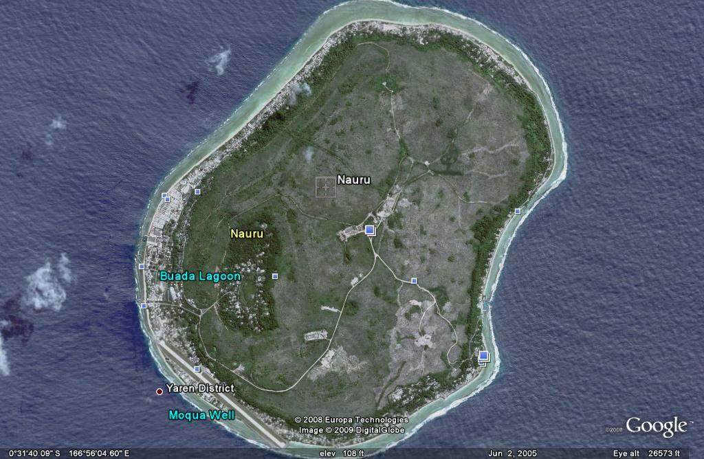
6 Detailed Map of Nauru Page 1 Microsoft Corporation. All Rights Reserved. Detailed Map of Nauru Microsoft Encarta Encyclopedia Microsoft Corporation. All rights reserved.

7 Beach on Nauru Page 1 Heldur Netocny/Panos Pictures Beach on Nauru Nauru, a small island country in the central Pacific Ocean, has the richest concentration of phosphate salt in the world. The phosphate is mined from a plateau on the island s interior and then refined in a treatment plant. Because Nauru has no harbor, a system of conveyor belts and cantilevers, background, is used to load the phosphate onto ships. Microsoft Encarta Encyclopedia Microsoft Corporation. All rights reserved.
8 limate information for Nauru - Climate Zone of 2 1/9/ :33 PM climate ZONE.com United States Alaska Great Plains Hawaii Mid-Atlantic Midwest Northeast Rocky Mountains South Southwest West World Map Continents Africa Asia Australia Europe Middle East North America Oceania South America Countries A-Z ABCDEF G H I J K L M N P R S T U V W Y Z Weather Books Hurricane Books Meteorology Books Tornado Books Weather Books Weather Instruments Hygrometers Outdoor Thermometers Rain Gauges Weather Stations World / Oceania / Nauru Nauru Average temperature, rainfall and snowfall information is available for the following climate stations in Nauru NAURU Official name: Capital: Area: Climate: Location: Geographic coordinates: Comparative Area: Land boundaries: Coastline: Terrain: Elevation extremes: Republic of Nauru no official capital; government offices in Yaren District total: 21 sq km water: 0 sq km land: 21 sq km tropical; monsoonal; rainy season (November to February) Oceania, island in the South Pacific Ocean, south of the Marshall Islands 0 32 S, E about 0.1 times the size of Washington, DC 0 km 30 km sandy beach rises to fertile ring around raised coral reefs with phosphate plateau in center lowest point: Pacific Ocean 0 m highest point: unnamed location along plateau rim 61 m Map of Nauru Nauru Looking for Nauru? Find exactly what you want today. Yahoo.com Nauru Flight Deals Super cheap tickets - lowest fares! Search all major sites in one place We Can Solve It Help the Alliance for Climate Protection Solve the Climate Crisis Storage In Chicago Looking for local storage units? Need storage? Call us today. gasstoragelansing.com

9 Climate information for Nauru - Climate Zone 2 of 2 1/9/ :33 PM Portions of this site are based on the CIA World Fact Book, a public-domain work All original material copyright 2004 climate-zone.com. All Rights Reserved. Privacy Policy Contact Us
10 GeoHive - Nauru statistics 1 of 1 1/9/ :46 PM General info Entity: Nauru Capital: no official capital Population ( ): 13,770 (CIA) Area: 21 sq.km. Country code: NR Region: Micronesia Nauru Administrative units administrative units capital area (sq.km.) population census Aiwo 1.1 1,072 Anabar Anetan Anibare Baitsi Boe Buada Denigomodu 0.9 2,548 Ewa Ijuw Meneng 3.1 1,269 Nibok Uaboe Yaren total ,919 source: "Book of the Year 2004", Encyclopedia Britannica. note: 1992 population count counted 6831 Nauruans and 3088 Non-Nauruans. CSS XHTML 1.1 GeoHive,
Microsoft Encarta Encyclopedia 2002.
 Page 1, archipelago, republic, central North Pacific Ocean. It consists of 34 islands in two groups: the southeastern Ratak Chain and the northwestern Ralik Chain. The chief industries are agriculture
: Information from the CIA World Factbook INTRODUCTION GEOGRAPHY
 COUNTRY DATA: Tuvalu : Information from the CIA World Factbook INTRODUCTION In 1974, ethnic differences within the British colony of the Gilbert and Ellice Islands caused the Polynesians of the Ellice
Location: Nearest Landmasses: Papua New Guinea (410 miles to the south) Philippines (550 miles to the west) Guam (815 miles to the northeast)
 Philippines (550 miles to the west) Guam (815 miles to the northeast)") Belau (Palau) Overview: The Republic of Belau is a sovereign nation in the westernmost part of Micronesia. Palau gained its independence October 1, 1994 with the entry into force of the Compact of Free
Belau (Palau) Overview: The Republic of Belau is a sovereign nation in the westernmost part of Micronesia. Palau gained its independence October 1, 1994 with the entry into force of the Compact of Free
Australia and Canada Unit Test-DO NOT WRITE ON THIS TEST
 Australia and Canada Unit Test-DO NOT WRITE ON THIS TEST 1. Which U-shaped rocky land covering is mineral rich and covers eastern and central Canada? A. Canadian Shield B. Rocky Mountains C. Lake Huron
COUNTRY DATA: UNITED KINGDOM: Information from the CIA World INTRODUCTION GEOGRAPHY
 COUNTRY DATA: UNITED KINGDOM: Information from the CIA World INTRODUCTION The United Kingdom has historically played a leading role in developing parliamentary democracy and in advancing literature and
(1) Overview of Japan 1-1) Land and Society
 Overview of Japan 1-1) Land and Society") (1) Overview of Japan 1-1) Land and Society a) Location and Physical Features Japan is an island nation situated off the eastern coast of the Asian continent. The nation s roughly 7,000 islands extend
(1) Overview of Japan 1-1) Land and Society a) Location and Physical Features Japan is an island nation situated off the eastern coast of the Asian continent. The nation s roughly 7,000 islands extend
Human Resources. There are 500 children in my How many. My village has 1,000 people. school. people do you think, there are in the whole world?
 Human Resources Do you know? The Government of India has a Ministry of Human Resource Development. The Ministry was created in 1985 with an aim to improve people s skills. This just shows how important
Goal 3: Promote Gender Equality and Empower Women
 98 Gender equality in primary school enrollment is high, with most economies having ratios of or more. This is also the case for gender equality in secondary school enrollment, but not so for tertiary
Central America and the Caribbean
 Chapter 11, Section World Geography Chapter 11 Central America and the Caribbean Copyright 2003 by Pearson Education, Inc., publishing as Prentice Hall, Upper Saddle River, NJ. All rights reserved. Chapter
Chapter 4 North America
 Chapter 4 North America Identifying the Boundaries Figure 4.1 The geographic center of North America is located near Rugby, North Dakota. Notice the flags of Mexico, Canada, and the United States. Source:
COUNTRY DATA: Lithuania : Information from the CIA World Factbook! INTRODUCTION
 ! COUNTRY DATA: Lithuania : Information from the CIA World Factbook! INTRODUCTION Lithuanian lands were united under MINDAUGAS in 1236; over the next century, through alliances and conquest, Lithuania
Singapore Introduction Background: Geography Location: Geographic coordinates: Map references: Area: Area - comparative:
 Singapore Introduction Background: Founded as a British trading colony in 1819, Singapore joined Malaysia in 1963, but withdrew two years later and became independent. It subsequently became one of the
Why Global Competence?
 Why Global Competence? Students want to know more about the world. Nine out of ten students want to know more about the rest of the world; they believe it will be important to their futures. Separate research
Australia-Oceania :: Tuvalu page last updated on November 25, 2009
 Australia-Oceania :: Tuvalu page last updated on November 25, 2009 Background: In 1974, ethnic differences within the British colony of the Gilbert and Ellice Islands caused the Polynesians of the Ellice
World Map Title Name. Russia. United States. Japan. Mexico. Philippines Nigeria. Brazil. Indonesia. Germany United Kingdom. Canada
 214 P Gersmehl Teachers may copy for use in their classrooms. Contact pgersmehl@gmail.com regarding permission for any other use. World Map Title Name Canada United States Mexico Colombia Ecuador Haiti
GREENPEACE INTERNATIONAL INDYACT 350.ORG
 EARTHJUSTICE NAURU ISLAND ASSOCIATION OF NGOS HUMAN RIGHTS ADVOCATES MANY STRONG VOICES GREENPEACE INTERNATIONAL INDYACT 350.ORG 5 July 2010 Office of the High Commissioner for Human Rights Palais Wilson,
Cambridge International Examinations Cambridge International General Certificate of Secondary Education
 Cambridge International Examinations Cambridge International General Certificate of Secondary Education *1305303660* ENVIRONMENTAL MANAGEMENT 0680/23 Paper 2 October/November 2016 1 hour 45 minutes Candidates
Globetrotters of the Philippines. Carmen Ong Mitchell Todd Reed Bailey Gary Haack Grant Sander
 Globetrotters of the Philippines Carmen Ong Mitchell Todd Reed Bailey Gary Haack Grant Sander AGENDA 1. Introduction 2. Geographic Location 3. Economy 4. Socioeconomic Factors 5. Financial Markets 6. Currency
REPORT NO. 19 NAURU: CLIMATE CHANGE AND MIGRATION RELATIONSHIPS BETWEEN HOUSEHOLD VULNERABILITY, HUMAN MOBILITY AND CLIMATE CHANGE.
 NAURU: CLIMATE CHANGE AND MIGRATION RELATIONSHIPS BETWEEN HOUSEHOLD VULNERABILITY, HUMAN MOBILITY AND CLIMATE CHANGE REPORT NO. 19 November 2016 JILLIAN CAMPBELL, ROBERT OAKES AND ANDREA MILAN This report
COUNTRY DATA: Togo : Information from the CIA World Factbook INTRODUCTION GEOGRAPHY
 COUNTRY DATA: Togo : Information from the CIA World Factbook INTRODUCTION French Togoland became Togo in 1960. Gen. Gnassingbe EYADEMA, installed as military ruler in 1967, ruled Togo with a heavy hand
What is Human Resource?
 Human Resources What is resource? What is Human Resource? Human Resource Human resources are the people who make up the workforce of an organization, business sector, or economy. People are a nation s
COUNTRY DATA: Indonesia : Information from the CIA World Factbook INTRODUCTION GEOGRAPHY
 COUNTRY DATA: Indonesia : Information from the CIA World Factbook INTRODUCTION The Dutch began to colonize Indonesia in the early 17th century; Japan occupied the islands from 1942 to 1945. Indonesia declared
COUNTRY DATA: Belgium : Information from the CIA World Factbook
 COUNTRY DATA: Belgium : Information from the CIA World Factbook INTRODUCTION Belgium became independent from the Netherlands in 1830; it was occupied by Germany during World Wars I and II. The country
Charting Singapore s Economy, 1Q 2016 Publication Date: December 8 th, 2015 Number of pages: 58
 Charting Singapore s Economy, 1Q 2016 Publication Date: December 8 th, 2015 Number of pages: 58 Attribution-NonCommercial-NoDerivatives 4.0 International (CC BY-NC-ND 4.0) You are free to: Share copy and
Pakistan 2.5 Europe 11.5 Bangladesh 2.0 Japan 1.8 Philippines 1.3 Viet Nam 1.2 Thailand 1.0
 173 People Snapshots Asia and the Pacific accounts for nearly 55% of global population and 6 of the world s 10 most populous economies. The region s population is forecast to grow by almost 1 billion by
Palestine in Figures 2011
 Palestine in Figures 2011 March, 2012 This document is prepared in accordance with the standard procedures stated in the Code of Practice for Palestine Official Statistics 2006. March, 2012 All rights
Name Chapter 4 TEKS. Subsistence Agriculture VS Market-Oriented (Commercial) Agriculture. by selling their products and then buy what they need
 Agriculture. by selling their products and then buy what they need") Name Chapter 4 TEKS Sequence Subsistence Agriculture VS Market-Oriented (Commercial) Agriculture Farming is done to meet the immediate family needs Labor force consists of a family or small group Family
Name Chapter 4 TEKS Sequence Subsistence Agriculture VS Market-Oriented (Commercial) Agriculture Farming is done to meet the immediate family needs Labor force consists of a family or small group Family
Guangxi Zhuang Autonomous Region 2013
 Guangxi Zhuang Autonomous Region 2013 By Sophie Lu LUP 011.8-3, Dec. 2013 Guangxi is the country s only area in the west which has a coastline and seaports. This region has the geographic advantage of
COUNTRY DATA: MALI : Information from the CIA World Factbook INTRODUCTION GEOGRAPHY
 COUNTRY DATA: MALI : Information from the CIA World Factbook INTRODUCTION The Sudanese Republic and Senegal became independent of France in 1960 as the Mali Federation. When Senegal withdrew after only
Ward profile information packs: Ryde North East
 % of Island population % of Island population Ward profile information packs: The information within this pack is designed to offer key data and information about this ward in a variety of subjects. It
Population. C.4. Research and development. In the Asian and Pacific region, China and Japan have the largest expenditures on R&D.
 Statistical Yearbook for Asia and the Pacific 2013 C. Education and knowledge C.4. (R&D) is a critical element in the transition towards a knowledgebased economy. It also contributes to increased productivity,
Investing in Skills for Domestic Employment or Migration? Observations from the Pacific Region
 Skills for Inclusive and Sustainable Growth in Developing Asia-Pacific: An International Forum 2012 Investing in Skills for Domestic Employment or Migration? Observations from the Pacific Region Sunhwa
Contents. Mini Almanac Primary Sources Library...988
 Contents.............................983 Primary Sources Library....................988 Honoring America: Flag Etiquette, The Star-Spangled Banner, The Pledge of Allegiance...................2 Glossary.................................3
COUNTRY DATA: Guatemala: Information from the CIA World Factbook INTRODUCTION GEOGRAPHY
 COUNTRY DATA: Guatemala: Information from the CIA World Factbook INTRODUCTION The Mayan civilization flourished in Guatemala and surrounding regions during the first millennium A.D. After almost three
INTRODUCTION GEOGRAPHY
 COUNTRY DATA: JORDAN : Information from the CIA World Factbook INTRODUCTION Following world war 1 and the dissolution of the Ottoman Empire, the UK received a mandate to govern much of the Middle East.
Contemporary Human Geography, 2e. Chapter 9. Development. Lectures. Karl Byrand, University of Wisconsin-Sheboygan Pearson Education, Inc.
 Contemporary Human Geography, 2e Lectures Chapter 9 Development Karl Byrand, University of Wisconsin-Sheboygan 9.1 Human Development Index Development The process of improving the material conditions of
Paper Reference. Paper Reference(s) 4370/1F London Examinations IGCSE Geography Foundation Tier
 4370/1F London Examinations IGCSE Geography Foundation Tier") Centre No. Candidate No. Surname Signature Paper Reference(s) 4370/1F London Examinations IGCSE Geography Foundation Tier Paper 1F Tuesday 11 November 2008 Morning Time: 1 hour 45 minutes Materials required
Centre No. Candidate No. Surname Signature Paper Reference(s) 4370/1F London Examinations IGCSE Geography Foundation Tier Paper 1F Tuesday 11 November 2008 Morning Time: 1 hour 45 minutes Materials required
Contemporary Human Geography
 Chapter 9 Lecture Contemporary Human Geography rd 3 Edition Chapter 9: Development Marc Healy Elgin Community College 9.1 Development Regions A developed country, also known as a More Developed Country
Where Does Level of Development Vary by Gender?
 288 The Cultural Landscape FIGURE 9-15 Developing regions with low HDIs: South Asia and sub-saharan Africa. (left) Sugarcane is transported by rickshaw to a wholesale market in Hyderabad, India. (right)
Goal 7. Ensure access to affordable, reliable, sustainable and modern energy for all
 Goal 7. Ensure access to affordable, reliable, sustainable and modern energy for all Table 4.1: Selected Indicators for SDG 7 - Energy Efficiency and Access to Modern and Renewable Energy Sources By 2030,
8. REGIONAL DISPARITIES IN GDP PER CAPITA
 8. REGIONAL DISPARITIES IN GDP PER CAPITA GDP per capita varies significantly among OECD countries (Figure 8.1). In 2003, GDP per capita in Luxembourg (USD 53 390) was more than double the OECD average
Immigration growth. Post-war migration
 Immigration growth Following Federation, the Federal Government passed laws that allowed Australia to decide, based on race, whether new migrants were suitable as residents of Australia. This legislation
MAPS. Environmental Issues. Economics Government History Pictures
 MAPS Environmental Issues Economics Government History Pictures 100 100 100 100 100 100 200 200 200 200 200 200 300 300 300 300 300 300 400 400 400 400 400 400 500 500 500 500 500 500 Q: 100 Which letter
Section - I. 1. If the Himalayas would have not been in its present position how would be the climatic conditions of the Indian sub continent?
 MAHA SAMKALPAM CHITTOOR DISTRICT SOCIAL STUDIES (Units 1,2,3 & 13, 14) (new syllabus) TEST - CYCLE 1, JANUARY 2016 Class : X (Max. Marks - 25) Time: 1 Hr PRINCIPLES OF VALUATION (ENGLISH VERSION) GENERAL
DEVELOPMENT AID IN NORTHEAST ASIA
 DEVELOPMENT AID IN NORTHEAST ASIA Sahiya Lhagva An Oven iew of Development Aid in Northeast Asia It is well known that Northeast Asia covers different economies which vary considerably in terms of economic
Socio-Economic Profile
 LOCAL HEALTH AREA 7 - Socio-Economic Profile Powell River Comox Cumberland Denman Island Hornby Island Qualicum CENSUS POPULATION LAND AREA POPULATION DENSITY Number % of Region Sq. Km. % of Region Persons
INTRODUCTION GEOGRAPHY
 COUNTRY DATA: NICARAGUA : Information from the CIA World Factbook INTRODUCTION The Pacific coast of Nicaragua was settled as a Spanish colony from Panama in the early 16th century. Independence from Spain
Lanna Culture and Social Development:
 Lanna Culture and Social Development: A Case Study of Chiangmai Province in Northern Thailand 1. Introduction By Phaisal Lekuthai Thailand is situated in the Southeast Asian mainland, the latitude 6-21
LESSON 4 The Miracle on the Han: Economic Currents
 The Miracle on the Han: Economic Currents Like other countries, Korea has experienced vast social, economic and political changes as it moved from an agricultural society to an industrial one. As a traditionally
c01.qxd 12/21/01 1:17 PM Page 3 The United States as a Nation
 c01.qxd 12/21/01 1:17 PM Page 3 P a r t I The United States as a Nation c01.qxd 12/21/01 1:17 PM Page 4 c01.qxd 12/21/01 1:17 PM Page 5 Where in the world is the United States of America? Where is the
Ministry of Trade and Industry Republic of Trinidad and Tobago SMALL STATES IN TRANSITION FROM VULNERABILITY TO COMPETITIVENESS SAMOA
 Ministry of Trade and Industry Republic of Trinidad and Tobago Commonwealth Secretariat SMALL STATES IN TRANSITION FROM VULNERABILITY TO COMPETITIVENESS SAMOA DEVELOPING COMPETITIVE ADVANTAGE THROUGH SERVICES
Economic Geography Chapter 10 Development
 Economic Geography Chapter 10 Development Development: Key Issues 1. Why Does Development Vary Among Countries? 2. Where Are Inequalities in Development Found? 3. Why Do Countries Face Challenges to Development?
Unit Six: West African Nations in the 21 st Century Global Marketplace
 Unit Six: West African Nations in the 21 st Century Global Marketplace Grade Level: Grades 6-12 National History Standards: Era 9: Standard 2A The student understands how population explosion and environmental
2016 Statistical Yearbook. Republic of Palau Bureau of Budget and Planning Ministry of Finance
 2016 Statistical Yearbook Republic of Palau Bureau of Budget and Planning Ministry of Finance REPUBLIC OF PALAU Office of the Minister ELBUCHEL SADANG Minister Message from the Minister of Finance I am
5th Social Studies practice test
 Name: Instructions: Bubble in the correct answer. Read all choices before marking your answer. Copyright 2000-2002 Measured Progress, All Rights Reserved : 1. Which of the following was developed during
Chapter 9. East Asia
 Chapter 9 East Asia Map of East Asia Figure 9.1 I. THE GEOGRAPHIC SETTING Differences in language make translation difficult Recent change to Pinyin spelling produced new place names Pinyin: spelling system
Measures of Development HDI
 Measures of Development HDI Big Mac Index and Purchasing Power Parity A method of measuring the relative purchasing power of different countries' currencies over the same types of goods and services. Because
Dooly County Middle School. Social Studies Georgia Standards of Excellent. 6 th Grade (July 31, 2017-Oct. 2, 2017) First 9 Weeks
 First 9 Weeks") Unit 1: Connecting Themes Dooly County Middle School Social Studies Georgia Standards of Excellent 6 th Grade Social Studies GSE Pacing Guide 2017-2018 6 th Grade (July 31, 2017-Oct. 2, 2017) First 9 Weeks
Unit 1: Connecting Themes Dooly County Middle School Social Studies Georgia Standards of Excellent 6 th Grade Social Studies GSE Pacing Guide 2017-2018 6 th Grade (July 31, 2017-Oct. 2, 2017) First 9 Weeks
How does development vary amongst regions? How can countries promote development? What are future challenges for development?
 Chapter 9- Development How does development vary amongst regions? How can countries promote development? What are future challenges for development? Human Development Index (HDI) Development process of
SEC. 2. CONSERVATION AND REINVESTMENT ACT FUND.
 Strike all after the enacting clause and insert the following: SECTION. SHORT TITLE. This Act may be cited as the Conservation and Reinvestment Act. SEC.. CONSERVATION AND REINVESTMENT ACT FUND. (a) ESTABLISHMENT
1. Economy. Economic Aggregates. Foreign Trade. Prices. Financial Statistics. Government Finance. Wages and Compensation. Foreign Investment
 1. Economy Economic Aggregates Foreign Trade Prices Financial Statistics Government Finance Wages and Compensation Foreign Investment GDP at Current Prices, Abu Dhabi Emirate, 2014* Non-oil GDP 952,676
3 1-1 GDP GDP growth rate Population size Labor force Labor participation rate Employed population
 INDEX Overview: Thailand 2 1 Economy 3 1-1 GDP 3 1-2 GDP growth rate 5 2 Population 6 2-1 Population size 6 3 Labor force and the related statistics 9 3-1 Labor force 10 3-2 Labor participation rate 12
APPLICANT INFORMATION PACKAGE
 APPLICANT INFORMATION PACKAGE FISHERIES MANAGEMENT ADVISOR CLOSING DATE 19 SEPTEMBER 2016 HOW TO APPLY - Please read the instructions contained in this package To apply please submit the following: (a)
An Overview of the Chinese Economy Foundation Part: Macro-economy of the Mainland
 Core Module 15 An Overview of the Chinese Economy Foundation Part: Macro-economy of the Mainland The Chinese economy has been growing rapidly for years. Has it reached the level of the developed countries?
CHAPTER I: SIZE AND GEOGRAPHICAL DISTRIBUTION OF THE POPULATION
 CHAPTER I: SIZE AND GEOGRAPHICAL DISTRIBUTION OF THE POPULATION 1. Trends in the Population of Japan The population of Japan is 127.77 million. It increased by 0.7% over the five-year period, the lowest
Key Issues: Climate Zone: As: Tropical humid. Subjects: - Restoration of livelihood and Rebuilding of Resettled Communities
 IEA Hydropower Implementing Agreement Annex VIII Hydropower Good Practices: Environmental Mitigation Measures and Benefits Case Study 07-01: Resettlement - Chiew Larn Multipurpose Project, Thailand Key
HOLT, RINEHART AND WINSTON
 CHAPTER 8 The United States Section 1: History and Culture Section 2: Regions of the United States Section 3: Geographic Issues 1, RINEHART AND WINSTON Section 1 History and Culture Objectives: What are
GDP per capita was lowest in the Czech Republic and the Republic of Korea. For more details, see page 3.
 International Comparisons of GDP per Capita and per Hour, 1960 9 Division of International Labor Comparisons October 21, 2010 Table of Contents Introduction.2 Charts...3 Tables...9 Technical Notes.. 18
photo: Typhoon Haiyan: What Happened & What s Next
 photo: www.care.org Typhoon Haiyan: What Happened & What s Next Prepared by David Shirk, Department of Political Science & International Relations, November 26, 2013 Overview Typhoon Haiyan Impacts Responses
Brazil, Cuba & Mexico
 Brazil, Cuba & Mexico Standards SS6E1 Analyze different economic systems. a. Compare how traditional, command, and market economies answer the economic questions of 1-what to produce, 2- how to produce,
Development. Differences Between Countries
 Development Between Countries Inequalities Between Developing Countries [Date] Today I will: - Know the reasons why there are differences between developing countries. There are over 100 Developing countries.
NEW ZEALAND IN PROFILE. An overview of New Zealand s people, economy, and environment
 NEW ZEALAND IN PROFILE 2015 An overview of New Zealand s people, economy, and environment ABOUT NEW ZEALAND Mäori name Aotearoa Capital Wellington Largest city Auckland Official languages English Mäori
Setting up in Denmark
 Setting up in Denmark 1. Denmark and the Danes Denmark is an attractive northern European country that offers many advantages to foreign investors. It is one of the 25 member states of the European Union
CHINA MARKET PROFILE. The Demographics
 CHINA MARKET PROFILE The Demographics In 2004, China, the most populous country in the world, had a total population of 1,298,847,624 (July 2004) one-fifth of the world s total. The population density
24 Negocios infographics oldemar. Mexico Means
 2 Negocios infographics oldemar Mexico Means Mexico s Means Partner opportunity enersave OPPORTUNITY 2 Negocios INFOGRAPHICS OLDEMAR MEET MEXICO MEXICO IS A big country Mexico is part of North America,
STOCKHOLM. Yearbook: Summary Results 232
 STOCKHOLM Stockholm is the capital city of Sweden, located on 15 islands where Lake Mälaren enters the Baltic Sea. Stockholm is the centre of an urban region with a population of approximately 1,760,000,
Chapter 18 Development and Globalization
 Chapter 18 Development and Globalization 1. Levels of Development 2. Issues in Development 3. Economies in Transition 4. Challenges of Globalization Do the benefits of economic development outweigh the
COUNTRY DATA: RWANDA: Information from the CIA World Factbook INTRODUCTION GEOGRAPHY
 COUNTRY DATA: RWANDA: Information from the CIA World Factbook INTRODUCTION In 1959, three years before independence from Belgium, the majority ethnic group, the Hutus, overthrew the ruling Tutsi king.
CANADA. Our big neighbor to the north.
 CANADA Our big neighbor to the north. CANADA VIDEO Geography made us neighbors, history made us friends, economics made us partners, and necessity made us allies. -JF Kennedy WELCOME TO CANADA Welcome
Commonwealth of the Northern Mariana Islands (CNMI) Northern Marianas College Cooperative Research Extension and Education Service (NMC-CREES)
 Northern Marianas College Cooperative Research Extension and Education Service (NMC-CREES)") Commonwealth of the Northern Mariana Islands (CNMI) Northern Marianas College Cooperative Research Extension and Education Service (NMC-CREES) Prepared by: Patricia Coleman and Rose Castro Narrated by:
Commonwealth of the Northern Mariana Islands (CNMI) Northern Marianas College Cooperative Research Extension and Education Service (NMC-CREES) Prepared by: Patricia Coleman and Rose Castro Narrated by:
Population & Migration
 Population & Migration Population Distribution Humans are not distributed evenly across the earth. Geographers identify regions of Earth s surface where population is clustered and regions where it is
Demography. Demography is the study of human population. Population is a dynamic open systems with inputs, processes and outputs.
 Population Demography Demography is the study of human population. Population is a dynamic open systems with inputs, processes and outputs. This means that change constantly occurs in population numbers,
Population & Migration
 Population & Migration Population Distribution Humans are not distributed evenly across the earth. Geographers identify regions of Earth s surface where population is clustered and regions where it is
MIGRATION BETWEEN THE ASIA-PACIFIC AND AUSTRALIA A DEVELOPMENT PERSPECTIVE
 MIGRATION BETWEEN THE ASIA-PACIFIC AND AUSTRALIA A DEVELOPMENT PERSPECTIVE by Graeme Hugo University Professorial Research Fellow Professor of Geography and Director of the National Centre for Social Applications
Contents. Acknowledgements...xii Leading facts and indicators...xiv Acronyms and abbreviations...xvi Map: Pacific region, Marshall Islands...
 Contents Acknowledgements...xii Leading facts and indicators...xiv Acronyms and abbreviations...xvi Map: Pacific region, Marshall Islands... xii CHAPTER 1: CENSUS ORGANIZATION AND OPERATIONS...1 CHAPTER
World Geography Final Exam Review Guide
 Name: Hour: Day: Unit 1: Exploring Geography World Geography Final Exam Review Guide 1. Identify and describe THREE types of technology that geographers use? 2. Define each of the following: Longitude:
MEETING THE NEED FOR PERSONAL MOBILITY. A. World and regional population growth and distribution
 30 II. MEETING THE NEED FOR PERSONAL MOBILITY A. World and regional population growth and distribution The world population grew at an annual rate of 1.4 per cent between 1990 and 2000. This is slightly
ISSUES and CHALLENGES for the ASIA and PACIFIC REGION. by Charles E. Morrison, East-West Center
 ISSUES and CHALLENGES for the ASIA and PACIFIC REGION by Charles E. Morrison, East-West Center East Asian Population People (millions) 1800 1600 1400 1200 1000 800 600 400 200 0 1950 1975 2000 2025 2050
Chapter 7. Migration
 Chapter 7 Migration Chapter 7 Migration Americans have traditionally been highly higher levels of educational attainment than Figure 7-1. mobile, with nearly 1 in 7 people changing residence each year.
Human Development Indices and Indicators: 2018 Statistical Update. Indonesia
 Human Development Indices and Indicators: 2018 Statistical Update Briefing note for countries on the 2018 Statistical Update Introduction Indonesia This briefing note is organized into ten sections. The
Unit 1 Test (Version B)
") Unit 1 Test (Version B) 1. The city of Lewisville has a population of 1,000 people living in 100 square miles. What is the population density of Lewisville? a. 10 people per square mile b. 50 people per
Unit 1 Test (Version B) 1. The city of Lewisville has a population of 1,000 people living in 100 square miles. What is the population density of Lewisville? a. 10 people per square mile b. 50 people per
INTERNATIONAL GENDER PERSPECTIVE
 Chapter 7 INTERNATIONAL GENDER PERSPECTIVE OF DEVELOPMENT INDICATORS Women & Men In India 2016 115 116 International Gender Perspective International Gender Perspective of Development Indicators India
October 2006 APB Globalization: Benefits and Costs
 October 2006 APB 06-04 Globalization: Benefits and Costs Put simply, globalization involves increasing integration of economies around the world from the national to the most local levels, involving trade
ASEAN. Statistical Yearbook. The ASEAN Secretariat Jakarta
 ASEAN Statistical Yearbook The ASEAN Secretariat Jakarta The Association of Southeast Asian Nations (ASEAN) was established on 8 August 1967. The members of the Association are Brunei Darussalam, Cambodia,
The Demographic Profile of Qatar
 UNITED NATIONS The Demographic Profile of Qatar Population Trends - Mortality - Fertility - Age Structure - Urbanization - International Migration - Education and Youth Unemployment Population Trends Population
Summary of the Results
 Summary of the Results CHAPTER I: SIZE AND GEOGRAPHICAL DISTRIBUTION OF THE POPULATION 1. Trends in the Population of Japan The population of Japan is 127.77 million. It increased by 0.7% over the five-year
ASIA: Reading & Writing, 5/12 & 5/13
 ASIA: Reading & Writing, 5/12 & 5/13 Name: To finish our unit on Asia, we will read 2 magazine articles and examine 5 country profiles! Hurray! You are responsible for reading all of the pieces at your
European Union : dynamics and development of the territories of Europe
 European Union : dynamics and development of the territories of Europe What are the features of the European space? Why is it said to be a specific territory? Europe, Europes? A continent between unity
FY 2005 Liaison Meeting - JILPT International Labor Information Project
 FY 2005 Liaison Meeting - JILPT International Labor Information Project November 7-10, 2005 Tokyo, Japan Policies and Systems for Foreign Workers in Asian Countries: With a Special Reference To The Thai
TOPICS INCLUDE: Population Growth Demographic Data Rule of 70 Age-Structure Pyramids Impact of Growth UNIT 3: POPULATION
 TOPICS INCLUDE: Population Growth Demographic Data Rule of 70 Age-Structure Pyramids Impact of Growth UNIT 3: POPULATION # of individuals in a given area Uniform equally spaced Clumped/Clustered individuals