Central America and the Caribbean
|
|
|
- Angelina Waters
- 6 years ago
- Views:
Transcription

1 Chapter 11, Section World Geography Chapter 11 Central America and the Caribbean Copyright 2003 by Pearson Education, Inc., publishing as Prentice Hall, Upper Saddle River, NJ. All rights reserved.
2 Chapter 11, Section World Geography Chapter 11: Central America and the Caribbean Section 1: Central America Section 2: The Caribbean Islands Copyright 2003 by Pearson Education, Inc., publishing as Prentice Hall, Upper Saddle River, NJ. All rights reserved.


3 Chapter 11, Section 1 Central America What are the major landforms and climates of Central America? What peoples and cultures are found in Central America? How have social and economic conditions sometimes led to political conflicts in the nations of Central America?
4 Chapter 11, Section 1 Landforms and Climates Central America is an isthmus, a narrow strip of land that connects two larger bodies of land. High, rugged mountainous core runs the length of Central America, with many active volcanoes. Two climate zones exist at high elevations. The Caribbean lowlands on the eastern side of Central America have a tropical wet climate and dense rain forest vegetation. The Pacific coastal plain has a tropical wet climate with savanna vegetation made fertile by lava flows and volcanic ash. Devastating tropical storms and hurricanes can strike in the summer and early fall.
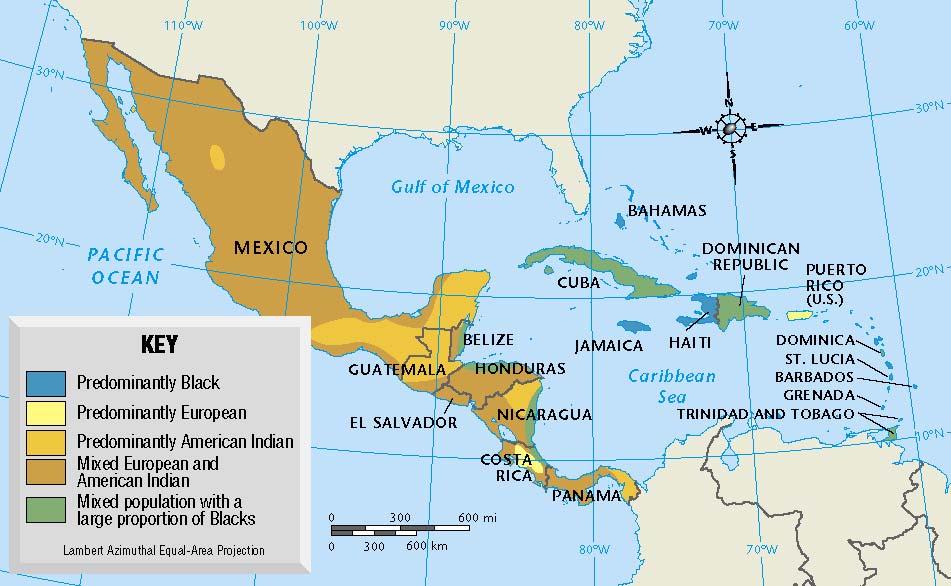
5 Chapter 11, Section 1 People and Cultures Central America is home to several ethnic groups. Indians Indian groups, each with its own separate and distinct culture, have lived the longest in Central America. Europeans The first Europeans arrived in the 1500s as conquerors and colonists. Mestizos Mestizos, or people of mixed European and Indian descent, make up a large part of the population. Africans People of African descent are descended either from enslaved Africans or from immigrants from the Caribbean islands.
6 Chapter 11, Section 1 Wealth, Poverty, and Political Conflict The wealthy are mostly plantation owners, are European or mestizo, and dominate government and politics in the region. The poor, mostly of Indian or African descent, include millions of farmers with little or no land and laborers on plantations or in factories. The shortage of farmland, made worse by the unequal distribution of usable land, has been a problem throughout the region. Governments serving mainly the interests of the wealthy have led opponents to organize guerilla movements, armed forces outside the regular army who often fight in small bands.
7 Chapter 11, Section 1 Section 1 Review What kind of climate does the Pacific coastal plain have? a) tropical wet b) temperate wet c) mediterranean d) tropical wet and dry Which ethnic group has lived longest in Central America? a) European b) African c) Mestizo d) Indian Want to connect to the World Geography link for this section? Click Here!
8 Chapter 11, Section 1 Section 1 Review What kind of climate does the Pacific coastal plain have? a) tropical wet b) temperate wet c) mediterranean d) tropical wet and dry Which ethnic group has lived longest in Central America? a) European b) African c) Mestizo d) Indian Want to connect to the World Geography link for this section? Click Here!
9 Chapter 11, Section 2 The Caribbean Islands What are the major physical characteristics of the Caribbean islands? What are the ethnic roots of Caribbean culture? What is the political and economic status of the Caribbean islands today? Why is migration so common among Caribbean islanders?
10 Chapter 11, Section 2 Physical Characteristics Caribbean islands consist of three island groups: the Greater Antilles, the Lesser Antilles, and the Bahamas. Mountainous islands are the tops of volcanic mountains pushed up from the ocean floor. Flatter islands are coral islands, created by coral reefs formed from the the skeletons of coral polyps. Climate of the Caribbean is affected more by sea and wind than elevation. Temperatures average 80 F year-round, but humidity is high. Prevailing winds affect rainfall. On the windward sides of islands, facing the wind, heavy rainfall reaches up to 200 inches a year, but on the leeward sides, facing away from the wind, rainfall is much lighter at only 30 inches a year.


11 Chapter 11, Section 2 Ethnic Roots

12 Chapter 11, Section 2 Ethnic Roots European colonists arrived with Columbus. Indian population decreased dramatically during colonial era. Much of population of islands descended from enslaved Africans the colonists brought to work on their plantations to grow sugar cane. Caribbean culture was greatly influenced by its African roots. After slavery was abolished, many immigrants came from East Asia and South Asia.
13 Chapter 11, Section 2 Caribbean Islands Today About 90 percent of Caribbean population today lives in independent countries. Many other islands are still linked to European counties or to the United States. Economies of many islands depend on agriculture. Many work as either farm laborers in industries related to agriculture or on the docks to load and ship exports across the globe. The natural beauty of the islands draws many tourists, but most profits go to foreign companies in the tourism industry.
14 Chapter 11, Section 2 Migration Caribbean islanders most often migrate to find jobs. Most agricultural work is seasonal, idle workers often head to other islands, Central America, or the United States for work. Political unrest in Cuba and Haiti has sent many refugees to seek asylum in the United States. Caribbean islanders have benefited from emigrants sending money to people at home.
15 Chapter 11, Section 2 Section 2 Review Some Caribbean islands are still politically linked with a) South American countries. b) European countries and the United States. c) European and South American countries. d) European and African countries. How does migration benefit the Caribbean islands? a) Fewer workers compete for the same jobs. b) Migrants take their money from island to island. c) Emigrants train as soldiers and return to overthrow their governments. d) Emigrants send money back to their families. Want to connect to the World Geography link for this section? Click Here!
16 Chapter 11, Section 2 Section 2 Review Some Caribbean islands are still politically linked with a) South American countries. b) European countries and the United States. c) European and South American countries. d) European and African countries. How does migration benefit the Caribbean islands? a) Fewer workers compete for the same jobs. b) Migrants take their money from island to island. c) Emigrants train as soldiers and return to overthrow their governments. d) Emigrants send money back to their families. Want to connect to the World Geography link for this section? Click Here!
C. Regions of Mexico
 C. Regions of Mexico 1. Mountains a. Sierra Madre Occidental on west coast b. Sierra Madre Oriental on east coast c. Sierra Madre Del Sur on southern Pacific Coast 2. Coastal Regions a. Northern Pacific
CHAPTER SEVEN Sub-Saharan Africa
 CHAPTER SEVEN Sub-Saharan Saharan Africa Sub-Saharan Saharan Africa Figure 7.1 I. THE GEOGRAPHIC SETTING 750 million people Fast-growing economies, rich mineral deposits Neocolonialism: continued flows
Chapter 4 North America
 Chapter 4 North America Identifying the Boundaries Figure 4.1 The geographic center of North America is located near Rugby, North Dakota. Notice the flags of Mexico, Canada, and the United States. Source:
London Examinations IGCSE
 Centre No. Candidate No. Paper Reference(s) 4370/2H London Examinations IGCSE Geography Higher Tier Paper 2H Tuesday 17 May 2005 Morning Time: 2 hours 30 minutes Materials required for examination Ruler,
Warm ups *How would you describe the physical geography of Central America? *How would you describe the ethnic breakdown of the region?
 Warm ups 10.21.2016 *How would you describe the physical geography of Central America? *How would you describe the ethnic breakdown of the region? Lesson Objective: *describe the distribution of wealth
London Examinations IGCSE
 G144738_M23045A.qxd 22/03/2005 08:51 Page 1 Centre No. Candidate No. Paper Reference(s) 4370/1F London Examinations IGCSE Geography Foundation Tier Paper 1F Tuesday 17 May 2005 Morning Time: 1 hour 45
Australia and Canada Unit Test-DO NOT WRITE ON THIS TEST
 Australia and Canada Unit Test-DO NOT WRITE ON THIS TEST 1. Which U-shaped rocky land covering is mineral rich and covers eastern and central Canada? A. Canadian Shield B. Rocky Mountains C. Lake Huron
Chapter 3 Notes Earth s Human and Cultural Geography
 Chapter 3 Notes Earth s Human and Cultural Geography Section 1: World Population Geographers study how people and physical features are distributed on Earth s surface. Although the world s population is
Assessing climate change induced displacements and its potential impacts on climate refugees: How can surveyors help with adaptation?
 Assessing climate change induced displacements and its potential impacts on climate refugees: How can surveyors help with adaptation? Dr. Isaac Boateng, School of Civil Engineering & Surveying, University
MAPS. Environmental Issues. Economics Government History Pictures
 MAPS Environmental Issues Economics Government History Pictures 100 100 100 100 100 100 200 200 200 200 200 200 300 300 300 300 300 300 400 400 400 400 400 400 500 500 500 500 500 500 Q: 100 Which letter
HUMAN GEOGRAPHY. By Brett Lucas
 HUMAN GEOGRAPHY By Brett Lucas MIGRATION Migration Push and pull factors Types of migration Determining destinations Why do people migrate? Push Factors Pull Factors Emigration and immigration Change in
SS6 Unit 1: Latin America. Summative Assessment Review
 SS6 Unit 1: Latin America Summative Assessment Review 1. Which is found near the 1 on the map? a. Panama Canal b. Atacama Desert c. Andes Mountains d. Sierra Madre Mountains 2. Which number on the map
Geography- Physical and Political Locations
 CRCT Social Studies Review- 6th Grade Physical Features: Geography- Physical and Political Locations 1. The mountain range that separates Europe from Asia. It is located in Russia. 2. The mountain range
COUNTRY DATA: Guatemala: Information from the CIA World Factbook INTRODUCTION GEOGRAPHY
 COUNTRY DATA: Guatemala: Information from the CIA World Factbook INTRODUCTION The Mayan civilization flourished in Guatemala and surrounding regions during the first millennium A.D. After almost three
Chapter 4B: Middle American Regions
 Geography: Realms, Regions and Concepts 15 th Edition By de Blij and Muller Chapter 4B: Middle American Regions Mexico: Physiography Mexican landmass Two peninsulas & an isthmus Mountain backbone Sierra
In small groups work together to create lists of places you can think of that have highest populations. What continents are these countries located
 In small groups work together to create lists of places you can think of that have highest populations. What continents are these countries located on? What about most populated cities? DO NOT USE A PHONE!!!!!
Test Paper Set II Subject : Social Science - II
 Test Paper Set II Subject : Social Science - II Time : Hr. Marks : 0 Geography : Chapter - 8, 9; Economics : Chapter - 4 A.. (A) Complete the following sentences using words from the brackets : Malabar
Social Studies. DCAS Review
 Social Studies DCAS Review 7 th Grade Student Edition SWAP Questions Grade 7 Benchmarks 6-8 Cluster Created for Exclusive Use in the Colonial School District Economics 3a 1. In a command or planned economy,
Section A: Europe: countries and borders
 Chapter 2: Europe Section A: Europe: countries and borders 1. There is only one correct answer for each of these multi choice questions (7 marks) What percentage of the world s land does Europe occupy?
A Place of Three Cultures
 A Place of Three Cultures A Place of Three Cultures A broad square in Mexico City stands as a symbol of the complexity of Mexican culture. The Plaza de lastresculturas The Three Cultures is located on
Russia. Chapter 20. Chapter 20, Section
 Chapter 20, Section World Geography Chapter 20 Russia Copyright 2003 by Pearson Education, Inc., publishing as Prentice Hall, Upper Saddle River, NJ. All rights reserved. Chapter 20, Section World Geography
UNIVERSITY OF CAMBRIDGE INTERNATIONAL EXAMINATIONS General Certificate of Education Ordinary Level
 UNIVERSITY OF CAMBRIDGE INTERNATIONAL EXAMINATIONS General Certificate of Education Ordinary Level *7164335727* GEOGRAPHY 2217/13 Paper 1 October/November 2010 Additional Materials: Answer Booklet/Paper
Slide 1. Slide 2. Slide 3. Chapter 4B: Middle American Regions. Geography: Realms, Regions, and Concepts 15 th Edition
 Slide 1 Geography: Realms, Regions, and Concepts 15 th Edition Chapter 4B: Middle American Regions Slide 2 Slide 3 Physiography Mexican landmass: Two peninsulas and an isthmus Mountain backbone Sierra
Geographers generally divide the reasons for migration into push and pull factors.
 Migration What reasons cause people to migrate to different areas? Important Vocabulary Migration Push and Pull Factors Social Factors Ethnic Persecution Religious Persecution Environmental Factors Forced
QUESTION AND ANSWER BOOKLET
 Year 8 SOCIETY & ENVIRONMENT EXAMINATION Semester 1, 2016 QUESTION AND ANSWER BOOKLET STUDENT NAME:.. TEACHER:.. DATE: 8 th June 2016 TIME ALLOWED FOR THIS PAPER: Reading time before commencing work: Working
Teachers. Ideas for Use:
 Ideas for Use: Teachers Begin each class period with 1 (or more questions). Have students keep a section of their Interactive Notebooks reserved specifically for Warm-ups. (My students flip their notebooks
Social Studies Content Expectations
 The fifth grade social studies content expectations mark a departure from the social studies approach taken in previous grades. Building upon the geography, civics and government, and economics concepts
Coimisiún na Scrúduithe Stáit State Examinations Commission
 2009. S28 Coimisiún na Scrúduithe Stáit State Examinations Commission JUNIOR CERTIFICATE EXAMINATION, 2009 GEOGRAPHY - HIGHER LEVEL FRIDAY, 5 JUNE - AFTERNOON, 2.00 to 4.00 SECTION 2 (90 MARKS) Answer
Factors affecting Distribution of Population
 Factors affecting Distribution of Population 1.1 Introduction Population distribution is the spatial pattern of the dispersal of populations, formation of agglomerations, linear spreads of population,
Violation of Refugee Rights and Migration in India
 International Journal of Research in Social Sciences Vol. 7 Issue 5, May 2017, ISSN: 2249-2496 Impact Factor: 7.081 Journal Homepage: Double-Blind Peer Reviewed Refereed Open Access International Journal
Curriculum Map. Essential Questions (Questions for students that reflect the skills we want them to learn) Where are things located?
 Where are things located?") Map August - September Geography -World *different maps(population, pop. Density) -Physical *landforms and what makes them -Cultural *Why people live where they do, how that relates to geography want the
Map August - September Geography -World *different maps(population, pop. Density) -Physical *landforms and what makes them -Cultural *Why people live where they do, how that relates to geography want the
Chapter 3: Migration. most people migrate in search of three objectives: economic opportunity, cultural freedom, and environmental comfort
 Chapter 3: Migration most people migrate in search of three objectives: economic opportunity, cultural freedom, and environmental comfort emigrant vs. immigration Key issue 1 Why do people migrate? push
birth control birth control brain drain birth rate coastal plain commuting Consciously preventing unwanted pregnancies.
 birth control birth control Consciously preventing unwanted pregnancies. Consciously preventing unwanted pregnancies. birth rate brain drain Scientists from Britain to America The number of live births
Locating Places. 7. G Hudson Bay 8. D Great Bear Lake 9. B Pacific Ranges 10. I Mackenzie River 11. H Rio Grande 12. E Great Slave Lake
 Locating Places Match the letters on the map with the physical features of the United States and Canada. Write your answers on a sheet of paper. 7. G Hudson Bay 8. D Great Bear Lake 9. B Pacific Ranges
Chapter 3: Regional Characteristics of Natural Disasters
 Chapter 3: Regional Characteristics of Natural Disasters 3.1 Proportion of Natural Disasters by Region As in the previous year, Asia accounted for most of the devastating disasters that occurred in 2005
Dooly County Middle School. Social Studies Georgia Standards of Excellent. 6 th Grade (July 31, 2017-Oct. 2, 2017) First 9 Weeks
 First 9 Weeks") Unit 1: Connecting Themes Dooly County Middle School Social Studies Georgia Standards of Excellent 6 th Grade Social Studies GSE Pacing Guide 2017-2018 6 th Grade (July 31, 2017-Oct. 2, 2017) First 9 Weeks
Unit 1: Connecting Themes Dooly County Middle School Social Studies Georgia Standards of Excellent 6 th Grade Social Studies GSE Pacing Guide 2017-2018 6 th Grade (July 31, 2017-Oct. 2, 2017) First 9 Weeks
Population and Migration. Chapters 2 and 3 Test Review
 Population and Migration Chapters 2 and 3 Test Review 1. What is land suited for agriculture? 1. Farm Land 2. Brain Drain 3. Arable Land 4. Crop Land 1. What is land suited for agriculture? 1. Farm Land
Migration PPT by Abe Goldman
 Chapter 3 Migration PPT by Abe Goldman Key Issue 1 / EQ / Purpose Why do people migrate? Migration Terms Migration Form of relocation diffusion involving permanent move to a new location. Example: Family
UNIVERSITY OF CAMBRIDGE INTERNATIONAL EXAMINATIONS International General Certificate of Secondary Education
 UNIVERSITY OF CAMBRIDGE INTERNATIONAL EXAMINATIONS International General Certificate of Secondary Education *6693166312* GEOGRAPHY 0460/23 Paper 2 October/November 2013 Candidates answer on the Question
INTRODUCTION GEOGRAPHY
 COUNTRY DATA: NICARAGUA : Information from the CIA World Factbook INTRODUCTION The Pacific coast of Nicaragua was settled as a Spanish colony from Panama in the early 16th century. Independence from Spain
Grade 2 Foundations of Social Studies: Communities
 Grade 2 Standard 2-1: The student will demonstrate an understanding of the local community as well as the fact that geography influences not only the development of communities but also the interactions
Cambridge International Examinations Cambridge International General Certificate of Secondary Education
 www.xtremepapers.com Cambridge International Examinations Cambridge International General Certificate of Secondary Education * 6 2 2 3 4 1 6 0 1 5 * GEOGRAPHY 0460/13 Paper 1 October/November 2014 Candidates
WORLD REGIONAL GEOGRAPHY. By Brett Lucas
 WORLD REGIONAL GEOGRAPHY By Brett Lucas MIDDLE AMERICA Part 2 Regions Mexico: Physiography Mexican landmass: Two peninsulas and an isthmus Mountain backbone Sierra Madre Occidental and Sierra Madre
Paper Reference. Paper Reference(s) 4370/1F London Examinations IGCSE Geography Foundation Tier Paper 1F
 4370/1F London Examinations IGCSE Geography Foundation Tier Paper 1F") Centre No. Candidate No. Paper Reference(s) 4370/1F London Examinations IGCSE Geography Foundation Tier Paper 1F Monday 30 October 2006 Morning Time: 1 hour 45 minutes Materials required for examination
Centre No. Candidate No. Paper Reference(s) 4370/1F London Examinations IGCSE Geography Foundation Tier Paper 1F Monday 30 October 2006 Morning Time: 1 hour 45 minutes Materials required for examination
The War of British, local militia and First Nations fought together against the invaders and won many key battles.
 The War of 1812 Tensions between Britain and the U.S. heated up again. -Britain stopped the Americans form trading with the French. - They kidnapped American sailors and forced them in to service for the
UNIVERSITY OF CAMBRIDGE INTERNATIONAL EXAMINATIONS International General Certificate of Secondary Education
 www.xtremepapers.com UNIVERSITY OF CAMBRIDGE INTERNATIONAL EXAMINATIONS International General Certificate of Secondary Education *6930124118* DEVELOPMENT STUDIES 0453/01 Paper 1 October/November 2009 Additional
Chapter 9. East Asia
 Chapter 9 East Asia Map of East Asia Figure 9.1 I. THE GEOGRAPHIC SETTING Differences in language make translation difficult Recent change to Pinyin spelling produced new place names Pinyin: spelling system
: Information from the CIA World Factbook INTRODUCTION GEOGRAPHY
 COUNTRY DATA: Tuvalu : Information from the CIA World Factbook INTRODUCTION In 1974, ethnic differences within the British colony of the Gilbert and Ellice Islands caused the Polynesians of the Ellice
Migration Review CH. 3
 Migration Review CH. 3 Migration Big Ideas Types of Movement Cyclic, Periodic, & Migration Types of Migration Forced & Voluntary Rovenstein s Laws of Migration Gravity Model Push and Pull Factors Political
A BRIEF INTRODUCTION TO CENTRAL AMERICA AND PROTESTANT CHURCH GROWTH IN THE REGION
 A BRIEF INTRODUCTION TO CENTRAL AMERICA AND PROTESTANT CHURCH GROWTH IN THE REGION THE LAND AND ITS PEOPLE Central America, a narrow bridge of land that connects the continents of North and South America,
Unit 8. Innovation Brings Change 1800 s-1850 s
 Unit 8 Innovation Brings Change 1800 s-1850 s Unit Overview: Industrialization Era This unit addresses the development of the economies in the North and the South, innovations in technology and the application
Handout Definition of Terms
 Handout 1.1 - Definition of Terms Citizen A native-born citizen is a person who was born within the country's territory and has been legally recognized as a citizen of that country since birth. A naturalized
GCSE 4231/02 GEOGRAPHY (Specification A) HIGHER TIER UNIT 1 Core Geography
 HIGHER TIER UNIT 1 Core Geography") Surname Other Names Centre Number 0 Candidate Number GCSE 4231/02 GEOGRAPHY (Specification A) HIGHER TIER UNIT 1 Core Geography P.M. TUESDAY, 4 June 2013 1 hour 45 minutes For s use Question 1 Question
Surname Other Names Centre Number 0 Candidate Number GCSE 4231/02 GEOGRAPHY (Specification A) HIGHER TIER UNIT 1 Core Geography P.M. TUESDAY, 4 June 2013 1 hour 45 minutes For s use Question 1 Question
South Korea Rugged Mountains, coastal plains, and river valleys Rivers Han, Kum, and Naktong
 Both countries lie on the Korean peninsula North Korea Mountains and Valleys Rivers Yalu and Tumen South Korea Rugged Mountains, coastal plains, and river valleys Rivers Han, Kum, and Naktong Climate -
PEOPLE S S REPUBLIC OF CHINA
 PEOPLE S S REPUBLIC OF CHINA Area- 9 596 960 km² Population- 1 315 844 000 (largest population of any country in the world!) Capital- Beijing Government- Socialist Republic Language- Chinese (includes
Chapter 3: Migration
 Chapter 3: Migration The Cultural Landscape: An Introduction to Human Geography A type of mobility Migration Migration is a permanent move to a new location Migration = relocation diffusion Emigration
Geography 8th Grade Social Studies Standard 1
 Geography Standard 1 1. I can determine how geography affected the development of the United States. 8. 1. a I can identify the 5 aspects of geography including location, place, human-environmental interaction,
Cultural diffusion- a person using something from another culture (Middle Eastern lady wearing Levi jeans)
") First Semester Review: Location-absolute and relative Region vs. place Human Environment Interaction Technology and its impact Continents and Hemispheres Tsunami -giant wave that starts with an earthquake
First Semester Review: Location-absolute and relative Region vs. place Human Environment Interaction Technology and its impact Continents and Hemispheres Tsunami -giant wave that starts with an earthquake
America, History of Our Nation Civil War to the Present 2014
 A Correlation of Civil War to the Present 2014 To the Utah Core State Standards for Resource Title:, Civil War to the Present Publisher: Pearson Education publishing as Prentice Hall ISBN: SE: 9780133231441
Analysis of Global Migration Patterns Part I: Push and Pull factors Adapted from Farhan
 Name: Analysis of Global Migration Patterns 1750-1900 - Part I: Push and Pull factors Adapted from Farhan Exercise: This exercise is designed to help you visualize areas which recommended themselves to
Chapter 3. Migration
 Chapter 3 Migration Terms Migration a permanent move to a new location. Emigration movement from a location (Exit) Immigration movement to a location (In) Net Migration Total number of migrants. Immigration
sscrct7thgradereview (7thgradeSSCRCT) 2. In which Southwest Asian nation (Middle East) does the leader inherit power?
 2. In which Southwest Asian nation (Middle East) does the leader inherit power?") Name: Date: 1. How are new leaders of India's government chosen today? A. The people of India vote to elect a new leader. B. A small ruling committee selects a new leader. C. The current leader chooses
Name: Date: 1. How are new leaders of India's government chosen today? A. The people of India vote to elect a new leader. B. A small ruling committee selects a new leader. C. The current leader chooses
Key Issues: Climate Zone: As: Tropical humid. Subjects: - Restoration of livelihood and Rebuilding of Resettled Communities
 IEA Hydropower Implementing Agreement Annex VIII Hydropower Good Practices: Environmental Mitigation Measures and Benefits Case Study 07-01: Resettlement - Chiew Larn Multipurpose Project, Thailand Key
WHY DO ECONOMIES GROW?
 UNIT TWO: COLONIZATION AND SETTLEMENT LESSON 3 WHY DO ECONOMIES GROW? FOCUS: UNDERSTANDING ECONOMICS IN UNITED STATES HISTORY NATIONAL COUNCIL ON ECONOMIC EDUCATION, NEW YORK, NY 29 LESSON 3 WHY DO ECONOMIES
Pakistan NMO GENERAL INFORMATION
 Pakistan NMO GENERAL INFORMATION NAME AND COUNTRY Pakistan IFMSA-Pakistan LANGUAGE Urdu REQUIRED LANGUAGE English TIME ZONE (GMT+05:00) Islamabad, Karachi, Tashkent CURRENCY Pakistani rupee IFMSA STATUS
The Industrial Revolution and Latin America
 The Industrial Revolution and Latin America AP WORLD HISTORY NOTES CHAPTER 17 (1750-1914) After Independence in Latin America Decimated populations Flooded or closed silver mines Diminished herds of livestock
X On record with the USOE.
 Textbook Alignment to the Utah Core 8 th Grade Social Studies U.S. History This alignment has been completed using an Independent Alignment Vendor from the USOE approved list (www.schools.utah.gov/curr/imc/indvendor.html.)
X On record with the USOE.
 Textbook Alignment to the Utah Core 8 th Grade Social Studies U.S. History This alignment has been completed using an Independent Alignment Vendor from the USOE approved list (www.schools.utah.gov/curr/imc/indvendor.html.)
X On record with the USOE.
 Textbook Alignment to the Utah Core 8 th Grade Social Studies U.S. History This alignment has been completed using an Independent Alignment Vendor from the USOE approved list (www.schools.utah.gov/curr/imc/indvendor.html.)
GCSE 4231/02 GEOGRAPHY. (Specification A) HIGHER TIER UNIT 1 Core Geography. A.M. MONDAY, 13 June hours. Candidate Name.
 HIGHER TIER UNIT 1 Core Geography. A.M. MONDAY, 13 June hours. Candidate Name.") Candidate Name Centre Number Candidate Number 0 GCSE 4231/02 GEOGRAPHY (Specification A) HIGHER TIER UNIT 1 Core Geography A.M. MONDAY, 13 June 2011 1 3 4 hours For s Use Only Question 1 Question 2 Question
Candidate Name Centre Number Candidate Number 0 GCSE 4231/02 GEOGRAPHY (Specification A) HIGHER TIER UNIT 1 Core Geography A.M. MONDAY, 13 June 2011 1 3 4 hours For s Use Only Question 1 Question 2 Question
BRAIN INTERNATIONAL SCHOOL
 BRAIN INTERNATIONAL SCHOOL S.Sc ASSIGNMENT CLASS-IX January 2018 HISTORY Chapter 1 The French Revolution Q1. What do you understand by The Reign of Terror? Q2. What were the various reasons for the French
SOCIAL STUDIES. World Geography. Curriculum Based Assessment (CBA)
") SOCIAL STUDIES World Geography Curriculum Based Assessment (CBA) #4 World Geography - 4th 6 weeks CBA WG.1A Analyze the effects of physical and human geographic patterns and processes on the past and describe
SOCIAL STUDIES World Geography Curriculum Based Assessment (CBA) #4 World Geography - 4th 6 weeks CBA WG.1A Analyze the effects of physical and human geographic patterns and processes on the past and describe
The Changing Economic World. 1. Key Terms
 1. Key Terms What is development? The progress of a country in terms of economic growth, the use of technology and human welfare. What is a HIC? A high income country. What is an LIC? A low income country.
3/12/2015. Global Issues 621 WORLD POPULATION. 1.6 Billion. 6 Billion (approximately) 2.3 Billion
 2.3 Billion") Global Issues 621 WORLD POPULATION 1.6 Billion 1 2 2.3 Billion 6 Billion (approximately) 3 4 1 7.10 Billion (and growing) Population Notes While populations in many parts of the world are expanding, those
Global Issues 621 WORLD POPULATION 1.6 Billion 1 2 2.3 Billion 6 Billion (approximately) 3 4 1 7.10 Billion (and growing) Population Notes While populations in many parts of the world are expanding, those
WORLD POPULATION 3/24/2013. Global Issues Billion. 6 Billion (approximately) 2.3 Billion. Population Notes Billion (and growing)
 2.3 Billion. Population Notes Billion (and growing)") Global Issues 621 WORLD POPULATION 1.6 Billion 1 2 2.3 Billion 6 Billion (approximately) 3 4 7.10 Billion (and growing) Population Notes While populations in many parts of the world are expanding, those
Global Issues 621 WORLD POPULATION 1.6 Billion 1 2 2.3 Billion 6 Billion (approximately) 3 4 7.10 Billion (and growing) Population Notes While populations in many parts of the world are expanding, those
THE DEMOGRAPHIC TRANSITION MODEL
 THE DEMOGRAPHIC TRANSITION MODEL What are the stages of the Demographic Transition Model? In Stage 1, which applied to most of the world before the Industrial Revolution, both birth rates and death rates
SSUSH17 The student will analyze the causes and consequences of the Great Depression.
 SSUSH17 The student will analyze the causes and consequences of the Great Depression. Overview: Though the U.S. economy appeared to be prosperous during the 1920 s, the conditions that led to the Great
National Statement by. Dr. the Hon. Hubert A. Minnis Prime Minister Commonwealth of the Bahamas. New York City, New York. Friday, 28 September 2018
 National Statement by Dr. the Hon. Hubert A. Minnis Prime Minister Commonwealth of the Bahamas 73rd United Nations General Assembly New York City, New York Friday, 28 September 2018 Madam President, 1
GCE. Edexcel GCE. Geography A (8214 / 9214) Summer Edexcel GCE. Mark Scheme (Results) Geography A (8214 / 9214)
 Summer Edexcel GCE. Mark Scheme (Results) Geography A (8214 / 9214)") GCE Edexcel GCE Geography A (8214 / 9214) 6462 Summer 2005 Mark Scheme (Results) Edexcel GCE Geography A (8214 / 9214) 6462 6462 Summer 2005 Mark Scheme SECTION A 1 Study Figure 1 which shows global variations
GCE Edexcel GCE Geography A (8214 / 9214) 6462 Summer 2005 Mark Scheme (Results) Edexcel GCE Geography A (8214 / 9214) 6462 6462 Summer 2005 Mark Scheme SECTION A 1 Study Figure 1 which shows global variations
U.N. IN ACTION. Week of 20 September 2004 Programme No. 923 Length: 4 30 MAURITIUS: AN EMERGING CYBER ISLAND
 U.N. IN ACTION Week of 20 September 2004 Programme No. 923 Length: 4 30 MAURITIUS: AN EMERGING CYBER ISLAND VIDEO AUDIO WORKERS AT COMPUTERS (11 ) These workers are part of the emerging global outsourcing
MIGRATION. Chapter 3 Key Issue 2. Textbook: p Vocabulary: #31-34
 MIGRATION Chapter 3 Key Issue 2 Textbook: p. 84-91 Vocabulary: #31-34 ENERGIZER Do Now: review the main ideas from Chapter 3, Key Issue 2 (p. 84-91) Do Next: make sure you have good definitions for vocabulary
The most densely populated and industrialized region in the United States is the what?
 Chapter 5 The United States pg. 120 153 5 1 From Coast to Coast pg. 123 127 Northeast What states are included in the Northeast? A continent is what? Landforms, Climate, and Vegetation What are the two
Chapter 6, Lesson 1 Physical Geography of Canada
 Chapter 6, Lesson 1 Physical Geography of Canada Canada 10 provinces (like states) & 3 territories 5 Regions o Maritime Provinces o Quebec & Ontario o Prairie Provinces o British Columbia o Northern Territories
Climate refugees are people who must leave their homes and communities because of the effects of climate change and global warming.
 This website would like to remind you: Your browser (Apple Safari 4) is out of date. Update your browser for more security, comfort and the best experience on this site. Encyclopedic Entry climate refugee
1. Global Disparities Overview
 1. Global Disparities Overview The world is not an equal place, and throughout history there have always been inequalities between people, between countries and between regions. Today the world s population
National Statement by. Prime Minister. 73rd United Nations General Assembly. New York City, New York
 National Statement by Dr. the Hon. Hubert A. Minnis Prime Minister Commonwealth of the Bahamas 73rd United Nations General Assembly New York City, New York Friday, 28 September 2018 Madam President, Excellencies,
Myanmar. architecture economy religion. art food history. clothing government transportation. communication music geography
 P r e v i e w Read the cultural briefing about Myanmar below. Then watch the video showing a scene from daily life in Myanmar. With your partner, discuss which cultural traits you saw in the video. Check
Cambridge International Examinations Cambridge International General Certificate of Secondary Education
 Cambridge International Examinations Cambridge International General Certificate of Secondary Education *7762547120* GEOGRAPHY 0460/11 Paper 1 May/June 2016 Candidates answer on the Question Paper. Additional
Unit 2: Canada and the United States
 1 2 Unit 2: Canada and the United States Introduction Canada and the United States make up the region that covers most of North America. This region is bounded by the Atlantic Ocean on the east and the
Cambridge International Examinations Cambridge International General Certificate of Secondary Education
 Cambridge International Examinations Cambridge International General Certificate of Secondary Education *0245013764* GEOGRAPHY 0460/13 Paper 1 October/November 2018 Candidates answer on the Question Paper.
Chapter 3: Migration
 Chapter 3: Migration The Cultural Landscape: An Introduction to Human Geography Migration pg 80 A type of mobility -? move to a new location Migration = relocation diffusion Emigration -? Immigration -?
Demographic and Environmental Changes
 Demographic and Environmental Changes 1750-1914 Key changes -- overview End of Atlantic slave trade and slavery Large scale migration to the Americas Dropping birth rates in the west due to industrialization
Cambridge International Examinations Cambridge International General Certificate of Secondary Education
 Cambridge International Examinations Cambridge International General Certificate of Secondary Education *1305303660* ENVIRONMENTAL MANAGEMENT 0680/23 Paper 2 October/November 2016 1 hour 45 minutes Candidates
7 TH GRADE SOCIAL SCIENCE CHECKLIST Goals Illinois Learning Standards A F
 7 TH GRADE SOCIAL SCIENCE CHECKLIST Goals 14 18 Illinois Learning Standards A F Performance Descriptors This checklist is a suggested guide What is important is not that you stick with the grade level
TASK FORCE ON DISPLACEMENT
 TASK FORCE ON DISPLACEMENT UDPATE ON PROGRESS AGAINST WORK PLAN ACTIVITY AREA III Activity III.2: Providing a global baseline of climate-related disaster displacement risk, and package by region. Displacement
Name Chapter 4 TEKS. Subsistence Agriculture VS Market-Oriented (Commercial) Agriculture. by selling their products and then buy what they need
 Agriculture. by selling their products and then buy what they need") Name Chapter 4 TEKS Sequence Subsistence Agriculture VS Market-Oriented (Commercial) Agriculture Farming is done to meet the immediate family needs Labor force consists of a family or small group Family
Name Chapter 4 TEKS Sequence Subsistence Agriculture VS Market-Oriented (Commercial) Agriculture Farming is done to meet the immediate family needs Labor force consists of a family or small group Family
MIGRATION and URBANIZATION. Ann Maureen Samm-Regis Form 4
 MIGRATION and URBANIZATION Ann Maureen Samm-Regis Form 4 POPULATION AND MIGRATION: OBJECTIVES 1. Describe the structure and characteristics of a population (age, sex, occupation, ethnicity, religion, dependency
World Geography Final Exam Review Guide
 Name: Hour: Day: Unit 1: Exploring Geography World Geography Final Exam Review Guide 1. Identify and describe THREE types of technology that geographers use? 2. Define each of the following: Longitude:
Cambridge International Examinations Cambridge International General Certificate of Secondary Education
 Cambridge International Examinations Cambridge International General Certificate of Secondary Education *0142274826* GEOGRAPHY 0460/13 Paper 1 May/June 2017 Candidates answer on the Question Paper. Additional
Chapter 7 Test Central Europe 1
 Name Score Chapter 7 Test Central Europe Part 1 Labeling Political Features (22pts.) A. (11pts.) Locate the countries in the word box below on the map of Central Europe on the next page. Write the name