Unit 2: Canada and the United States
|
|
|
- Jane Burke
- 5 years ago
- Views:
Transcription
1 1
2 2
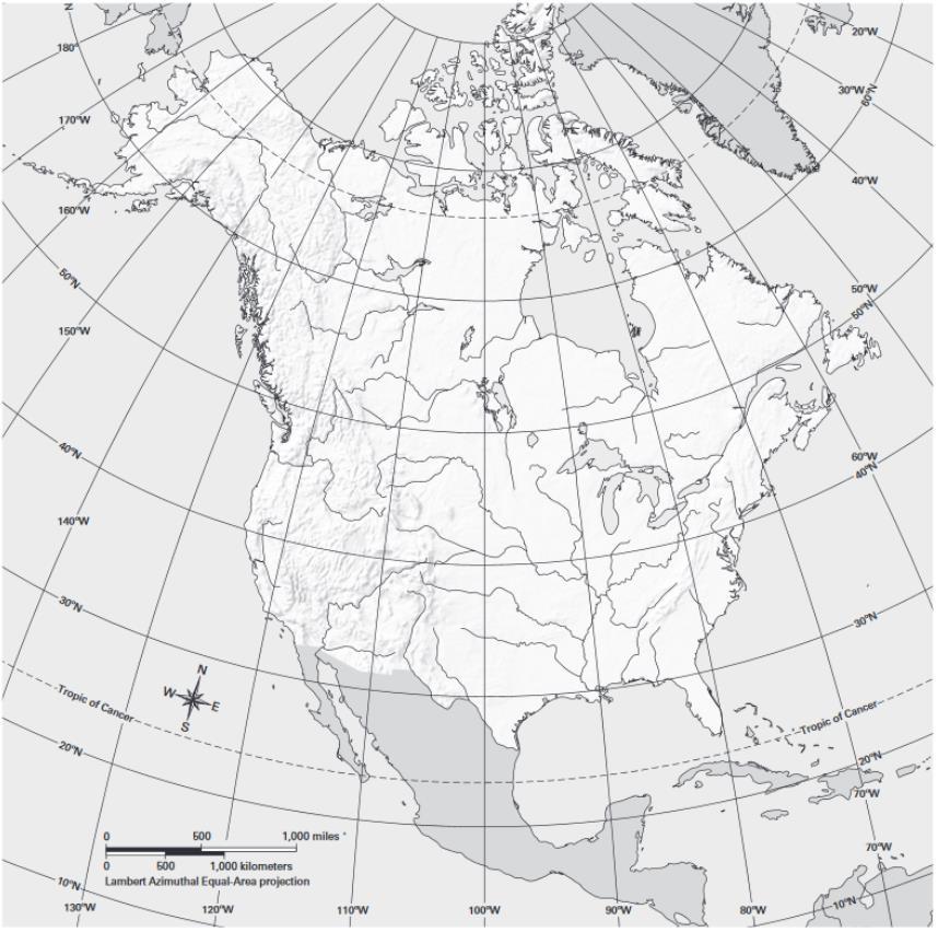
3 Unit 2: Canada and the United States Introduction Canada and the United States make up the region that covers most of North America. This region is bounded by the Atlantic Ocean on the east and the Pacific Ocean on the west. The Arctic Ocean lies to the north of this region. The Gulf of Mexico lies to the south. North America is the third largest continent in the world. This large region contains two sub-regions. Canada and Alaska make up the northern part. The 48 continental United States make up the southern part. West of the Great Lakes, the two sub-regions are separated by the 49th parallel of latitude. East of the Great Lakes, the St. Lawrence River separates the two sub-regions. Geoterms region: an area defined by one or more natural or cultural characteristics that set it apart from other areas Watch the video shown by your teacher. This video shows a physical feature of this region. What do you want to know about physical geography of Canada and the United States? Write some questions you have about physical geography in this region. As you read through the sections on the physical geography, come back here to add more questions. 3


4 Unit 2: Mapping Lab Physical Features If you look at a physical map of this region, you see mountains running along both sides, with a large, flat area in the center. This flat area runs from the Arctic Ocean to the Gulf of Mexico. It is made up of shield and plains. The term shield refers to the large core of very old rock that lies at the base of each continent. In North America, this rock core was exposed thousands of years ago. During the ice ages, glaciers scraped across the land, taking the soil with them. They left just a thin layer of soil in eastern and central Canada. Plains are flat or gently rolling areas of land. Much of the soil that glaciers scraped from the Canadian Shield ended up on the plains of Canada and the United States. Canada and Alaska The Canadian Shield covers almost half of Canada. The rest of this sub-region contains islands, lakes, plains, and mountains. The glaciers that scraped the shield also dug the huge holes that became the Great Lakes. These lakes lie between Canada and the United States. They are the world's largest group of freshwater lakes. The St. Lawrence River connects the Great Lakes to the ocean. To the far north are many smaller lakes and Hudson Bay. The region extends past the Arctic Circle and ends with a scattering of islands. The largest is named Baffin Island. In the Atlantic Ocean, off the southeast coast of Newfoundland, lie the Grand Banks. The ocean is very shallow here. Far to the west, in the Alaska Range, is the highest peak in North America. Mount McKinley rises 20,320 feet above sea level. Continental United States Two major mountain ranges run through the continental United States. In the east, the Appalachians are a gentle range of rounded peaks and deep valleys. In the west, the Rocky Mountains jut up into jagged, snowcapped peaks. The Rockies reach all the way from Alaska to New Mexico. Between these two ranges, wide plains stretch across the middle of the continent. This vast, mostly flat region extends about 2,500 miles north and south. From the Rockies, the dry and treeless Great Plains slope down to the central lowlands. 4

5 A large system of rivers drains most of the plains between the Rocky Mountains and the Appalachians. These rivers all flow into the muddy Mississippi River. The Mississippi empties into the Gulf of Mexico. Geoterms shield: the large core of very old rock that lies at the base of each continent glacier: a large mass of ice found near Earth s poles (continental glacier) or in a high, cold mountain valley (alpine glacier) freshwater: made up of water that is fresh, not salty; also describes creatures that live in fresh water, such as freshwater fish After you read the section on physical geography. Get a Physical Features map from your teacher. Find two or more sentences in the reading with information represented in the map and write them below. Be prepared to share what you found with the class. 5

6 Climate Climate varies widely across this large region, which reaches from the chilly Arctic to the warm waters of the Gulf of Mexico. Mount Washington in New Hampshire has been called Home of the World s Worst Weather. The fastest recorded wind speed ever, 231 mph, was recorded there in The northern parts of this landmass fall in tundra and subarctic climate zones. In subarctic climates, winters are very long, cold, and snowy. Summers are very short. They may be cool and rainy. The tundra climate zone is even more severe. Here, it is cold all year, even in summer. Winter temperatures are usually well below 0 F. In summer, the high temperatures may not be far above freezing (32 F). Areas with tundra climate get very little rain or snow. Beneath the surface, the ground is always frozen. These colder climates occur in places that don't get a lot of direct sunlight. The sun's rays are most direct at the equator. In general, the farther a region is from the equator, the colder the climate will be. Since the northern part of this region is very far from the equator, it is very cold. Canada and Alaska Most of Canada and Alaska have either a tundra or a subarctic climate. But the climate warms up as you move farther south. The area closest to the continental United States enjoys a mostly humid continental climate. Winters are still freezing cold, but summers can be hot and steamy. Nearly all of Canada and Alaska have heavy snows in the winter. But on the west coast of British Columbia, the marine west coast climate brings more rain than snow. There, and in the southern part of Canada, summers are warmer and drier. Continental United States No part of the continental United States has a tundra or subarctic climate. The climate here can vary greatly, depending on where you are. One state, California, has as many as five different climate zones. The southern part of the United States is generally warm year-round. The Southeast has a humid subtropical climate, influenced by the Gulf of Mexico. Hot, rainy summers follow mild winters that see some rain. The climate of Florida's southern tip is tropical wet and dry. There, it is hot all year, with both rainy and dry seasons. Arid and semiarid climates are common in the Southwest. This area is hot and dry in the summer and pleasant in the winter, with very little rain. Many older people from colder climates choose to retire in the Southwest. 6
7 The rest of the western United States has a variety of climates. The Sierra Nevada and Rocky mountains have a highlands climate. Along the northern Pacific Coast, a marine west coast climate brings mild winters and lots of rain. Most of the Midwest and Northeast have a humid continental climate. People here enjoy four distinct seasons. Summers are quite warm and winters are cold, often with snow and ice storms. Geoterms tundra: a climate zone with very cold winters, cold summers, and little rain or snow; a vast, treeless plain in the arctic regions between the ice cap and the tree line; also a vegetation zone that is a treeless plain with grasses, mosses, and scrubs adapted to a cold climate subarctic: climate or climate zone with cold, snowy winters and cool, rainy summers humid continental: a climate or climate zone with warm, rainy summers and cool, snowy winters marine west coast: a climate or climate zone with warm summers, cool winters, and rainfall all year humid subtropical: a climate or climate zone with hot, rainy summers and mild winters with some rain tropical wet and dry: a climate or climate zone that is hot all year with rainy and dry seasons Arid: dry or lacking rainfall; also a climate or climate zone that is hot and dry all year with very little rain semiarid: dry, with little rainfall; also a climate or climate zone with hot, dry summers and cool, dry winters highlands: a mountainous part of a country; a climate zone where temperature and precipitation vary with latitude and elevation; a vegetation zone where the mix of plants varies with latitude and elevation; also refers to the type of vegetation in this zone After you read the section on climate. Get a Climate Zones map from your teacher. Find two or more sentences in the reading with information represented in the map and write them below. Be prepared to share what you found with the class. 7


8 Vegetation Just as the climate varies across Canada and the United States, so does the vegetation. One widespread vegetation zone in this region is temperate grassland. Mainly short and tall grasses grow in temperate grasslands. Few trees grow in this zone because there is not enough rain. The Great Plains area of the United States and Canada is one of the world's largest temperate grasslands. This area combines a long growing season with fertile soil. As a result, the Great Plains provide very productive farmland. Another special vegetation zone in this region is tundra. This vegetation zone shares a name with the tundra climate zone, where it is cold year-round. The tundra vegetation zone is like a very cold desert. Few large plants can grow here. Like temperate grasslands, the tundra is treeless. Because the ground is frozen, trees cannot send their roots down into the soil. Only very low grasses, mosses, and scrub cover the ground during the short summer. They provide food for the grazing animals that live on the tundra. Coniferous forests, like this one in Acadia National Park, can be found throughout Canada and the United States. Canada and Alaska The tundra spreads across the far northern islands and coasts of Canada. Much of Alaska's land is tundra as well. In the ice cap on Alaska's highest peaks and glaciers, no plant life grows at all. Most of Canada and the rest of Alaska are covered in coniferous forests, filled with trees such as cedar, fir, pine, and spruce. The needle-like leaves of these trees stay green all year. The warmer climate in southeastern Canada supports mixed forest. Here you find a mix of both coniferous and deciduous trees. Deciduous trees, such as oak, elm, and birch, have broad leaves that they shed each fall. The southcentral part of Canada is temperate grassland. Continental United States The vegetation of the continental United States ranges from tropical palms to desert sagebrush. There are thick pine forests in the West, grasses on the central plains, and forested swamps in the South. Spreading up and down the East Coast are forests of all types coniferous, deciduous, and mixed. The extreme Southeast along the Gulf Coast and in Florida's Everglades is home to tropical grasslands. The tough saw-grass and scattered trees in the Everglades are adapted to the tropical wet and dry climate. Across the central part of the United States is a wide band of temperate grassland. This area was once thick with prairie grasses. However, much of the land has been plowed for farming. It is now covered with fields of corn, wheat, and other crops. 8
9 In the West, coniferous forests blanket the mountains. Desert scrub grows throughout the deserts and canyons of the Southwest and Great Basin. Along the California coast, chaparral dots the Coast Ranges. Geoterms vegetation zone: a large area of Earth with a certain mix of plants and trees that are adapted to similar conditions temperate grassland: vegetation or a vegetation zone of mainly grasses and scattered trees adapted to a tropical wet and dry climate desert: a geographic region with too little rainfall to support much plant life; also a vegetation zone ice cap: a climate or climate zone that is very cold all year with permanent ice and snow; also a permanent, domeshaped covering of ice over a large area; also a vegetation zone that is too cold to support plant life coniferous forests: a vegetation zone of mainly evergreen trees with needles and cones; also refers to the type of vegetation in this zone mixed forest: a type of vegetation or vegetation zone that includes both coniferous and deciduous trees tropical grasslands: vegetation or a vegetation zone of mainly grasses and scattered trees adapted to a tropical wet and dry climate Desert scrub: a vegetation zone of mainly small trees, bushes, and other plants adapted to a dry climate; also refers to the type of vegetation in this zone chaparral: a vegetation zone of mainly small trees and bushes adapted to a Mediterranean climate; also refers to the type of vegetation in this zone After you read the section on vegetation zones. Get a Vegetation Zones map from your teacher. Find two or more sentences in the reading with information represented in the map and write them below. Be prepared to share what you found with the class. 9

10 10

11 Human Geography All of the other regions of the world are made up of many countries. However, this region is made up of just two large countries: Canada and the United States. In land area, Canada is the second largest country in the world. Yet its population is quite small for its size. The United States is almost as large as Canada in land area. But the U.S. population is nine times the size of Canada's. The two countries share a common cultural background. Most of the people are English-speaking, although Canada officially uses French as well. Both countries have native populations. Both countries were colonized by settlers from Europe about 500 years ago. In later years, immigration from all parts of the world has enriched the two countries with a wide variety of cultures. Watch the video shown by your teacher. This video shows an example of human activity in this region. What do you want to know about human geography of Canada and the United States? Write some questions you have about physical geography in this region. As you read through the sections on the physical geography, come back here to add more questions. 11


12 History The histories of Canada and the United States reveal why these countries are so similar. Early Times Scholars believe that North American history began when bands of hunters migrated to Alaska from Asia. This happened more than 10,000 years ago. Over time, these first bands settled throughout the region. As they adapted to their environment, each group developed its own culture. The Inuit, or Eskimo, people stayed in the far north. They hunted Arctic animals for food and clothing. Other groups settled along the west coast of the continent. Fish and trees were plentiful there and provided food, clothing, and shelter. Many groups settled in the central and eastern parts of the region. A group called the Anasazi built cliff Anasazi houses in the southwestern United States. The Colonial Period Europeans began coming to North America in the 1500s. The French and British set up colonies along the eastern coast. The Spanish colonized Florida, Texas, and California. The American colonies revolted against Britain in 1775, and a successful war for independence followed. In 1783, the United States became an independent country. Yet there was not freedom for everyone. Millions of slaves lived in the United States. The country split over the question of slavery, and it fought a civil war between 1861 and In 1865, slavery ended in the United States. The Declaration of Independence, which explained why the 13 colonies wanted to be free of British rule and also detailed the importance of individual rights and freedoms, was adopted on July 4, Canada was first colonized by the French. After a war, France turned Canada over to Great Britain in French culture still remains strong in Canada. Many Canadians speak French as their first language. In 1867, Canadians won the right to govern themselves. Yet Canada still was part of the British Empire. The Modern Era In the twentieth century, Canada and the United States formed a strong bond. Canada gained its independence from Great Britain in People on both sides of the U.S. Canadian border welcomed this event. In 1939, war broke out in Europe. War was also raging in Asia. This global conflict is known as World War II. The United States and Canada worked closely together to end this war. Since then, they have continued to work together for world peace. Today Canada and the United States are closely linked by trade. Canadians buy many products that are made or grown in the United States. Americans also buy many Canadian products. In 1994, the North American Free Trade Agreement (NAFTA) took effect. NAFTA made trade between the two countries easier. Though concerns have grown over the effects of NAFTA, Canada and the United States still plan to work closely together. 12

13 After you read the section on history. Find two or more sentences in the reading with information represented on the timeline and write them below. Be prepared to share what you found with the class. 13


14 Population More than 360 million people altogether live in Canada and the United States. This is about 5 percent of the world s population. The population of this region is growing very slowly compared with other parts of the world. Some parts of this region are almost empty. The western deserts are too dry, and the far north is too cold for settlement. Very few people live in these places. Northern Canada is thinly settled, with a population density as low as one person per 25 square miles. Most Canadians live close to the U.S. border. Toronto is the largest urban area in Canada. Throughout the region, people tend to cluster in or near cities, where more jobs can be found. Most people in Canada and the United States are Christian. Almost one fourth of these are Roman Catholics. Islam is the fastest growing religion here. Other faiths include Judaism, Buddhism, and Hinduism. About 1 out of 5 people have no religion. What kinds of jobs do you think people in urban areas might have in the United States? What kinds of jobs do you think people in rural areas might have in the United States? 14

15 How do you think population growth will change your neighborhood by 2050? After you read the section on population. Find two or more sentences in the reading with information represented on the Population Density map and write them below. Be prepared to share what you found with the class. 15


16 Economic Activity Canada and the United States are rich in many kinds of resources. One of these is good farmland. As a result, commercial farming is an important economic activity in this region. Commercial farming is the growing of farm products for sale to others. Wheat, for example, is a commercial crop. It is grown widely in the U.S. Midwest and in the prairie provinces of Canada Alberta, Manitoba, and Saskatchewan. The farmers of this region sell their crops around the world. They produce about half of the world s grain exports. From California and Florida, farmers ship fruits and vegetables. They help make this region the world s leading food exporter. Cold winters have little impact on oil fields in Alberta, Canada. Oil is pumped all year, regardless of the season. Forestry is also important to this region. Forestry is the planting, growing, and harvesting of trees. North America was once covered with thick forests. Over time, many trees were cut down for fuel and lumber. In southern Canada and in several corners of the United States, logging is still a big industry. Resources Canada and the United States also have a wealth of mineral resources. Oil and coal, used for energy, are the most important. Texas, Alaska, and Alberta have thriving oil industries. Coal is plentiful in the Appalachian and Rocky mountains. It is also mined in the river valleys of the central United States. Mines in Quebec, Ontario, and British Columbia produce gold, nickel, and copper. In the western United States, New Mexico has large reserves of uranium. Arizona is rich in copper deposits. Land Use Much of this region is used for raising livestock. Cattle graze widely across the western range. Sheep ranches are also common. Trade and manufacturing are strong in the urban centers of this region. In the United States, manufacturing plays an especially big role in the Midwest and Northeast. Factories there produce cars, steel, plastics, glass, and textiles. Orange groves need lots of sunshine and frostfree winters. Oranges are an important crop in Florida and California 16
17 Geoterms economic activity: any action that relates to the making, buying, and selling of goods and services Commercial farming the growing of farm products for sale to others. Forestry: the planting, growing, and harvesting of trees Think about the economic activity you have seen in your community. Give one example each of making, buying and selling goods and services. After you read the section on economic activity. Find two or more sentences in the reading with information represented on the Economic Activity map and write them below. Be prepared to share what you found with the class. 17

18 18

19 Question 1. What is the largest area in Canada and the United States that is densely populated (over 250 people per square mile)? What are four cities in that area? Answer Map Used: 2. In which state in the United States can you find all of the following climates: arid, semiarid, Mediterranean, highlands, and marine west coast? Map Used: 3. Which resource is most abundant in Texas, Alaska, and Alberta? Which state or province appears to have the most of that resource? Map Used: 4. Which four territories and states have both a subarctic and a tundra climate and include land that is both north and south of the Arctic Circle? Map Used: 5. What is the most common type of vegetation in the central area of southern Canada and the United States? Which country has more land with that type of vegetation? Map Used: 19
20 6. What types of land use occur along both the Pacific Coast and the Atlantic Coast of Canada and the United States? Map Used: 7. Which five lakes together make up the largest body of fresh water in Canada and the United States? Map Used: 8. California is the most populated state in this region. Nunavut is the least populated. How do climate and economic activity help explain why this is the case? Map Used: 9. Name three states, provinces, or territories that produce more hydroelectric power than other places in the region. What physical feature in these places might help explain why hydroelectric power is a resource there? 20 Map Used: 10. A farmer grows sugarcane, a crop that does well only in a humid subtropical climate with other tropical grassland vegetation. In his free time, he loves to go sailing on the ocean year-round. His farm is near a densely populated city that lies on a very large river. Where does the farmer live? Why do you think so? Map Used:

21 21
22 22
23 Where Are You! Game We think the field photograph best matches Location. Supporting-evidence statements: 1. From the map, we learned that this location In the field photograph, we see 2. From the map, we learned that this location In the field photograph, we see 3. From the map, we learned that this location In the field photograph, we see 23

24 24

25 Unit 2: Lesson 7 Consumption Patterns in the United States: The Impact of Living Well Introduction Americans are eager consumers who buy and use a lot of goods and services. Shopping centers in the United States offer consumers a huge variety of products, and supermarkets are filled with foods for every taste. Stores large and small begin selling holiday merchandise months in advance to encourage shoppers to buy more. Car dealers tempt buyers with row upon row of shiny vehicles. Meanwhile, the Internet has turned the home computer into a virtual shopping mall. Americans have made consumption a way of life. Consumption means the using up of goods or services. Some goods, like food, can be consumed only once, whereas others, like clothing, can be used again and again until they are worn out or go out of style. The average American spends tens of thousands of dollars each year on personal consumption. These purchases include spending on everything from food and clothes to gas and housing. This amount is typical for people living in developed countries, which are wealthy countries like the United States and Canada. However, it is more than most people earn in a year in developing countries, such as Mexico and India. Shoppers line up before dawn for a sale. In this lesson, you will read about consumption patterns in the United States. You will discover how they compare with those of other countries, both developed and developing. And you will read about the impact of American consumption on the resources and environment of the planet. 7.1 The Geographic Setting In 2017, the United States had a population of more than 325 million people, which made it the third most populous country in the world. In terms of population, the United States was still much smaller than the two largest countries, China and India, each of which had a population of more than 1 billion people. Despite having fewer people, the United States consumed far more than did either China or India. This difference was the result of many factors. The most important factor, however, was the countries different levels of development. Levels of Development This bar graph compares per capita GDP of six countries. Per capita GDP is the value of goods and services produced per person in a country in a year. Developed countries have a high per capita GDP. People in those countries have more money to spend on consumer goods and can therefore consume more. Consumption Depends on Levels of Development The United States is one of the world s developed, or wealthy, countries. Today, there are more than 50 developed countries around the world.most countries in Europe belong to this group, as do Canada, South Korea, Japan, Australia, and New Zealand. 25

26 People in developed countries live well compared to most of the world. Most people in developed countries live in urban areas and work in factories or offices. Their governments provide them with many benefits, which include public schools, fire protection, and safe drinking water. Most workers in developed countries earn good wages and can afford to consume a lot of goods and services. In contrast, there are more than 130 developing nations in the world today. These are countries that are still building their economies by improving agriculture, developing industries, and increasing trade. This group includes most of the countries in Asia, Africa, and Latin America. Many of these countries have too few industries to provide good jobs for their people, and many also lack a strong and stable government. People in developing countries are more likely to live in rural areas and work on farms. Their governments provide them with only limited benefits. They may not have access to good schools or safe drinking water. Most of these people earn low wages, and as a result, their consumption may be quite limited, their homes modest, and their possessions few. Per Capita GDP Is One Measure of Development There are many ways to measure a country s level of development. One method of evaluation is to look at how many years of schooling people in the country have. Another gauge of development is to look at average longevity, or how long its people live. The most common measure of development is based on a country s gross domestic product, or GDP. which is the total value of goods and services that a country produces in a year. Goods are things that are produced for sale or use, such as food, clothing, and cars. Services are tasks done by some people for other people, such as teaching or repairing a car or a computer. A country s level of development depends on its per capita GDP. Per capita means per person. Per capita GDP is calculated by dividing a country s total GDP by its population. The result, which is the average production for one person, serves as a rough measure of how rich or poor a country is. The United States has a high per capita GDP, meaning that it is a wealthy country. This wealth strongly influences how much Americans consume year by year. 26


27 Geoterms consumption the using up of goods and services. This term is also used to describe the purchase and use of goods and services by consumers. developed country a wealthy country with an advanced economy. Developed countries have many industries and provide a comfortable way of life for most of their people. developing country a poorer country with a less advanced economy. In general, developing countries are trying to increase their industries and improve life for their people. gross domestic product (GDP) the total value of goods and services produced in a country in a year per capita by or for each person. A per capita figure is calculated by dividing the total amount of something by the number of people in a place. Which of the following statements is NOT true? 27
28 consumption Symbol: Definition: Sentence developed country Symbol: Definition: Sentence developing country Symbol: Definition: Sentence gross domestic product (GDP) Symbol: Definition: Sentence per capita Symbol: Definition: Sentence 28

29 7.2 Food Consumption Patterns In the developed world, most people can go to the grocery store and get nearly any food they need or even want. People in the developing world may not have this luxury. Food distribution and consumption patterns in these countries differ from those in the developed world. Although supermarkets do exist in the developing world, they are primarily in urban areas. And while they have made food more affordable for poor consumers, cost remains an issue for many. In rural areas where access to stores is limited, many continue to depend on food that they grow themselves. More Than Enough Food Enough for All, But Some Go Hungry. There is enough food on the planet to feed everyone, but it is not distributed evenly. Much of the food stays in the developed world, where people consume more calories per day than people in the developing world. Calories are a measure of the amount of energy in food. On average, adults need about 2,300 calories per day to live healthy lives. The average person in many developed countries consumes an average of around 3,300 calories a day. This intake is more than enough food to meet one person s nutritional needs. Meanwhile, many people in the developing world do not get enough to eat. In some poorer countries, average consumption per person is less than 2,300 calories a day. In sub-saharan Africa, more than 20 percent of the population goes to bed hungry each night. Poverty Leads to Hunger As you have read, hunger is not caused by a worldwide shortage of food. The developed world produces more food than it can consume, and likewise, many developing countries produce enough food to feed their people. However, poor people in both rich and poor countries may not earn enough money to buy that food. Poverty denies them access to adequate nutrition. India, for example, has the largest number of people living in poverty in the world, and it also has the largest number of hungry people. Farmers in India produce enough food to feed the entire population, but many of them export their crops to other countries. When they sell their crops abroad, they get higher prices for them than they would at home, which is good for Indian farmers. However, higher crop prices may mean that many other poor Indians have less to eat. Indicate if each statement is true or false. Geoterms calories: a measure of the amount of energy in food People in rich countries consume fewer calories per day that people in the developing world. The world does not produce enough food to feed everyone. In some of the poorer countries, average consumption per person is about 2,400 calories a day India has the largest number of hungry people in the world. Farmers in India produce enough food to feed the entire population, but many of them export their crops to other countries. 29

30 30

31 Section 2 - Food Consumption Patterns Analyze the food consumption cartogram with your class. Then, with your group, read Section 2 and answer the questions below. How many calories per day does the average person need to live a healthy life? List three countries that consume a high number of calories per capita, per day. What type of country tends to consume more calories per capita? Why do you think that is? List three countries that consume a low number of calories per capita, per day. What type of country tends to consume fewer calories per capita? Why do you think that is? 31
32 Your teacher will assign your group one of the following roles: (circle one) developed country developing country Using information from the CIA's World Factbook and Section 1, The Geographic Setting, in the Student Text, select a specific country for your group to represent. Country your group selected: 32


33 7.3 Oil Consumption Patterns Picture morning rush hour, when the streets are filled with gas-guzzling cars, motorcycles, and buses. This was once an image that was unique to the developed world. However, much of the developing world increasingly faces the same challenges related to transportation, such as costs, traffic, pollution, and, especially, the use of gasoline. Oil, or petroleum, consumption follows a pattern similar to food consumption. Developed countries use more oil than most developing countries. Oil is a fossil fuel that has many uses. It is refined into gasoline and used to make asphalt to cover roads. Petroleum is also used to make plastics, nylon, and other products. Oil Fuels the Developed World Developed countries depend on oil to meet most of their energy needs. Their cars, trains, and planes burn fuels made from oil, and they use oil to heat buildings in the winter. Some power plants burn oil to generate electricity. The United States leads the world in oil consumption. Americans make up just over 4 percent of the world population, but they consume 20 percent of the oil pumped out of the ground each year. Most of the oil Americans consume is burned as gasoline. Oil Use in the Developing World Is Growing As the economies of countries in the developing world grow, more of their people can afford luxuries like cars. As a result, oil consumption is rising in many developing countries. China is a good example. In 1990, there were slightly more than 5 million cars in China; 10 years later, China had more than 16 million cars. By 2017, that number reached 200 million. To keep all those cars running, China needs far more oil than it did in the past. At present, there is enough oil to meet world demand, but oil will run out someday. Some experts expect oil production to peak in the mid- 21st century, after which it will begin to decline, whereas others believe this peak could occur sooner. Some experts now believe that the demand for oil will decline before production begins to decline as people turn to other energy sources. For example, by 2025, China wants one-fifth of all new cars to run on alternative energy sources, such as electricity. Goods Made from Oil Oil is the main ingredient in most goods made of plastic, nylon, or vinyl. Geoterms fossil fuel: any fuel, such as petroleum, coal, and natural gas, that is made from the remains of prehistoric plants and animals 33

34 Section 3 - Oil Consumption Patterns Analyze the oil consumption cartogram with your class. Then, with your group, read Section 3 and answer the questions below. What is oil used for? Which developed countries consume the most oil per capita? Why do you think that is? Which developing countries consume the most oil per capita? Why do you think that is? 34
35 Switch roles for this round. If you were a developed country choose a developing country. If you were a developing country choose a developed country: (circle one) developed country developing country Using information from the CIA's World Factbook and Section 1, The Geographic Setting, in the Student Text, select a specific country for your group to represent. Country your group selected: 35

36 7.4 Computer and Internet Use Patterns Walk into almost any school in the United States today, and you will see students and teachers using computers. Walk into a school in a poor village in India, and you may not see a single computer. In fact, you may not even see a light bulb. Around 37 percent of schools do not have electricity, and those that do may experience power cuts. Developed and developing countries differ in their access to technology. Technology is the creation and use of tools to meet practical needs. Most people in poor countries are limited to cheap and simple technologies such as water pumps and irrigation systems. People in wealthy countries have greater access to advanced technologies such as computers, mobile devices like smartphones and tablets, and the Internet. Computers Are Everywhere in the Developed World It is hard to imagine life in developed countries without computers, mobile devices, and the Internet. Governments and businesses depend on computers to store and manage information and to reach members of the public. Families use the Internet to stay in touch with relatives, buy goods, share photographs, and read news updates. Computers and the Internet were invented in the United States, and most Americans have access to this technology. By 2017, about 88 percent of American adults reported using a computer and the Internet, and the majority of U.S. households owned a computer and a mobile device. Developing Countries Face a Digital Divide Access to computers is more limited in the developing world. By 2017, only 53 percent of Chinese people used the Internet, and in India, only 34 percent did. These figures are lower in many other developing countries. The gap between people with access to computers, mobile devices, and the Internet and those without is called the digital divide. Without a computer or mobile device and Internet access, it is more difficult to participate in the modern economy and climb out of poverty. Many poor countries, such as India, are working to reduce this divide. Today, thousands of institutes of higher education in India offer computer classes and degrees to students. India is also bringing Internet access to thousands of schools across the country. Geoterms technology: the creation and use of tools to meet practical needs; also refers to the tools themselves digital divide: the difference in opportunities available to people who have access to computers and the Internet and those who do not 36
37 Indicate if each statement is true or false. In 2008 more Americans than Chinese had access to the internet. Developed countries have access to more advanced technology. Access to computers is more limited in developed countries. By 2008 almost 50% of American adults used a computer. Poorer countries are working to reduce the digital divide in their countries. 37

38 7.4 Computer and Internet Use Patterns Read Section 4, Computer and Internet Use Patterns, in the Student Text. Complete the corresponding section in your notebook with your group. What are computers and the Internet used for? Which countries have the most access to technology? Why do you think that is? Which countries have the least access to technology? Why do you think that is? 38
39 Switch roles for this round. If you were a developed country choose a developing country. If you were a developing country choose a developed country: (circle one) developed country developing country Using information from the CIA's World Factbook and Section 1, The Geographic Setting, in the Student Text, select a specific country for your group to represent. Country your group selected: 39

40 7.5 The World s Greatest Producers You have read that the United States consumes more goods and services than many other countries but it also produces more. The GDP of the United States is greater than that of China and India combined. Several factors contribute to this high GDP, including abundant natural resources and advanced technologies. However, the greatest source of wealth for any country is its people. An Educated Workforce The United States has a highly skilled workforce. It was one of the first countries to create a public education system. Today, most young people in the United States complete high school, and more than 65 percent of these graduates continue on to some form of higher education after high school. Many adults return to school during their lifetime to learn new skills. All of this schooling helps to make American workers among the most productive in the world. Worker productivity is measured by the value created per hour of work. A Strong Work Ethic Education is not the only reason Americans are so productive. Another factor is the American work ethic, which is the belief in the moral value, or goodness, of hard work. Most Americans believe that working is good for people because it gives purpose to their lives and benefits families and communities. This strong work ethic is tied to another belief. Most Americans grow up believing that they can be successful in life. Many of them view success as making a lot of money, whereas others see success as having work they love to do. In either case, Americans believe that hard work produces success. Both the work ethic and the drive for success encourage Americans to work hard. On average, Americans work longer hours than workers in most developed countries, and they take less time off for vacation. All of this hard work helps Americans to produce more than workers elsewhere. And because Americans produce more, they have the money to consume more. Educated Americans In 1900, only about 1 in 10 Americans completed high school. Today, more than four-fifths of all students graduate from high school, and around three-fifths go on to graduate from college. These students graduated from Iowa State University, where the large graduation ceremonies are held in either the school s basketball arena or its football stadium. 40


41 41 Educated Americans In 1900, only about 1 in 10 Americans completed high school. Today, more than four-fifths of all students graduate from high school, and around three-fifths go on to graduate from college. These students graduated from Iowa State University, where the large graduation ceremonies are held in either the school s basketball arena or its football stadium.

42 Section 5 - The World s Greatest Producers Analyze the gross domestic product (GDP) cartogram with your class. Then, with your group, read Section 5 and answer the questions below. What three important factors contribute to the United States high GDP? How does education affect GDP in the United States? How does the American work ethic affect GDP? How do you think a country s GDP affects its citizens ability to consume? 42
43 Switch roles for this round. If you were a developed country choose a developing country. If you were a developing country choose a developed country: (circle one) developed country developing country Using information from the CIA's World Factbook and Section 1, The Geographic Setting, in the Student Text, select a specific country for your group to represent. Country your group selected: 43

44 44

45 45


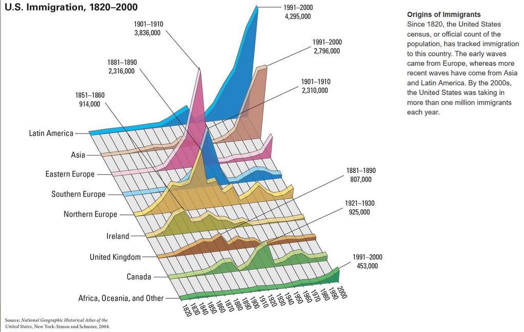
46 Unit 2: Lesson 7 Migration to the United States: The Impact on People and Places Introduction Signs appear in Korean and English in New York City s Koreatown. Has your family moved recently? If so, was the move a big change or a small change? Many families change their neighborhood when they move somewhere new, whereas others change their city or state. Some families even change the country in which they live. Making the decision to emigrate, or move away from one s home country, is never easy. Those who emigrate must leave behind family and friends, familiar places, and customs. However, millions of people around the world make this decision every year, and many come to the United States. Since the beginning of the country s history, the U.S. population has consisted of families who have come from other countries. When people immigrate, or move to a new country, they experience many changes. They leave familiar things behind and arrive in a place where most things are new to them. Often they need to learn a new language and how to make a living in a strange place. These changes can be difficult to adjust to initially. People also bring their culture and traditions with them. Their different ways can sometimes be hard for their new neighbors to adjust to. In this lesson, you will learn why people decide to emigrate from their home countries, and you will find out why people immigrate to the United States. You will also learn about the impact that different migration streams, or flows of immigrants, have had on this country. Additionally, you will see how migration affects the countries that people leave behind. Geoterms emigrate: to move from a country. People who leave a country are called emigrants. immigrate: to move to a country. People who move to another country are called immigrants. migration stream: constant flow of migrants from one country into another country. The largest migration stream into the United States today is from Mexico. 46

47 8.1 The Geographic Setting Both push factors and pull factors drive people to move to a new country. Push factors give people good reason to leave unpleasant circumstances in their home country, such as war and poverty, discrimination, and famine. Pull factors, such as freedom and opportunities for a better life, attract people to a new place and encourage them to immigrate there. Push and pull factors have helped to drive one of the most dramatic migrations in history. Since 1820, more than 82 million people have come to the United States. This enormous migration came in three great waves. Three Waves of Immigrants The first great wave of immigration started with the founding of the United States. These early immigrants came primarily from northern and western Europe, and many were escaping from poverty or hunger. Some settled in cities, and others found land to farm as the nation expanded westward. In the late 1800s, a second wave of immigrants started to arrive from eastern and southern Europe. Many were refugees escaping war or persecution because of their religious beliefs. Most found work in the growing cities of the United States and settled in neighborhoods with other immigrants from their home countries. A third great wave of immigration started in the late 1960s and continues today. In 1965, the United States changed its immigration laws, allowing many more newcomers to enter. Between 1970 and 2005, more than 28 million people moved to the United States, including a high percentage of people from Latin America and Asia. Many Asians found new homes on the West Coast. Most Mexican immigrants settled in the Southwest. Cubans flocked to Florida, and people from other Caribbean islands settled in New York City. Over time, these immigrants have moved to communities throughout the country and have both adjusted to and changed life in the United States. Geoterms push factor: something that encourages people to leave a place behind pull factor: something that encourages people to move to a new place discrimination: unfair treatment of a person or group based on class rather than individual worth famine: extreme and general scarcity of food, as in a country or a large geographical area. refugee: someone who seeks safety by going to another country. Refugees may be escaping political unrest or war. Or they may fear being attacked because of their beliefs. persecution: unfair treatment of others because of who they are or what they believe 47

48 48

49 Why have so many people immigrated to the United States since 1820? Write the correct answers onto the image. Create an illustrated dictionary of the Geoterms by completing these tasks: Write a definition of each term in your own words. Write a sentence that includes the term and the word person or people. emigrate Symbol: Definition: Sentence immigrate Symbol: Definition: Sentence 49
50 migration stream Symbol: Definition: Sentence pull factor Symbol: Definition: Sentence push factor Symbol: Definition: Sentence refugee Symbol: Definition: Sentence 50

51 8.2 What Push Factors Drive Emigration? One night in the late 1980s, John Deng James awoke to the sound of gunfire. The terrified child ran barefoot into the nearby woods, where he encountered other frightened children. They were too young to understand why their homeland, the African country of Sudan, was at war. Regardless, they recognized that they had to escape the horror, despite having no means of transportation. And so they started to walk. The Push Factor of War These refugees are fleeing a war in the country of Syria in Recent wars have caused millions of people to leave their homelands. Sometimes the refugees return home when the conflict ends, but often they stay in their new country. John Deng James is part of a group of political refugees known as the Lost Boys of Sudan. The Lost Boys, and other children who lost their parents in the war, walked for hundreds of miles in search of a safe place. Many died along the way of hunger and thirst. Those who survived eventually reached a refugee camp in the neighboring country of Kenya. The survivors were among the countless people around the world who have been pushed to emigrate because of war, violence, or genocide, an organized elimination of a national, political, racial, or ethnic group. Political Push Factors War is one of many political factors that can create refugees. Political refugees may flee a country because they fear its leaders. Or they may fear persecution, the unfair treatment of people because of who they are or what they believe. These political push factors have one thing in common: they involve the way a government treats its people. People are unlikely to flee a government that treats its citizens fairly, but a government that rules through fear is likely to create discontent among its people. Many of these people may become political refugees. Many Cuban immigrants have come to the United States as political refugees. Cuba is an island in the Caribbean Sea, south of Florida. In 1959, a leader named Fidel Castro took over Cuba s government and quickly made himself a dictator. Cubans who spoke out against Castro or the way he governed Cuba risked being jailed. Faced with that threat, thousands of Cubans fled to the United States. Although Castro died in 2016 and the Cuban people have been granted more rights in recent years, Cubans continue to flee to the United States. Environmental Push Factors Changes in the environment, such as a long-term drought, can push people to emigrate. In the 1840s, a devastating plant disease struck Ireland. A fungus destroyed Ireland s most important crop, the potato, which had been the main food of the Irish. Without enough potatoes, people faced starvation. In response to this crisis, 1.5 million people left Ireland, including many Irish emigrants who came to the United States. Other environmental changes result from human activity. In 1986, an explosion rocked the Chernobyl nuclear power plant in what is now Ukraine. This accident left a large area of poisoned soil, air, and water around the power plant. Tens of thousands of people were forced to evacuate their homes and move to safer areas. You will read more about the Chernobyl accident in Lesson

52 Economic Push Factors The most common push factors are economic. Most of the early immigrants to the United States were impoverished farmers or working people. They saw no way to improve their lives in Europe, so they decided to try their luck in a new country. In the United States, they found many kinds of economic opportunities. These same economic push factors remain at work today. Many people around the world want a better future than they believe exists in their homeland. Some of them will seek that future in another country, and often that country is the United States. Geoterms genocide: the elimination of a group of people based on race, religion, or some other factor drought: an unusually long period in which little or no rain falls 52


53 8.3 What Pull Factors Draw Immigration? In 2001, some of the Lost Boys of Sudan started another long journey one that took them from a refugee camp in Africa to a new life in the United States. They arrived in the city of Boston, Massachusetts, in the middle of winter. I was wearing very light clothes, and we d never seen snow before, recalled John Deng James. When we went outside, we couldn t feel our hands and our ears. Like many refugees, the Sudanese teenagers looked forward to feeling safe, going to school, and getting jobs. These are just some of the pull factors that attract immigrants to the United States. Family Pull Factors Another powerful pull factor is the desire to unite divided families. Often young men are the first family members to immigrate to another country. Once they find jobs and somewhere to live, they send for their wives, children, and parents. Between 1965 and 1975, of the more than 142,000 Greeks who came to the United States, almost all of them were joining relatives who were already living here. Education Pull Factors Education is a strong pull factor in immigration. Many families migrate so that their children can attend good schools. Approximately 15 percent of students in this country s schools were born in another country. The Pull of Education U.S. colleges and universities attract over 1 million students each year. These students at Columbia University are holding their national flags during their graduation ceremony. Older students come to attend colleges and universities. In the school year, more than 1 million foreign students were enrolled in U.S. colleges and universities. Many of these students will later decide to make the United States their permanent home. Quality-of-Life Pull Factors Most people, however, move hoping to improve the quality of their lives. In the United States, this hope is called the American Dream. This is the belief that people here can create better lives for themselves and their children, thanks to the economic opportunity and political freedom this nation enjoys. For many refugees, a better life begins with a sense of safety. For much of their history, Jews have been persecuted for their religious beliefs, but in the United States, Jewish immigrants found freedom to worship without fear. Migrant Farm Labor Immigrants can often find work as farm laborers or in other agricultural fields. In the United States, around 70% of crop workers on farms are foreign born. For other immigrants, a better life usually starts with a better job. Even lowwage jobs in the United States usually pay more than most immigrants could earn in their home countries. With more money, immigrant families can afford better food, housing, and health care. They can also save up to bring other relatives to this country. 53
54 Which of the following are NOT common pull factors? A. family pull factors B. quality-of-life pull factors C. educational pull factors D. political pull factors 54

55 8.4 How Does Immigration Affect the U.S.? For John Deng James and other Lost Boys, adjusting to life in a new country was difficult. Initially, they were terribly homesick. Moreover, they were hungry. They did not know how to shop for food in supermarkets, nor did they know how to cook because they had never seen a stove or a microwave before. They had never even used a telephone. Like millions of other immigrants, the Sudanese refugees adapted to their new environment. Within six months, James had two jobs and was studying for college, changes which affected how he thought about life. In the United States, you determine who you are, he told a reporter. Now I have a vision of my future. I can go to school, I can work, and I can do what I want. At the same time, he and the other Lost Boys were beginning to have an impact on their adopted country. Immigrants in the Workforce Today, about 17 percent of all workers in the United States are immigrants. Some hold low-paying jobs as farmworkers or household help, whereas others hold well-paid jobs as doctors, nurses, and engineers. Economic Impacts: Jobs The United States has long depended on immigrants for labor. Early immigrants cleared large tracts of forests for farms. Later immigrants built roads and railroads across the continent, filled jobs in mines and factories, and even helped fight this country s wars. Immigrants required no special skills to perform these types of work. All they needed was their determination to succeed in their new land, and they became important builders of the nation. Some of the immigrants entering the United States today arrive with few skills. As a result, they are often limited to low-paying jobs. Some work as farm laborers, planting and harvesting crops on large farms, whereas others find jobs as cab drivers, house cleaners, restaurant workers, or nannies. The work that these immigrants do helps to keep the economy of the United States going. Not all immigrants take low-paying jobs. Some newcomers are highly educated and skilled, and contribute to the economy in many ways. They work as doctors, professors, and computer programmers. Others establish new businesses, and some become famous athletes, musicians, or artists. Those who succeed create jobs for immigrants and native-born workers alike. Some native-born Americans resent having to compete with immigrants for work and complain that immigrants are taking our jobs. However, the reality is that immigrants are frequently employed in jobs that native-born workers are not eager to fill. Economic Impacts: Taxes Like native-born workers, immigrants who work pay taxes. Their taxes help support public services that are important to both immigrants and native-born Americans, such as public schools, libraries, and health clinics. At the same time, many immigrants also require services that are paid for with tax money. For example, immigrants who do not speak English may need language classes. As with native-born Americans, those who cannot work may need public assistance or free health care. 55 Immigrants in the Workforce Today, about 17 percent of all workers in the United States are immigrants. Some hold low-paying jobs as farmworkers or household help, whereas others hold well-paid jobs as doctors, nurses, and engineers.

56 In states with many immigrants, such as California and Texas, providing such welfare services is expensive. Some taxpayers resent these costs, whereas others believe the benefits that immigrants bring to their state outweigh the cost to taxpayers. Cultural Impacts: Neighborhoods, Foods, and Holidays Immigrants create cultural as well as economic change. They introduce Americans to different ways of life from around the world. This process of spreading cultural features from one place to another is called diffusion. Although a mixing of cultures occasionally leads to conflict, it can also make life more varied and interesting. Newcomers to the United States often live close to other people from their homeland. These immigrant neighborhoods sometimes have names like Chinatown or Little Italy. Here immigrants can speak their native language, find familiar foods and eat in restaurants that serve dishes they grew up eating, and hear news from their homeland. Such immigrant neighborhoods have made American cities more exciting places as immigrants share their languages, foods, and customs with native-born residents. Chinese New Year Celebration The dragon dance is a colorful part of Chinese New Year celebrations. Once such events were limited to immigrant communities. Today, they are enjoyed by Americans from many backgrounds. Immigrants bring new foods to the United States. Some of these foods, such as potstickers, sushi, bagels, and tacos, have become very popular. They are so commonplace that they seem almost as American as apple pie. Immigrants have introduced new holidays to American life. Today, people from many different backgrounds in cities all over the United States enjoy celebrating St. Patrick s Day, Chinese New Year, and Cinco de Mayo. Newcomers to the United States bring their music, art forms, and stories with them as well. The result is a rich mixture of ideas, sights, and sounds. Finally, immigrants help their new neighbors to learn more about the world. Many Americans knew very little about the country of Sudan before seeing news stories about John Deng James and his fellow Sudanese refugees. However, once people read about the Lost Boys, they could no longer ignore Sudan and its problems. Geoterms diffusion: the spreading and mixing of cultures 56

57 Write the true statements about how immigration helps the U.S on the image. 57


58 8.5 How Does Emigration Affect the Homelands People Leave Behind? When the Lost Boys of Sudan left their homeland, Sudan lost their talents and energy. However, the country may not have lost them forever. I have a vision that I may be going back to Sudan, John Deng James told a reporter. I want to make the economy stronger. Economic Impacts: Brain Drain and Gain When people emigrate, they take with them whatever they might have contributed to life in their homeland. The economy of that country loses productive workers and consumers. When doctors, engineers, or other highly trained professionals leave, the homeland loses their skills and knowledge as well. Experts call the loss of such well-educated people brain drain. A country suffers from brain drain when its most talented people emigrate for better jobs in other countries. As painful as these losses are, they may benefit the home country in some ways. The first is by bringing in needed money. Many immigrants send money to their families via payments known as remittances. In many countries, money sent by emigrants to their families is a very important source of income. Mexico, for example, receives more money from remittances than from anything else except tourism and auto part exports. Although Mexico is one of the world s top-ten oil producers, it earns more from remittances. Brain drain can also become brain gain. Some emigrants do not permanently remain in their new countries and instead stay temporarily to attend school or to work. They eventually return home, and the result is a gain in skills and experience for the home country. A Money Office in Los Angeles This is one of nearly 20 money transfer offices in this L.A. neighborhood. Payments sent home by immigrants help support families left behind. In 2016, global remittances totaled around $575 billion, including $429 billion sent to developing countries. This is three times the amount of money developing countries received from foreign aid in

59 Social Impacts: Divided Families and Community Improvements Emigration can have mixed social impacts as well. On the negative side, when young people leave to find jobs in another country, families are splintered and may remain separated for years. Emigrants sometimes never return to their homelands. From Refugee to President Valdas Adamkus, pictured here with his wife, left Lithuania in the 1940s as a refugee and eventually emigrated to the United States. He returned to Lithuania in the 1990s to become president. On the positive side, the money that emigrants send home can also have beneficial effects. Families may use remittances to care for aging parents or to send children to school. Some emigrants have sent enough money to help their home village construct a well or a school. These improvements can make life better for the entire community. Political Impacts: Working for Better Government Emigration can also have political impacts on the home country. Many refugees have come to the United States to flee political unrest. Once here, some refugees work to bring democracy and reform to their homeland. Valdas Adamkus is a good example of the difference that one person can make in society. He was born in Lithuania, a small country in northeastern Europe, but fled after the Soviet Union took over the country in the 1940s. He eventually came to the United States and attended college in Illinois. Later, he led efforts to clean up the Great Lakes. He also held leadership positions in organizations that worked to free Lithuania from Soviet rule. Adamkus saw his dream of a free Lithuania come true in He then returned to his homeland to help shape its new government. In 1998, Adamkus was elected president of Lithuania. Growing up in a western democracy you have a different outlook, he said on taking office. Lithuanians liked that outlook so much so that they elected Adamkus to a second term in Geoterms brain drain: the loss of well-educated people such as doctors or engineers to another country remittance: a payment of money sent by an immigrant to a relative in his or her home country All of the following are negative consequences of emigration for the country that loses people EXCEPT? A. Immigrants often send back money to their families who are still living in their homeland. B. The economy loses productive workers and consumers when people emigrate. C. Families are often broken up by emigration. 59

60 Write each term to its correct definition. 60

61 61
Chapter 4 North America
 Chapter 4 North America Identifying the Boundaries Figure 4.1 The geographic center of North America is located near Rugby, North Dakota. Notice the flags of Mexico, Canada, and the United States. Source:
CANADA. Our big neighbor to the north.
 CANADA Our big neighbor to the north. CANADA VIDEO Geography made us neighbors, history made us friends, economics made us partners, and necessity made us allies. -JF Kennedy WELCOME TO CANADA Welcome
Chapter 6, Lesson 1 Physical Geography of Canada
 Chapter 6, Lesson 1 Physical Geography of Canada Canada 10 provinces (like states) & 3 territories 5 Regions o Maritime Provinces o Quebec & Ontario o Prairie Provinces o British Columbia o Northern Territories
Chapter 3 Notes Earth s Human and Cultural Geography
 Chapter 3 Notes Earth s Human and Cultural Geography Section 1: World Population Geographers study how people and physical features are distributed on Earth s surface. Although the world s population is
Australia and Canada Unit Test-DO NOT WRITE ON THIS TEST
 Australia and Canada Unit Test-DO NOT WRITE ON THIS TEST 1. Which U-shaped rocky land covering is mineral rich and covers eastern and central Canada? A. Canadian Shield B. Rocky Mountains C. Lake Huron
Atlantic Provinces. Deciduous forests. Smallest region-5% of Canada s land and 8% of its people.
 Canada Chapter 8 Canada s Regions Canada s 10 provinces and 3 territories are divided into 5 regions based on physical features, culture, and economy. Regions are more distinct than those in the US. -Smaller
Niagara Falls forms what type of boundary between Canada and the United States (Little map on the right)?
?") Chapter 6 Canada pg. 154 183 6 1 Mountains, Prairies, and Coastlines pg. 157 161 Connecting to Your World What is Canada s rank in largest countries of the world? **Where does Canada rank in size among
Chapter 6 Canada pg. 154 183 6 1 Mountains, Prairies, and Coastlines pg. 157 161 Connecting to Your World What is Canada s rank in largest countries of the world? **Where does Canada rank in size among
Locating Places. 7. G Hudson Bay 8. D Great Bear Lake 9. B Pacific Ranges 10. I Mackenzie River 11. H Rio Grande 12. E Great Slave Lake
 Locating Places Match the letters on the map with the physical features of the United States and Canada. Write your answers on a sheet of paper. 7. G Hudson Bay 8. D Great Bear Lake 9. B Pacific Ranges
Geographers generally divide the reasons for migration into push and pull factors.
 Migration What reasons cause people to migrate to different areas? Important Vocabulary Migration Push and Pull Factors Social Factors Ethnic Persecution Religious Persecution Environmental Factors Forced
Central America and the Caribbean
 Chapter 11, Section World Geography Chapter 11 Central America and the Caribbean Copyright 2003 by Pearson Education, Inc., publishing as Prentice Hall, Upper Saddle River, NJ. All rights reserved. Chapter
In small groups work together to create lists of places you can think of that have highest populations. What continents are these countries located
 In small groups work together to create lists of places you can think of that have highest populations. What continents are these countries located on? What about most populated cities? DO NOT USE A PHONE!!!!!
SS6 Unit 1: Latin America. Summative Assessment Review
 SS6 Unit 1: Latin America Summative Assessment Review 1. Which is found near the 1 on the map? a. Panama Canal b. Atacama Desert c. Andes Mountains d. Sierra Madre Mountains 2. Which number on the map
MAPS. Environmental Issues. Economics Government History Pictures
 MAPS Environmental Issues Economics Government History Pictures 100 100 100 100 100 100 200 200 200 200 200 200 300 300 300 300 300 300 400 400 400 400 400 400 500 500 500 500 500 500 Q: 100 Which letter
Lesson A. People and Places 7. A. Complete the sentences with the correct form of the words in the box.
 PEOPLE and places Unit 1 Lesson A A. Complete the sentences with the correct form of the words in the box. inhabit employment political herding migration occur ancient hunting sail fishing 1. Christopher
The most densely populated and industrialized region in the United States is the what?
 Chapter 5 The United States pg. 120 153 5 1 From Coast to Coast pg. 123 127 Northeast What states are included in the Northeast? A continent is what? Landforms, Climate, and Vegetation What are the two
A. Panama B. Canada C. India D. Cameroon
 1 Which country has the highest rate of natural population increase? A. Panama B. Canada C. India D. Cameroon 2 Which statement best explains why a country may have a zero natural population increase?
Countries Of The World: The United States
 Countries Of The World: The United States By National Geographic Kids, adapted by Newsela staff on 06.26.18 Word Count 859 Level MAX Image 1: U.S. Route 101 in Oregon. This highway runs along the entire
Dooly County Middle School. Social Studies Georgia Standards of Excellent. 6 th Grade (July 31, 2017-Oct. 2, 2017) First 9 Weeks
 First 9 Weeks") Unit 1: Connecting Themes Dooly County Middle School Social Studies Georgia Standards of Excellent 6 th Grade Social Studies GSE Pacing Guide 2017-2018 6 th Grade (July 31, 2017-Oct. 2, 2017) First 9 Weeks
Unit 1: Connecting Themes Dooly County Middle School Social Studies Georgia Standards of Excellent 6 th Grade Social Studies GSE Pacing Guide 2017-2018 6 th Grade (July 31, 2017-Oct. 2, 2017) First 9 Weeks
Grade 4 Social Studies
 Student Name: Practice Test Grade 4 Social Studies Student Test Booklet Published by FOCUScurriculum 33 Milford Drive, Suite 1 Hudson, OH 44236 (330) 656-9008 www.focuscurriculum.com Copyright 2009 FOCUScurriculum
This Land Is Your Land
 Fifty United States Where in the world is the United States? (Can you spot it on this map? Is all of it on this map?) Most of the U.S. is part of the continent called North America. It is in the northern
Human Resources. There are 500 children in my How many. My village has 1,000 people. school. people do you think, there are in the whole world?
 Human Resources Do you know? The Government of India has a Ministry of Human Resource Development. The Ministry was created in 1985 with an aim to improve people s skills. This just shows how important
Chapter 6 Shaping an Abundant Land. Page 135
 Chapter 6 Shaping an Abundant Land Page 135 Waves of immigrants came to the U.S. in order to find a better life. Push-pull factors were at play. Immigration is not the only movement of people in the U.S.
Fill in the Blanks Use your study sheet to find the correct answers.
 Canada Homework 1 Fill in the Blanks Use your study sheet to find the correct answers. Canada is the world s s largest nation. Only R has more l. Canada is a vast land with many attributes. The nation
Population Pressures. Analyzing Global Population, Migration Patterns and Trends
 Population Pressures Analyzing Global Population, Migration Patterns and Trends 100 People: A World Portrait If the World were 100 PEOPLE: 50 would be female 50 would be male 26 would be children There
Brazil, Cuba & Mexico
 Brazil, Cuba & Mexico Standards SS6E1 Analyze different economic systems. a. Compare how traditional, command, and market economies answer the economic questions of 1-what to produce, 2- how to produce,
MULTIPLE CHOICE. Choose the one alternative that best completes the statement or answers the question.
 Chapter 3 Practice Exam Name MULTIPLE CHOICE. Choose the one alternative that best completes the statement or answers the question. 1) Which of the following statements reflects the environmental impact
CHAPTER SEVEN Sub-Saharan Africa
 CHAPTER SEVEN Sub-Saharan Saharan Africa Sub-Saharan Saharan Africa Figure 7.1 I. THE GEOGRAPHIC SETTING 750 million people Fast-growing economies, rich mineral deposits Neocolonialism: continued flows
Cultural diffusion- a person using something from another culture (Middle Eastern lady wearing Levi jeans)
") First Semester Review: Location-absolute and relative Region vs. place Human Environment Interaction Technology and its impact Continents and Hemispheres Tsunami -giant wave that starts with an earthquake
First Semester Review: Location-absolute and relative Region vs. place Human Environment Interaction Technology and its impact Continents and Hemispheres Tsunami -giant wave that starts with an earthquake
Settling the Western Frontier
 Settling the Western Frontier 1860-1890 Library of Congress America Moves West America s desire to expand meant that thousands would migrate to western lands (Manifest Destiny). What are some pull factors?
! Elements of Worldview
 Geography Identifying Through The Actions and Decisions Of Canadians Climate (weather, seasons, temperature): Geography - How do these factors impact the actions and decisions of Canadians? Canada is quite
Some important terms and Concepts in population dynamics
 By Dr. Sengupta, CJD International School, Braunschweig Some important terms and Concepts in population dynamics DEMOGRAPHY- is the study of population Population Density Population per unit of land area;
Migration PPT by Abe Goldman
 Chapter 3 Migration PPT by Abe Goldman Key Issue 1 / EQ / Purpose Why do people migrate? Migration Terms Migration Form of relocation diffusion involving permanent move to a new location. Example: Family
Unit II Migration. Unit II Population and Migration 21
 Unit II Migration 91. The type of migration in which a person chooses to migrate is called A) chain migration. B) step migration. C) forced migration. D) voluntary migration. E. channelized migration.
The United States Lesson 2: History of the United States
 Lesson 2: History of the United States ESSENTIAL QUESTION Why is history important? Terms to Know indigenous living or occurring naturally in a particular place nomadic describes a way of life in which
World Population A.D World Population from the Beginnings to the Present. Words
 1 Today, about 6 billion people live on our earth. Each year, the world s population grows by about 80 million. If it continues to grow at such a rate the world s population will reach 9 billion by the
Russia. Chapter 20. Chapter 20, Section
 Chapter 20, Section World Geography Chapter 20 Russia Copyright 2003 by Pearson Education, Inc., publishing as Prentice Hall, Upper Saddle River, NJ. All rights reserved. Chapter 20, Section World Geography
HOLT, RINEHART AND WINSTON
 CHAPTER 8 The United States Section 1: History and Culture Section 2: Regions of the United States Section 3: Geographic Issues 1, RINEHART AND WINSTON Section 1 History and Culture Objectives: What are
Copyright 2016 Edmentum - All rights reserved. 1. Which of these physical regions is labeled number 5 on the map above?
 Study Island Copyright 2016 Edmentum - All rights reserved. Generation Date: 02/29/2016 Generated By: Jenni Long Title: SS Grade 3 TNReady Part II_North & South America 1. Which of these physical regions
Chapter 12. The study of population numbers, distribution, trends, and issues.
 Chapter 12 Population Challenges Demography: The study of population numbers, distribution, trends, and issues. Population Statistics for October, 2004, Land Area (Square Km.) And Population Density Canada
Unit 1 Test (Version B)
") Unit 1 Test (Version B) 1. The city of Lewisville has a population of 1,000 people living in 100 square miles. What is the population density of Lewisville? a. 10 people per square mile b. 50 people per
Unit 1 Test (Version B) 1. The city of Lewisville has a population of 1,000 people living in 100 square miles. What is the population density of Lewisville? a. 10 people per square mile b. 50 people per
How did the French and English colonize Canada?
 SS6H4 and SS6H5 Essential Questions How did the French and English colonize Canada? How did life change for indigenous people in Canada when colonizers settled? What influence did the French and English
WESTWARD EXPANSION. of the United States
 WESTWARD EXPANSION of the United States South Carolina Standards Standard 5-2 The student will demonstrate an understanding of the continued westward expansion of the United States. 5-2.1 Analyze the geographic
Population & Migration
 Population & Migration Population Distribution Humans are not distributed evenly across the earth. Geographers identify regions of Earth s surface where population is clustered and regions where it is
EXAM INFORMATION. Human Geography II of the United States and Canada. L Anse aux Meadows World Heritage Site, NFD. Early European Exploration
 /4/017 EXAM INFORMATION Exam One is Tues, Mar 7th. Format. Multiple choice questions on material covered through Human Geog III; some aimed at maps/diagrams and essay topics from a choice. See Study Guide.
INDUSTRY AND MIGRATION/THE NORTH AND THE SOUTH. pp
 INDUSTRY AND MIGRATION/THE NORTH AND THE SOUTH pp 382-405 What drives history? Table Talk: Brainstorm some things that have driven history forward What do these things have in common? What changes have
Population density is a measure of how crowded a population is. It looks at land area as well as population.
 Population Population density is a measure of how crowded a population is. It looks at land area as well as population. Population Density = population per unit area (unit area is usually measured in Km
Wednesday, September 20, 2017
 Wednesday, September 20, 2017 Human Geography of Canada, eh Content Objective: WG.7B Explain how political, economic, social, and environmental push and pull factors and physical geography affect the routes
SSUSH17 The student will analyze the causes and consequences of the Great Depression.
 SSUSH17 The student will analyze the causes and consequences of the Great Depression. Overview: Though the U.S. economy appeared to be prosperous during the 1920 s, the conditions that led to the Great
MULTIPLE CHOICE. Choose the one alternative that best completes the statement or answers the question.
 Exam Name MULTIPLE CHOICE. Choose the one alternative that best completes the statement or answers the question. 1) Geographers define overpopulation as A) too many people compared to resources. B) too
Grade Three Introduction to History and Social Science
 2008 Curriculum Framework Grade Three Introduction to History and Social Science Commonwealth of Virginia Board of Education Richmond, Virginia Approved July 17, 2008 STANDARD 3.1 The student will explain
AP HUG Semester One Final Review Packet-Ch. 3
 AP HUG Semester One Final Review Packet-Ch. 3 1 point Which of the following is NOT an example of migration? a. A refugee moving to a new country to escape persecution b. A slave from Africa being forced
2. If something happened to the president, who would take his or her place? 1. The U.S. Congress is a group of people who
 1. The U.S. Congress is a group of people who A. run the city. B. are soldiers. C. are lawyers. D. make laws 2. If something happened to the president, who would take his or her place? A. Vice president
Cultures of the World
 Chapter 4, Section World Explorer Chapter 4 Cultures of the World Copyright 2003 by Pearson Education, Inc., publishing as Prentice Hall, Upper Saddle River, NJ. All rights reserved. Chapter 4, Section
Global Immigration Consultancy Services. Immigration, Study and Work temporarily in Canada
 1 GICS Global Immigration Consultancy Services A quality professional Immigration, Education & Recruitment Service provider to our clients for Canada Immigration, Study and Work temporarily in Canada A
3/12/2015. Global Issues 621 WORLD POPULATION. 1.6 Billion. 6 Billion (approximately) 2.3 Billion
 2.3 Billion") Global Issues 621 WORLD POPULATION 1.6 Billion 1 2 2.3 Billion 6 Billion (approximately) 3 4 1 7.10 Billion (and growing) Population Notes While populations in many parts of the world are expanding, those
Global Issues 621 WORLD POPULATION 1.6 Billion 1 2 2.3 Billion 6 Billion (approximately) 3 4 1 7.10 Billion (and growing) Population Notes While populations in many parts of the world are expanding, those
WORLD POPULATION 3/24/2013. Global Issues Billion. 6 Billion (approximately) 2.3 Billion. Population Notes Billion (and growing)
 2.3 Billion. Population Notes Billion (and growing)") Global Issues 621 WORLD POPULATION 1.6 Billion 1 2 2.3 Billion 6 Billion (approximately) 3 4 7.10 Billion (and growing) Population Notes While populations in many parts of the world are expanding, those
Global Issues 621 WORLD POPULATION 1.6 Billion 1 2 2.3 Billion 6 Billion (approximately) 3 4 7.10 Billion (and growing) Population Notes While populations in many parts of the world are expanding, those
Unit 3: Migration and Urbanization (Lessons 5-7)
") Unit 3: Migration and Urbanization (Lessons 5-7) Introduction Have you ever moved to a new place? If you have, there was probably a very strong reason that motivated your family to pack up everything you
Unit 3: Migration and Urbanization (Lessons 5-7) Introduction Have you ever moved to a new place? If you have, there was probably a very strong reason that motivated your family to pack up everything you
Name: 8 th Grade U.S. History. STAAR Review. Colonization
 Name: _ 8 th Grade U.S. History STAAR Review Colonization FORT BURROWS 2018 Name: _ VOCABULARY Agriculture - Farming, raising crops and livestock. Assembly a group of people who make and change laws for
London Examinations IGCSE
 Centre No. Candidate No. Paper Reference(s) 4370/2H London Examinations IGCSE Geography Higher Tier Paper 2H Tuesday 17 May 2005 Morning Time: 2 hours 30 minutes Materials required for examination Ruler,
Our Unequal World. The North/South Divide.
 Our Unequal World The North/South Divide. Inequality Our world is a very unequal place. There are huge social & economic inequalities between different places. This means that many countries are rich,
sscrct7thgradereview (7thgradeSSCRCT) 2. In which Southwest Asian nation (Middle East) does the leader inherit power?
 2. In which Southwest Asian nation (Middle East) does the leader inherit power?") Name: Date: 1. How are new leaders of India's government chosen today? A. The people of India vote to elect a new leader. B. A small ruling committee selects a new leader. C. The current leader chooses
Name: Date: 1. How are new leaders of India's government chosen today? A. The people of India vote to elect a new leader. B. A small ruling committee selects a new leader. C. The current leader chooses
Population & Migration
 Population & Migration Population Distribution Humans are not distributed evenly across the earth. Geographers identify regions of Earth s surface where population is clustered and regions where it is
COUNTRY DATA: Guatemala: Information from the CIA World Factbook INTRODUCTION GEOGRAPHY
 COUNTRY DATA: Guatemala: Information from the CIA World Factbook INTRODUCTION The Mayan civilization flourished in Guatemala and surrounding regions during the first millennium A.D. After almost three
Emergence of Modern America: 1877 to 1930s
 VUS.8a Emergence of Modern America: 1877 to 1930s What factors influenced American growth and expansion in the late nineteenth and early twentieth century? In the late nineteenth and early twentieth centuries,
Curriculum Map. Essential Questions (Questions for students that reflect the skills we want them to learn) Where are things located?
 Where are things located?") Map August - September Geography -World *different maps(population, pop. Density) -Physical *landforms and what makes them -Cultural *Why people live where they do, how that relates to geography want the
Map August - September Geography -World *different maps(population, pop. Density) -Physical *landforms and what makes them -Cultural *Why people live where they do, how that relates to geography want the
Demography. Demography is the study of human population. Population is a dynamic open systems with inputs, processes and outputs.
 Population Demography Demography is the study of human population. Population is a dynamic open systems with inputs, processes and outputs. This means that change constantly occurs in population numbers,
Geography- Physical and Political Locations
 CRCT Social Studies Review- 6th Grade Physical Features: Geography- Physical and Political Locations 1. The mountain range that separates Europe from Asia. It is located in Russia. 2. The mountain range
World Map Title Name. Russia. United States. Japan. Mexico. Philippines Nigeria. Brazil. Indonesia. Germany United Kingdom. Canada
 214 P Gersmehl Teachers may copy for use in their classrooms. Contact pgersmehl@gmail.com regarding permission for any other use. World Map Title Name Canada United States Mexico Colombia Ecuador Haiti
Unit 8. Innovation Brings Change 1800 s-1850 s
 Unit 8 Innovation Brings Change 1800 s-1850 s Unit Overview: Industrialization Era This unit addresses the development of the economies in the North and the South, innovations in technology and the application
Chapter 4: Migration. People on the Move
 Chapter 4: Migration People on the Move Key Questions Why do people migrate? How has immigration to Canada changed from 1920 to present? What is the debate over Canada s immigration policy? How have the
ANCIENT GREECE & ROME
 ANCIENT GREECE & ROME 3.1 The student will explain how the contributions of ancient Greece and Rome have influenced the present world in terms of architecture, government (direct and representative democracy),
EXAM INFORMATION. Human Geography II of the United States and Canada. European Exploration. Europe in North America. Age of Discovery 2/28/2013
 Human Geography II of the United States and Canada Prof. Anthony Grande AFG 13 EXAM INFORMATION Exam One is Tuesday, March 5. Bring a # pencil, eraser and a pen. Multiple choice short answer plus choice
IMMIGRATION AND URBANIZATION
 IMMIGRATION AND URBANIZATION Push Factors Push Factors= Things that force/ push people out of a place or land. Drought or famine Political revolutions or wars Religious persecution Economic struggles Pull
White Pages Copymasters Blue Pages Answer Keys. Introduction... v Class Record...ix. Student Activities
 The Nystrom Atlas of United States Histor y Student Activities Contents White Pages Copymasters Blue Pages Answer Keys Introduction......................................................... v Class Record........................................................ix
Myanmar. architecture economy religion. art food history. clothing government transportation. communication music geography
 P r e v i e w Read the cultural briefing about Myanmar below. Then watch the video showing a scene from daily life in Myanmar. With your partner, discuss which cultural traits you saw in the video. Check
Summary The Beginnings of Industrialization KEY IDEA The Industrial Revolution started in Great Britain and soon spread elsewhere.
 Summary The Beginnings of Industrialization KEY IDEA The Industrial Revolution started in Great Britain and soon spread elsewhere. In the early 1700s, large landowners in Britain bought much of the land
SS6E1 The student will analyze different economic systems.
 Brazil & Cuba Standards SS6E1 The student will analyze different economic systems. a. Compare how traditional, command, and market, economies answer the economic questions of 1-what to produce, 2- how
Where Does Level of Development Vary by Gender?
 288 The Cultural Landscape FIGURE 9-15 Developing regions with low HDIs: South Asia and sub-saharan Africa. (left) Sugarcane is transported by rickshaw to a wholesale market in Hyderabad, India. (right)
HUMAN GEOGRAPHY. By Brett Lucas
 HUMAN GEOGRAPHY By Brett Lucas MIGRATION Migration Push and pull factors Types of migration Determining destinations Why do people migrate? Push Factors Pull Factors Emigration and immigration Change in
A Place of Three Cultures
 A Place of Three Cultures A Place of Three Cultures A broad square in Mexico City stands as a symbol of the complexity of Mexican culture. The Plaza de lastresculturas The Three Cultures is located on
IMMIGRATION AND URBANIZATION
 IMMIGRATION AND URBANIZATION New Immigrants New Immigrants= Southern and Eastern Europeans during 1870s until WWI. Came from Ireland, Germany, Italy, Greece, Poland, Hungary and Russia. Often unskilled,
Has Globalization Helped or Hindered Economic Development? (EA)
") Has Globalization Helped or Hindered Economic Development? (EA) Most economists believe that globalization contributes to economic development by increasing trade and investment across borders. Economic
Has Globalization Helped or Hindered Economic Development? (EA) Most economists believe that globalization contributes to economic development by increasing trade and investment across borders. Economic
Grade Two Introduction to History and Social Science
 Grade Two Introduction to History and Social Science Grade 2 Curriculum for Loudoun County Public Schools Dr. Edgar B. Hatrick, Superintendent Sharon D. Ackerman, Assistant Superintendent for Instruction
Modern America Assessment Settling the West and Industrialization
 Modern America Assessment Settling the West and Industrialization NAME: 1. During the 1870s, the principal agricultural product of the shaded region on this map was A. poultry B. rice C. cattle D. cotton
WORLD POPULATION 3/31/ : 1.6 Billion. Global Issues : 2.3 Billion 2000: 6 Billion (approximately)
") 1900: 1.6 Billion Global Issues 621 WORLD POPULATION 1950: 2.3 Billion 2000: 6 Billion (approximately) 2008: 6.66 Billion (and growing) Population Notes While populations in many parts of the world are
1900: 1.6 Billion Global Issues 621 WORLD POPULATION 1950: 2.3 Billion 2000: 6 Billion (approximately) 2008: 6.66 Billion (and growing) Population Notes While populations in many parts of the world are
What is Human Resource?
 Human Resources What is resource? What is Human Resource? Human Resource Human resources are the people who make up the workforce of an organization, business sector, or economy. People are a nation s
Europe: Regional Characteristics
 2014-2015 Physical Geography Europe is a peninsula of peninsulas! Iberian, Scandinavian, Jutland, Italian, Balkan It has several islands Ireland, United Kingdom, Sicily, Iceland The borders of Europe are
SOCIAL SCIENCE. Kindergarten. Goal 14 Understand political systems, with an emphasis on the United States.
 SOCIAL SCIENCE Kindergarten Goal 14 Understand political systems, with an emphasis on the United States. Standard A Understand and explain basic principles of the United States government. 1. Students
II. Earth s Human and Cultural Geography
 II. Earth s Human and Cultural Geography Version3 https://www.youtube.com/watch?v=qsbt5eqt348 A. World population 1. The current world population is around 7.7 billion. 2. It has increased rapidly in the
National History National Standards: Grades K-4. National Standards in World History: Grades 5-12
 The Henry Ford American Industrial Revolution National History National Standards: Grades K-4 Standard 3D: The student understands the interactions among all these groups throughout the history of his
birth control birth control brain drain birth rate coastal plain commuting Consciously preventing unwanted pregnancies.
 birth control birth control Consciously preventing unwanted pregnancies. Consciously preventing unwanted pregnancies. birth rate brain drain Scientists from Britain to America The number of live births
Chapter 3. Migration
 Chapter 3 Migration Terms Migration a permanent move to a new location. Emigration movement from a location (Exit) Immigration movement to a location (In) Net Migration Total number of migrants. Immigration
London Examinations IGCSE
 G144738_M23045A.qxd 22/03/2005 08:51 Page 1 Centre No. Candidate No. Paper Reference(s) 4370/1F London Examinations IGCSE Geography Foundation Tier Paper 1F Tuesday 17 May 2005 Morning Time: 1 hour 45
Cambridge International Examinations Cambridge International General Certificate of Secondary Education
 www.xtremepapers.com Cambridge International Examinations Cambridge International General Certificate of Secondary Education *6342045669* ENVIRONMENTAL MANAGEMENT 0680/21 Paper 2 May/June 2014 Candidates
COUNTRY DATA: Belgium : Information from the CIA World Factbook
 COUNTRY DATA: Belgium : Information from the CIA World Factbook INTRODUCTION Belgium became independent from the Netherlands in 1830; it was occupied by Germany during World Wars I and II. The country
Continuing Education Night School (Etobicoke Collegiate Institute) CGW4U1 Canadian and World Issues Final Examination Review
 CGW4U1 Canadian and World Issues Final Examination Review") Continuing Education Night School (Etobicoke Collegiate Institute) CGW4U1 Canadian and World Issues Final Examination Review June 2014 Time Limit 2.5 hours Teacher: Jason Hatch Total Pages: 16 Knowledge
Continuing Education Night School (Etobicoke Collegiate Institute) CGW4U1 Canadian and World Issues Final Examination Review June 2014 Time Limit 2.5 hours Teacher: Jason Hatch Total Pages: 16 Knowledge
The Borough of Newham, in East London
 CONTEXT:Newham The Borough of Newham, in East London At one time Newham in the East End of London was two separate council districts called East Ham and West Ham one of which still has a famous football
YEAR 7 HUMANITIES & SOCIAL SCIENCES EXAMINATION SEMESTER QUESTION AND ANSWER BOOKLET
 YEAR 7 HUMANITIES & SOCIAL SCIENCES EXAMINATION SEMESTER 1 2018 QUESTION AND ANSWER BOOKLET STUDENT NAME: TEACHER DATE: TIME ALLOWED FOR THIS PAPER: Reading time before commencing work: Working time for
Chapter 12. Services
 Chapter 12 Services Services The regular distribution (of settlements) observed over North America and over other more developed countries is not seen in less developed countries. The regular pattern of
Cambridge International Examinations Cambridge International General Certificate of Secondary Education
 Cambridge International Examinations Cambridge International General Certificate of Secondary Education *1305303660* ENVIRONMENTAL MANAGEMENT 0680/23 Paper 2 October/November 2016 1 hour 45 minutes Candidates