MANAGEMENT OF RESIDUAL EXPLOSIVE REMNANTS OF WAR IN CAMBODIA
|
|
|
- Alexia Watts
- 5 years ago
- Views:
Transcription

1 MANAGEMENT OF RESIDUAL EXPLOSIVE REMNANTS OF WAR IN CAMBODIA
2 GENEVA INTERNATIONAL CENTRE FOR HUMANITARIAN DEMINING The GICHD is an expert organisation working to reduce the impact of mines, cluster munitions and other explosive hazards, in close partnership with mine action organisations and other human security organisations. We support the ultimate goal of mine action: saving lives, returning land to productive use and promoting development. Based at the Maison de la paix in Geneva, the GICHD employs around 55 staff members from over 15 different countries. This makes the GICHD a unique and international centre of mine action expertise and knowledge. Our work is made possible by core contributions, project funding and in-kind support from more than 20 governments and organisations. Acknowledgements The GICHD would like to thank Paul Davies for his significant contributions to the report, Cambodian Mine Action and Victim Assistance Authority (CMAA), Palladium, 3i Investing in Infrastructure Project and The Department of Foreign Affairs and Trade (DFAT), Australia. Cover Photo: Paul Davies Disclaimer: Investing in Infrastructure (3i) having reviewed this paper, wants to note that while it agrees with the analysis of 3i-related information and activities, the analysis of the wider context and mine action environment contained in this paper is beyond 3i s competence to comment on, or take ownership of. The designation employed and the presentation of the material in this publication do not imply the expression of any opinion whatsoever on the part of the GICHD concerning the legal status of any country, territory or armed groups, or concerning the delimitation of its frontiers or boundaries. Good Practice Case Study on Risk Management of Residual ERW Threats in the DFAT-funded Investing in Infrastructure (3i) Programme in Cambodia 2018, GICHD, Geneva, May 2018
3 Contents Acronyms and abbreviations 3 Glossary of definitions 3 Executive summary 8 Risk management approach 9 Key lessons learned 10 Introduction 15 Background to the study 15 Country Context 16 The landmine problem 17 The UXO problem 21 Casualties 24 Mine action: background and context 27 Support for mine action 27 The legal framework 28 Survey and prioritisation 28 Why do landmines and UXO matter for 3i? 30 Development of the 3i ERW risk management policy and process 30 Background to ERW risk management in 3i 31 Approaches to land release 31 Case study illustrative of these issues: 3i project W Peng Hong 1, in Damnak Reang commune, Odongk District, Kompong Speu 35 Vulnerability to ERW threats in 3i projects 38 The context of typical locations supported by 3i 40 Overview of the final ERW risk management policy 42 Preliminary, non-technical risk assessment: 44 Validation of the quantitative risk assessment model 45 Detailed, technical risk assessment(undertaken by specialist & accredited mine action agencies): 46 Implementation of the ERW risk management policy 47 Standard ERW report form template 51 Results and case studies: 53 Summary statistics as at March 2018: 53 Individual case studies 55 W Hong Mom, Thma Sa commune, Botum Sako district, Koh Kong province 55 W Ung Virak, Basedth, Pou Mreal and Pou Chamraeun communes, Basedth district, Kompong Speu province 57 W Kheang Chhay, Preay Khae commune, Basedth district, Kompong Speu 61 W Kouk Ballangk and Sambuor, Kouk Ballangk and Sambuor communes, Mongkol Borei district, Banteay Meanchay province 63 W Sdok Bravek commune - Site #2 Sdok Bravek commune, Rukhak Kiri district, Battambang province 66 E Chantha En, Krang Skear commune, Tuek Phos district, Kompong Chhnang province 68 Conclusion 70 1 This project was subsequently cancelled for reasons unrelated to ERW risk management issues. 2
4 Acronyms and abbreviations 3i APM AXO BLS CHA CMAA CMAC CMAS CMVIS DFAT EO EOD ERW MAG MRE NGO NPMEC NTS SHA TS UK UXO UNDP Investing in Infrastructure Cambodia Anti-personnel mine Abandoned explosive ordnance Baseline survey Confirmed hazardous area Cambodia Mine Action and Victim Assistance Authority Cambodia Mine Action Centre Cambodian Mine Action Standards Cambodia Mine/ERW Victim Information System Department of Foreign Affairs and Trade Explosive ordnance Explosive ordnance disposal Explosive remnants of war Mines Advisory Group Mine risk education Non-governmental organisation National Centre for Peacekeeping, Mine and ERW Clearance Non-technical survey Suspected hazardous area Technical survey United Kingdom Unexploded ordnance United Nations Development Programme 3
5 Glossary of definitions 2 Abandoned explosive ordnance (AXO) Explosive ordnance that has not been used during an armed conflict, that has been left behind or dumped by a party to an armed conflict, and which is no longer under control of the party that left it behind or dumped it. Abandoned explosive ordnance may or may not have been primed, fused, armed or otherwise prepared for use. 3 All reasonable effort Describes what is considered a minimum acceptable level of effort to identify and document contaminated areas or to remove the presence or suspicion of mines/erw. All reasonable effort has been applied when the commitment of additional resources is considered to be unreasonable in relation to the results expected. Anti-personnel mine (APM) A mine designed to be exploded by the presence, proximity or contact of a person and that will incapacitate, injure or kill one or more persons. Cancelled area/cancelled land (m 2 ) A defined area considered not to contain evidence of mine/erw contamination following nontechnical survey of an SHA/CHA. Clearance Tasks or actions to ensure the removal and/or the destruction of all mine and ERW hazards from a specified area to a specified depth. Cleared area/cleared land (m 2 ) A defined area cleared through the removal and/or destruction of all specified mine and ERW hazards to a specified depth. CIRIA ( Its website states that CIRIA is a neutral, independent, not-for-profit organisation. We facilitate a range of collaborative activities that help improve the construction industry. It is based in the UK. Confirmed hazardous area (CHA) Refers to an area where the presence of mine/erw contamination has been confirmed on the basis of direct evidence of the presence of mines/erw. Contaminated area An area known or suspected to contain mines and/or ERW. Demining (humanitarian demining) Activities which lead to the removal of mine and ERW hazards, including technical survey, mapping, clearance, marking, post-clearance documentation, community mine action liaison and the handover of cleared land. Demining may be carried out by different types of organisations, such as NGOs, commercial companies, national mine action teams or military units. Demining may be emergency-based or developmental. Duty of care The legal concept of duty of care presumes that individuals and organisations have legal obligations to act towards others and the public in a prudent, vigilant, and cautious manner to avoid the risk of reasonably foreseeable injury to others. An employer whose actions breach the duty of care is considered negligent, and an employer may be sued for resulting damages 2 As per UNMAS (2014). 3 It should be noted that in the course of investigating several 3i sites designated as unacceptable risk by the non technical 3i risk assessment process, The HALO Trust, 3i s technical partner, highlighted residual AXO (stray ammunition) as being a key residual threat. This was in the context of an overall assessment of the sites as having acceptable residual risks especially in terms of landmines and other UXO, including cluster munitions. 4
6 or prosecuted for criminal behaviour. Employers are expected to take reasonable steps to safeguard against any reasonably foreseeable dangers in the workplace. Obligations may be imposed by statute and common law, as well as by cultural and social expectations of acceptable standards of care. Taken together, this means that employers also have a moral - as well as a legal - responsibility for the health, safety, and security of their employees. Duty of care obligations apply to both acts of commission and omission. Kemp and Merkelbach state that, The duty of care is a legal obligation imposed on an individual or organisation requiring that they adhere to a standard of reasonable care while performing acts (or omissions) that present a reasonably foreseeable risk of harm to others. Negligence is often defined as a failure to adhere to, in other words a breach of, a standard of reasonable care causing loss or damage. The standard of reasonable care is typically assessed by reference to the actions of a person exercising reasonable care and skill in the same or similar circumstances. 4 Taking the UK health and safety legislation as a benchmark, it is the requirement to do, and demonstrate that one has done, everything reasonable and practicable to reduce the risks that an employee is exposed to as a result of his work for the organisation. Such notions also extend to some degree to consultants, contractors and others associated with the work of an organisation. The relevant applicable Australian government legislation is the Work Health and Safety Act (2011). Explosive ordnance (EO) All munitions containing explosives, nuclear fission or fusion materials and biological and chemical agents. This includes bombs and warheads; guided and ballistic missiles; artillery, mortar, rocket and small arms ammunition; all mines, torpedoes and depth charges; pyrotechnics; clusters and dispensers; cartridge and propellant actuated devices; electroexplosive devices; clandestine and improvised explosive devices; and all similar or related items or components explosive in nature. Explosive ordnance disposal (EOD) The detection, identification, evaluation, safe rendering, recovery and disposal of EO. EOD may be undertaken: a) as a routine part of mine clearance operations, upon discovery of ERW; b) to dispose of ERW discovered outside of hazardous areas (this may be a single item of ERW, or a larger number inside a specific area); or c) to dispose of EO which has become hazardous by deterioration, damage or attempted destruction. Generally, EOD doesn t clear a designated area but removes individual physical hazards, which are referred to and recorded as spot tasks. EOD typically occurs when UXO are inadvertently exposed as part of construction works; this can include land considered to have been free of contaminants (i.e. released through non-technical or technical survey). Explosive remnants of war (ERW) Unexploded ordnance (UXO) and abandoned explosive ordnance (AXO). ERW is a collective term used to refer to mines and UXO. Amongst some organisations in the Cambodian mines sector, ERW appears to be used interchangeably with UXO. For purposes of this policy, ERW is avoided and where used is only done so to refer to mines and UXO collectively. Land release The process of applying all reasonable effort to identify, define, and remove all presence and suspicion of mines/erw through non-technical survey, technical survey and/or clearance. Areas suspected of landmine/uxo contamination are released for use after being cleared of mines/uxo or the area is otherwise deemed to no longer pose a threat due to other processes, defined in national standards, such as technical survey or cancellation. 4 p.20, Can you get sued? (November 2011, Security Management Initiative paper by Kemp & Merkelbach). 5
7 Mines Munition designed to be placed under, on or near the ground or other surface area and to be exploded by the presence, proximity or contact of a person or vehicle. Mine clearance The clearance of mines and ERW from a specified area to a predefined standard. Mine risk education (MRE) Activities which seek to reduce the risk of injury from mines/erw by raising awareness of men, women, and children in accordance with their different vulnerabilities, roles and needs, and which promote behavioural change including public information dissemination, education and training, and community mine action liaison. Mine risk reduction Those actions that lessen the probability and/or severity of physical injury to people, property or the environment. Mine risk reduction can be achieved by physical measures such as clearance, fencing or marking, or through behavioural changes brought about by MRE. Non-technical survey (NTS) Refers to the collection and analysis of data, without the use of technical interventions, about the presence, type, distribution and surrounding environment of mine/erw contamination, in order to define better where mine/erw contamination is present, and where it is not, and to support land release prioritisation and decision-making processes through the provision of evidence. Reasonably practicable Means that which is, or was at a particular time, reasonably able to be done to ensure health and safety, taking into account and weighing up all relevant matters including: the likelihood of the hazard or the risk concerned occurring the degree of harm that might result from the hazard or the risk what the person concerned knows, or ought reasonably to know, about the hazard or risk, and ways of eliminating or minimising the risk the availability and suitability of ways to eliminate or minimise the risk after assessing the extent of the risk and the available ways of eliminating or minimising the risk, the cost associated with available ways of eliminating or minimising the risk, including whether the cost is grossly disproportionate to the risk. 5 Reduced land (m 2 ) A defined area concluded not to contain evidence of mine/erw contamination following the technical survey of an SHA/CHA. Residual risk Residual risk is the risk remaining following the application of all reasonable effort to identify, define, and remove all presence and suspicion of mines/erw threats through non-technical survey, technical survey and/or clearance. Suspected hazardous area (SHA) An area where there is reasonable suspicion of mine/erw contamination on the basis of indirect evidence of the presence of mines/erw. Technical survey (TS) Refers to the collection and analysis of data, using appropriate technical interventions, about the presence, type, distribution and surrounding environment of mine/erw contamination, in order to define better where mine/erw contamination is present, and where it is not, and to support land release prioritisation and decision-making processes through the provision of evidence
8 Unexploded ordnance (UXO) Explosive ordnance (EO) that has been primed, fused, armed or otherwise prepared for use or used. It may have been fired, dropped, launched or projected yet remains unexploded either through malfunction or design or for any other reason. UXO includes bombs, bullets, shells, grenades, tear gas canisters, etc. that did not explode when they were intended to. UXO may still pose a risk of detonation, potentially many decades after they were used or discarded. 7
9 Executive summary Investing in Infrastructure (3i) 6 is a development project funded by Australia s Department of Foreign Affairs and Trade (DFAT) and managed by Palladium International, to provide support for the development of small-scale infrastructure in Cambodia. It is a private-public partnership that seeks to incentivise the Cambodian private sector in the provision of such infrastructure, through the provision of output-based grants. 7 These grants work either to enable the operators to increase the size of their networks, or to increase the return on investment (RoI) thereby increasing their commercial viability, or both. Initial grants to date have been for the provision of electricity and drinking water networks. 3i s management had long been concerned by the risks from ERW threats, as leading members of the team had been involved in irrigation projects in rural Cambodia prior to starting work on 3i. The limitations of the original approach were that it lacked nuance around the level of risk and appeared to consider evidence of threat as meaning that projects could either not be supported in that area or that full-scale clearance (threat eradication) was required. Neither of these positions is necessarily true, as the experience of implementing the 3i risk management approach has revealed. 8 In the course of developing the programme they decided therefore that it was important to adopt a more systematic and comprehensive risk management policy and management process. This includes a desktop review of the secondary evidence, mapping (using all the current data sets including baseline survey and clearance data from IMSMA, bombing and cluster munition strike data etc.), non-technical risk assessments and site visits by the in-house landmines and UXO risk management advisor. In cases where the non-technical risk assessment process indicates an unacceptable level of risk, 3i has contracted the specialist mine action agency, The HALO Trust 9 to provide technical risk assessments and, if necessary, limited invasive technical interventions (technical survey, spot EOD tasks and clearance as required), to reduce the risks of ERW for those constructing the networks, to acceptable levels. It is important to note that the water and electricity network operators were not fully funded sub-contractors, tasked by 3i to construct these networks as development projects. Nonetheless, the duty of care requirements, especially as they related to safety issues in construction, were always considered by 3i s management, and by DFAT as its donor, as a very clear responsibility of the project and its staff. The operators still had their own responsibilities for health and safety under Cambodian law. However, 3i also took the view that to be a responsible partner in the construction of the networks, it needed to assure both itself and DFAT, that everything reasonable and practicable had been done to reduce the risks from ERW threats, to which the operator and their workers were exposed in the course of constructing their networks. This is the concept of all reasonable effort. The 3i ERW risk management process came to the attention of the GICHD s MORE project and was seen as being of interest since it illustrates the practical challenges of managing the risks of residual ERW threats. This type of process will become more typical for Cambodia, and other nations with mature mine action programmes migrating to reactive, rather than 6 Investing in Infrastructure at < 7 Despite the name of the programme, 3i is not really an investor in the companies it supports and gains no shared ownership of the enterprises or the revenues from the networks supported. Therefore, 3i refers to the funds it provides as output-based grants. 8 The approach to the issue adopted on the DFAT-funded CAVAC project for example, that was brought into 3i during its initial period, involved routine checks with villagers and local authorities. If they reported issues, management would either decide not to support projects in these ERW-affected areas or would engage mine action agencies to provide clearance. Management states, What we had not yet developed was a detailed plan of action in case we would run into areas with mines and UXOs. That was one of the many things for which we developed a tailor-made solution depending on what we would find. We would not have signed grant agreements with known risks. 3i management thought of this approach as being: A tailor-made solution appropriate to what 3i would find and what others could do
10 proactive, responses to their residual ERW contamination. In Cambodia, according to the latest draft national mine action strategy, this change will take place after In line with the spirit of the Maputo +15 declaration, one of the enabling objectives is to release all known anti personnel mine areas by Cambodia will also make greater efforts to clear prioritised cluster contaminated areas. However, beyond 2025, what remains will be considered as residual threats. Another specific strategy will be developed in time to address the remaining threats. 10 Crucially, 3i s approach does not reflect the zero risk tolerance/threat elimination approach of previous initiatives, mainly implemented in the 2000s in Cambodia and Lao PDR, to secure mine action capacity in support of development or infrastructure projects. These projects did not generally attempt to assess risk and define limits of acceptable residual risk. Rather, they took the approach that all potential threats needed to be eliminated, and instead of assessing risks on a site-by-site basis, they contracted clearance resources to clear entire project areas. This resulted in very inefficient mine action, often with very few if any items being cleared on tasks contracted. Ironically, the mine action specialists that were most committed to supporting development started to emerge with very poor effectiveness and efficiency metrics, as a result of this blanket approach to dealing with potential ERW threats. The purpose of this report is to: Document in the form of a public case study the rationale for, and implementation of, 3i s risk management approach with regards to ERW threats in Cambodia; Review the development of 3i s risk management policy, and the good practice benchmarks from the UK UXO industry that, in part, informed it; Review the practical implementation of the policy with reference to some illustrative in- depth case studies; Consider the lessons learned and implications for other stakeholders concerned with issues of residual threat management in South East Asia, and in other locations around the world with mature proactive mine action programmes that will shortly be moving to a reactive, residual threat management posture. Risk management approach 3i s approach was guided by a risk management and not threat elimination paradigm that is something of a departure from traditional uses of mine action in support of development or infrastructure projects in Cambodia. In the development of this risk-based approach 3i drew on the work of two experienced consultants and selected a specialist mine action agency that understood and shared this vision as being the most appropriate approach. The costs of adopting a threat eradication approach, involving full clearance of the channels through which the water and electricity networks would be constructed, would have been absolutely prohibitive. However, even the most rudimentary estimates of the costs for one project show the cost of full clearance would vastly exceed the annual cost of the specialist mine action agency s contract with 3i to support the risk management process across all 89 project sites planned at this stage. 11 The most recent draft of 3i s ERW risk management policy draws its approach very closely from the report, Unexploded ordnance (UXO). A guide for the construction industry, (CIRIA 12, C681, London, 2009). This report presents what the landmines and UXO risk management advisor considers a good practice benchmark of practical risk management. The CIRIA report advocates a four-stage approach 10 p.8, Draft Cambodia National Mine Action Strategy ( ), 2017, Phnom Penh. 11 3i does have figures for the total length of the networks supported, but these are not immediately available at the time of writing. However, it is possible to estimate the costs of full clearance of just one of the electricity networks in Kompong Chhnang. The En Chantha project network involved 97,655 kms of cable. If a 10-metre channel was cleared to facilitate construction, this would require 976,550 m2, which at 17 cents per square metre would be US$ 166, The figure of 13 cents per m2 is low and is drawn from the standard rate at which recent UNDP Clearing for Results mine action land release contracts have been let. Full C3 clearance of a strip like this would cost more CIRIA is a neutral, independent, not-for-profit organisation. We facilitate a range of collaborative activities that help improve the construction industry. 9
11 that 3i has adopted. 1. Preliminary risk assessment: this equates to 3i s non-technical risk assessment phase. It involves mapping, reviews and scoring of secondary evidence and threat indicators, and assessment of risks as either acceptable or non-acceptable. These results are then written up in a risk report. If the risks are acceptable the report will be final at this stage. If the risks are unacceptable the report will be a working draft at this stage. 2. Detailed risk assessment: this equates to 3i s technical risk assessment phase. It involves a field visit and report by 3i s specialist agency, The HALO Trust. This results in non-technical and, if required, technical mine action survey, often with spot EOD tasks (although usually these can be thought of as an additional mine action benefit of the project and are not directly related to risk mitigation requirements). A report will be generated by HALO that gives an opinion as to the acceptability of risks. These findings will be incorporated in the final risk report for the site. 3. Development of a mitigation plan: on all 3i sites passed as acceptable risk from either stages 1 and 2, some form of risk education materials will be distributed to the operator and their workers. On all sites which HALO has visited (stage 2), sitespecific risk education will be delivered by HALO to the operator and their team, highlighting for example any unreleased BLS polygons. Other risk mitigation will usually be delivered by HALO whilst undertaking the technical risk assessment i.e. technical survey on the course of a network where it crosses or runs adjacent to an unreleased BLS polygon. If the results of stage 2 reveal that larger scale clearance is needed then this will require development of a more involved mitigation plan, which may involve re-routing or cancelling parts or all of the network. 4. Implementation of the risk mitigation plan: depending on decisions made in 3 above this will either be implemented by HALO (i.e. return to the site and clear specific areas) or by 3i management adjusting the funding decision made in support of the operator of the network. To date, none of the 89 projects reviewed have required this type of project revision and all sites have been passed as acceptable risk after stage 2. Key lessons learned It is important to note that lessons learned can be put into two categories: Lessons involving good practice risk management when implementing infrastructure projects in areas with residual ERW threats; More generalised lessons, insights and reflections about the state of Cambodian mine action, as the period of proactive programming, that has characterised the sector since the early 1990s, starts to enter its final period in the run-up to Lessons involving good practice risk management when implementing infrastructure projects in areas with residual ERW threats 1.1 A risk management approach to constructing infrastructure in an ERWaffected environment offers substantial cost (efficiency) and effectiveness savings over traditional threat elimination approaches to supporting development and construction projects. Indeed, if a traditional approach for clearing the entirety of the networks had been required, the programme would have been uneconomic to implement. Of the 21 water and electrification projects assessed as having unacceptable risks from the non-technical risk assessment process, and referred for technical risk assessment by a specialist agency, none of the 10 assessed at the time of writing were found to require clearance, either in full or part, along the course of their networks, to allow for construction to proceed within the reasonable limits of risk. 10
12 1.2 It is possible to increase the effectiveness and efficiency of ERW risk management by placing more emphasis and responsibility for decision making on the non-technical risk assessment and mitigation processes, than relying on the technical risk assessment and mitigation processes implemented by specialist agencies. Non-technical risk assessment released over 75% of 3i s water and electricity networks assessed at the time of writing as being within the limits of acceptable risk. 1.3 Risk assessment-based approaches require agreement by key stakeholders that acceptable risks are not the same as zero risk or suggesting that the activity is safe in areas where residual ERW threats are inevitably present, or potentially present. Rather, it relates to definitions of duty of care that require that everything reasonable and practicable has been done to reduce risks to those exposed to them (in this case in the construction of 3i s networks) as a result of the activity. This relates to the concept of all reasonable effort as defined above. 13 For both Palladium-3i, and its Australian donor DFAT, exerting all reasonable effort in risk management with regards to ERW threats has been a key concern in the implementation of this project. A guiding basis for risk assessment and management in 3i has been the legal concepts of duty of due diligence and duties of care, as established in the Work Health and Safety Act, In 3i the non-technical risk assessment and management processes have been implemented by the landmines and UXO risk management advisor. However, working within a robust risk management policy and systems, mainstream project managers can implement such approaches without specialist support during the non-technical stages of the processes, as long as training and/or on-the-job mentoring is provided. 1.5 The devil is in the detail: the 3i ERW risk assessment process has revealed that there is no substitute for direct on-the-field assessment of sites under review. Relying on secondary data, even information as critical as BLS data in the Cambodian IMSMA database is, of itself, not sufficient to undertake a detailed and robust risk assessment. Direct assessment has revealed that areas with similar levels of BLS polygons and other secondary evidence i.e. Kompong Speu and Thbong Khmum, have in practice very different threats and therefore risk profiles. Vital and detailed contextual understanding is developed by field level assessments. It was for this reason that the 3i risk management policy was rewritten in the second quarter of 2017 to move away from a proposed approach that placed too much weight on the current BLS land classification system. 1.6 Having a quantitative scoring system for risk levels, based on secondary evidence or threat indicators that is consistently applied, is important for giving an initial indication of relative risk levels on different sites. But such quantitative data should not be used too deterministically. Understandably over the course of implementing the risk management system, a more nuanced understanding was developed. For example, the quantitative scoring system was adjusted after a few initial site visits to include what was termed passage of time factors whereby risk scores from secondary evidence, especially data relating to the Lon Nol civil war period ( ) was reduced systematically in response to evidence gathered on non-technical risk assessment field visits. The initial quantitative risk assessment tool was in particular found to be too conservative for electrification projects and was generating too many false positives. 14 However, it is 13 All reasonable effort describes what is considered a minimum acceptable level of effort to identify and document contaminated areas or to remove the presence or suspicion of mines/erw. All reasonable effort has been applied when the commitment of additional resources is considered to be unreasonable in relation to the results expected. 14 The construction of electricity sites is less risky than the digging of trenches for water networks since it is a less invasive process and requires less comprehensive excavation through areas with potential ERW threats buried in the ground. The primary concern is excavation of the holes that provide foundations for the poles used in the network to support the cables. Interviews with operators revealed that this is usually undertaken by means of a mechanical tool, and any explosion either of a mine or items of UXO would be contained by the stand-off distance between the tool and operators, and also much of the blast would be retained in the hole being dug. In a similar fashion mechanical trench digging tools would carry less risk than manually digging a trench for a piped water network. In short, electricity network construction is less vulnerable to ERW threats than water networks, and in both cases the 11
13 clearly better to err on the side of caution. The most important issue is to develop a standardised set of data from different sites, based on the same scoring system to allow for comparison. 1.7 Mainstream management should be encouraged and empowered to take ownership of the non-technical risk assessment process. The initial intent of the landmines and UXO risk management consultancy, undertaken by the author within the 3i project in Cambodia in 2017, was to establish a process that could be mainstreamed and owned within the existing project management structure. It was obvious from the outset that technical risk management assistance would be needed from a specialist agency and as detailed in this report, The HALO Trust was contracted to provide this service. However, concerns about leaving these responsibilities within the team led 3i to decide to retain the landmines and UXO risk management advisor to lead on the non-technical risk assessment process. This included decisions about levels of risk, when to draw down technical risk assessment and mitigation services, as well as determining the acceptability of residual risks. It is worth noting however that whilst the advisor has extensive management experience in the mine action sector, has broad knowledge of the Cambodian mine action sector and its ERW problems, and also has wide-ranging INGO security risk management, he is not technically qualified (i.e. EOD III) per se and has never personally detected a mine or placed a charge on an UXO. 1.8 In order to empower mainstream managers to manage the risks from ERW threats in support of development projects, and to implement with confidence the non-technical risk assessment aspects of such processes, there is clearly a training and capacity development need that could be provided by an expert provider. This could be an operational mine action agency, think tank such as the GICHD or INGO security risk management specialist agency. 1.9 Proactive planning for risk management of residual ERW threats on infrastructure projects is needed. One issue experienced during the roll-out of the 3i system during the second half of 2017 and early 2018 were the challenges of having a limited supply of technical risk assessment services (1 HALO Trust team capable of doing NTS, TS and spot clearance tasks) and a backlog of 21 sites (out of a total of 89) that needed some form of technical risk assessment and reporting. Given that contracting and construction proceeded at different times on different sites, this presented management challenges for coordination, especially to ensure that construction only proceeded once risks had been assessed and passed as acceptable Many infrastructure projects, including irrigation networks and bridges are proceeding in areas of residual ERW threats in Cambodia without any risk assessment or mitigation being included at the planning stage. All infrastructure projects that aim to meet basic legal duties must at a minimum include ERW risk assessment processes in the early planning stage. There must also be capacity to mitigate risks in the event that initial non-technical risk assessments reveal raised risk levels (above what is considered an acceptable limit) It is important to clarify where the limits of duty of care exist when developing a risk management system, such as the 3i ERW risk management system. Only from having ultimate clarity in this regard can definitive clarity be achieved as to whether all reasonable effort has indeed been made It is only 3i s relationship with The HALO Trust that has enabled its staff to have access to this mine action survey information on various GIS platforms, including the Fulcrum app that is designed to work on smartphones. With Fulcrum use of mechanical excavation tools and techniques creates less vulnerability and therefore risk than manual processes, in environments with the same level of ERW threats. This said, the process of dragging cables across land with residual ERW threats is also clearly hazardous, and therefore the risk is not solely driven by installation of the pole network. There is also the potential hazard of access to network construction sites being inhibited by the presence of unreleased baseline survey polygons. This would be particularly acute in situations where the unreleased polygons related to landmine threats. 12
14 loaded, 3i staff in the field can check their position in relation to hazardous areas in real time. Such information is essential to enable non-technical mine action agency staff access information to undertake risk assessments on infrastructure projects. 2. More generalised lessons, insights and reflections about the state of Cambodian mine action as the period of proactive programming, that has characterised the sector since the early 1990s, starts to enter its final period in the run-up to The ERW burden may not, in practice, be as severe as BLS IMSMA information would indicate. While from a liability point of view one has to be guided by this, i.e. any section of the proposed networks that crosses an unreleased polygon containing potential ERW threats must - as a matter of course - be referred for technical risk assessment. Nonetheless, experience has shown that in many but not all areas, the threat of polygons has already been reduced by the informal sector (especially in areas primarily affected by landmines in the west of Cambodia), or in other areas where polygons have been established that are either over-inflating the scale of the problem (i.e. many of the B1.2 cluster munition polygons in the centre, east and north east of the country), or arguably are of little value in mine action or ERW risk management terms i.e. B1.1 aircraft bomb polygons, often established on the basis of bomb craters. Equally, not all UXO contamination in the centre and east of the country is captured in the BLS system. 2.2 In the 10 sites reviewed by 3i s technical risk assessment process at the time of writing, the most significant residual threats have been found to be stray ammunition (AXO). This was only the case in the initial four sites in Kompong Speu that received technical risk assessment from the 3i contracted specialist agency, The HALO Trust. These were areas where risks could be assessed from understanding the combat history in the area and the topography, and this was in part reflected in the presence of unreleased minefield polygons in close proximity to the networks to be constructed. 2.3 Problems with database management and flows of information also make risk management processes less effective and inefficient. Cambodia has had welldocumented problems in this regard i.e. non-timely provision of land release information from operators to the national coordinator, CMAA. Therefore, non-technical risk assessments relying on the most recent secondary data in IMSMA, generate more false positives than would be the case in a system where these issues did not exist, and information flows and information management were improved. Concretely this becomes apparent in situations where polygons are shown as being unreleased, when in fact they have been released, and this was confirmed during the course of field visits where the presence of unreleased polygons necessitated a visit, and yet the village leader insisted the area had been cleared. 2.4 Many important priority municipalities (low-hanging fruit) are being ignored and neglected as they are not in the CMAA priority provinces 15 (in terms of landmines) that have arguably had an over-provision of mine action services. In the course of non-technical risk assessments, several 3i sites in Koh Kong, Kompong Chhnang and Kompong Cham revealed communities that were living with high-risk minefields that were apparently not on priority lists for clearance, and unless this policy changes would very likely remain as residual threat areas after In at least three cases, the community was denying itself access to the land, and in one case a village leader whose house is actually shown in IMSMA as being in the middle of an unreleased polygon, is clearing the land himself, having given up hope that formal clearance will take place. Such a situation is of even greater concern when it is considered that mine action resources are being tasked on low risk minefields in western Cambodia where the evidence suggests substantial informal threat reduction has already taken place, and all that remains are scrap items. 16 It might be worth considering changing the granularity of 15 Generally seen as the western provinces of Pursat, Battambang, Pailin, Banteay Meanchay etc. as described below. 16 Cited in Davies, P. (2015) Final Evaluation of Clearing for Results Phase II, , in Cambodia. Report prepared for UNDP. Also covered in his follow-up study for UNDP, Review of MAPU-led prioritization and planning decisions in CfR II target provinces, western Cambodia, January These issues are also touched on in Nut, A. & Simon, P. (2016) Finishing the Job : An Independent Review of the Mine Action Sector in Cambodia. Geneva 13
15 prioritisation from the province to the municipality, so that such areas are brought into the national planning process ERW risks and the stages of development argument: as a generic conclusion, 3i s investments, to be viable, require a level of municipal development and prosperity that is not, typically, anymore associated with high levels of physical ERW threats, or poverty-induced vulnerability. The communities in which 3i seeks to invest are, almost by a process of selfselection, typically going to be low risk in terms of landmine and UXO threats. The relatively well-developed nature of the communities in which 3i s water networks were being constructed around Kompong Thom raised an important issue after field visits in August Namely, the risks from landmines and UXO threats are usually highest where the population is poor. In contemporary Cambodia, those most at risk from landmines and UXO are poor migrants who have moved to the frontiers (in a literal sense) attracted by free or cheap land. In these areas, which have had little human interaction and development since the war, the physical ERW threats are most concentrated, and the people s poverty makes them vulnerable due to risktaking behaviour. In communities such as those of Tboung Krapeu, Kompong Svay and Kampong Kol around Kompong Thom, these days are long past (since the 1990s), and both the level of physical threat and poverty-induced vulnerability are greatly reduced. Development and rising prosperity have also resulted in multiple interactions with the land, in the course of agricultural cultivation, and the construction of other infrastructures such as roads, drains and canals. These long-term settled areas, especially in areas close to major urban centres such as Kompong Thom, have also experienced the longest exposure to mine action services (an issue in as much as providers have focused on the easiest to reach areas rather than those most in need of mine action technical support). 2.6 Using an accredited mine action agency to carry out the technical risk assessment and management processes, not only enabled the construction of the 3i sites to proceed under conditions of acceptable risk, but also generated additional mine action benefits. During the course of assessing risks on the 10 sites for which reports have been received at the time of writing, The HALO Trust has undertaken 49 EOD call-outs and destroyed 121 items of ERW. It has also released 4 BLS polygons, through area cancellation protocols (C1), releasing 102,711 m 2 of area from the national database. 17 These are all the unintended positive mine action consequences of the project, in addition to demonstrably lowering construction risks through the process of threat elimination (demolition of ERW). Not all of these items were found on the path of the planned networks, but there is little doubt that this process has reduced construction risks. Additionally, and as a higher-level result, we are also potentially providing evidence that some priority municipalities and neglected provinces - very clearly Kompong Speu (and also areas of Kompong Chhnang and Kompong Cham) - should receive greater attention from the proactive annual mine action planning processes in the run-up to meeting the deadline of International Centre for Humanitarian Demining (GICHD). Report prepared for UNDP If it is assumed that the rate of land release is to remain the same over the remainder of the project, HALO would end up releasing 308,133 m 2 for US$ 100,000. As a mere by-product of the project s core goals of facilitating infrastructure construction within the limits of acceptable risk, this equates to cents per m 2, and compares very favourably with the UNDP-administered Clearing for Results II and III programmes which continue to be contracted on or around 17 cents per m 2 area. 14
16 Introduction Investing in Infrastructure (3i) 18 is a development project funded by Australia s Department of Foreign Affairs and Trade (DFAT) and managed by Palladium International to provide support to the development of small-scale infrastructure in Cambodia. 3i is a private-public partnership that seeks to incentivise the Cambodian private sector in the provision of various forms of infrastructure. Initial output-related grants have been in the provision of electricity and drinking water networks. 3i s management had long been concerned by the risks of ERW threats, as leading members of the team had been involved in irrigation projects in rural Cambodia prior to starting work on 3i. The limitations of the original approach were that it lacked nuance around the level of risk and appeared to consider evidence of threat as meaning that projects either could not be supported in that area or that full-scale clearance (threat eradication) was required. Neither of which is necessarily true, as the experience of implementing the 3i risk management approach has revealed. 19 In the course of developing the programme they decided therefore that it was important to adopt a more systematic and comprehensive risk management policy and management process. Its response was to develop a risk management policy and management process that includes a desktop review of the secondary evidence, mapping (using all the current data sets including baseline survey and clearance data from IMSMA, bombing and cluster munitions strike data etc.), non-technical risk assessments and site visits by their in-house landmines and UXO risk management advisor. In cases where the nontechnical risk assessment process indicates an unacceptable level of risk, 3i has contracted The HALO Trust, a specialist agency, to provide technical risk assessments, and if necessary limited invasive technical interventions (technical survey, spot EOD tasks and clearance as required) to reduce the risks from ERW to those constructing the networks. It is important to note that the water and electricity network operators were not fully-funded sub-contractors, tasked by 3i to construct these networks as development projects. Nonetheless, duty of due diligence and duty of care considerations, especially as they related to safety issues in construction, were considered by 3i s management as an essential aspect of the selection and planning of infrastructure investments. The operators still had their own responsibilities for health and safety under Cambodian Law. However, 3i also took the view that to be a responsible partner in the construction of the networks, it needed to assure both itself and DFAT, that everything reasonable and practicable had been done to reduce the risks from ERW threats to which the operator and their workers were exposed in the course of constructing their networks. This is the concept of all reasonable effort. Background to the study The current 3i ERW risk management process came to the attention of the GICHD s MORE project and was seen as being of interest since it illustrates the challenges of practically managing the risks of residual ERW threats. This type of process will become more typical for Cambodia, and other nations with mature mine action programmes migrating to reactive, rather than proactive, responses to their residual ERW contamination. In Cambodia, according to the latest draft national mine action strategy, this change will take place after Investing in Infrastructure at < 19 The approach to the issue adopted on the CAVAC project for example, that was brought into 3i during its initial period involved routine checks with villagers and local authorities. If they reported issues, management would either decide not to support projects in these ERW affected areas or would engage mine action agencies to provide clearance. Management states, What we had not yet developed was a detailed plan of action in case we would run into areas with mines and UXOs. That was one of the many things for which we developed a tailor-made solution depending on what we would find. We would not have signed grant agreements with known risks. 3i management thought of this approach as being: A tailor-made solution appropriate to what 3i would find and what others could do. 15

17 In line with the Maputo +15 spirit, one of the enabling objectives is to release all known anti personnel mine areas by Cambodia will also make greater efforts to clear prioritised cluster contaminated areas. However, beyond 2025, what remains will be considered as residual threats. Another specific strategy will be developed in time to address the remaining threats. 20 Crucially, 3i s approach did not reflect the zero risk tolerance / threat elimination approach of previous initiatives, mainly in the 2000s in Cambodia and Lao PDR, to secure mine action capacity in support of development or infrastructure projects. These projects did not attempt to assess risk and define limits of acceptable residual risk. Rather, they took the approach that all potential threats needed to be eliminated, and instead of assessing risks on a site-bysite basis, contracted clearance resources to clear project areas. This resulted in very inefficient mine action, often with very few if any items being cleared on tasks contracted. Ironically, the mine action specialists that were most committed to supporting development started to emerge with very poor effectiveness and efficiency metrics as a result of this blanket approach to dealing with potential ERW threats. Country context The construction of the main power line from Phnom Penh to Pursat, shown as the narrow grey C3 polygon, was supported by full clearance by NPMEC. A more efficient approach might have been to have adopted a risk management, rather than threat eradication approach. The power line is shown in Krang Skear Tboung village, Krang Skear commune, Tuek Phos district, Kompong Chhnang province. Krang Skear was visited as part of a non-technical risk assessment as it will be served by a 3i electrification project. According to the records in IMSMA no items were cleared. Cambodia is or perhaps more accurately was - one of the most severely landmine- and UXO- affected countries in the world. The country s mine problem is the result of various conflicts from the mid-1960s until the end of Although something of a simplification, it is generally true that much of the air-dropped UXO problem dates from the Lon Nol civil war period ( ), whereas the landmine contamination almost exclusively dates from the civil war period of p.8, Draft Cambodia National Mine Action Strategy ( ), 2017, Phnom Penh. 21 It is acknowledged that the civil war did not truly end until 1998 with the integration of the residual Khmer Rouge elements who had maintained the armed struggle throughout the UN peace process period , and through much of the 1990s. Anecdotal evidence received by the author from HALO Trust personnel suggests that many of the mines laid during this extension of the 1980s civil war were often defective, either not properly armed or laid. As a result, they were of low risk and often farmed across by farmers, resulting in widespread cancellations of such risk areas. Perhaps more significant is that in some areas, such as Chay Meanchay commune, Banan district south of the Sang Khe river or in Malai district of Banteay Meanchay, the final cessation of hostilities in 1998 resulted in a land grab of contaminated land, increasing risk-taking, informal clearance and casualty rates. 16
18 The landmine problem The nature of ERW contamination also varies across the country. Western and north-western areas bordering Thailand are, or rather were in many places, heavily impacted by landmines. Attention is typically focused on these 21 north- western districts, located immediately along the Thai Cambodian border: in Koh Kong, Pursat, Battambang, Pailin, Banteay Meanchey, Oddar Meanchey and Preah Vihear provinces. These border areas, including the famous K5 minefield belt installed in the mid-1980s along the Thai border, aimed to prohibit insurgent infiltration and ranks amongst the densest set of minefields in the world. 22 These K5 areas remain heavily mined in places, with an estimated 2,400 landmines per kilometre along the 1,000 km frontier, making this still one of the most heavily contaminated areas in the world. 23 Arguably more important, the remnants of the K5 contain durable mines such as the PMN and PMN2 that continue to be highly functional after more than 30 years in the ground. Vulnerability of local people to these threats is greatly increased by a process of migration to the borders to claim the available land, regardless of the fact that it is severely contaminated cites The HALO Trust, Mine clearance in Cambodia 2009, January 2009, p Nut, A. & Simon, P. (2016) Finishing the Job : An Independent Review of the Mine Action Sector in Cambodia. Geneva International Centre for Humanitarian Demining (GICHD). Report prepared for UNDP. 17


19 Left: 2015 mine accident site resulting in a traumatic amputation of the leg in newly settled Reak Smei Thma Romeal Village, Banteay Chhmar commune, Thmar Pouk district. The survivor was collecting rubber from trees in the minefield and was attempting to mitigate the risks by jumping from rock to rock until he slipped and stood on a PMN. This incident illustrates the complex interplay of the multiple issues of migration, new settlement, expansion of agricultural areas into hazardous locations, as well as the vulnerability of the poorest who supplement their income with foraging activity in high-risk locations. The minefield is designated A1 high-threat density and contains high-risk mines, such as the PMN which remain unlike some - fully functional 30 years after they were laid One hundred and six families had moved into the area in the September-October 2015 period, and were described as living in abject poverty. The village is so new that it does not appear on the official lists and therefore is not formally being included in the MAPU-driven planning process, that de facto is the main means through which the CMAA coordinates mine action in Cambodia, and which considers only established and settled villages. There have been six mine accidents in the immediate area, with this being the second in this particular polygon. The upgrading of the military border road from laterite to tarmac in 2016 will act as a pull factor bringing yet more settlers from the poorer interior areas, often in the east of the country, to these frontier communities that are pushing to expand Cambodia s agricultural area, and maintain its economic growth based on rapid progress in the agricultural sector in recent years. 18
20 This said, during the course of undertaking a series of non-technical risk assessments across Cambodia, 3i s landmines and UXO risk advisor came across several high-risk minefields in non-priority centrally located provinces, such as Kompong Chhnang and Kompong Cham, that can be considered low-hanging fruit in other national mine action programmes. 25 In some cases, these residual minefields were being cleared by local people as they had long given up hope that these areas would be prioritised for clearance by the formal sector and the national mine action programme. Such insights are considered one of the unintended mine action benefits that occurred due to the 3i risk management project and will be referred to again below. Finally, it should be noted that local demining initiatives have also substantially threat reduced 26 many of the unreleased polygons, including some classed as A.1 (dense concentration of anti-personnel mines) polygons on the K5 belt. 27 Local demining can involve self-help initiatives by the land owner, hiring labourers who claim to be skilled in mine clearance or contracting small companies. While the full extent of residual contamination remains unknown, a baseline survey (BLS) of Cambodia s 124 mine-affected districts completed in 2013, estimated total mine and ERW contamination at 1,915 km². However, as the Landmine Monitor 2017 Cambodia Country Report notes, estimates of the total extent of mine contamination continue to fluctuate. At the end of 2016, the CMAA estimate of dense anti-personnel mine contamination had risen to more than 100km2 and the estimate of total mine contamination was 4% higher at 897km2, reflecting mainly increased estimates of scattered/nuisance mines and anti-vehicle mines (see table below). The reason for the higher level of contamination has not been explained but the CMAA acknowledges that mined areas continue to be found outside the polygons identified in the BLS. As an example, Mines Advisory Group (MAG) reported it found 16 minefields in Rattanakiri province in 2016 that had not been captured in previous surveys. 28 Later the same report notes, A draft national mine action strategy for said that as of March 2017, Cambodia had 946km2 of mine contamination, including 103km2 of A1 category dense antipersonnel mine contamination, 220km2 of A2 category (mixed antipersonnel and anti-vehicle mines), and 544km2 of A4 category (scattered mines). 29 As will be discussed below, these issues become very important for the 3i ERW risk management system. Despite not being entirely comprehensive, the presence of unreleased BLS polygons is the most obvious and significant risk indicator, especially when proposed networks were planned to cross into such areas or be installed adjacent to them. However, it is clear partly due to the non-comprehensive nature of the BLS process - that basing a risk management system solely on this evidence alone is not sufficient. Equally, and conversely, the presence of BLS polygons, even landmine polygons, do not of themselves automatically mean that a network will require full clearance in order to be constructed within limits of acceptable risk. What it does always mean for 3i is that technical risk assessment by its specialist agency, The HALO Trust, will be called. As detailed below, in a short case study on the Sdok Bravek II network, HALO technical survey revealed that the risks were acceptable to 25 For example, in Afghanistan. The notion of low-hanging fruit is that relatively few, often small-scale minefields can be cleared quickly, leaving the municipality or district landmine free. 26 Threat reduction is a term that has been used in other mine action contexts, such as by The HALO Trust in Angola in the mid-2000s where they referred to their work on roads as being threat reduction. This is more than just an exercise in semantics and carries important meaning. No claim is being made that local deminers, in the Cambodian context, are clearing or releasing the land to national standards. They are however reducing the physical threats in contaminated areas, and therefore reducing the risks. Local farmers are then cultivating the land on this basis. It was revealed in Davies, P. (2015) Final Evaluation of Clearing for Results Phase II, , in Cambodia (Report prepared for UNDP) and also in Davies, P. (2016) Review of MAPU-led prioritization and planning decisions in CfR II target provinces, western Cambodia (Report prepared for UNDP and DFAT) that many of the polygons released by the Clearing for Results II programme had already been threat-reduced by the informal sector, and were in fact under cultivation. Although mines were often reported cleared from these sites they were predominantly Type 69 and POMZs, and it is strongly suspected that these were in fact inert, the waste produce of informal demining or simply the effects of ageing and were in effect little more than scrap, being farmed over by the local people. 27 For example, BS/CMAA/20106 was still listed as an A1 SHA when this consultant drove past it during the course of undertaking the Clearing for Results II evaluation in October It had recently been threat reduced, ploughed and was under cultivation. In April 2018, it is still formally listed as an unreleased A1 polygon on the HALO IMSMA viewer, accessed 30 th April Ibid. 19
21 install the network for a short section where it crossed two A2 (mixed AP and AT) polygons. 30 It should be noted that technical risk assessment does not always equate to technical survey, and in the vast majority of cases technical risk assessment has merely involved nontechnical survey (NTS). The technical risk assessment refers to the technical nature of the agents involved and does not imply invasive procedures. This language is drawn from the good practice benchmark taken from the guide, Unexploded ordnance (UXO). A guide for the construction industry, published by CIRIA, (C681, London, 2009). 31 The CIRIA guide was used to shape the 3i risk management policy, systems and process described below. The issue of unreleased BLS polygons not always posing a substantial risk relates to the extent of local informal mine action initiatives to threat reduce the problem and have been consistently under-emphasised in the official narrative. Partly, the ignoring of informal threat reduction has reflected the fact that such activities by non-accredited actors are illegal. Nonetheless, substantial evidence that local people have invariably taken action to reduce the level of threat in their community has existed for more than 15 years, and sometimes this has led to a gap between the official records on hazardous areas maintained in the database, and the situation on the ground. The importance of the informal mine action sector has been well known for many years, 32 but is little understood. While these statements may be viewed as being slightly controversial in some circles, 3i needed to be aware of these issues in order to make sense of the evidence and threat indicators, in order to assess risks associated with its infrastructure investments. The implication of such factors for a landmines and UXO risk assessment process, such as that undertaken by 3i is that: Low priority provinces, districts and municipalities must be assessed in detail as unreleased minefields with active mines can be found away from the traditionally accepted high priority areas in the west and north west. The presence of unreleased polygons, even landmine polygons, does not of itself require the construction of networks with full clearance. In practice, as will be noted below, 3i s technical risk assessment (not mitigation) processes have resulted in cancellation of a number of previously unreleased BLS polygons (such as BS/CMAA/ A4, on the Hong Mom site in Koh Kong, as detailed below) and the designation of network areas that enter unreleased polygons as acceptable risk based on technical survey alone, rather than full clearance. As will be noted below, it was exactly this anticipated reality which led the current risk advisor to modify an earlier draft of the 3i risk management policy that was based on taking the BLS system as a definitive indicator of risk. Based on this, certain actions followed. This however was seen as being too deterministic. Finally, it is worth noting that the mines sector has been subject to a comprehensive review that was commissioned by UNDP (Nut & Simon 2016). Some of the key findings from this include: Significant concerns exist that Cambodia has not adequately prioritised its land release activities and continues not to do so. As a result, it has drawn away resources from the highest priority land to land where mines/uxo represent low risk. Concerns were expressed about the diversion of scarce resources (i.e. by mine action operators) away from critical humanitarian work, to low priority tasks. Planning of land release operations should be more effective, and more focused on high priority areas (areas contaminated by high density anti-personnel mines (APM) representing a high threat risk to local communities (our italics). The classification system used in Cambodia deals effectively with the threat of contamination; it is less effective when prioritising areas to be treated on the basis of socio-economic impact. 30 BS/CMAA/02825 and BS/CMAA/ CIRIA is the construction industry research and information association. See, 32 For example, Informal Village Demining in Cambodia: An Operational Study (2005, a study by HI funded by AusAID, Irish Aid and NPA. 20
22 The most densely contaminated areas should be prioritised to maximize the impact by 2025 and should clearly differentiate between the long-term UXO problem and the immediate APM issue. The sector should develop a basic risk management model based on density of contamination, socio-economic impact, and casualty levels, to guide and document a more systematic and organised prioritisation mechanism. The threats of UXO and landmines are very different and a different management strategy is required. The strategy should clearly distinguish between landmines and UXO contamination, and elaborate specific measures that will be developed to address these two very different threats and problems. Continued non-technical survey (NTS) activities can be a quick, effective and efficient land release method. The UXO problem In general, it is fair to say that the centre and east, and especially the north east of Cambodia typically has only limited evidence of, and a moderate to low impact from, landmines. In many of these same areas, however, there remain communities that are badly affected by UXO and cluster munitions. During the Vietnam War and the Lon Nol civil war era, these areas were extensively bombed both by US air assets (from 1969 until August 1973), and those of the Khmer Republic Air Force. 33 The intention was both to prohibit the movement of men and supplies down the famous Ho Chi Minh trail, as well as to deny area to the enemy, and to support Lon Nol troops during ground offensives, such as the famous and ill-fated, Chena I and II operations. The aim was to lift the siege of Kompong Thom as early as 1970 and 1971, resulting in extensive bombing, including use of cluster munitions in areas such as the Chamkar Leu district of Kompong Cham to the east of Route 6, which had been established early on as a staging area for Vietnamese and Khmer Rouge forces. Nut & Simon (2016, p.44) made some critical points about UXO in their review of the sector; these have had bearing upon the 3i risk management policy. Their points are: UXO accidents take place mostly because of voluntary tampering with explosive devices for scrap metal collection or to recover explosives and can take place far away from the location where the explosive device was originally located. Most UXO would not present any immediate danger if not disturbed. The most immediate and obvious response to UXO contamination is risk education. 34 UXO clearance cannot generally be planned but has to be deployed through an oncall EOD response team. 33 It has been noted that in some areas, cluster munitions have been found some distance from the strike locations indicated in US bombing records. While there is evidence of inaccuracy in the US cluster munition bombing records, as noted by mine action practitioners clearing such items in Cambodia and Lao PDR (it is suggested that contaminated areas are found up to 3 km from recorded strike points), it is likely that some of the cluster munition contamination recorded in clearance and survey data is either from US CM strikes that were not recorded at all, or as a result of Khmer Republic Air Force sorties which continued long after the US bombing was bought to a halt on 15 August However, since tampering is primarily driven by economic factors it is questionable how much behaviour will change in this regard, from an approach that is rooted in risk education, which assumes the cause of vulnerability is ignorance. 21


23 Left: Map of the zones of control for much of the Lon Nol war. Bombing was concentrated in the areas evacuated by FANK and/or under NVA/VC control. 35 Another useful resource to help visualise the scale and geographical location of US bombing in South East Asia is contained at: ue=12&v=uwqdig1kn_a Left and below: the impact of US bombing of Cambodia from December 1968 when there had been only the occasional sortie, until the suspension of US bombing on 15 August Past strikes shown in green, daily sorties in red. From January to August 1973 the full weight of the US bombing capacity in South East Asia was re-directed to Cambodia. 35 Source: From Lt Gen. Sak Sutsakhan, The Khmer Republic at War and the Final Collapse. Washington DC: US Army Center of Military History,
 Evaluating the Extent of the Land Mine and UXO Problem with GIS. ArcWatch http://www.esri.")
24 Location of bombs dropped in Cambodia by the American military during the Vietnam War Wheeler, C. (2008) Evaluating the Extent of the Land Mine and UXO Problem with GIS. ArcWatch 23

25 Casualties The geographical separation between areas that are and have been predominantly affected by landmines and those that are and have been predominantly affected by air-dropped UXO is reflected in the CMVIS casualty data as illustrated below. Mine/UXO casualties by province (from Nut & Simon 2016) 37 A summary of a 2014 provincial assessment of casualty rates from mines/uxo is shown below. This shows that casualty rates remain highest in Battambang, Siem Reap and Banteay Meanchey provinces. 37 ERW charted here mean UXO. 24

26 Landmine and UXO casualties in 2014 (from ODC 2015a) In some areas therefore, landmines and UXO still pose a significant residual risk, especially when constructing infrastructure. Extensive mine/uxo contamination has posed a constant threat to rural communities and has been a major obstacle to socio-economic development, food security and economic livelihoods. The negative impact of contamination on the fragile national health care system is also visible with the presence of large numbers of disabled mine victims that have to be serviced by already fragile and insufficient disability and rehabilitation structures (Nut & Simon 2016). In terms of human impact then, Cambodia is historically still one of the most mine-affected countries in the world - nearly 65,000 landmine and UXO casualties have been recorded since From a high of 4,320 in 1996, casualty rates have fallen to around 100 a year over the last 5 years. 39 The Landmine Monitor notes, In 2016 the Cambodia Mine/Unexploded Ordnance Victim Information System (CMVIS) recorded 83 casualties from mines/erw in the Kingdom of Cambodia. Of the total, 76 casualties were civilian, four were demining personnel, and three were military.. The 83 mine/erw casualties in 2016 marked a 25% decrease from the 2015 total. It also marked the first time that the total annual casualty figure was less than 100 people. As in recent years, most casualties were caused by ERW. There was a change in the trend, since 2010, of anti-vehicle mines causing a significant proportion of casualties comparable to anti-personnel mines; with 16 anti-vehicle mine casualties in 2016, compared to 26 from anti-personnel mines. For the first time since 2009, Cambodia did not report any cluster munition casualties in Two casualties from unexploded sub-munitions were recorded in 2015 and one in For the period from 1998 to the end of 2015, 197 cluster munition remnant casualties were reported in Cambodia. Data collection on cluster munition casualties has been limited and the total number, although not known, is thought to be much higher than reported. 40 The totals for 2017 were lower still, with just 39 mine/erw incidents provisionally recorded in CMVIS, 41 a further fall of 46% from the 2016 figures. This equated to 58 mine/erw casualties, a fall of 30% from 2016 s figures. In part, the fall in casualties clearly relates to the 38 64,720 according to the December 2017 CMVIS report issued by CMAA. 39 p.12, Draft Cambodia National Mine Action Strategy ( ), 2017, Phnom Penh December 2017 CMVIS report issued by CMAA. 25
 2. Battambang: 19 (13.5%) 3. Preah Vihear: 18 (12.8%) 4. Banteay Meanchay: 14 (9.9%) 5. Kompong Cham: 12 (8.5%) 6. Pailin: 10 (7.1%) 7. Pursat: 9 (6.4%) 8. Kracheh: 7 (5%) 9. Kandal: 5 (3.5%) 10.")
27 success of the 25-year proactive national mine action programme. 42 Crucially, the most impacted provinces in terms of mine/erw casualties, January 2016-December 2017, were: 1. Odar Meanchay: 27 (19.1%) 2. Battambang: 19 (13.5%) 3. Preah Vihear: 18 (12.8%) 4. Banteay Meanchay: 14 (9.9%) 5. Kompong Cham: 12 (8.5%) 6. Pailin: 10 (7.1%) 7. Pursat: 9 (6.4%) 8. Kracheh: 7 (5%) 9. Kandal: 5 (3.5%) 10. Koh Kong: 5 (3.5%) 11. Kompong Thom: 3 (2.1%) 12. Ratanakiri: 3 (2.1%) 13. Prey Veng: 3 (2.1%) 14. Mondul Kiri: 2 (1.4%) 15. Preah Sihanouk: 2 (1.4%) 16. Siem Reap: 1 (0.7%) 17. Kampot: 1 (0.7%) As discussed below, what is significant is that in the top 5 provinces, only one - Kompong Cham, is outside the usual priority provinces. These provinces in the west and north west are usually thought of as being mine-affected but, as revealed below, significant proportions of these casualties result from ERW rather than landmines. In the table below ERW casualties are shown in orange, mine casualties in red. The ongoing impact of mines in Pailin is slightly lost in these statistics which don t account for the relative geographic size and population, Pailin being small on both counts, but accounting for a significant number of landmine victims. As argued elsewhere in this report, casualties are usually associated with poverty and communities that, even now, are still being forced to take risks with mines and ERW. In the more developed and prosperous communities in which 3i is investing this is not typically the case, nor is the residual threat level particularly significant either. 42 The term proactive mine action programme is used to describe the traditional way mine action has been planned and implemented to date in Cambodia. Namely, that it has based prioritisation and tasking decisions on survey data and input from the community in recent years through the MAPU-lead planning process. It seeks to proactively mitigate the risks and reduce hazardous areas to enhance human security and facilitate development. In this sense the national mine action programme has proactively responded to the problem. After 2025 responses to residual ERW threats will be managed reactively, in response to reports about ERW discovered as a result of normal interactions between people within their environment. In some senses though, the current proactive mine action programme has always had an element of reactive mine action, with all operators responding to EOD reports and call-outs, resulting in spot task EOD reports, and have been included as important evidence in assessing risk in the 3i risk management system. 26
28 Mine action: background and context Mine clearance in Cambodia was first documented along the Vietnamese border in A company of women soldiers of the Cambodian People s Revolutionary Army reportedly cleared mines and other ERWs from thousands of hectares of land to provide safe areas for resettlement and agriculture, without substantial financial or technical input, and lacking modern equipment. 43 This clearance activity can be thought of as threat reduction, and would not have conformed to international standards, not least in as much as no records are apparently available. Observation: During the course of the 3i programme the landmines and UXO risk management advisor undertook multiple non-technical field assessment visits, mostly in central and eastern areas of the country (mostly Kandal Takeo, Kompong Speu, Kompong Chhnang, Kompong Cham, Thbong Khmum, Prey Veng and Kratie, with very limited sites to date in Pursat, Battambang, Banteay Meanchay, Siem Reap and Kompong Thom). On several occasions, particularly in areas of eastern Cambodia where there had been little in the way of formal recorded area clearance, the advisor asked about early non-formal clearance initiatives, even considering basic interventions that might have been undertaken during the Khmer Rouge period when air-dropped contamination would have been most apparent. No positive confirmations were received, but further investigation of this and other informal, threat-reducing clearance undertaken in the 1970s and 1980s might usefully be commissioned. Knowledge of such initiatives is of more than just academic interest when undertaking a comprehensive, non-technical ERW risk assessment. The inception of official humanitarian mine clearance in Cambodia dates back to 1992 under the United Nations Transitional Authority in Cambodia (UNTAC). When the UNTAC mandate ended in late 1993, the teams trained were employed by the Cambodian Mine Action Centre (CMAC), which emerged as the key national organisation, working both as the national coordinator and the largest operator. Other early operators included The HALO Trust (1991) who was engaged by UNHCR to undertake one of the first surveys of mined areas in western Cambodia, in order to facilitate the repatriation of returnees from the Thai border camps , and Mines Advisory Group (MAG, 1992) who established operations in Battambang. They were joined soon after by Norwegian People s Aid (NPA) and Handicap International Belgium (HI-B). More recently, the Royal Cambodian Armed Forces NPMEC has also been operational, with funding from the UNDP Clearing for Results programme (largely in Pailin province). Since 2000, the national mine action policy and strategy has been overseen by the Cambodian Mine Action and Victim Assistance Authority (CMAA). 44 The CMAA is an intergovernmental body of high-level officials chaired by the prime minister. Support for mine action Cambodia has a decentralised system for mine action where most of the funds for demining are in the hands of the operators 45 and along with Afghanistan, Cambodia has been one of the largest recipients of international assistance. In 2016, the Kingdom of Cambodia received US$ 35.9 million in international assistance from 10 donors; this represents an increase of US$ 5.8 million from The largest contributions came from Japan (US$ 16.5 million), the United States (US$ 7.7 million), and Australia (US$ 4.8 million) towards clearance, victim assistance, and risk education activities. Since 2012, international contributions to mine action in Cambodia totaled more than US$ 148 million and averaged about US$ 30 million per year. The national strategy estimated that more than US$ 175 million would be needed 43 Cited in CMAC Presentation: Mechanical Mine Clearance in Cambodia, 9 September 2008, available at MechanicalMineClearanceCambodia-9Sept2008.pdf 44 Royal Decree No. 177 (September 2000) followed by Sub-Decree No. 76 (August 2001). 45 The exception being the Clearing for Results programme managed by UNDP. 27
29 for activities in CMAA has received international assistance from UNDP, together with international technical advice and some modest funding. Historically the largest single recipient of mine action funding has been CMAC. However, many donors and aid officials are now concerned that as Cambodia moves out of least developed country status, with its national poverty rate having fallen to 13.5% in 2014 (down from 50% 20 years ago 47 ), and GDP per capita rising well over US$ 1000 to US$ 1215 (in 2015), 48 that donor funding for proactive mine action may become increasingly hard to secure. The pressure will be on for Cambodia to share an increasing proportion of the costs of finishing the job by 2025, and alternative sources of funding, including loans, may be suggested as a more appropriate funding modality. Observation: In this context the importance of reactive programming models that deal with residual ERW threats, such as the 3i ERW risk management programme, can be seen as being of more significance that might immediately be apparent. The legal framework Cambodia acceded to the Convention on Prohibitions or Restrictions on the Use of Certain Conventional Weapons (CCW) on 25 March and signed the Anti-Personnel Mine Ban Convention (APMBC) in December 1997 and ratified it in July Cambodia has still not signed the Convention on Cluster Munitions (CCM). Non-signatory Cambodia has expressed its support for the convention but has not taken any steps to join it. 51 Survey and prioritisation Cambodia, in its twenty-five years of mine action has undergone many different provincial and national level surveys employing varying techniques and methodologies. Even so, the precise extent of contamination is as noted above - still not known. The national Level One Survey (L1S) was completed in April 2002 and reported that 46 per cent of all Cambodian villages were affected by landmines and/or ERW. Contamination was suspected in all of the 24 provinces and was estimated to affect 4,544 km 2, or 2.5 per cent of the country s landmass. The survey indicated that 20 per cent of all Cambodian villages reported an 'adverse' socioeconomic impact, preventing access to housing, agriculture, pasture, water and forest resources. 52 In August 2009, Cambodia started a baseline survey (BLS) process with the aim to define the remaining contamination through a national land classification standard. This approach categorised land into one of three classes and one of 17 sub-classes according to the density and nature of the contamination (Annex 1). BLS operations are governed by the Cambodian Mine Action Standards (CMAS) No. 14 Baseline Survey. Survey information is regularly collected by CMAA and mine operators and used to update annual plans, pre-assessment checks and the national database. The BLS of Cambodia s 124 most mine-affected districts was completed in 2012; it estimated total mine and ERW contamination at 1,915 km² (CMAA 2013). The survey was extended in 2013 to cover another 51 districts contaminated mainly by UXO. The BLS found that the areas that represent the highest threat (and therefore should constitute the highest priority) are relatively small and are represented by land classified as A1 (dense APM concentration), A2 and A2.1 (mixed dense concentration of APM and ATM) (Nut & Simon 2016) (Annex 2). The total area of SHAs was subsequently reduced substantially by the Land Reclamation Survey done in 2014 and This utilised the Interview with Setsuko Yamazaki, Country Director, UNDP, 6 October 2015, Phnom Penh home page accessed 13 th February UN Office for Disarmament website. 50 The Treaty entered into force in January 2000 and according to its provisions, Cambodia was obliged to locate and clear all known mined areas by the end of As this was not possible, Cambodia has been granted a 10-year extension July p.2 Transitioning Mine Action Programmes to National Ownership, Cambodia, GICHD, March
30 Cambodia area reduction policy and resulted in land being cancelled (C1). However, as discussed above, estimates of the total extent of mine contamination continue to fluctuate. The survey data has been fed into revised guidelines and criteria for work planning and prioritisation that seek to integrate clearance more closely with broader community development plans. They specify that priority is given to clearing hazardous area polygons identified by the BLS and where there have been casualties in the past five years. This in turn feeds into the Mine Action Planning Unit (MAPU) process. 53 The MAPU process represented an important innovation in Cambodia s mine action programme when it was introduced: a three-tiered mechanism functioning under the CMAA that aims to establish community preferences for demining. The MAPU work at the village and municipal levels is to solicit and categorise demining requirements and facilitate district workshops at which the demining preferences of the municipalities in the district are aggregated into a district preference ranking. These are then developed into a provincial mine action plan by provincial mine action committees (PMAC). 54 Landmine/ERW casualties are seen by all groups as important criteria for setting priorities, and the Cambodian Mine Victim Information System (CMVIS) provides very good data and analysis on casualties. However, as the Landmine Monitor 2017 noted, Reviews of the system in 2015 identified weaknesses, notably in reconciling local level priorities with wider strategic goals 55, and CMAA management acknowledged a need to review the criteria for prioritizing clearance in discussions on a new mine action strategy Landmine and Cluster Munition Monitor, Therefore, districts cannot establish the final priorities; rather, they adopt preference rankings (i.e. wish lists). DFID Evaluation team interview with Som Mony, Deputy Director, MAPU Battambang, April 2, Landmine Monitor interview with Prum Sophakmonkol, CMAA, Phnom Penh, 11 May 2016; and Review of MAPU-led prioritization decisions in CFRII target provinces, western Cambodia, Draft Report, 24 January 2016, pp. 4 and Landmine Monitor interview with Ly Thuch, Secretary General, CMAA, Phnom Penh, 2 May
31 Why do landmines and UXO matter for 3i? 3i is not a demining or mine action programme. However, it has been forced to deal with the risks from landmine and UXO threats that exist across the entire country. Mine action experts have stated that regardless of the official BLS classification of land in Cambodia, there is always a residual risk of encountering an item of ERW wherever a spade is put in the ground. In March 2016, 3i was reminded that ERW was an issue when it became aware that one of its sites on the coast in Koh Kong, referred to by the project name (which is also usually the name of the local water or electricity operator) as W Hong Mom, was adjacent to areas contaminated with landmines. A casual conversation with the district leader who lived in the village of Chamkar Leu at the heart of the network, revealed that his house and land was adjacent to one of four unreleased A4 polygons (scattered or nuisance anti-personnel landmines) in close proximity to the water network that 3i was supporting. Observation: While some infrastructure projects do plan for and invest in some form of mine action response or support, there are many cases where this is not considered at the planning stage. For example, clearance was done in support of the main Phnom Penh to Pursat electricity power line as referenced above. The refurbishment of the Phnom Penh to Sihanoukville and Phnom Penh to Poipet railway is another example. Conversely, during the course of his 3i work this consultant came across an irrigation network in western Cambodia which clearly had not fully considered ERW threats. The most famous incident of this occurred when unexploded bombs were encountered in the course of the construction of the Neak Luoung bridge over the Mekong, an area bombed repeatedly, and famously and tragically once during August 1973 as a result of a targeting error which devastated the government-controlled town. Finding unexploded bombs in the Neak Luoung area should not therefore have come as a surprise. In this regard, the 3i project s late discovery of ERW threats as a serious risk to its programme implementation is not unique. One practical difficulty the project has subsequently had as a result of the late discovery of ERW threats is a question of matching the supply of risk assessment and mitigation services in a timely fashion, with the demand of dealing with the need to assess and respond to risk on nearly 100 sites that have been developed as projects for investment since The landmines and UXO risk advisor only came on board in June 2017, and The HALO Trust as the specialist agency only started work in the middle of October. Trying to ensure that construction did not proceed until network courses had been risk-assessed and/or mitigated prior to construction has proved challenging and could certainly have been lessened had the need to manage the risks from ERW threats been mainstreamed in the 3i project from the outset. Nevertheless, since the project has thus far only worked in relatively low risk areas of the country, it has been good to have learned these lessons prior to expansion to the next phase which will see investment in water projects in higher risk areas of Cambodia. Learning point: all infrastructure projects that want to meet basic notions of duty of due diligence as a minimum - include ERW risk assessment processes in the early planning stage. There must also be capacity to mitigate risks in the event that initial non-technical risk assessments reveal raised risk levels (above what is considered an acceptable limit). Development of the 3i ERW risk management policy and process Background to ERW risk management in 3i 3i realised that it needed to adopt a more systematic and risk-based approach to managing the threat from ERW. For both 3i s management and DFAT, exerting all reasonable effort 57 in risk management with regards to ERW threats had long been a key concern in the implementation of the project. Concerns in this regard are rooted within the Australian legal requirements on duty of due diligence, as established in the Work Health and Safety Act, In response, in early 2017, 3i hired an experienced landmines specialist who drafted a 57 As defined above in the glossary of definitions. 30
32 mines risk reduction policy and proposed a risk assessment and management process. As part of the process of developing an appropriate risk management process for 3i, the consultant reviewed the current national mine action standards in Cambodia, and especially the land classification and land release system. Approaches to land release 58 Early drafts of the 3i policy referred to the current approaches to land release. It noted: Sub-Decree No. 70 on Socio-Economic Management of Mine Clearance Operations (2004) specifies that there are three approaches to release land that is suspected of containing mines and/or UXO (CMAA website 59 ): 1. Land cancelled or reclaimed through non-technical survey (NTS). This is a process of collecting and analysing new and/or existing information about an area suspected of containing a mine/uxo hazard, normally without any physical intervention. As per the CMAA land classification standard (CMAA 2013a), land can be released when it shows no contamination as demonstrated through various techniques and/or indicators as follows: Previously suspected land that has been put back into productive use without accident or evidence of mines in the past three years as per the Cambodia area reduction policy. 60 This normally happens after the informal sector has threat reduced the area, often at the request, or with the participation, of the local community. Previously mined or suspected land where as a result of approved survey methodology no obvious threat remains. Land formally cleared by accredited mine clearance operators adhering to the Cambodian Mine Action Standards (CMAS). Land with no indication from local communities or previous survey to contain any mine threat. 2. Land released through technical survey (TS). A detailed topographical and technical investigation of an area suspected of containing mine/uxo hazards is done to determine any area requiring clearance, and to release the remaining land from suspicion of having any hazards present. This is an on-site, physical assessment and detection process. It can be done using a metal detection/electromagnetic process and/or ground penetration radar analysis. A technical survey (TS) is basically a sampling process that detects and removes contaminants using mine clearance techniques from a sample of land. Clearance is expected to cover 100% of the task site; TS will cover a smaller area, based on the sampling technique used. It should also be noted that most TS techniques are not at all effective in detection of Khmer Rouge nuisance mine laying. This was random and designed to terrorise and demoralise civilian populations rather than to canalize an enemy, or provide defences, in a combat situation. 3. Land released through clearance. Clearance involves the physical processing of contaminated land to a specified depth and area and removal of mines/uxo in accordance with CMAS No. 6 Clearance Requirements. Clearance can only be done by an accredited operator, using accredited standard operating procedures, and that has been subjected to quality assurance. 58 This section is taken from 3i mine risk reduction policy draft version 12, dated 28 July Also known as the cancellation criteria this is land suspected of having mines/uxo that can be taken off the contamination list if it has been ploughed by local farmers without incident for three years. Usually such land has been threat reduced by the informal sector, or land users themselves either before or during cultivation. Land that can be cancelled does not reach this status as a result of natural processes, but has invariably had human interaction, even if not undertaken by accredited operators. 31
33 These approaches which can all be thought of as different forms of survey - occur on a spectrum that provides an increasing level of confidence about the presence (or lack thereof) of mines/uxo, and progressively reduces the risks of an incident on the land released. Additionally, cost, time and effort all increase across the spectrum with clearance representing the highest level of input. Survey technique No survey 1. Nontechnical/baseline survey 2. Technical survey 3. Clearance Level of confidence about the status of mines/uxo Level of residual risk of an incident/ casualty after survey and/or clearance Relative cost Lowest Highest Lowest Highest Negligible 61 if clearance conducted to standard Highest In Section 6 of the 3i policy, entitled Management Options the draft policy revised by this consultant in July 2017 continued: At the strategic level, 3i has two possible management options with regard to controlling the risks associated with the threat of landmines/uxo in Cambodia: Option 1. Consider that the risk of mines/uxo is equally distributed across Cambodia and therefore undertake full site assessment (non-technical survey and technical survey, and clearance as required) for every project. This option is risk agnostic and risk averse in that the entire country is treated the same. The benefits of this approach are that it reduces risks to extremely low, almost negligible levels. However, this option is not proportionate, is high in cost and effort. Adoption of this zerotolerance approach would threaten the viability of the entire 3i programme. Such an approach is also not required under Cambodian laws and policies and could be seen to be excessive and in contrast to good development practice that seeks to work within national frameworks. Even though this option refers to undertaking non-technical survey, in mine action terms, which is of course a form of risk assessment, such an approach falls within the notion of the threat eradication paradigm which has historically characterised mine action support to development projects in areas where there is credible evidence of residual ERW threats. 61 It should be noted that the risk is only negligible within the parameters under which clearance has been done, especially with regards to clearance depth and the likelihood of encountering a mine or, perhaps more pertinent, an item of UXO below this depth as may be the case on some 3i sites where excavation for poles required for electricity networks, and trenches for water pipe networks, require excavation substantially below this limit. 32
34 Observation: One possible source of confusion relates to the terminology in use in this paper. The current 3i risk management policy and approach, based on the UK CIRIA s C681 guidance, UXO and the UK Construction Industry, differentiates between non-technical and technical risk assessment, the latter being undertaken by specialist agencies. Technical risk assessment in the 3i project is undertaken by specialist mine action agency The HALO Trust, much of whose technical risk assessment involves what is in mine action terms, non-technical mine action survey. In the course of undertaking 10 technical risk assessments on the initial 10 water projects reviewed thus far, HALO has undertaken 214 non-technical mine action surveys, but only 14 individual technical mine action surveys, in order to establish the risk levels for construction of the networks in which 3i is investing. The policy continues (emphasis in bold added): Option 2. Recognise that threat and risk is differentiated and unevenly spread across the country. Under this option, a risk-based approach would be applied that assesses the risks based on all available secondary evidence (preliminary risk assessment) and based on this makes decisions about the need to pursue a more detailed technical risk assessment, and where necessary mitigation, with specialist support from technical mine action agencies. Since option 1 was both excessive in all reasonable effort terms, and would have made the whole 3i programme non-viable in terms of cost, it is not surprising that the policy recommends option 2 as: the most appropriate and reasonable strategy for 3i. It responds in a way that: is evidence-based; is proportionate to risk; is consistent with international good practice approaches to UXO for the construction industry; 62 is consistent with what many leaders in the sector consider is most appropriate; is consistent with Cambodian Mine Action Standards (CMAS). This option is consistent with global approaches in places like Europe that are similarly affected by UXO. In these regions, the strategy is one of responding to the contaminant if and when detected. This option also reflects a pragmatic approach towards risk management and in a way that represents appropriate use of DFAT financial resources whilst still meeting relevant legal requirements. Critically, this approach can be seen to provide a documentable process where all reasonable effort has been undertaken to reduce risks from landmine and UXO threats. It ensures that residual risks are estimated based on a thorough and professional process, and that these residual risk levels are made explicit to all stakeholders, especially those who are exposed to risk as a result of 3i s investments incentivising the Cambodian private sector to construct infrastructure. Earlier versions of the risk management policy sought to use the Cambodian land classification standard (refer to Annex 1 below) and associated land release methodology (outlined above) as the basis for what was termed a hazard management system that could be applicable to 3i operations. However, relying on the current IMSMA land classification system to provide a comprehensive indication of risks in different investment project locations was seen by this consultant as an inadequate approach to estimating risk levels in general, and especially given the types of projects 3i will be investing in. Peer review consultation with 62 See for example Unexploded ordnance (UXO). A guide for the construction industry, published by CIRIA, C681, London,
35 leading mine action practitioners also confirmed this impression, with the following being identified as the key issues: Many SHAs in IMSMA, even those currently classed as A1, have been threat reduced by the informal sector and are under cultivation and some should/could be cancelled. Therefore, simply because a network crosses an unreleased BLS landmine polygon does not automatically imply that clearance would be needed, or that the network should be cancelled either in part or in full, on the basis that the costs were prohibitive. As detailed in the case studies section, on the W Sdok Bravek commune-site 2, technical mine action survey alone was able to quickly identify that the risks of connecting the network to a water source through an unreleased polygon were acceptable. Even areas subjected to clearance (C3) may contain residual risk below national clearance levels, and therefore cannot be considered safe or presenting no risk to 3i s investments, as these require excavation below the national clearance standard. The BLS process only started in 2009 and did not capture areas cleared/released prior to this time. Clearance tasks completed before 2009 are an important evidence point and threat indicator. 3i s mapping and preliminary risk assessment work considers this evidence. Many areas designated as ERW affected (and classed as B.1 ), especially those added to the database in recent years are overly large and may represent no risk to 3i projects. Conversely, many areas outside the B-class SHAs are affected by ERW, and this is not recorded. Equally, even in mine-affected areas there may still be areas not surveyed and classified as SHAs. Comment: The last bullet point above was originally inserted into the July 2017 version of the draft policy following non-technical risk assessment on the Hong Mom site in Koh Kong. It was stated: Chamkar Leu village near the 3i project in Thma Sa, Thma Sa commune, Botum Sakor District, Koh Kong has an ongoing problem of mines emerging due to soil erosion and yet it has never been surveyed and no SHAs generated (despite the fact that operators have done repeated EOD spot tasks in the next village, and resurvey work took place in Thma Sar in 2012). This was based on an interview with the village policeman who seemed to be suggesting that he was being called out to deal with PMN2 mines emerging in a nearby community. Following The HALO Trust s technical risk assessment in the area a few months later, it appeared that he was actually referring to informal EOD response within the remaining three polygons in the village (as detailed below in the case studies section, HALO cancelled one of the four polygons during the site visit). Nonetheless, the point remains that some would argue that baseline survey activity is not a finite activity, and new areas have been added to the database in real time, for example in Chay Meanchay commune of Banan district, and Duon Ba and Chhnal Moan communes of Koas Krala district in Battambang province, western Cambodia. 63 Nonetheless, for the initial non-technical risk assessment stage, especially the desk-based review of secondary evidence, the emerging practice of the 3i ERW risk management process has been to rely on the IMSMA data as the key data source for threat indicators. The absence of any unreleased BLS polygons is seen as a critical indicator, and usually results in a low or medium risk category being allocated to the site (depending on other evidence sources), and therefore an acceptable risk classification that indicates no further non-technical or technical field-based risk assessments are required. This is considered to conform to notions of all reasonable effort. Old bombing records were often used to generate such B class SHAs, but new bombing records, including the THOR data, and information on cluster munition strikes has not yet been used to survey/generate new SHAs; 63 Noted and documented in P. Davies s UNDP CfR II evaluation report (2015) and MAPU study in January 2016, referenced elsewhere in this report. 34
36 Some mine action specialists consider the B1.1 (aircraft bombs) category almost meaningless, and it certainly presents negligible risk given the nature of excavations undertaken in order to construct the water and electricity networks 3i invests in; Finally, evidence from the Lao PDR has shown that an evidence-based approach would utilise clearance records (EOD spot tasks), especially those involving cluster munitions as an evidence point from which to generate suspected hazardous areas. This is an especially powerful threat indicator when combined with cluster munition strike records. No SHAs have been generated based on spot tasks, even where such tasks have been concentrated in certain areas. In Cambodia, as the new risk management model discussed below acknowledges, in the typical project site areas selected by 3i, what may be referred to as passage of time factors do detract from the ability of operators adopting evidence-based survey to detect reliable cluster munition footprints associated with bombing data. This is basically because the level of human interaction with the ERW-contaminated environment has been intense for several decades, and expert agencies suggest such approaches are less applicable than in Lao PDR. Nonetheless, research undertaken in the field in the course of developing this policy, reveals there is still some correlation and cluster munition bombing records can serve as a threat indicator. Case study illustrative of these issues: 3i project W Peng Hong 64, in Damnak Reang commune, Odongk District, Kompong Speu An initial review of the mapping commissioned by the project revealed that historical bombing, as well as records of EOD and cluster munition spot tasks, were concentrated on the eastern central part of the proposed water network in between the villages of Ping Pong, Doek Peang and Ampil Tuek. More detailed investigation showed a degree of geographical connection between areas that had been struck with multiple cluster munition sorties, and areas that had experienced high numbers of spot cluster munition EOD tasks as per the photos below. Such factors are not proof of residual ERW threats in the ground that could pose a risk to 3i s infrastructure work, but they should be considered threat indicators of a potentially raised risk in this part of the network. In this instance, this area is also demarcated with three relatively new SHAs (B1.2, indicating possible presence of cluster munitions, see Annex 2). Such BLS information can also be considered as a threat indicator, but as argued above they are not sufficient in themselves, nor could a system that solely relied on them be seen as one that made all reasonable effort to identify and manage risk. 64 This project was subsequently cancelled for reasons unrelated to ERW risk management issues. 35
 clearance operations, mostly from 2005 on the top left of the photo above, marked by red crosses.")

37 Above: cluster munition strike points recorded on bottom right (pins with 8 and 2 on top), correlate with location of spot EOD (cluster munition) clearance operations, mostly from 2005 on the top left of the photo above, marked by red crosses. Evidence of Mark 82 bombs (500lbs) is also evident from the craters still visible in the environment from bombing in the early 1970s. Below: detail of the area that has received extensive spot EOD response, with 749 cluster munitions destroyed. 36


38 Above: same area showing BLS polygons, added by survey in It will be interesting to see, through NTS and selective TS, if these areas should be maintained on the database after so much spot clearance activity in 2005 and Left: overall site map for the Peng Hong network. Mapping such as this, integrating all bombing data sets, clearance and spot EOD records, BLS information from IMSMA and accident data has been produced for all sites where 3i is considering investments. 37
39 Vulnerability to ERW threats in 3i projects Vulnerability is classically defined in risk management terms as the degree and way in which people and organisations are exposed to threats. It is this vulnerability or exposure to threats that generates risk. There might be threats in the immediate environment, but if there is no necessity or opportunity to become exposed to them, then the risks arising are negligible or non-existent. In 3i s investments, vulnerability is related to the need to construct infrastructure in areas where residual ERW threats may exist. In installing the water networks there is usually a need to dig a trench down to 0.5 metres to carry the water pipes, although pipes are sometimes laid on the surface. Usually the operators use mechanical excavators to dig the trenches for the main pipes, and labourers hand dig the trenches for the connections to the individual house coming off the main line. Although on occasion, and for cost reasons (as illustrated below) operators use manual labour to excavate the main line trenches. In general, it is considered that manual excavation, especially with hoes, carries more risk from various ERW, than mechanical excavation techniques. With mechanical excavation the high-order explosion of the item is contained in the trench and the machine operator has some stand-off distance from the site of the explosion. In manual excavation the operator is far closer to the item, and the action of a hoe being swung from a height, and then striking an item of UXO, especially a cluster munition, is far more likely to cause an explosion than excavation with shovels. 65 With the electricity networks, 12-metre poles are inserted into foundation holes usually metres deep. These holes are slightly bigger than the poles, and usually around 0.4 metres square. Operators interviewed in eastern Cambodia suggested that they would use manual excavation techniques if the soil is loose, but they use drilling tools where the soil is hard or rocky. One operator with extensive experience of working in Tbong Khmum province claimed to have installed over 10,000 poles in his career but had never encountered fully functioning or complete items of ERW. Prior to digging they routinely consult with the village leaders and/or CMAC he stated. Observation: The 3i risk management system has fundamentally sought to reduce risk by reducing the likelihood that the operators will encounter an item of ERW during the construction of the networks that it invests in. This has been done by detailed risk assessments and site visits that assess the likelihood that ERW exists in the area. It is fair to suggest that more could be done to reduce risk further in network construction by working with operators on construction techniques that further reduce vulnerability, not just the likelihood that an incident or encounter with ERW will occur, but the probability that such an encounter will result in a high order explosion. This could be achieved by promoting construction techniques that reduce the impact of an incident should an explosion occur. In some instances, 3i has already offered additional investment resources to operators to ensure that on sites where the technical risk assessment indicated a residual threat of stray ammunition (AXO), mechanical techniques are employed as the lower risk option. However, these are nuanced interventions, and are taking place within a context where the overall risks are deemed acceptable and all reasonable effort has been undertaken to ensure this, i.e. the risks are already considered acceptable regardless of which construction technique is used, but the use of mechanical excavation will reduce this still further. Beyond this, questions arise as to the limits of 3i s responsibility. 3i is merely an investor in the private sector companies it incentivises. Some might argue that this presents a less direct duty of care obligation than if 3i was an aid donor or agent of an aid donor who was directly contracting as an operator to install a network. Does all reasonable effort imply merely that any obviously hazardous areas are avoided (which has been the underlying assumption of the work discussed here) or that there is an obligation to do more to 65 In the Lao PDR, the traditional use of hoes for cultivation was a key vulnerability in causing incidents with cluster munitions and other UXO. Prior to the development of professional mine action clearance responses in the mid- 1990s, the Mennonite Central Committee attempted to reduce risk by supplying farmers with shovels and instructing them on how to turn the soil in ways that reduced their vulnerability. 38


40 reduced risks to an absolute minimum. If the latter, is 3i s responsibility merely to advise the operator that certain construction techniques are recommended, but not insisted upon? Ultimately, it could be reasonably argued that the operator is responsible to meet duty of care obligations on workplace health and safety under the auspices of national law. These are issues that, some months into the implementation of the 3i risk management system, no definitive position exists. Further work on this could usefully be done. Lesson learned: it is important to clarify where the limits of duty of care exist when developing a risk management system, such as the 3i ERW risk management system. Only from having ultimate clarity in this regard can definitive clarity be achieved as to whether all reasonable effort has indeed been made. Above: W2016 Phon Sokun network, in Tbeng Khpos commune, Sammaki Meanchay district, Kompong Chhnang, 1 November Main water pipe and trench being dug by hand - north of the village from the area of the railway. The contractor explained that he hired manual labour to excavate with hoes as this was cheaper. Above and below: mechanical trench digger installing a water pipe network. 39

41 The context of typical locations supported by 3i Above: distribution of 3i water (blue) and electrification (red) networks undertaken to date (February 2018). The clustering of the majority of these networks in the central, southern and eastern areas of the country is significant both for the fact that these are relatively low risk areas in terms of ERW threats, but also relatively prosperous communities. These two factors ERW risk profiles and wealth are intimately connected. The next round of 3i projects starting later in 2018 will be in locations that are more affected by residual ERW threats and robust risk management will consequently become more important in relative terms. It is interesting to review the summarised results of the initial technical risk assessments undertaken by The HALO Trust to see that sites in the higher ERW risk locations of the west have required significantly greater investment in surveys, to be sure that the risks are acceptable. As noted, to facilitate the expansion of piped drinking water or electricity infrastructure in rural areas of Cambodia, 3i provides output-related grants to support the development of infrastructure in direct partnership with private sector utility companies. Both 3i and these private companies only develop networks in areas where there is likely to be a sustainable business case with strong returns on investment capital. To some extent therefore, these areas must be inhabited by a significant number of households with a certain level of disposable income, sufficient for them to become long-term customers for clean water and electricity. In these relatively prosperous communities, the pipe network and electricity poles are usually installed along the sides of roads. In many cases these roads have been developed, and re-developed several times often involving excavation and grading of the road and its surrounds, to depths below those needed for installation of the networks. The HALO Trust technical risk assessment report on one network in Banteay Meanchay (W Kouk Ballangk and Sambuor, written up as a short case study below) notes, In 2000, the main village road where the water network runs through about 19 km (from Srae Prey to Kouk Kduoch), was bulldozed (30 cm deep) and both sides of the road were dug (4-5 metres deep) to take soil to widen and raise the level of the road. No items were reportedly found during this work. In such circumstances, the risk of construction can be assessed very readily as acceptable. However, in some areas houses are dispersed throughout the community, and to access 40
42 these areas there may be a necessity to run the networks through uninhabited, disused or overgrown areas and risk assessments will clearly be more complicated as a result. The issue of sustainable markets for 3i-supported businesses, based on a certain level of community prosperity, has a greater significance than simply indicating that the levels of residual ERW threat may be low. This is what has been termed by this consultant the ERW risks and the stages of development argument. Namely, in order for the networks supported by 3i to be viable, requires a level of communal development and prosperity that is not, typically, anymore associated with high levels of physical ERW threats, or povertyinduced vulnerability to these threats. The communities in which 3i works, by a process of self-selection, are typically going to be low risk in terms of landmine and UXO threats. This does not mean to say there might not be areas with landmine or UXO threats, but the community is prosperous enough not to have to take risks, as will be illustrated in the case studies section below with regards to some villages on the E Chantha En site in Kompong Chhnang or the W Nheap HOUN network in Kompong Cham. 66 The relatively well-developed nature of the communities in which 3i s water networks were being constructed around Kompong Thom raised an important issue after field visits in August Namely, the risks from landmines and UXO threats are usually highest where the population is poor. In contemporary Cambodia, those most at risk from landmines and UXO are poor migrants who have moved to the frontiers (in a literal sense, both the Vietnamese and especially the Thai border areas). They are attracted there by free or cheap land. In these areas, which have had little human interaction and development since the war, the physical ERW threats are most concentrated, and the people s poverty makes them vulnerable due to risk-taking behaviour. In communities such as those of Tboung Krapeu, Kompong Svay and Kampong Kol 3i project sites around Kompong Thom, such times are now long past (since the 1990s). Both the level of physical threat and poverty-induced vulnerability are greatly reduced. Development and rising prosperity have also resulted in multiple interactions with the land, in the course of agricultural cultivation, and the construction of other infrastructure such as roads, drains and canals. These well-established settled areas, especially in areas close to major urban centres such as Kompong Thom, have also experienced the longest exposure to mine action services (an issue in as much as providers have arguably - focused on the easiest way to reach areas rather than those most in need of mine action technical support). 66 In both cases limited, but high-risk residual landmine threat areas were discovered in close proximity to villages. Although community leaders wanted to see them cleared, they did not pose a high-risk threat as people were able to avoid these areas and were not driven by poverty to take risks. That said, in the latter example there was an issue of cattle straying into the minefield. 41
43 Overview of the final ERW risk management policy The 3i ERW risk management policy moved in July 2017 from a system that focused on the current IMSMA system of land classification, to one that is based around analysing a series of threat indicators from which an appreciation of risk can be determined. The idea of a hazard management system was replaced by a risk management model that reflects the good practice process detailed in Figure 1. below, taken from the 2009 CIRIA 67 report Unexploded ordnance (UXO). A guide for the construction industry. This CIRIA report is designed for a context where the primary threat is air-dropped UXO, aircraft bombs, and whilst the situation is somewhat different to that facing the 3i project in Cambodia, not least because part of the issue relates to landmines, the process flows and underlying logic are seen to provide a relevant benchmark to inform the 3i risk management model and process. 67 CIRIA is the construction industry research and information association, based in the UK. It s website states, As a neutral, independent and not-for-profit body, we link organisations with common interests and facilitate a range of collaborative activities that help improve the industry 42

44 Figure 1. Risk management framework taken from the CIRIA report, Unexploded ordnance (UXO): A guide for the construction industry (2009) 43
45 As with the CIRIA model the process can be broken down into two stages: 1. Preliminary, non-technical risk assessment. 2. Detailed, technical risk assessment. Preliminary, non-technical risk assessment This involves a desktop review that will first be conducted to estimate the potential risk of each site. This risk is adjusted to whether it is an electrification or water project. 3i also contracted a consultant who is a GIS expert with vast experience of mapping mines and UXO in Cambodia. The consultant generates a map that overlays a water pipe or an electrification network with information from various landmine and UXO-related databases. This will then enable different threat indicators to be assessed, including: Baseline survey (BLS) data contained in IMSMA (confirmed hazardous areas); Clearance and land release data from IMSMA; Bombing data, including new SEADAB & THOR datasets not captured in the current BLS polygons. This also includes information on cluster munition strikes; Accident data; EOD spot and cluster munition clearance information, again not contained in, or available from IMSMA. Project sites are then classified based on the risk level indicated by a standardised quantitative risk assessment model that was developed as a spreadsheet that contains a standardised scoring system based on the number and proximity of the threat indicators that affect the proposed pipe or electricity network in that local area. This produces what the model calls a raw risk from secondary data review score. A standardised score is generated with different weightings for water and electrification projects, reflecting the different vulnerabilities inherent in their construction. 68 Sites that emerged as high-risk or above are visited by 3i staff and the landmines and UXO risk management advisor, and semistructured interviews with key informants in a number of pre-determined locations are carried out, based on the results of the desktop review. Typically, these locations will be those that are the most obvious cause for concern i.e. areas that are adjacent to an unreleased BLS polygon, or areas where there have been a concentration of cluster munitions bombing and cluster munitions clearance data. During this process of non-technical risk assessment through field visits, an adjustment of the initial risk score (from the secondary information) is made, based on what can be termed passage of time factors. These have been established as follows: No reports of landmines or UXO, EOD spot tasks or clearance, accidents or new BLS survey areas added in the past 3 years; Networks placed over existing infrastructure (roads etc.) that require excavation; Community focus group and/or semi-structured interviews with key informants report no hazardous areas or fear of mines/uxo. Based on this risk mitigation, a revised risk score can be determined. This is known in the model as a residual real-world risk at the current time score. All of the initial project sites where construction was soon to begin at the time of drafting of the revised policy (in July 2017) were assessed through this, and all of the sites that were initially assessed as high, 68 Water networks which require a trench of 0.5 metres deep to be built throughout the whole network clearly have more likelihood of encountering a threat item, than an electrification scheme which only requires excavation of the pole site. Furthermore, even in high-risk locations, an electricity network can have the risks mitigated (almost completely) through deep searching and clearance of items located at the pole sites, as required. This is a costeffective and efficient mitigation response. In such an environment the costs of searching/clearing a whole water network would probably be prohibitive. 44
46 extreme or untenable risk, were given revised scores as either low or medium risk. Any site being assessed as low or medium risk was deemed to have acceptable risk levels and cleared for construction to proceed. This is not to say there is no risk, or the site is considered safe. Rather, it indicates that the risks are proportionate and acceptable given the community benefits of the infrastructure investment, and that all reasonable effort has been undertaken. More simply, acceptable risk can also be thought of as a situation where the likelihood of encountering a mine or UXO in the course of constructing the system is assessed as unlikely. Some of these initial sites, classified as low risk, were regardless - selected for technical risk assessment by The HALO Trust as a means of validating the predictive value of the model. 3i s quantitative risk scoring system: Likelihood categories: Unlikely (1), Possible (2), Likely (3), Highly Likely (4), Almost certain (5); Impact categories: Negligible (1), Moderate (2), High (3), Severe (4), Critical (5) Risk categories electrification: Low (up to 4), Medium (5-8), High (9-12), Extreme (13-16), Untenable (over 17) Risk categories water: Low (up to 40), Medium (41-80), High (81-120), Extreme ( ), Untenable (over 160) Validation of the quantitative risk assessment model One such site was W Eng Rotha, in Smaong Cheung commune, Kamchay Mear district, Prey Veng province. The mapping consultant s review of the site concluded that further field investigation was required, and the quantitative risk model generated a score of 155: Extreme Risk. The revised risk rating following site visit and accounting for passage of time factors generated a score of 75: Medium Risk. Routinely, having revised the risk score following the non-technical risk assessment field visit, the 3i team will now classify such sites as acceptable risk. However, in order to validate the model, the site was tasked for a technical risk assessment visit from The HALO Trust. The landmines and UXO risk management advisor tasked HALO as follows: As a result of resurvey work of CMAC on areas close to sections of the network, technical survey should be undertaken on the pipe network around and between Chamkar Chek I & II (in the area of BS/CMAA/07381 & 2, and BS/CMAA/08246 & 7). Technical survey should also take place in the area of the pipe network between BS/CMAA/08298 & 9 and BS/CMAA/ HALO s technical risk assessment in February 2018 concluded: Having reviewed the 3i tasking order, conducted 29 non-technical surveys, three resulting technical surveys (totalling 4,155 m² clearance) and conducted two EOD tasks totalling three items, we are happy to recommend this project goes ahead. We have completed a risk education package for the sub-contractors of this project (11 staff). The three items destroyed were a mortar, hand grenade and an artillery shell. None of these items were directly on the proposed irrigation excavation plan. HALO s assessment is that further stray ammunition may be encountered whilst implementing this irrigation project, although the threat of mines and cluster munitions is extremely low. It is worth noting that HALO s report touches on another important element of the understanding of all reasonable effort and risk reduction for operators. Namely that on all sites, regardless of risk levels, 3i will distribute generic landmine and UXO risk education materials, that also explain reporting procedures. Beyond this, on sites that have been deemed high risk and above, from the initial non-technical risk assessment (including the field visit process), site-specific risk education briefings will be required. These will focus on any assessed threats (such as stray ammunition), or particular hazardous areas (such as an unreleased BLS polygon in close proximity to the network to be constructed). 45
47 One constraint that has been encountered with this process has been the difficulty in obtaining up-to-date information from IMSMA with regard to EOD spot tasks, and other technical threat indicators. As noted elsewhere, issues with information flow and CMAA s database management can detract from the effectiveness of the non-technical risk assessment stage of the process. That said, in relative terms, Cambodia is a data-rich environment in which to do such assessments. Detailed, technical risk assessment (undertaken by specialist and accredited mine action agencies) All of these processes can be thought of as a form of survey/assessment. This involves nontechnical survey (NTS), and/or technical survey (TS), and/or clearance/eod spot tasks. Non-technical survey (NTS) is a process of collecting and analysing new and/or existing information about an area suspected of containing a mine/uxo hazard, normally without any physical intervention. Technical survey (TS) is a detailed topographical and technical investigation of an area suspected of containing mine/uxo threats, and is done to determine any area requiring clearance, and to release the remaining land from suspicion of having any hazards. This is an on-site, physical assessment and detection process. It can be done using a metal detection/ electromagnetic process and/or ground penetration radar analysis. Clearance involves the physical processing of contaminated land to a specified depth and area and removal of mines/uxo. It was anticipated in July 2017 that where sites needed detailed technical risk assessments, and the results of NTS and/or TS indicated an extensive presence of mines and UXO, and therefore continued to be assessed/proven to have high and unacceptable risk levels, that mitigation through clearance would likely carry a prohibitive cost. In these circumstances other approaches, not least re-design of the network, would have to be considered. In the most extreme situation, a project might fail its feasibility assessment due to the residual risk level being too high, after all possible risk mitigation. However, it should be noted that whilst this concern preoccupied a fair amount of management time in late 2016 and early 2017, the initial results of running 89 water and electricity sites through the process have revealed that with the existing caseload of projects so far this situation has not cropped up. Only 21 of the 89 projects assessed to date have required technical risk assessment (and this figure is inflated due to the need to validate the risk model as discussed above). Of the first 10 technical risk assessments undertaken by HALO, no site has been considered to have high residual risks and all have been cleared to proceed to construction, most often through the results of non-technical mine risk surveys. As noted in the 3i risk management policy, Overall, this approach will enable 3i and its donor to proceed with confidence that it has behaved responsibly in its management of the risks arising as a result of landmine and UXO threats that may exist in the project areas. 46
48 Implementation of the ERW risk management policy 69 Since July i s response to ERW threats on its project sites has been closely guided by the revised risk management policy. Figure 2 below summarises the actual workflow, especially with regards to the way ERW risk management stages are mainstreamed within the general flow of project feasibility assessment and planning stages. 69 This section is adapted from a 3i paper, Managing Risks from Mine and UXO Threats for Infrastructure Development Projects: Experience of Investing in Infrastructure in Cambodia, Version 1, January 2018, by Ratanak Huon. 47
49 Figure 2: Risk management process in practice Project Site determined Check IMSMA Database 1 Initial Study 2 Basic Pipe Design Mines & UXOs mapping 3 Acceptable risk Raw Risk Score Assessment 4 Required further investigation Acceptable Risk Field Visit 5 Required further investigation Acceptable Risk NTS 6 Required further investigation Acceptable Risk TS Significant risk remark Clearance 7 Project coud proceed without significant conditions. MRE materials will be distributed. outcome 1 Project coud proceed with significant conditions. MRE is required. Project is rejected. outcome 2 outcome 3 Funding Payment Agreement 48
50 The following notes expand on the stages detailed above: 1. Check IMSMA database: the underlying motivation for this approach has been to meet duty of due diligence for the operators and their workers, as well as villagers who may be exposed to risk as a result of the installation of the networks. But 3i also has a much more unambiguous duty of care for its own staff. 70 Therefore, before going to the municipality for the first time to conduct an initial project assessment, staff are required to consult with the landmine and UXO risk management consultant. The consultant checks the IMSMA database 71 and informs staff about any high-risk areas in the municipality. 3i s staff have also been trained to use the database by themselves. Observation and lesson learned: it is only 3i s relationship with The HALO Trust that has enabled its staff to have access to this information on various GIS platforms, including the Fulcrum app which is designed to work on smartphones. With Fulcrum loaded, 3i staff in the field can check their position in relation to hazardous areas in real time. Such information is essential to enable non-technical mine action agency staff access to information to undertake risk assessments on infrastructure projects. 2. Initial study and basic network design: after the initial site visit, 3i staff produce a pipe network map for the piped drinking-water project or electricity pole line map. The map is used not only for further programme assessments, but also as a basis for mapping ERW threats. 3. Mines and UXO mapping: 3i has commissioned a mapping consultant to conduct a landmine and UXO desktop risk assessment. After receiving the map of the pipe network or electricity poles, the consultant overlays this with various mine action data sets such as: (i) historical landmine, UXO and cluster munition spot task clearance data, (ii) Cambodian Mine Victim Information System accident (CMVIS) data ( ), (iii) US Air Force bombing data ( ) 72, and (iv) baseline survey data. 73 As a result, a map of the pipe network or electricity poles and ERW threats and threat indicators is produced. Examples of these maps are contained in the case studies contained in this report. 4. Raw risk score assessment: as discussed above, scores are allocated on the basis of a range of threat indicators, producing an initial screen between low and medium (acceptable) risk sites, and those that require further attention. 5. Field visit: after generating the raw risk score assessment, the advisor then undertakes a non-technical field visit risk assessment, focusing on the potentially high-risk areas of the network. During the field visit, the consultant interviews villagers living in or near the areas of concern, and in particular the village leaders who often have some historical perspective about the combat history of the area, incidents with and accidents from ERW, whether people have found, or are still finding any items of ERW, and if there has been any clearance in the recent past not captured in IMSMA. In addition, the advisor also asks about recent developments such as the construction of houses, fences, roads, and building and farming practices. Such qualitative information forms the basis for scoring the passage of time mitigating factors that adjusts the raw risk score, as detailed above. There have been some occasions where the raw risk score coming out of the non-technical risk assessment 70 In at least one case, 3i staff were found to have entered a potentially hazardous area without realising they were at risk. Operators were also amazed during the non-technical risk assessment of the Chantha En site in Kompong Chhnang to realise there were unreleased BLS landmine polygons in close proximity to the areas in which they were installing the network. 71 The IMSMA (Information Management System for Mine Action) is a database to collect, analyse, and provide information to all mine action stakeholders. 72 It should be noted that the Khmer Republic Air Force s bombing data is not contained in these records, and continued until the first quarter of 1975, including the use of cluster munitions. 73 This dataset provides the land classification status as per records from the Cambodian Mine Action Authority s Database Unit and other mine action stakeholders. 49
51 field visit has been medium (and therefore routinely considered acceptable) where the advisor has recommended a technical risk assessment, for example in the case of W Nheap Huon, reviewed in the case studies section below. In short, in this instance it was due to the presence of an unreleased BLS minefield polygon in close proximity to the network site. Although the minefield concerned was not assessed as posing an imminent risk to the construction of the network, and the risk score therefore reflects this fact, the advisor decided to ask The HALO Trust to review this one location, as a means of confirmation of this assessment. It is also hoped that technical review by The HALO Trust might serve to get this one remaining minefield hazard cleared outside of the scope and resources of the 3i project, thereby enhancing acceptance of the project and its work in the community. Such so-called low-hanging fruit have been revealed in many such low priority provinces and have to date been to some extent forgotten by the formal planning processes. Conversely, in a number of the more recent projects reviewed by the advisor, sites which are generating an extreme risk score from the initial review of the secondary evidence, such that would routinely be considered unacceptable and require a non-technical risk assessment, are being passed by the advisor as acceptable at this stage. This is a case where the advisor s own learning effects from having overseen the process, with much time in the field from June 2017 to January 2018, have enabled him to more confidently make qualitative judgments about the levels of risk. In the case of W Chea Che Da Pan in Takeo province, for example, while there are several significant threat indicators, these are mostly legacies of the Lon Nol war period, and experience of these areas, and the lack of evidence in the form of unreleased BLS polygons, is sufficient to be considered all reasonable effort. 6. Non-technical survey (NTS): as detailed above, and summarised below, The HALO Trust as the contracted technical risk assessment agency undertakes NTS, and if required technical survey (TS) on areas of the network highlighted by the advisor as needing further investigation. This is summarised in a tasking order that lists the recommendations of the advisor captured on what is known at this stage as the working draft ERW risk report for each site. The information summarised in this report is detailed below. 7. Technical survey (TS): where further investigation is required, The HALO Trust Cambodia will conduct a technical survey (TS). After conducting TS, The HALO Trust Cambodia makes a judgement as to the acceptability of risk for project construction. At the time of writing, there has been no project that HALO has flagged as having unacceptable risk. The HALO report is then reviewed by the landmines and UXO risk management advisor, and the final ERW risk report is produced which contains a go/no go recommendation, as well as stipulating any specific conditions that need to be included in the contract with the operator that details the terms and conditions on which 3i s investment is made. 8. Risk education (RE): on all 3i sites passed as acceptable risk, some form of risk education materials will be distributed to the operator and their workers. On all sites where technical risk assessment (6 & 7 above) has occurred, site-specific risk education will be delivered by HALO to the operator and their team, highlighting for example any unreleased BLS polygons. Although the risks are deemed acceptable, this is part of ensuring all reasonable effort has been taken to reduce risks as far as possible. 50
52 Cover Page: Project Code & Name Location Version Risk Level Recommendations for Contract Record iteration of the report Preliminary Risk Management Mapping Consultant Review Mapping Consultant Review 3i Landmines and UXO Risk Management Advisor Comments Standard ERW report form template Municipality, District and Province Working or Final Acceptable or Unacceptable A summary of recommendations, repeated for ease of access by 3i project staff Serial Number, Purpose, Author, Date Comments from the mapping consultant on the secondary evidence revealed in the area of the network Further Field Investigation Required Or Further Field Investigation Not Required Comments from the advisor on the secondary data Initial Risk Rating from Secondary information Comments from Landmines and UXO Risk Management Advisor following site visit Revised Risk Rating following Site Visit and Accounting for Passage of Time factors Recommendation List of specific measures to go into the contract Raw Quantitative Risk Score If the Raw Risk Score is High or above, a non-technical risk assessment field visit is needed and this section summarises this field visit report Mitigates the Raw Risk Score based on three factors discussed above If the revised risk rating is still unacceptable, or if the advisor has identified issues of concern, the working draft will include a recommendation that HALO undertakes a technical risk assessment, which as a minimum implies non-technical risk assessments, but may also specify technical risk assessments in certain locations. It is understood that HALO will also add value based on their experience and appreciation of the ground to undertake additional NTS or TS as they see fit, within reason, to ensure an accurate assessment of risk on the network site. After the HALO technical survey report is received it is added to these recommendations and will generate a conclusion that the risks are acceptable or not, and a statement of any further risk mitigation that may be required 51
53 Map Mapping Consultant s Map Important Note and Disclaimer: Residual real-world risks is a term developed during the landmines and UXO risk management consultant s work for 3i in the June July 2017 period in Cambodia. It is calculated using a standardised scoring system that weighs-up various evidence factors to produce an overall initial risk score, based on secondary information. This is then mitigated with reference to three factors that are assessed during a site field visit that generates what is termed a real-world risk estimate. This mitigation is needed due to what can be termed passage of time factors. This process is described as a non-technical, preliminary risk assessment in the 3i ERW risk reduction policy. It is recommended that any site that comes out of this process with a Low (unlikely to encounter an ERW threat during the course of construction) or Medium (possible to encounter an ERW threat during the course of construction) should be considered as an acceptable level of residual risk. The landmines and UXO risk management consultant cannot be held liable for any item that subsequently emerges during the course of construction, or in the worst-case scenario, an explosive incident since this rating is simply stating that residual risks are of an acceptable level, not that no risk exists, as some residual threat items MAY be present. It is NOT the same as saying the site is safe. It will also be essential for the operator and their workers to be made aware of this residual risk during the site-specific risk education briefing that will be provided on every site where 3i invests. Any site which comes out of the preliminary, non-technical risk assessment with a risk assessed as High (likely to encounter an ERW during the course of construction), Extreme (highly likely to encounter an ERW during the course of construction) or Unacceptable (almost certain to encounter an ERW during the course of construction) risk rating will need to be subject to a more intrusive technical risk assessment. This is termed technical as it will be undertaken by a specialist mine action agency, accredited in Cambodia with the CMAA. This may involve either nontechnical survey, technical survey or a combination thereof. It is anticipated that only a small section of the network will be subject to these processes and will be chosen on the basis of the perceived highest risk areas, based on the results of the preliminary risk assessment. Risk categories and scoring system: Risk categories water: Low (up to 40), Medium (41-80), High (81-120), Extreme ( ), Untenable (over 160) Risk categories electrification: Low (up to 4), Medium (5-8), High (9-12), Extreme (13-16), Untenable (over 17) Through a thorough landmine and UXO risk assessment, there are three possible outcomes of a project, as follows: Outcome (1): A project can proceed to a funding payment agreement between 3i and a private company without significant conditions. The mine risk education (MRE) materials will be distributed to the company for construction workers and its own staff. Outcome (2): A project can proceed to a funding payment agreement between 3i and a private company yet with significant conditions to mitigate the risks from landmines and UXO. From experience, the conditions include the requirement to use mechanical excavation methods instead of manual force to dig the trench for the pipe network. Other conditions, which are theoretically feasible yet not required, include the detour of the pipe network to avoid the concerned areas or putting the pipe network on the ground for certain areas instead of laying it underground. In addition to conditions for mitigation, The HALO Trust will conduct an MRE training for the company s owners, staff and construction workers. Outcome (3): A project is rejected. Though theoretically it is an option, in practice it is very unlikely to happen, given the context of locations where 3i provides support. Plus, at the time of writing there has not yet been a case. 52
54 Results and case studies Summary statistics as at March 2018 Results of the non-technical risk assessments Project: DP1 DP2 DP3 WCP Total HALO Survey Water Electricity 12 3 Total At the time of writing in February 2018, the non-technical risk assessment process had passed 68 of 3i s 89 sites as acceptable risk, referring 21 sites to HALO for further technical risk assessment. Again, at the time of writing some 10 of these 21 sites has been reviewed by HALO s technical risk assessment process, primarily through non-technical mine action surveys, and all of these sites were assessed as having acceptable levels of risk. For details, see below. 74 The above analysis of achievements thus far is quite impressive, from the point of view of the impact, in cost-effectiveness terms, of releasing 75% of the sites as acceptable risk through purely non-technical risk assessment. The costs and time involved in attempting to clear all of these networks, as was suggested by some operators tendering for the 3i mine action contract, would have been prohibitive. Indeed, as noted above, this has been the way things have been done in the past, namely, a full clearance or threat-eradication approach regardless of assessed risk level. Beyond this, reviewing the summary technical risk assessment data we can see the relative amount of effort that has gone into the sites reviewed by HALO. There is a noticeable spike in activity required in the Kompong Speu sites. Even more so when we move to the traditional mine action target/priorities of Battambang and Banteay Meanchay. During the course of these technical risk assessments on the 10 sites for which reports have been received so far (all water), HALO has undertaken 49 EOD call-outs, and destroyed 121 items of ERW. It has also released 4 BLS polygons, through area cancellation protocols (C1) - releasing 102,711 m² of area from the national database. These are all the unintended positive mine action consequences of the project, in addition to demonstrably lowering construction risks through the process of threat elimination (demolition of ERW). Not all of these items were on the course of the networks, but there is little doubt that this process has reduced construction risks. Additionally, and as a higher-level result, this process is also potentially providing evidence that some low-hanging fruit exist in neglected provinces. Arguably, specific areas of Kompong Speu, Kompong Chhnang and Kompong Cham, should 74 This figure is reproduced as Annex 2 attached to the draft report 53
55 receive greater attention from the proactive annual mine action planning processes in the runup to meeting the deadline of

56 Individual case studies W Hong Mom 75, Thma Sa commune, Botum Sako district, Koh Kong province As noted above, Hong Mom in Koh Kong was to some extent ground zero for the initiation of the 3i ERW risk management project. 75 The names of the project sites refer to the 3i project codes and are named for the operators involved in developing the networks, not the village or communes in which the projects are located. 55

57 This was the first site visited by the landmines and UXO risk management advisor in June Despite the close proximity of four unreleased landmine polygons, the site was deemed only medium risk from a review of the secondary evidence, producing an initial raw risk score of 65. Further to the site visit, the risks were revised down to Low (25). Since this was the first field visit, and the model was only newly developed, the advisor decided to pass this site on for technical review to The HALO Trust, mostly as a form of verification of the non-technical risk assessment. The key point was that the network ran close to, but not across, the unreleased polygons and as long as workers were made aware of the hazardous areas through site-specific risk education, the risks were deemed acceptable. Furthermore, it emerged through the non-technical risk assessment field visit that the network was being installed in trenches that had already been dug for a previous water network, and no items had been encountered during the construction of this previous network. A fascinating discussion took place with a monk whose pagoda was adjacent to the at the time unreleased A4 polygon (33609). The report noted: the senior monk, a former soldier, who had also cleared the vast majority of the landmines (PMN2s on this CHA) when he set up the pagoda in He stated the area had been a frontline area with the Khmer Rouge in the mid-1990s, and there had been a military base on the site (although this information is not captured on IMSMA). He said he removed 9 cement sacks full of PMN2s, and he removed them to a site where he burned them. Others he kept under his bed and gave to CMAC when they came to clear the site in On that occasion they removed a further 11 PMN2s. He stated he did not think there were any more mines left in this CHA and noted that in 2007 they started planting trees. In 2003, a monk was injured at the site playing with a B40 rocket (this accident is not recorded in CMVIS or in the mapping): the young monks were throwing the B40 back and forth and one dropped it and it exploded. NB local interlocutors suggested that although the military bases and outposts in Thma Sar were repeatedly attacked by the Khmer Rouge between , they attacked only using AK 47s and B40 rockets so the likelihood of more deeply buried ordnance is assessed as low. The monk stated that some of the APMs had been double stacked, and they had been laid randomly (and not in lines). People are no longer scared. The animals used to walk in the area, and used to have some accidents, but not anymore. Below: screen shot of the site after HALO s technical risk assessment field visit. HALO was happy to cancel the so-called pagoda polygon under the land cancellation standard. Please note the juxtaposition of the network over the technical IMSMA mine action data. 56

58 Following HALO s field visit, Hong Mom was confirmed as low and acceptable risk. W Ung Virak, Basedth, Pou Mreal and Pou Chamraeun communes, Basedth district, Kompong Speu province 57
59 As noted above, the mapping consultant considered this site area a low risk location based on the secondary evidence. Reviewing the secondary evidence, the landmines and UXO risk management advisor noted in the ERW risk report, the network has seen in places extensive mine action work, and it should be pointed out this data is not comprehensive, not least because records end in Where work has been done, high numbers of items have been cleared, particularly around Boeng Sdok which is the village, apparently, at the heart of Basedth commune (one) task from 1999 yielded 45 bomblets, but also large numbers of other items, and this is consistent with the area still being marked as a potential hazardous area (B1.4 BLS polygon). What is notable is that there have been cluster munition clearance tasks across the network and yet no bombing data is present, indicating either US CM bombing data is incomplete or that unrecorded Khmer Republic Air Force sorties account for the discrepancy. The advisor later noted, One of the unreleased polygons is for a former cache area and this is supported by the clearance evidence. In early 2017, HALO released a nearby polygon BS/CMAA/05153 through C1 (non-technical survey). The report suggests this is in part because the land has been under cultivation and use since at least 2000, and therefore passage of time factors, probably including informal clearance, have reduced the threat in these areas. Nonetheless, deep excavation in new areas may still encounter a residual threat item. The risk model indicates a high-risk site, and the consultant disagrees with the mapping consultant s assessment that this site does not warrant further investigation. A field visit is recommended, albeit with the expectation that passage of time factors will have reduced risks to acceptable levels (low / medium risk). The non-technical risk assessment field visit in September 2017 revealed yet more indications of concern, the advisor s report noted, The village leader in Boeung Sdok village, in Basedth commune (Chuon Chi, ) confirmed the two unreleased SHAs referred to above i.e. BS (a former cache around the district office) and also a buried minefield which is shown as two B2 SHAs (BS and 05154). BS was partly released by HALO before. Since HALO recently released other areas of the village, including an SHA on the southern edge of the pagoda south of the B2 SHA (which the village leader didn t appear to understand had been released), it is fair to assume that the threat as communicated by the village leader during the field visit, is real. It is essential therefore that technical survey takes place in this very limited area of the network, where the pipe network is adjacent to these two BLS polygons. The rest of the network is considered acceptable risk and work can proceed in these areas, apart from those adjacent to the two polygons above. The district centre in Basedth was the site of a Vietnamese army base during the 1980 s civil war, and as with Kong Pisei to the north, a defensive minefield perimeter was laid out which in Boeung Sdok village was only partly cleared. HALO s technical risk assessment in November 2017 passed the site as acceptable risk, whist noting a residual threat from stray ammunition (AXO), an issue that was to characterise a number of the sites in this part of Kompong Speu (see below). HALO provided the additional feedback during a Skype briefing on 8 December BS/CMAA/05153 & 05154: These B2 polygons cannot be released, although the risks to the construction of the water network are deemed acceptable because the RCAF bulldozed the verges of the road during construction to a depth below that of the water network. In the final ERW report, the consultant stressed: it will be essential to brief and document this briefing during the operator MRE session so that the operator and his workers understand the area that has been bulldozed, and do not dig in the areas of these polygons that have not been bulldozed. 2. BS/CMAA/ B1-4: HALO s technical survey in this area - and 1 EOD task - is shown on the map below (red dot). As a result of the EOD and TS - effective clearance of the brighter green box near the road - the network can be constructed within 58

60 acceptable levels of risk in this area (two 75 mm and one 60 mm mortar were detected and destroyed). This is therefore one task where technical survey amounts to preventative clearance to ensure that risks are brought within the range of being acceptable. It is evident however that it is extremely targeted and precise clearance, based on detailed and nuanced appreciation of the risks. 59

61 Above: five 3i water projects 76 (shown in dark green) surround high ground that was in the civil war ( ) occupied by Khmer Rouge forces, with frequent sorties into the government-held lowlands adjacent to the hills. In some cases, the villages were fortified as described in detail for the case study of Kheang Chay below. This frequent exchange of frontlines generated both defensive landmine fields, as well as a legacy of UXO and AXO, as revealed in the HALO reports. Given the proximity of these areas to Phnom Penh, it is surprising that 25 years after the start of the mine action programme so many unreleased polygons still remain in these areas. However, as noted above this is a function of the relative lack of socio-economic pressure these remaining threat areas present to the local population, in part due to their relative prosperity, a prosperity which means they are viable for investment under the 3i project. This situation is reminiscent of that described by Rae McGrath, the founder of Mines Advisory Group, when he wrote, Any area which has been fought over by opposing forces, where each side has established strong defensive positions and especially where those positions and the ground separating them have changed hands, must be suspected to be heavily mined. This is especially true of lowlands separating heavily-defended hill positions Clockwise W Laytech Khov in Samraong Tong district, W Mab Eang, and W You Roth in Kong Pisei district, W Ung Virak and W Kheang Chay in Basedth district. 77 Rae McGrath, Landmines: Legacy of Conflict (Oxfam, 1994). 60

62 W Kheang Chhay, Preay Khae commune, Basedth district, Kompong Speu The advisor classified this network as high risk requiring further investigation from a review of the secondary data: The main area of concern appears to be Boeng village in the south east of the network where spot EOD tasks and some landmine clearance took place in The only other area of concern is the area to the south of Khnang Phum in the north of the network where US bombing records indicate sorties. However, there is not a concentration of spot EOD tasks in this area. During the non-technical risk assessment field visit, the advisor interviewed the municipal chief and his wife who have lived locally all their lives. They stressed that the critical area of the pipe network was around Khnang Phum village. There have been multiple spot EOD callouts on the southern part of the pipe network. They referenced the find of a cache of UXO in the river, by the bridge further west in the village (confirmed by the woman whose husband and brother found the UXO, as well as by the local police). The village leader of Khnang Phum village explained that on the low-lying hill to the north of the village there had been an army base in the civil war, and there had been some 61
63 mine laying. There were many accidents involving cattle in the past, but that in the last 6 years there had been no explosions. He said people go freely into the unreleased polygon (BS/CMAA/ A4) there to collect wood and graze their cattle. They were scared but recently, since there have been no accidents, they feel increasingly confident. He noted that the village has expanded a lot in recent years, but he was not sure if people were finding items or not. He said they might have found things but not reported them, and he was not confident that construction of the network adjacent to the road in and out of his village would not encounter an item. This is markedly different to other sites where people were very clear that there was almost no risk. He had also mentioned that during the height of the fighting which ebbed and flowed across this area, with formal control changing hands several times, the village had been fortified with a fence and surrounded by mines. In 1997, after the reintegration of the Khmer Rouge, the RCAF forces removed the fence and the mines, although again he was not confident that all of the mines had been removed. After visiting the municipalities, the advisor concluded that the risk from landmines and UXO in the southern part is acceptable but recommended NTS in the centre of Khnang Phum village, with the possibility of selective TS on both sides of the village. After their technical risk assessment, The HALO Trust concluded that the risks could be considered acceptable. The summary of the report states: the survey team spent eight days on assessing this [ ] task. During this period, they conducted 39 non-technical surveys (NTS) and reviewed the 3i tasking order. There were no requirements for technical survey (clearance) in the targeted area. They continue with regards to BS/CMAA/05120 A4 (scattered AP mines) a polygon on top of the hill about 300 metres away from the water network. It used to be a military base and a defensive minefield was laid around it back in time. According to locals some mines were also laid randomly along the foot of the hill and extended to the far north of the lake, but those mines were removed by soldiers, the ground is well used and locals have never found any items. There are no concerns about mines/erw in this area where the water network is going to be built. Other than the above, the survey team conducted ten EOD call-outs, locating and destroying a total of 17 items (of which 5 units of stray ammunition - safe to move, 6 UXO items - unsafe to move, and 6 AP mines, which were not laid, but moved in from termite mounds where locals had collected them when farming their rice fields in the 1990s). HALO s assessment is that further findings of stray ammunition are likely to occur during construction works. The possibility of landmines and/or cluster munitions in this area remains low. Contractors will require mine/erw risk education and EOD call-outs will be provided as items will be found. 62

64 W Kouk Ballangk and Sambuor, Kouk Ballangk and Sambuor communes, Mongkol Borei district, Banteay Meanchay province The initial risk assessment from the secondary evidence generated a medium risk rating (80), and yet due to the proximity of unreleased landmine polygons, especially in the south of the network where these were adjacent to the network, the consultant recommended that a technical risk assessment by HALO be undertaken. Interviews were conducted in three locations: Ta Sal in the west of the network, Doun Loek in the middle, and Thma Dab at the southernmost point of the network as shown below (light blue boxes). In all places informants downplayed the risks of landmines and UXO. However, in all three locations landmine-related BLS polygons remain in the database. HALO Trust conclusions after the field assessments were as follows (bold emphasis added): 63
.")
65 .having conducted 15 non-technical surveys and reviewed the 3i tasking order, three BLS polygons were cancelled (of which two polygons - codes and were next to the water network while the third one - code is about 20 metres away). Cancellations were done due to no threat being confirmed by an ex-soldier who laid the mines, a significant level of land use since 2000 without any items found, and both village and community chiefs happy to sign off. In 2000, the main village road where the water network runs through, about 19 km long (from Srae Prey to Kouk Kduoch), was bulldozed (30 cm deep) and both sides of the road were dug (4-5 metres deep) to take soil to widen and raise the level of the road. No items were reportedly found during this work. No EOD call-outs were reported during the 3i team visit, apart from 5 mortars which are currently under water in a stream about 40 metres to the north from the proposed irrigation network. HALO will deal with these in due course. However, BLS polygon code (A2.2) remains a threat; 20 PMN-2 were removed in 1999, there was a cow accident in 2007 and 1 PMN-2 found in Part of the land has been used. It is 32 metres from the water network, MREspecific briefing needs to be given to the contractor's staff. HALO s assessment is that further stray ammunition is likely to be encountered whilst implementing this irrigation project though the threat of mines and cluster munitions is low. Contractors will need to receive thorough risk education and the provision of EOD call- out, which HALO is able to provide if required. Below: maps showing cancelled areas as a result of the 3i programme and HALO technical survey. Such results can be considered as an unintended mine action benefit. 64
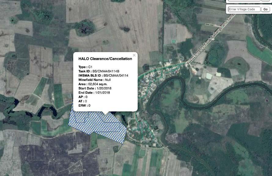
66 65

67 W Sdok Bravek commune - Site #2 Sdok Bravek commune, Rukhak Kiri district, Battambang province This site was of concern during the non-technical risk assessment field visit, as it became clear that the planned network entered an unreleased minefield polygon. The report stated: The situation in the Sdok Bravek II network is far less positive than anticipated, from comments made on the previous visit to the Sdok Bravek I site. The southern end of the network is planned to access Canal 18, but either side of the canal is an assessed minefield (BS 02825, A2 mixed AT and AP mines). Despite the CMAC district focal point stating that 15 metres either side of the laterite road that goes south to the canal and beyond has been cleared, the MAPU chief in Battambang clearly stated that this, and other polygons on both sides of the canal (Canal 18) and for some distance above, and one polygon below where the network is planned to access the canal, have not been cleared nor are they on the work plan for Below: network track crosses an unreleased BLS minefield polygon. The Sdok Bravek II site, like Ung Virak, has provided one of the rare occasions so far where technical survey has been needed to verify the risks as being acceptable. The HALO Trust report concluded: Having conducted 31 non-technical surveys and reviewed the 3i tasking order, a further six technical surveys (clearance) were conducted in targeted areas (parts of BLS polygon codes and 02821, and housing that was built on contaminated soil taken from BLS polygon 02825). Three accidents recorded by CMVIS were investigated: AT mine accident recorded in 2001 near the project network - in fact this occurred in Chong Poaor village, along Canal 17, about 12 km away from where it was recorded, which killed 3 people on an ox cart. It is believed that the wrong coordinates were collected. 66
68 UXO accident recorded in 2005 about 200 m to the south of the network - a 60 mm mortar was initiated when a student was handling the item behind the school yard; he was injured. AP mine accident recorded in it in fact occurred in Mukh Rea village about 5 km to the east from where it was wrongly recorded. The team also conducted sixteen EOD call-outs adjacent to the water network, locating and destroying 37 items (28 of which were stray ammunition - safe to move and two landmines). Information available indicates these landmines (Type 69 and Type 72a) were found over 2 km from the nearest point of the irrigation project on land so well used it was deemed not necessary to produce a survey report. HALO s assessment is that further stray ammunition is likely to be encountered whilst implementing this irrigation project though the threat of mines and cluster munitions is low. Contractors will need to receive thorough risk education and the provision of EOD call-out. 67


69 E Chantha En, Krang Skear commune, Tuek Phos district, Kompong Chhnang province The final case study is still classified as a working draft at the time of writing as HALO has not yet completed its technical risk assessment, although it is scheduled to take place over the coming days. The site is included as it is a good example of the discovery of what might be called low-hanging fruit, where limited numbers of unreleased minefields pose a threat to the community but are not being prioritised for clearance by the national planning process as they are in provinces which are considered to be low priority. The following is reproduced from the advisor s nontechnical risk assessment field visit report: Above: BS/CMAA/ A4 in Trapeang Mlu village sits on the reverse slope of the hill immediately behind the school. It is a high-risk minefield containing PMN2 mines but does not pose a threat to construction of the electricity network, although HALO should brief the operator s workers on the risk as the network runs alongside the road on either side of the hill i.e. do not enter the hazardous area. Left: the polygon as recorded in IMSMA, and shown on the mobile Fulcrum app. Although the area is classified as A4, it could possibly be considered as A1 given the density of mines and their high functionality even allowing for the passage of time. NB it should be noted that the network is shown as a redorange line on the Fulcrum mobile app maps. 68


70 In Trapeang Mlu the team spoke to a long-term resident and former soldier who claimed to have actually laid the mines in He is a friend of the village leader who was unavailable during the time of our visit. He stated that people do enter the hazardous area, but there have been no reported accidents to date. There were a lot of mines planted in this area in the 1980s. Later in the interview he estimated that while he has attempted to informally demine the area, removing 3-4 mines, there are perhaps as many as mines left. Given that this is a 9500 m2 minefield this is quite dense. They laid PMN2 and POMZ mines. During the war there had been a military base on top of the hill and the mines were laid as defence from Khmer Rouge units infiltrating from the south west. He stated that last year CMAC responded to an item of ERW (believed to be a UXO) just off the road, to the west of the village leader s house. The item had been discovered and the commune chief was called and reported it to CMAC. In Krang Skear Tboung village the village leader was not available but was interviewed over the phone. He noted that a UXO was discovered and destroyed in the village two months ago. The village leader s house, as illustrated left, is actually located in one of a series of A4 SHAs to the south of the village. The blue line, running south of and parallel to the railway that is due for refurbishment in the coming months, is the main Phnom Penh-Pursat powerline, also illustrated below. This was cleared completely by the RCAF s demining unit NPMEC in The village leader, a former soldier who fought in the area cleared the area around his home, reportedly finding many items. The polygons were mapped (and perhaps fenced) by CMAC in 2012, and mine signs placed on the edges. However, the village leader stated that he removed the mine signs as no clearance was planned and has started to clear these areas himself (threatreduced). He has started in the most southerly of these SHAs. He noted that during the 1980s both the Khmer Rouge and Vietnamese laid mines in these areas, as it was an area where troops would retreat after an attack on the village. He noted that villagers have found a lot of items of ERW along the roadsides. Left: the location of an anti-tank mine found when the road was constructed, just outside the police post in Krang Skear Tboung. The presence of an assessed threat in such close proximity to the network is clearly of concern, and therefore HALO was tasked to review the area. 69
71 Conclusion In post-conflict countries, there will always be some risk from residual ERW threats when construction is undertaken, as witnessed by ongoing efforts to manage risk from UXO in Europe. 3i s ERW risk management policy and the management model that has grown from this has been an innovative attempt to adopt good practice approaches to the issue in Cambodia. Although lessons are still being learned in real time, it has proven a cost-effective and efficient method that makes sense of risk in a logical and systematic way. It became evident early in the process that, given the length of the networks being supported, more traditional approaches that can be thought of as threat eradication (i.e. full clearance of the area through which the networks would be installed) would have rendered the entire programme non-economic. Equally, given the proximity of residual ERW threats to the areas through which networks were being constructed, doing nothing was also not an option, and would equally have imperilled the 3i programme. The old approach of avoiding areas where ERW threats were reported would also have constricted the scale and reach of the 3i initiative, needlessly reducing its access and impact. The approach adopted, rooted in systematically assessing and then managing risks from ERW threats, has demonstrated that all reasonable effort, as defined above, has been taken to reduce the risks as far as is reasonable and practicable. Stakeholders most at risk have been briefed about the residual risks, and the networks constructed by operators supported by 3i grants have started to deliver piped drinking water and electricity, in many cases for the first time, to an impressively large section of the Cambodian people. 70

72 Annex 1. Land classification standard Source: CMAA (2013a) 71

73 Supported with the kind contribution of the United States of America Geneva International Centre for Humanitarian Demining Maison de la paix, Tower 3, Chemin Eugène-Rigot 2C PO Box 1300, CH 1211 Geneva 1, Switzerland gichd.org
PERFORMANCE SCORE: AVERAGE
 CAMBODIA PROGRAMME PERFORMANCE 2017 2016 Problem understood 5 5 Target date for completion of cluster munition clearance 5 5 Targeted clearance 6 6 Efficient clearance 5 5 National funding of programme
CAMBODIA CAMBODIA ARTICLE 5 DEADLINE: 1 JANUARY 2020 (NOT ON TRACK TO MEET DEADLINE) PROGRAMME PERFORMANCE For 2015 For 2014
 PROGRAMME PERFORMANCE For 2015 For 2014") STATES PARTIES ARTICLE 5 DEADLINE: 1 JANUARY 2020 (NOT ON TRACK TO MEET DEADLINE) PROGRAMME PERFORMANCE For 2015 For 2014 Problem understood 8 8 Target date for completion of mine clearance 6 6 Targeted
STATES PARTIES ARTICLE 5 DEADLINE: 1 JANUARY 2020 (NOT ON TRACK TO MEET DEADLINE) PROGRAMME PERFORMANCE For 2015 For 2014 Problem understood 8 8 Target date for completion of mine clearance 6 6 Targeted
KINGDOM OF CAMBODIA PRESENTATION TO THE CCW PROTOCOL V ON CLEARANCE, REMOVAL OR DESTRUCTION ON MINE/ERW GENEVA, APRIL 2009
 KINGDOM OF CAMBODIA PRESENTATION TO THE CCW PROTOCOL V ON CLEARANCE, REMOVAL OR DESTRUCTION ON MINE/ERW GENEVA, 22-24 APRIL 2009 By HE. Chum Bun Rong, Head of Cambodian Delegation Advisor to the Prime
COMPLIANCE REPORTING FORMS COVER PAGE
 REPORTING FORMS pursuant to the Decision of the Third CCW Review Conference on the establishment of a Compliance mechanism applicable to the Convention, as contained in its Final Declaration, Annex II,
RELEVANCE OF INTERNATIONAL LAW AND STANDARDS TO THE PILLARS OF MINE ACTION
 these national standards is sometimes called into question owing to the manner in which they were promulgated and the clarity of the underlying legislation. In most cases NMAS are recognised and used by
National Mine Action Strategy
 Kingdom of Cambodia Nation Religion King National Mine Action Strategy 2010-2019 Approved by the Royal Government of Cambodia On 11 November, 2010 1 FOREWORD Samdech Akka Moha Sena Padei Techo Hun Sen
KINGDOM OF CAMBODIA Nation Religion King
 KINGDOM OF CAMBODIA Nation Religion King PROTOCOL ON PROHIBITIONS OR RESTRICTIONS ON THE USE OF MINES, BOOBY-TRAPS AND OTHER DEVICES, AS AMENDED ON 3 MAY 1996, ANNEXED TO THE CONVENTION ON PROHIBITIONS
UNMAS NEWS. more than mines GAZA UPDATE JAN UA RY The Crisis BY THE NUMBERS. unmas.org. 228 UN sites cleared of ERW
 NEWS JAN UA RY 2 0 1 5 GAZA UPDATE The Crisis The latest escalation of hostilities between Israel and Gaza (8 July-26 August 2014) caused unprecedented damage and destruction in Gaza. During the hostilities,
Convention on Certain Conventional Weapons (CCW)
") It resulted in the adoption of treaties which can be labelled humanitarian disarmament. In addition to establishing an absolute ban on the use, production, transfer and stockpiling of certain types of
It resulted in the adoption of treaties which can be labelled humanitarian disarmament. In addition to establishing an absolute ban on the use, production, transfer and stockpiling of certain types of
KINGDOM OF CAMBODIA Nation Religion King
 KINGDOM OF CAMBODIA Nation Religion King PROTOCOL ON PROHIBITIONS OR RESTRICTIONS ON THE USE OF MINES, BOOBY-TRAPS AND OTHER DEVICES, AS AMENDED ON 3 MAY 1996, ANNEXED TO THE CONVENTION ON PROHIBITIONS
KOBANI A city of rubble and unexploded devices
 FACTSHEET MAY 2015 Advocacy KOBANI A city of rubble and unexploded devices In April 2015, Handicap International assessed the damage caused by the fighting in the city of Kobani and the surrounding villages.
KINGDOM OF CAMBODIA CONVENTION ON THE PROHIBITION OF THE USE, STOCKPILING, PRODUCTION AND TRANSFER OF ANTI-PERSONNEL MINES AND ON THEIR DESTRUCTION
 KINGDOM OF CAMBODIA CONVENTION ON THE PROHIBITION OF THE USE, STOCKPILING, PRODUCTION AND TRANSFER OF ANTI-PERSONNEL MINES AND ON THEIR DESTRUCTION Reporting Formats for Article 7 STATE PARTY: POINT OF
Model Law Convention on Cluster Munitions
 ADVISORY SERVICE ON INTERNATIONAL HUMANITARIAN LAW Model Law Convention on Cluster Munitions Legislation for Common Law States on the 2008 Convention on Cluster Munitions International Committee of the
Explosive weapons in populated areas - key questions and answers
 BACKGROUND PAPER JUNE 2018 Explosive weapons in populated areas - key questions and answers The International Network on Explosive Weapons (INEW) is an NGO partnership calling for immediate action to prevent
NAME OF HIGH CONTRACTING PARTY New Zealand DATE OF SUBMISSION 7 September 2007 NATIONAL POINT OF CONTACT
 REPORT BY NEW ZEALAND PURSUANT TO DECISION 3, PARAGRAPH 5, OF THE FINAL DECLARATION OF THE THIRD REVIEW CONFERENCE OF THE HIGH CONTRACTING PARTIES TO THE CONVENTION ON PROHIBITIONS OR RESTRICTIONS ON THE
Evaluation Questions for Lesson 2.2. General. Narrative Note: Frame narrative evaluations as questions, requests or directions.
 Evaluation Notes on Use: Types of learning evaluation questions are: 1) 2) Fill in the blank/sentence completion 3) True-False Combine in different ways for pre-assessment and post-assessment. Each evaluation
The CDB-based Poverty and Select CMDGs Maps and Charts
 An unofficial research report of the Ministry of Planning with support from the United Nations Development Programme, Cambodia. The publication contains findings of the Commune Database analysis and is
2017 Annual Report on the implementation of the Mine Action Strategy of the Swiss Confederation
 Federal Department of Foreign Affairs (FDFA) Federal Department of Defence, Civil Protection and Sport (DDPS) 2017 Annual Report on the implementation of the Mine Action Strategy of the Swiss Confederation
CONVENTION ON THE PROHIBITION OF THE USE, STOCKPILING, PRODUCTION AND TRANSFER OF ANTI-PERSONNEL MINES AND ON THEIR DESTRUCTION
 CONVENTION ON THE PROHIBITION OF THE USE, STOCKPILING, PRODUCTION AND TRANSFER OF ANTI-PERSONNEL MINES AND ON THEIR DESTRUCTION Reporting Formats for Article 7 STATE PARTY: AUSTRALIA DATE OF SUBMISSION
CONTAMINATION BACKGROUND AND ERW RISK MANAGEMENT IN VIETNAM
 CONTAMINATION BACKGROUND AND ERW RISK MANAGEMENT IN VIETNAM CONTENT 1. Background and consequences of ERW in Vietnam 2. Identify and implement prioritized objectives of Mine action in Vietnam 3. ERW risk
CONVENTION ON CLUSTER MUNITIONS REPORTING FORMATS FOR ARTICLE 7 OF THE CONVENTION ON CLUSTER MUNITIONS
 CONVENTION ON CLUSTER MUNITIONS REPORTING FORMATS FOR ARTICLE 7 OF THE CONVENTION ON CLUSTER MUNITIONS STATE : Canada.. NATIONAL POINT(S) OF CONTACT: Non-proliferation and Disarmament Division (IGN) Department
CHAPTER 5 THE CONVENTION ON CERTAIN CONVENTIONAL WEAPONS
 69 SUMMARY The 1980 Convention on Certain Conventional Weapons (CCW) is an instrument of international humanitarian law that regulates the use, and in certain circumstances also the transfer, of specific
COVER PAGE 1 OF THE ANNUAL ARTICLE 7 REPORT NAME OF STATE [PARTY]: ESTONIA. REPORTING PERIOD: to
![COVER PAGE 1 OF THE ANNUAL ARTICLE 7 REPORT NAME OF STATE [PARTY]: ESTONIA. REPORTING PERIOD: to](/thumbs/93/111690406.jpg "COVER PAGE 1 OF THE ANNUAL ARTICLE 7 REPORT NAME OF STATE [PARTY]: ESTONIA. REPORTING PERIOD: to") COVER PAGE 1 OF THE ANNUAL ARTICLE 7 REPORT NAME OF STATE [PARTY]: ESTONIA REPORTING PERIOD: 01.01.2014 to 31.12.2014 (dd/mm/yyyy) Form A: National implementation measures: Form B: Stockpiled anti-personnel
COVER PAGE 1 OF THE ANNUAL ARTICLE 7 REPORT NAME OF STATE [PARTY]: ESTONIA REPORTING PERIOD: 01.01.2014 to 31.12.2014 (dd/mm/yyyy) Form A: National implementation measures: Form B: Stockpiled anti-personnel
THAILAND PROGRAMME PERFORMANCE ARTICLE 5 DEADLINE: 31 OCTOBER 2023 (UNCLEAR WHETHER ON TRACK TO MEET DEADLINE)
") STATES PARTIES THAILAND ARTICLE 5 DEADLINE: 31 OCTOBER 2023 (UNCLEAR WHETHER ON TRACK TO MEET DEADLINE) PROGRAMME PERFORMANCE 2017 2016 Problem understood 8 7 Target date for completion of mine clearance
STATES PARTIES THAILAND ARTICLE 5 DEADLINE: 31 OCTOBER 2023 (UNCLEAR WHETHER ON TRACK TO MEET DEADLINE) PROGRAMME PERFORMANCE 2017 2016 Problem understood 8 7 Target date for completion of mine clearance
DEMOCRATIC REPUBLIC OF CONGO
 DEMOCRATIC REPUBLIC OF CONGO (CLEARANCE COMPLETED IN 2017) PROGRAMME PERFORMANCE 2016 2015 Problem understood 9 8 Target date for completion of cluster munition clearance 7 7 Targeted clearance 8 7 Efficient
APLC/MSP.13/2013/WP.10
 Meeting of the States Parties to the Convention on the Prohibition of the Use, Stockpiling, Production and Transfer of Anti-Personnel Mines and on Their Destruction APLC/MSP.13/2013/WP.10 29 October 2013
REPUBLIC OF SERBIA CASE PRESENTATION ON ERW
 REPUBLIC OF SERBIA CASE PRESENTATION ON ERW INTRODUCTION CONVENTIONS AND PROTOCOLS RELATED TO WEAPONS: Geneva Gas Protocol 1925 BWC 1972 CCW 1980 CCW Protocol I 1980 CCW Protocol II 1980 CCW Protocol III
Geneva International Centre for Humanitarian Demining MINE RISK EDUCATION IN JORDAN: A PRELIMINARY NEEDS AND CAPACITIES ASSESSMENT
 Geneva International Centre for Humanitarian Demining MINE RISK EDUCATION IN JORDAN: A PRELIMINARY NEEDS AND CAPACITIES ASSESSMENT Amman, November 2005 1 Contents INTRODUCTION... 4 Summary of methodology...
DISEC: The Question of Cluster Munitions Cambridge Model United Nations 2018
 Study Guide Committee: United Nations Disarmament and International Security Council (DISEC) Topic: The Question of Cluster Munitions Introduction: Cluster munitions are an air-dropped or ground-launched
2015 Annual Report on the Implementation of the Mine Action Strategy of the Swiss Confederation
 Federal Department of of Foreign Affairs (FDFA) Federal Department of Defence, Civil Protection and Sport (DDPS) 2015 Annual Report on the Implementation of the Mine Action Strategy of the Swiss Confederation
DEMOCRATIC REPUBLIC OF CONGO
 DEMOCRATIC REPUBLIC OF CONGO PROGRAMME PERFORMANCE 2015 2014 Problem understood 8 8 Target date for completion of cluster munition clearance 7 7 Targeted clearance 7 7 Efficient clearance 7 7 National
Handover of released land. Common Procedures and Good Practices
 Handover of released land Common Procedures and Good Practices Gender and Mine Action Programme and Geneva International Center for Humanitarian Demining Geneva - 2013 Cover photo: Woman working her land
2014 Annual Report on the Implementation of the Mine Action Strategy of the Swiss Confederation
 Federal Department of of Foreign Affairs (FDFA) Federal Department of Defence, Civil Protection and Sport (DDPS) 2014 Annual Report on the Implementation of the Mine Action Strategy of the Swiss Confederation
THE CONVENTION ON THE PROHIBITION 9 October 2008 OF THE USE, STOCKPILING, PRODUCTION AND TRANSFER OF ANTI-PERSONNEL
 MEETING OF THE STATES PARTIES TO THE CONVENTION ON THE PROHIBITION 9 October 2008 OF THE USE, STOCKPILING, PRODUCTION AND TRANSFER OF ANTI-PERSONNEL MINES AND ON THEIR DESTRUCTION Original: ENGLISH Ninth
Draft Protocol on cluster munitions. 26 August 2011, 3:00 p.m. Submitted by the Chairperson
 Group of Governmental Experts of the High Contracting Parties to the Convention on Prohibitions or Restrictions on the Use of Certain Conventional Weapons Which May Be Deemed to Be Excessively Injurious
Number 20 of 2008 CLUSTER MUNITIONS AND ANTI-PERSONNEL MINES ACT 2008 ARRANGEMENT OF SECTIONS. PART 1 Preliminary and General
 Number 20 of 2008 CLUSTER MUNITIONS AND ANTI-PERSONNEL MINES ACT 2008 ARRANGEMENT OF SECTIONS PART 1 Preliminary and General Section 1. Short title and commencement. 2. Interpretation. 3. Laying of orders
MINURSO (UN Mission for the Referendum in Western Sahara)
") MINURSO (UN Mission for the Referendum in Western Sahara) 2017 Summary Graphs Fund Detail By Agency By 6M 4M Organization Type Area of work 2M Budget Amount (USD) Shortfall UN Gov International NGO National
MINURSO (UN Mission for the Referendum in Western Sahara) 2017 Summary Graphs Fund Detail By Agency By 6M 4M Organization Type Area of work 2M Budget Amount (USD) Shortfall UN Gov International NGO National
KINGDOM OF CAMBODIA CONVENTION ON THE PROHIBITION OF THE USE, STOCKPILING, PRODUCTION AND TRANSFER OF ANTI-PERSONNEL MINES AND ON THEIR DESTRUCTION
 KINGDOM OF CAMBODIA CONVENTION ON THE PROHIBITION OF THE USE, STOCKPILING, PRODUCTION AND TRANSFER OF ANTI-PERSONNEL MINES AND ON THEIR DESTRUCTION Reporting Formats for Article 7 STATE PARTY: POINT OF
Monitoring and Evaluation Mechanism for the UN Strategy for Mine Action :
 Monitoring and Evaluation Mechanism for the UN Strategy for Mine Action 01-018: Contents Report from the rd Round of Data Collection May 016 1. Executive Summary.... Introduction....1 Data and Analysis....
COMMISSION DECISION C/2006/2202 of 09/06/2006. on a preparatory action programme continuing de-mining activities in Cyprus in 2006
 COMMISSION DECISION C/2006/2202 of 09/06/2006 on a preparatory action programme continuing de-mining activities in Cyprus in 2006 THE COMMISSION OF THE EUROPEAN COMMUNITIES, Having regard to the Treaty
Mine Action Assessment
 Mine Action Assessment Northeastern Nigeria (Adamawa and Borno States) 1-15 November 2015 1. BACKGROUND Nigeria s northeast is currently experiencing a significant humanitarian crisis, which has resulted
Ministry for Foreign Affairs Sweden
 Ministry for Foreign Affairs Sweden Article 7 Report Covering 2011 CONVENTION ON THE PROHIBITION OF THE USE, STOCKPILING, PRODUCTION AND TRANSFER OF ANTI-PERSONNEL MINES AND ON THEIR DESTRUCTION 1 COVER
PROGRAMME PERFORMANCE
 ARTICLE 5 DEADLINE: 1 APRIL 2019 (FOUR-YEAR EXTENSION REQUESTED TO 1 APRIL 2023) PROGRAMME PERFORMANCE 2017 2016 Problem understood 6 5 Target date for completion of mine clearance 4 3 Targeted clearance
OBSERVATIONS ON THE LEGAL ISSUES RELATED TO THE USE OF CLUSTER MUNITIONS
 GROUP OF GOVERNMENTAL EXPERTS OF THE STATES PARTIES TO THE CONVENTION ON PROHIBITIONS OR RESTRICTIONS ON THE USE OF CERTAIN CONVENTIONAL WEAPONS WHICH MAY BE DEEMED TO BE EXCESSIVELY INJURIOUS OR TO HAVE
Convention on Cluster Munitions, 30 May 2008
 The States Parties to this Convention, Convention on Cluster Munitions, 30 May 2008 Deeply concerned that civilian populations and individual civilians continue to bear the brunt of armed conflict, Determined
APLC/MSP.14/2015/WP.7
 Meeting of the States Parties to the Convention on the Prohibition of the Use, Stockpiling, Production and Transfer of Anti-Personnel Mines and on Their Destruction 19 November 2015 Original: English Fourteenth
Explosive weapons in populated areas - key questions and answers
 BACKGROUND PAPER AUGUST 2014 Explosive weapons in populated areas - key questions and answers The International Network on Explosive Weapons (INEW) is an NGO partnership calling for immediate action to
National Capacities and Residual Contamination
 Geneva International Centre for Humanitarian Demining Chemin Eugène-Rigot 2C PO Box 1300, CH - 1211 Geneva 1, Switzerland T +41 (0)22 730 93 60 info@gichd.org, www.gichd.org National Capacities and Residual
WESTERN SAHARA WESTERN SAHARA. PROGRAMME PERFORMANCE For 2015 For 2014
 WESTERN SAHARA PROGRAMME PERFORMANCE For 2015 For 2014 Problem understood 7 7 Target date for completion of mine clearance 3 3 Targeted clearance 7 7 Efficient clearance 7 7 National funding of programme
Appendix II. Protocol on Explosive Remnants of War
 Page 25 Appendix II Protocol on Explosive Remnants of War The High Contracting Parties, Recognising the serious post-conflict humanitarian problems caused by explosive remnants of war, Conscious of the
CONVENTION ON THE PROHIBITION OF THE USE, STOCKPILING, PRODUCTION AND TRANSFER OF ANTI-PERSONNEL MINES AND ON THEIR DESTRUCTION
 CONVENTION ON THE PROHIBITION OF THE USE, STOCKPILING, PRODUCTION AND TRANSFER OF ANTI-PERSONNEL MINES AND ON THEIR DESTRUCTION Reporting Formats for Article 7 1 STATE PARTY: The Kingdom of the Netherlands
CONVENTION ON THE PROHIBITION OF THE USE, STOCKPILING, PRODUCTION AND TRANSFER OF ANTI-PERSONNEL MINES AND ON THEIR DESTRUCTION
 CONVENTION ON THE PROHIBITION OF THE USE, STOCKPILING, PRODUCTION AND TRANSFER OF ANTI-PERSONNEL MINES AND ON THEIR DESTRUCTION Reporting Formats for Article 7 STATE [PARTY]: THE KINGDOM OF CAMBODIA POINT
I heard a big bang and saw smoke. When the smoke cleared my right leg was gone and my left was bleeding. Kheun Sokhon, 24
 Curiosity kills I heard a big bang and saw smoke. When the smoke cleared my right leg was gone and my left was bleeding. Kheun Sokhon, 24 The problem Imagine if, somewhere outside your front door, there
CARTAGENA ACTION PLAN : ENDING THE SUFFERING CAUSED BY ANTI-PERSONNEL MINES
 SECOND REVIEW CONFERENCE OF THE UNOFFICIAL VERSION STATES PARTIES TO THE CONVENTION 11 December 2009 ON THE PROHIBITION OF THE USE, STOCKPILING, PRODUCTION AND TRANSFER OF ANTI-PERSONNEL MINES AND ON THEIR
CAMBODIA MINE/ERW VICTIM INFORMATION SYSTEM
 អ ជ ញ ធរម នកមព ជ ញ C.M.A.A CAMBODIA MINE/ VICTIM INFORMATION SYSTEM MONTHLY REPORT FOR DECEMBER 7 Background The Cambodia / Victim Information System (CMVIS) established in 99 by the Cambodian Red Cross
MUNA Introduction. General Assembly First Committee Eradicating landmines in post- conflict areas
 Forum: Issue: Student Officer: General Assembly First Committee Eradicating landmines in post- conflict areas Mariam Tsagikian Introduction The concern about the effects of certain conventional weapons,
REPORTING FORMS NAME OF THE HIGH CONTRACTING PARTY: NEW ZEALAND
 Page 1 REPORTING FORMS pursuant to the Decision of the Third CCW Review Conference on the establishment of a Compliance mechanism applicable to the Convention, as contained in its Final Declaration, Annex
Prepared by the United Nations Inter-Agency Coordination Group on Mine Action
 Monitoring and Evaluation Mechanism for the United Nations Strategy for Mine Action 2013-2018: Report from the 5 th Round of Data Collection March 2017 Prepared by the United Nations Inter-Agency Coordination
EXPLOSIVE REMNANTS OF WAR
 EXPLOSIVE REMNANTS OF WAR International Committee of the Red Cross 19, avenue de la Paix 1202 Geneva, Switzerland T +41 22 734 60 01 F +41 22 733 20 57 Email: shop@icrc.org www.icrc.org ICRC, December
* * APLC/CONF/2014/WP.4
 Third Review Conference of the States Parties to the Convention on the Prohibition of the Use, Stockpiling, Production and Transfer of Anti-Personnel Mines and on Their Destruction 5 June 2014 Original:
to peace and reconciliation
 Removing physical barriers to peace and reconciliation Landmine and Ordnance clearance in Cyprus www.undp-pff.org table of contents 5 7 8 10 13 page 2 3 page Mine clearance prevents an indiscriminate weapon
SUMMARY COVER PAGE OF THE ANNUAL REPORT OF CCW PROTOCOL V 1. New Zealand. REPORTING PERIOD: 01/01/2013 To 31/12/2013 (dd/mm/yyyy) (dd/mm/yyyy)
 (dd/mm/yyyy)") SUMMARY COVER PAGE OF THE ANNUAL REPORT OF CCW PROTOCOL V 1 NAME OF STATE [PARTY]: New Zealand REPORTING PERIOD: 01/01/2013 To 31/12/2013 (dd/mm/yyyy) (dd/mm/yyyy) Form A: Steps taken implement Article
SUMMARY COVER PAGE OF THE ANNUAL REPORT OF CCW PROTOCOL V 1 NAME OF STATE [PARTY]: New Zealand REPORTING PERIOD: 01/01/2013 To 31/12/2013 (dd/mm/yyyy) (dd/mm/yyyy) Form A: Steps taken implement Article
CONVENTION ON THE PROHIBITION OF THE USE, STOCKPILING, PRODUCTION AND TRANSFER OF ANTI-PERSONNEL MINES AND THEIR DESTRUCTION
 CONVENTION ON THE PROHIBITION OF THE USE, STOCKPILING, PRODUCTION AND TRANSFER OF ANTI-PERSONNEL MINES AND THEIR DESTRUCTION ARTICLE 7 REPORT STATE PARTY : REPUBLIC OF ZAMBIA DATE OF SUBMISSION : 3 rd
Convention on Cluster Munitions
 Convention on Cluster Munitions Reporting formats for article 7 of the Convention on Cluster Munitions State [Party]: SWEDEN National point(s) of contact (organization, telephones, fax, e-mail) 1 : Ministry
DIPLOMATIC CONFERENCE FOR THE ADOPTION OF A CONVENTION ON CLUSTER MUNITIONS
 DIPLOMATIC CONFERENCE FOR THE ADOPTION OF A CONVENTION ON CLUSTER MUNITIONS CCM/77 30 May 2008 Original: ENGLISH FRENCH SPANISH DUBLIN 19 30 MAY 2008 The States Parties to this Convention, Convention on
THE ANTI-PERSONNEL MINES AND CLUSTER MUNITIONS (PROHIBITION) BILL (No. VIII of 2016) Explanatory Memorandum
 BILL (No. VIII of 2016) Explanatory Memorandum") THE ANTI-PERSONNEL MINES AND CLUSTER MUNITIONS (PROHIBITION) BILL (No. VIII of 2016) Explanatory Memorandum The object of this Bill is to give effect to the Convention on the Prohibition of the Use, Stockpiling,
THE ANTI-PERSONNEL MINES AND CLUSTER MUNITIONS (PROHIBITION) BILL (No. VIII of 2016) Explanatory Memorandum The object of this Bill is to give effect to the Convention on the Prohibition of the Use, Stockpiling,
Recognizing that a total ban of anti-personnel mines would also be an important confidence-building measure,
 Convention on the Prohibition of the Use, Stockpiling, Production and Transfer of Anti-Personnel Mines and on Their Destruction Preamble The States Parties, Determined to put an end to the suffering and
The Anti-Personnel Mine Ban Law. Law Number 10 for the year 2008
 TRANSLATED FROM THE ORIGINAL ARABIC VERSION The Anti-Personnel Mine Ban Law Law Number 10 for the year 2008 The National Committee for Demining and Rehabilitation April 2008 Amman, Jordan Law Number 10
REPUBLIC OF THE SUDAN
 REPUBLIC OF THE SUDAN UPDATED ARTICLE 7 REPORT (01 January 2012-31 December ) On the Convention on the Prohibition of the Use, Stockpiling, Production and Transfer of Anti-Personnel Mines and on their
REPUBLIC OF THE SUDAN
 REPUBLIC OF THE SUDAN UPDATED ARTICLE 7 REPORT (01 January 2012-31 December 2012) On the Convention on the Prohibition of the Use, Stockpiling, Production and Transfer of Anti-Personnel Mines and on their
Mission creep or responding to wider security needs? The evolving role of mine action organisations in Armed Violence Reduction
 stability Naidoo, S 2013 Mission creep or responding to wider security needs? The evolving role of mine action organisations in Armed Violence Reduction. Stability, 2(1): 11, pp. 1-8, DOI: http://dx.doi.org/10.5334/sta.av
Remarks. Mr. Marwan Francis. at the. UNDP Briefing on Development and Mine Action
 Remarks by Mr. Marwan Francis at the UNDP Briefing on Development and Mine Action New York, July 12, 2016 Check against Delivery First, allow me to thank UNDP and UNDP s Assistant Administrator for convening
Cover page 1 of the annual article 7 report
 Cover page 1 of the annual article 7 report Name of State Party: MOZAMBIQUE Reporting period: 01/01/2014 to 31/12/2014 Form A: National implementation measures: changed X unchanged (last reporting: 2012)
Danish Demining Group South Sudan
 Danish Demining Group South Sudan Humanitarian Accountability Framework November 2011 1. DDG South Sudan s objectives, partners and stakeholders Strategic : The provision of a safe environment for returnees
Submitted by the Committee on Article 5 Implementation (Ecuador, Ireland, Poland and Zambia)
") Analysis of the request submitted by Senegal for an extension of the deadline for completing the destruction of anti-personnel mines in accordance with Article 5 of the Convention Submitted by the Committee
Analysis of the request submitted by Senegal for an extension of the deadline for completing the destruction of anti-personnel mines in accordance with Article 5 of the Convention Submitted by the Committee
Recommendation of the Council for Development Co-operation Actors on Managing the Risk of Corruption
 Recommendation of the Council for Development Co-operation Actors on Managing the Risk of Corruption 2016 Please cite this publication as: OECD (2016), 2016 OECD Recommendation of the Council for Development
PROGRAMME PERFORMANCE 2015
 WESTERN SAHARA PROGRAMME PERFORMANCE 2015 Problem understood 7 Target date for completion of cluster munition clearance 4 Targeted clearance 7 Efficient clearance 6 National funding of programme 4 Timely
STATE : Canada (Voluntary Report)..
..") CONVENTION ON CLUSTER MUNITIONS REPORTING FORMATS FOR ARTICLE 7 OF THE CONVENTION ON CLUSTER MUNITIONS STATE : Canada (Voluntary Report).. NATIONAL POINT(S) OF CONTACT: John MacBride, Senior Defence Advisor
CONVENTION ON CLUSTER MUNITIONS REPORTING FORMATS FOR ARTICLE 7 OF THE CONVENTION ON CLUSTER MUNITIONS STATE : Canada (Voluntary Report).. NATIONAL POINT(S) OF CONTACT: John MacBride, Senior Defence Advisor
South Sudan Summary Graphs. Project By Agency. Organization Type. UN Gov International NGO National NGO
 South Sudan 2017 Summary Graphs Fund Detail By By 40M 30M Organization Type Area of work 20M 10M Budget Amount (USD) Shortfall UN Gov International NGO National NGO Clearance Risk Education Capacity Development
IMUNA 2017: Research Report - DC
 International Model United Nations of Alkmaar 2017 9 th - 11 th of June 2017 IMUNA 2017: Research Report - DC Forum: Disarmament Commission Issue: Measures to put an end to landmines, cluster munitions
MINUTES of the MINE ACTION SUPPORT GROUP MEETING 18 OCTOBER 2013 AUSTRALIAN MISSION TO THE UN
 1. WELCOMING REMARKS 1.1 Introduction by the Chair (Australia) MINUTES of the MINE ACTION SUPPORT GROUP MEETING 18 OCTOBER 2013 AUSTRALIAN MISSION TO THE UN The Chair of the Mine Action Support Group (MASG),
AMENDED PROTOCOL II REPORTING FORMATS
 PROTOCOL ON PROHIBITIONS OR RESTRICTIONS ON THE USE OF MINES, BOOBY-TRAPS AND OTHER DEVICES, AS AMENDED ON 3 MAY 1996, ANNEXED TO THE CONVENTION ON PROHIBITIONS OR RESTRICTIONS ON THE USE OF CERTAIN CONVENTIONAL
International Workshop on the Safe and Secure Management of Ammunition, Geneva (8-9 December 2016) CHAIR S SUMMARY
 CHAIR S SUMMARY") Federal Department of Foreign Affairs FDFA Federal Department of Defence Civil Protection and Sport DDPS International Workshop on the Safe and Secure Management of Ammunition, Geneva (8-9 December 2016)
Federal Department of Foreign Affairs FDFA Federal Department of Defence Civil Protection and Sport DDPS International Workshop on the Safe and Secure Management of Ammunition, Geneva (8-9 December 2016)
Territory of Western Sahara
 Territory of Western Sahara 2018 Summary Graphs Fund Detail By Agency By 5M 4M 3M 2M 1M Budget Amount (USD) Shortfall Organization Type Gov International NGO Area of work Clearance Victim assistance Capacity
COMPLIANCE REPORTING FORMS COVER PAGE
 REPORTING FORMS pursuant to the Decision of the Third CCW Review Conference on the establishment of a Compliance mechanism applicable to the Convention, as contained in its Final Declaration, Annex II,
COVER PAGE 1 OF THE ANNUAL ARTICLE 7 REPORT. REPORTING PERIOD: 01/01/2009 to 31/12/2009 (dd/mm/yyyy) (dd/mm/yyyy)
 (dd/mm/yyyy)") COVER PAGE 1 OF THE ANNUAL ARTICLE 7 REPORT NAME OF STATE [PARTY]: SWEDEN REPORTING PERIOD: 01/01/2009 to 31/12/2009 (dd/mm/yyyy) (dd/mm/yyyy) Form A: National implementation measures: X un (last reporting:
COVER PAGE 1 OF THE ANNUAL ARTICLE 7 REPORT NAME OF STATE [PARTY]: SWEDEN REPORTING PERIOD: 01/01/2009 to 31/12/2009 (dd/mm/yyyy) (dd/mm/yyyy) Form A: National implementation measures: X un (last reporting:
Affaires courantes et commentaires Current issues and comments
 Affaires courantes et commentaires Current issues and comments A new protocol on explosive remnants of war: The history and negotiation of Protocol V to the 1980 Convention on Certain Conventional Weapons
Sri Lanka National Mine Action Strategy
 James Madison University JMU Scholarly Commons Global CWD Repository Center for International Stabilization and Recovery Spring 5-2016 Sri Lanka National Mine Action Strategy 2016-2020 Ministry of Prison
Based on Swiss Sustainable Finance s Focus: Controversial weapons exclusions 1
 APPENDIX: CONTROVERS IAL WEAPONS BACKGROU ND Based on Swiss Sustainable Finance s Focus: Controversial weapons exclusions 1 A. Definition of controversial weapons It is generally accepted that democratic
2012 ANNUAL REPORT. Lebanon Mine Action Center
 2012 ANNUAL REPORT Lebanon Mine Action Center Lebanon Mine Action Center Forward Since its establishment in 1998, the Mine Action Programme of Lebanon (LMAP) has overcome many challenges and achieved great
Article 2 -Definitions. For the purpose of this Protocol:
 Protocol on Prohibitions or Restrictions on the Use of Mines, Booby-Traps and Other Devices as amended on 3 May 1996 (Protocol II to the 1980 Convention as amended on 3 May 1996) Article I - Scope of application
Consultative Workshop Report on Formulation of a National Engagement Strategy of ILC in Cambodia. May 30-31, 2013
 Consultative Workshop Report on Formulation of a National Engagement Strategy of ILC in Cambodia May 30-31, 2013 Imperial Hotel, Phnom Penh, Cambodia Organized by STAR Kampuchea with financial support
Mine Action Strategy of the Swiss Confederation
 Mine Action Strategy of the Swiss Confederation 2016 2019 Towards a world free of anti-personnel mines, cluster munitions and explosive remnants of war Back from the fieldwork in the Democratic Republic
Reporting formats. for Article 7 of the Convention on Cluster Munitions. Name of State [Party]: UNITED KINGDOM OF GREAT BRITAIN AND NORTHERN IRELAND
![Reporting formats. for Article 7 of the Convention on Cluster Munitions. Name of State [Party]: UNITED KINGDOM OF GREAT BRITAIN AND NORTHERN IRELAND](/thumbs/95/125324868.jpg "Reporting formats. for Article 7 of the Convention on Cluster Munitions. Name of State [Party]: UNITED KINGDOM OF GREAT BRITAIN AND NORTHERN IRELAND") Reporting formats for Article 7 of the Convention on Cluster Munitions Cover page 1 of the annual article 7 report Name of State [Party]: UNITED KINGDOM OF GREAT BRITAIN AND NORTHERN IRELAND Reporting
Reporting formats for Article 7 of the Convention on Cluster Munitions Cover page 1 of the annual article 7 report Name of State [Party]: UNITED KINGDOM OF GREAT BRITAIN AND NORTHERN IRELAND Reporting
Addis Ababa, Ethiopia, P.O. Box: 3243 Tel.: (251-11) Fax: (251-11)
 Fax: (251-11)") AFRICAN UNION UNION AFRICAINE UNIÃO AFRICANA Addis Ababa, Ethiopia, P.O. Box: 3243 Tel.: (251-11) 5513 822 Fax: (251-11) 5519 321 Email: situationroom@africa-union.org COMMEMORATION OF THE INTERNATIONAL
AFRICAN UNION UNION AFRICAINE UNIÃO AFRICANA Addis Ababa, Ethiopia, P.O. Box: 3243 Tel.: (251-11) 5513 822 Fax: (251-11) 5519 321 Email: situationroom@africa-union.org COMMEMORATION OF THE INTERNATIONAL
NAME OF THE HIGH CONTRACTING PARTY: ESTONIA
 CONVENTION ON PROHIBITIONS OR RESTRICTIONS ON THE USE OF CERTAIN CONVENTIONAL WEAPONS WHICH MAY BE DEEMED TO BE EXCESSIVELY INJURIOUS OR TO HAVE INDISCRIMINATE EFFECTS (CCW) Reporting Formats pursuant
PROVIDING AN EFFECTIVE RESPONSE TO THE HUMANITARIAN HARM RESULTING FROM THE USE OF EXPLOSIVE WEAPONS IN POPULATED AREAS
 BRIEFING PAPER NOVEMBER 2017 PROVIDING AN EFFECTIVE RESPONSE TO THE HUMANITARIAN HARM RESULTING FROM THE USE OF EXPLOSIVE WEAPONS IN POPULATED AREAS The International Network on Explosive Weapons (INEW)
CONVENTION ON THE PROHIBITION OF THE USE, STOCKPILING, PRODUCTION AND TRANSFER OF ANTI-PERSONNEL MINES AND ON THEIR DESTRUCTION
 CONVENTION ON THE PROHIBITION OF THE USE, STOCKPILING, PRODUCTION AND TRANSFER OF ANTI-PERSONNEL MINES AND ON THEIR DESTRUCTION Reporting Formats for Article 7 STATE PARTY: HELLENIC REPUBLIC DATE OF SUBMISSION
CONVENTION ON THE PROHIBITION OF THE USE, STOCKPILING, PRODUCTION AND TRANSFER OF ANTI-PERSONNEL MINES AND ON THEIR DESTRUCTION
 CONVENTION ON THE PROHIBITION OF THE USE, STOCKPILING, PRODUCTION AND TRANSFER OF ANTI-PERSONNEL MINES AND ON THEIR DESTRUCTION Reporting Formats for Article 7 1 STATE PARTY: IRELAND DATE OF SUBMISSION
Towards a Well-Coordinated National Statistical System in Support of Sustainable Development Goals (SDGs) National Institute of Statistics of Cambodia
 National Institute of Statistics of Cambodia") Towards a Well-Coordinated National Statistical System in Support of Sustainable Development Goals (SDGs) National Institute of Statistics of Cambodia Mission of NIS The mission of the National Institute
Towards a Well-Coordinated National Statistical System in Support of Sustainable Development Goals (SDGs) National Institute of Statistics of Cambodia Mission of NIS The mission of the National Institute