Appendix J Location of Preferred Alternative within I-5 Right-of-Way
|
|
|
- Mavis Hunter
- 5 years ago
- Views:
Transcription
1 Appendix J Location of Preferred Alternative within I-5 Right-of-Way
2
3 Appendix J Location of Preferred Alternative within I-5 Right-of-Way J.1 Introduction The Federal Way Link Extension (FWLE) Preferred Alternative would extend south from the Angle Station, cross over State Route (SR) 99 on an elevated structure, and continue along the south side of the future alignment of the Washington State Department of Transportation (WSDOT) proposed SR 509 Extension Project (SR 509 Extension) until reaching I-5. The alignment would then turn south and generally follow the west side of I-5 to Federal Way. This appendix identifies the advantages and disadvantages of shifting the Preferred Alternative 15 to 20 feet east within the I-5 right-of-way between Kent-Des Moines Road and S 320th Street. The width of the I-5 right-of-way varies along the project corridor. orth of Kent-Des Moines Road, the SR 509 Extension would require most of the available right-of-way, causing the light rail alignment to be mainly outside of the I-5 right-of-way. South of Kent-Des Moines Road, the undeveloped I-5 rightof-way ranges from 40 to 220 feet, so it can accommodate both the SR 509 Extension and a light rail alignment. Therefore, in this area the FWLE would be within the I-5 right-of-way. The analyses in the Final EIS assume that the guideway will generally follow the western edge of the interstate right-ofway while maintaining as straight an alignment as possible, to ensure that potential impacts on neighboring properties and land uses are disclosed as fully as possible given the current level of design. The assumption also reflects the general practice of agencies with jurisdiction over interstate highways (in Washington state, the Federal Highway Administration [FHWA] and WSDOT) to locate non-highway uses as far as possible from an existing highway. There are several reasons for this approach, including the following: Safety: As the distance diminishes between the proposed non-highway structure and the highway pavement, the risk to highway users increases. The level of hazard at any location depends on factors like the specific highway configuration, location-specific highway volumes, average speeds, topography, and the distance from the edge of pavement to a structure/barrier. The effect could be a very slight increase in the accident rate or a substantial increase, depending on the factors involved. Safety mitigation measures may help, but WSDOT and FHWA believe they would not fully mitigate safety concerns. For example, a guardrail in front of the structure may mitigate the increased hazard of a non-highway use s large concrete pier, but guardrails themselves are potential hazards. Future highway-related needs for the right-of-way: The highway agencies must also determine that any use of the right-of-way leaves enough room to accommodate reasonably foreseeable highway expansion needs, considering the width of the right-of-way and the anticipated regional growth. Even if introduction of a non-highway use does not preclude highway expansion, such Federal Way Link Extension J-1 Final EIS ovember 2016
4 Appendix J Location of Preferred Alternative within I-5 Right-of-Way projects become more difficult and expensive if there is inadequate right-of-way in which to work. In addition to potentially needing right-of-way for new lanes, highway agencies may also need it for other requirements, including new or improved drainage/stormwater facilities, signage, new or existing technologies to improve traffic management, environmental mitigation, and innovative interchange designs. For example, grassy swales within a right-of-way provide an effective stormwater treatment. They can be replaced with concrete vaults, but vaults are more costly and require more maintenance. Operations and maintenance: The highway agencies must also maintain their roadways. As the amount of right-of-way decreases, the likelihood that maintenance will disrupt traffic increases. If maintenance vehicles have to use the highway shoulders, that also increases risk to motorists. Just as insufficient right-of-way can make new construction more costly, it can increase maintenance costs. FHWA and WSDOT recognize that site-specific constraints along the undeveloped right-of-way exist and may require flexibility to adjust the light rail guideway location to minimize or avoid impacts as design progresses. For example, moving a guideway closer to the pavement from the edge of the rightof-way in some locations could reduce visual and noise impacts; it may avoid or reduce impacts to streams or wetlands or other natural features at a specific location; it may resolve constructability conflicts or increased cost from working in or around existing infrastructure in the area; or it may mitigate or avoid other impacts that would exist if the guideway were on the edge of the right-of-way. However, moving the guideway may increase impacts on highway safety, limit future highway right-ofway needs, and/or complicate highway operations and maintenance. To inform the definition of the Preferred Alternative and to provide an initial evaluation of the tradeoffs described above, Sound Transit compared two potential configurations of the Preferred Alternative south of Kent-Des Moines Road (Exhibit J-1). The western alignment would generally be along the western limit of the I-5 right-of-way. 1 This configuration is analyzed in the main body of this Final EIS as the Preferred Alternative (and portions of the SR 99 to I-5 Alternative that are in the I-5 right-of-way). Since the Draft EIS was published in April 2015, Sound Transit has advanced the design of the western alignment (i.e., the Preferred Alternative), resulting in some changes to the configuration analyzed in the Draft EIS. For example, the Preferred Kent/Des Moines Station location requires an alignment farther west away from the I-5/ Kent-Des Moines Road interchange. Similarly, to avoid impacts on the Puget Sound Energy substation at S 221st Street, the refined design has shifted east. This shift would not affect the SR 509 Extension, based on its 2003 design documented in FHWA s Record of Decision (ROD). 1 The western limit of the right-of-way is not a straight line. The boundary changes at 90-degree angles throughout the corridor, as shown on Exhibits J-2a through 2d. The light rail guideway cannot follow such angles. Accordingly, the Preferred Alternative alignment does not exactly follow the right-of-way edge. Federal Way Link Extension J-2 Final EIS ovember 2016

5 Appendix J Location of Preferred Alternative within I-5 Right-of-Way EXHIBIT J-1 Potential Locations of Preferred Alternative within WSDOT Right-of-Way (looking south) This appendix examines an eastern alignment about 15 to 20 feet east of the Preferred Alternative. It compares the implications of both configurations for environmental impacts as well as impacts on future use of the right-of-way for highway purposes as described above. This shift would be possible for approximately 14,250 feet, or 2.7 miles, between S 240th Street and S 317th Street. Sound Transit must secure agreements and approvals from WSDOT and FHWA to use the I-5 right-ofway for the Preferred Alternative, or to modify other parts of the freeway, such as shoulders or existing sound walls. Sound Transit has coordinated with FHWA and WSDOT during conceptual and preliminary design to identify where the FWLE alternatives could potentially use the I-5 right-of-way. Final approvals for the Preferred Alternative would not occur until final design. Continued coordination with Federal Way Link Extension J-3 Final EIS ovember 2016
6 Appendix J Location of Preferred Alternative within I-5 Right-of-Way FHWA and WSDOT during final design could result in adjustments to the precise location of the Preferred Alternative within the I-5 right-of-way. J.2 Comparison of Impacts The comparison of the western and eastern alignments focused on resources with a potential difference in impacts between the two alignments, including transportation (i.e., highway safety), property acquisitions (i.e., I-5 right-of-way), noise, visual quality, ecosystems, hazardous materials (i.e., Midway Landfill), and social impacts. The SR 509 Extension received a ROD in 2003 and is funded through the Connecting Washington transportation bill passed in WSDOT is evaluating potential design changes to the 2003 project design and expects to make decisions about the changes in WSDOT is also evaluating the timing for construction of the SR 509 Extension. Given the uncertainty in the ultimate configuration and construction schedule, and following advice from FHWA, the FWLE impacts analysis assumed the 2003 design and considered two future scenarios: with and without the SR 509 Extension. Exhibit J-1 is a representative cross section of the I-5 southbound lanes in the FWLE corridor, showing the western limits of the I-5 right-of-way and the western limit of the current travel way. The WSDOT improvement areas shown in green represent planned and potential future WSDOT improvements, including the SR 509 Extension. The outside two lanes and shoulder shown in dark green represent I-5 widening planned as part of the SR 509 Extension as designed and documented in FHWA s ROD. The light green area reflects potential additional improvements that WSDOT has considered in the I-5 median. They have not undergone environmental review, are not identified in approved plans, and are not funded. If they are eventually implemented, they can be accommodated in the median. To facilitate an understanding of location-specific impacts, Exhibit J-2 documents the implications of both alignment configurations in six general areas along the corridor. These areas were defined based on the characteristics of the adjacent land uses (i.e., residential, landfill, wetland, etc.). The results of the analysis are summarized in Table J Quantified impacts identified in Chapter 4 of this Final EIS assume the western alignment. Federal Way Link Extension J-4 Final EIS ovember 2016


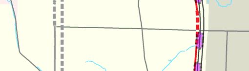
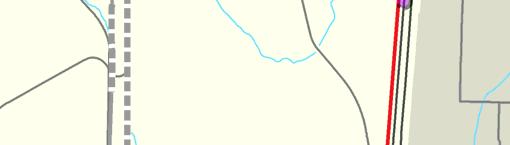
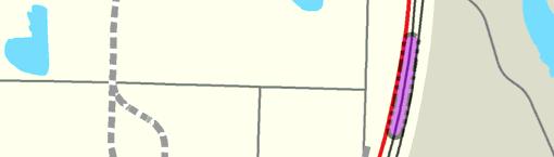
7 a d Midway Military Rd S S 288th St e S 252nd St b Camelot Square Mobile Home Park S 259th St c McSorley Wetland S 304th St Steel S 272nd St 272nd Station S 312th St f d Federal Way Transit Center S 317th St LEGED Eastern Alignment Western Alignment S 320th St Federal Way Transit Center Station a Station Section Key 23rd Ave S ot to Scale EXHIBIT J-2 Key Map for Comparison of Impacts to I-5 Corridor Federal Way Link Extension

 Less separation between roadway and structure Less space for future improvements Less space for right-of-way maintenance Midway Landfill I-5 Southbound I-5 orthbound orthbound S")

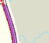
8 a Midway Landfill S 244th St to S 252nd St Proposed SR 509 S 216th St 24th Ave S Angle Station S 200th St 30th Ave S Existing Condition: o guardrail, slopes up to west, cleared grass area Approximate distance between edge of pavement and right-of-way limit is 190 feet for the section shown below S. Ken t D e s Moines Rd S 240th St 99 Midway Landfill a Eastern Alignment: Larger right-of-way remnant (3.4 acres) Less separation between roadway and structure Less space for future improvements Less space for right-of-way maintenance Midway Landfill I-5 Southbound I-5 orthbound orthbound S 260th St Wetland S 272nd St Western Alignment: Greater risk of encountering hazardous materials and groundwater Greater volume of waste removal 99 S 288th St ote: Landfill length 2,000 ft; 15 shafts Federal Way Transit Center S 320th St RIGHT-OF-WAY WEST WESTER ALIGMET EASTER ALIGMET PROPOSED I-5 SOUTHBOUD EDGE OF PAVEMET EXISTIG I-5 SOUTHBOUD EDGE OF PAVEMET PROPOSED I-5 ORTHBOUD EDGE OF PAVEMET EXISTIG I-5 ORTHBOUD EDGE OF PAVEMET MIDWAY LADFILL I-5 SOUTHBOUD EXISTIG GROUD (1969 TOPOGRAPHY) ESTIMATED BASE OF WASTE ot to Scale


 Minor opportunity to reduce visual impacts at 5 to 10 homes Less separation between roadway and structure Less space for future")

9 b Single-Family Residences S 252nd St to S 259th St S 216th St S. Ken t Proposed SR th Ave S D e s Moines Rd S 240th St S 260th St S 272nd St Angle Station S 200th St Wetland 30th Ave S 99 Midway Landfill b Existing Condition: Guardrail at S 259th St, slopes up to west, berm/bushes/mature trees Approximate distance between edge of pavement and right-of-way limit is 115 feet for the section shown below Eastern Alignment: Precludes opportunity for clear zone or other uses Larger right-of-way remnant (5.0 vs. 0.7 acres) Minor opportunity to reduce visual impacts at 5 to 10 homes Less separation between roadway and structure Less space for future improvements Less space for right-of-way maintenance S 254th St Residential Housing I-5 Southbound Southbound I-5 orthbound orthbound S 288th St Western Alignment: Visual impacts may be greater at some homes 99 Federal Way Transit Center S 320th St WESTER ALIGMET EASTER ALIGMET PROPOSED I-5 ORTHBOUD EDGE OF PAVEMET RIGHT-OF-WAY WEST PROPOSED I-5 SOUTHBOUD EDGE OF PAVEMET EXISTIG I-5 SOUTHBOUD EDGE OF PAVEMET EXISTIG I-5 ORTHBOUD EDGE OF PAVEMET EXISTIG RESIDETIAL HOUSIG I-5 SOUTHBOUD ot to Scale


 Avoids wetland impacts to McSorley Creek Wetlands Less separation between roadway and structure Less space for future improvements")

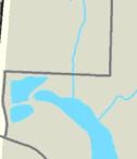
10 c McSorley Creek Wetlands S 259th St to S 272nd St S 216th St S. Ken t Proposed SR th Ave S D e s Moines Rd S 240th St S 260th St Angle Station S 200th St Wetland 30th Ave S 99 Midway Landfill c Existing Condition: Guardrail along north half, slopes down to west, mature trees, short detention basin clearing Approximate distance between edge of pavement and right-of-way limit is 190 feet for the section shown below Eastern Alignment: Larger right-of-way remnant (1.6 vs. 3.3 acres) Avoids wetland impacts to McSorley Creek Wetlands Less separation between roadway and structure Less space for future improvements Less space for right-of-way maintenance McSorley Creek Wetlands I-5 Southbound Southbound I-5 orthbound orthbound S 272nd St S 288th St Western Alignment: Some wetland impacts (<0.1 acre permanent) to McSorley Creek wetland 99 Federal Way Transit Center S 320th St WESTER ALIGMET EASTER ALIGMET PROPOSED I-5 SOUTHBOUD EDGE OF PAVEMET EXISTIG I-5 SOUTHBOUD EDGE OF PAVEMET PROPOSED I-5 ORTHBOUD EDGE OF PAVEMET EXISTIG I-5 ORTHBOUD EDGE OF PAVEMET RIGHT-OF-WAY WEST I-5 SOUTHBOUD WETLADS WETLADS ot to Scale


11 d Single-Family Residences S 272nd St to S 288th St S 216th St S. Ken t Proposed SR th Ave S D e s Moines Rd Angle Station S 200th St 30th Ave S Existing Condition: Guardrail at S 272nd St and S 288th St, slopes up to west along north half, bushes/mature trees, creek at S 288th St Approximate distance between edge of pavement and right-of-way limit is 165 feet for the section shown below I-5 Southbound Southbound I-5 orthbound S 240th St S 260th St 99 Wetland S 272nd St S 288th St 99 Midway Landfill d Eastern Alignment: Precludes opportunity for clear zone or other uses Larger right-of-way remnant (4.8 vs. 2.8 acres) Minor opportunity to reduce visual impacts at up to 10 homes Less separation between roadway and structure Less space for future improvements Less space for right-of-way maintenance Western Alignment: Visual impacts may be greater at some homes 29th Ave. S S Residential Housing Federal Way Transit Center S 320th St RIGHT-OF-WAY WEST EXISTIG RESIDETIAL HOUSIG WESTER ALIGMET EASTER ALIGMET PROPOSED I-5 SOUTHBOUD EDGE OF PAVEMET EXISTIG I-5 SOUTHBOUD EDGE OF PAVEMET EXISTIG I-5 ORTHBOUD EDGE OF PAVEMET I-5 SOUTHBOUD ot to Scale


12 e S 216th St S. Ken t Proposed SR th Ave S D e s Moines Rd S 240th St S 260th St Mobile Home Park and Single-Family Residences S 288th St to Military Road S 272nd St S 288th St Angle Station S 200th St Wetland 30th Ave S 99 Midway Landfill Existing Condition: oise wall/concrete barrier at mobile home park, slopes down to west, mature trees/creek west of noise wall Approximate distance between edge of pavement and right-of-way limit is 95 feet for the section shown below Eastern Alignment: Precludes opportunity for clear zone or other uses Larger right-of-way remnant (6.0 vs. 1.3 acres) More room for Bingaman Creek realignment Opportunity to reduce visual impacts at about 40 homes Less separation between roadway and structure Less space for future improvements Less space for right-of-way maintenance S 288th St. Bingaman Creek Residential Housing I-5 Southbound I-5 orthbound 99 Federal Way Transit Center e Western Alignment: More transit noise impacts, but could be mitigated Visual impacts may be greater at some homes S 320th St I-5 RIGHT-OF-WAY WEST WESTER ALIGMET EASTER ALIGMET EXISTIG SOUD WALL PROPOSED I-5 SOUTHBOUD EDGE OF PAVEMET EXISTIG I-5 SOUTHBOUD EDGE OF PAVEMET EXISTIG I-5 ORTHBOUD EDGE OF PAVEMET I-5 SOUTHBOUD EXISTIG RESIDETIAL HOUSIG BIGAMA CREEK 85 Varies ot to Scale


13 f Multi-Family Residences Military Road to S 317th St S 216th St S. Ken t Proposed SR th Ave S D e s Moines Rd S 240th St S 260th St S 272nd St Angle Station S 200th St Wetland 30th Ave S 99 Midway Landfill Existing Condition: Guardrail at Military Road and S 317th St, slopes up to west, berm bushes/mature trees Approximate distance between edge of pavement and right-of-way limit is 130 feet for the section shown below Eastern Alignment: Precludes opportunity for clear zone or other uses Larger right-of-way remnant (4.3 vs. 0.2 acres) Potential to increase visual impacts at about 10 homes Less separation between roadway and structure Less space for future improvements Less space for right-of-way maintenance Steel Maintenance Facility Residential Housing I-5 Southbound I-5 orthbound 99 S 288th St Western Alignment: Less visual impacts because of vegetation maintained between light rail and I-5 Federal Way Transit Center f S 320th St RIGHT-OF-WAY WEST WESTER ALIGMET EASTER ALIGMET EXISTIG I-5 SOUTHBOUD EDGE OF PAVEMET EXISTIG I-5 ORTHBOUD EDGE OF PAVEMET EXISTIG RESIDETIAL HOUSIG AD APARTMETS I-5 SOUTHBOUD ot to Scale
14 Appendix J Location of Preferred Alternative within I-5 Right-of-Way TABLE J-1 Comparison of Western and Eastern Alignment Configurations Resource Measure Western Alignment Eastern Alignment Transportation (Highway Safety) Transportation (Highway Safety) Property Acquisitions Length (feet) of clear zone removed by the FWLE without SR 509 Extension Length (feet) of clear zone removed by the FWLE with SR 509 Extension Acres of remnant right-of-way (limited or no use for future highway improvements) 0 2, , oise a umber of noise impacts 555 moderate, 74 severe 556 moderate, 67 severe Visual and Aesthetic Resources b Adjacent residences where visual quality would be lowered Ecosystems Acres of vegetation removal Acres of wetland impacts (McSorley Creek) <0.1 0 Acres of wetland buffer impacts (McSorley Creek) Total acres of wetland impacts a oise impacts would be mitigated. b Eastern alignment would minimize but not eliminate visual impacts at some locations. J.2.1 Clear Zone Impacts The American Association of State Highway and Transportation Officials (AASHTO) Roadside Design Guide (AASHTO, 2011) defines a clear roadside border area or clear zone as an unobstructed, relatively flat area beyond the edge of the traveled way (i.e., the general purpose lanes) that allows a driver to stop safely or regain control of a vehicle that leaves the traveled way. Geometric considerations define the extent of a clear zone, along with factors like terrain, speed limits, average traffic volumes, and fixed objects in the area. The clear zone for I-5 through the FWLE study area varies between 30 feet and 45 feet, measured from the outside lane line of the nearest lane (i.e., the shoulder is included within the clear zone) (WSDOT, 2015a). Where minimum clear zone conditions cannot be met, longitudinal barriers (guardrail, barrier, or walls) or impact attenuators can be provided to shield vehicles from roadside hazards. These hazards generally include: on-recoverable slopes (slopes steeper than 1 foot vertical to 4 feet horizontal) Trees Signs and signal supports Communications cabinets Power poles Other landscaping elements Street grade separation Table J-2 documents the southbound I-5 roadside conditions between S 211th Street and S 317th Street without and with the SR 509 Extension. It shows how the available clear zone would change with the FWLE western and eastern alignments. The table includes the lengths of existing Federal Way Link Extension J-12 Final EIS ovember 2016
15 Appendix J Location of Preferred Alternative within I-5 Right-of-Way barriers along I-5 as well as those proposed for the SR 509 Extension; the length of clear zone impact due to the FWLE alignments; and the resulting length of available clear zone along I-5. Exhibits J-3 and J-4 show where the western and eastern alignments would be located within a clear zone without and with the SR 509 Extension, respectively. TABLE J-2 Southbound I-5 o Build and Preferred Alternative Alignments Clear Zone Summary (between S 211th Street and S 317th Street) Without SR 509 Extension With SR 509 Extension Condition o Build Western Alignment Eastern Alignment o Build Western Alignment Eastern Alignment Length of Barrier Provided (in feet) a 11,500 11,500 (+0) 13,800 (+2,300) 20,900 20,900 (+0) 34,200 (+13,300) Length of Available Clear Zone (in feet) b 22,900 22,900 20,600 15,100 15,100 1,800 Total Segment Length (in feet) c 34,400 34,400 34,400 36,000 36,000 36,000 ote: Values shown in parentheses represent the additional length of the corridor where the FWLE would be located in an existing clear zone. Mitigation, such as barrier or guardrails, may be required with the project in these locations. a Represents areas where barriers currently exist and/or are proposed with the SR 509 Extension. These areas include shielding to protect highway infrastructure, tree stands, steep side slopes, or other landscaping elements, or are used to protect grade-separated crossings. b Represents areas where existing or future conditions meet the definition of a clear zone. c The clear zone distance with the SR 509 Extension is 1,600 feet longer because it accounts for the clear zone of the future SR 509 between SR 99 and I-5. Within the FWLE study area, an existing 22,900 feet of clear zone (approximately two-thirds of the total length) is present along I-5 southbound without the SR 509 Extension. The remaining one-third (11,500 feet) is currently shielded by guardrail or barrier. The shielded segments of the southbound I-5 roadside include 9,300 feet where WSDOT could potentially create a clear zone by alteration of, removal, or relocation of the roadside hazards previously described. Approximately 2,200 feet of barrier currently shields grade-separated streets (e.g., bridges) and a clear zone cannot be created. If built before the FWLE, the SR 509 Extension would provide 15,100 feet of clear zone along I-5 southbound. It proposes about 20,900 feet of longitudinal barrier, increasing the shielded segments of southbound I-5 by 9,400 feet compared to the scenario without the SR 509 Extension. Approximately 2,900 feet of the I-5 southbound roadside barrier would shield grade-separated streets (e.g., bridges) and a clear zone cannot be created. The potential for impacts on the I-5 southbound clear zone are described below for the light rail operation and construction conditions. Both of these conditions are evaluated with and without the SR 509 Extension to understand the potential cumulative impact of both projects. Federal Way Link Extension J-13 Final EIS ovember 2016


16 oines Creek SEATAC S 208th St S 216th St 24th Ave S UV 99 5 Military Rd S 35th Ave S COUTY mont Creek 16th Ave S DES MOIES S 272nd St Redondo Õ PR Heights P&R McSorley Creek Star P&R S Star Rd Õ PR ÕS KE Star UIC. KIG COUTY S 222nd St S 223nd St DES MOIES S 224th St 24th Ave S 30th Ave S Military Rd S Redondo Way S UV99 S 288th St Bingaman C KET Kent-Des M oines 20th Ave S S 240th St R d Massey Creek Highline College ÕS UIC. KIG COUTY UIC KIG COUT Midway Cree Dash Point Rd Redondo Creek Redondo Creek Bingaman Creek S 304th St Military Rd S FEDERAL WAY 5 34th Ave S 37th Ave S Mill C Steel McSorley Creek S 252nd St UV 99 Midway Landfill 5 Military Rd S Reith Rd Easter S 312th St 23rd Ave S Federal Way Transit Center Õ TC S 316th Pl S 317th St 28th Ave S UIC. KIG COUTY Dollo S 260th St S 259th Ln S 320th St ÕS 11th PlS S 324th St Federal Way/S 320th St P&R Õ PR Wa y S Legend Preferred Alternative At-Grade Other Alternatives At-Grade!! Existing Barrier City Boundary Elevated!!! Trench ÕS Station Elevated!!!Trench ÕS Station Eastern Alignment Impacts to the Clear Zone Street Stream Waterbody ± Data Sources: King County, Cities of Des Moines, Federal Way, Kent, SeaTac (2015). EXHIBIT J-3 I-5 Clear Zone Impacts Without SR Miles Federal Way Link Extension


17 Moines Creek SEATAC S 208th St S 216th St 24th Ave S UV 99 5 Military Rd S 35th Ave S UIC. KIG COUTY Ori Creek 16th Ave S DES MOIES S 272nd St Redondo Õ PR Heights P&R McSorley Creek Star P&R S Star Rd Õ PR ÕS KE Star UIC. KIG COUTY 16th Ave S Kent-Des M oines 20th Ave S S 240th St R d S 222nd St S 223nd St DES MOIES Massey Creek S 224th St 24th Ave S Highline College 30th Ave S ÕS Military Rd S UIC. KIG COUTY KET UI KIG COU Midway Cre Redondo Way S h Point Rd Redondo Creek UV 99 Redondo Creek S 288th St Bingaman Creek S 304th St Military Rd S FEDERAL WAY Steel 5 34th Ave S Bingaman Cre 37th Ave S Mill Cree McSorley Creek S 252nd St UV 99 Midway Landfill 5 Military Rd S Reith R aster S 312th St Federal Way Transit Center Õ TC S 316th Pl 23rd Ave S S 320th St ÕS S 317th St 28th Ave S UIC. KIG COUTY Dolloff S 260th St S 259th Ln S 324th St Federal Way/S 320th St P&R Õ PR Wa y S Legend Preferred Alternative Elevated At-Grade!!! Trench ÕS Station Other Alternatives Elevated At-Grade!! Trench ÕS Station!! SR 509 Barrier Eastern Alignment Impacts to the Clear Zone City Boundary Street Stream Waterbody ± Data Sources: King County, Cities of Des Moines, Federal Way, Kent, SeaTac (2015) Miles EXHIBIT J-4 I-5 Clear Zone Impacts With SR 509 Federal Way Link Extension
18 Appendix J Location of Preferred Alternative within I-5 Right-of-Way J Operation The impacts on the clear zone identified in Table J-2 and an assessment of potential changes in crash rates associated with the changes in the clear zone are described in this section. Without SR 509 Extension Without the SR 509 Extension, the western alignment would be at least 30 feet away from the existing edge of traveled way in all locations. It would be farther than 30 feet away in many locations. This alignment would not impact the existing clear zone along I-5 southbound. It would also preserve the potential for developing future clear zones along the I-5 southbound lanes. This condition would have no change in crash rates and therefore no impacts on the safety conditions along I-5. Without the SR 509 Extension, the eastern alignment would affect a short portion of the I-5 southbound clear zone. It would eliminate approximately 2,300 feet of the existing clear zone between S 284th Street and S 317th Street. Based on the methodologies described in the Highway Safety Manual (HSM; AASHTO, 2014), this reduction in clear zone could increase crashes by approximately one crash every 4 years on southbound I-5 between S 284th Street and S 317th Street. This section of I-5 southbound had approximately 380 crashes between 2007 and With SR 509 Extension Assuming the 2003 design of the SR 509 Extension is constructed before or concurrent with the FWLE, the western alignment would have no impact on the I-5 southbound mainline clear zone, while the eastern alignment would impact approximately 13,300 feet of it at locations dispersed between S 211th Street and S 317th Street. Based on HSM methodologies, the eastern alignment could increase crashes by approximately one crash every 2 years between S 211th Street and S 317th Street. This section of I-5 had approximately 480 crashes between 2007 and Highway Maintenance Activities WSDOT routinely performs maintenance activities along I-5. Maintenance activities generally include mowing, stormwater facility maintanence, spraying noxious weeds, accessing Intelligent Transportation System equipment and signs, and removing invasive plant species. These activities are generally performed within 10 feet of the edge of pavement. To perform them, WSDOT will typically park vehicles on the shoulder and provide advance warning signage to drivers. For maintanence access west of the guideway, such as servicing stormwater facilities and removing invasive weeds, the guideway would provide vertical clearances of at least 16.5 feet to allow access from I-5, or in some areas the right-of-way could be accessed from local streets. The FWLE could accommodate WSDOT s current maintenance activities in all areas of the corridor with each alignment and condition. The most constrained condition would be the eastern alignment with the SR 509 Extension. A minimum 10-foot buffer between the edge of pavement and the light rail guideway would still remain to allow maintenance activities. J Construction This section discusses construction vehicle access, the impacts on the existing and potential clear zone during the FWLE construction, and potential changes in crash rates associated with the changes in the Federal Way Link Extension J-16 Final EIS ovember 2016
19 Appendix J Location of Preferred Alternative within I-5 Right-of-Way clear zone. Heavy civil construction activity in any specific location is expected to range from 1 to 4 years. Appendix G, Construction Preliminary Impacts, Construction Staging Areas, and Haul Route Assumptions, of the Transportation Technical Report (Appendix G1 of the Final EIS) shows the proposed construction staging areas and truck haul routes. They would be the same for the western and eastern alignments, generally adjacent to where project construction would occur, with staging areas generally near the station areas. Access to the construction area would only be provided from arterials, local streets, and I-5 interchange areas. o direct access would be provided from the I-5 mainline for either the western or eastern alignment except for construction under the S 216th Street bridge and for removal of trees along the right-of-way. Both alignments would have the same potential access points to the construction area along I-5 in the vicinity of: S 208th Street S 216th Street S 224th Street 30th Avenue S (multiple locations) I-5 Kent-Des Moines Road southbound ramps S 252nd Street S 259th Place 26th Avenue S S 272nd Street Military Road (three locations) S 288th Street S 317th Street Without SR 509 Extension If the SR 509 Extension is not built before or concurrently with the FLWE, construction vehicle access would be provided via a temporary construction road adjacent to the guideway. This road would be at least 15 feet wide and may be up to 30 feet wide to allow for two-way construction vehicle traffic. With the western alignment, the road would be west of the alignment between S 204th Street and Kent-Des Moines Road and east of the alignment from Kent-Des Moines Road to S 317th Street. The construction road for the eastern alignment would be similar to the western alignment, except it would be west of the alignment between S 288th Street and S 317th Street to maximize the distance between the I-5 edge of pavement and the guideway. Both alignments would temporarily reduce the clear zone along most of I-5 southbound through the study area. A temporary construction barrier would be placed near the southbound I-5 edge of pavement for approximately 22,900 feet where barriers are not already present. Based on the HSM methodologies, this temporary barrier (between S 211th Street and S 317th Street) could result in an increase of up to four crashes per year for the western alignment, and up to five crashes per year for the eastern alignment during the construction period. With SR 509 Extension If the SR 509 Extension is built before or concurrently with the FWLE, construction vehicle access would be provided via a temporary construction road like the one described above. For the western alignment, it would be in the same location as described above. For the eastern alignment, it would always be west of the alignment (between S 204th Street and S 317th Street). Federal Way Link Extension J-17 Final EIS ovember 2016
20 Appendix J Location of Preferred Alternative within I-5 Right-of-Way As shown in Table J-2, the SR 509 Extension would reduce the clear zone along many sections of I-5 through the study area. Even so, both alignments would have temporary impacts on the I-5 southbound clear zone. About 1,000 feet of clear zone would remain during construction. A temporary construction barrier would be placed for approximately 15,100 feet near the southbound I-5 edge of pavement where barriers would not already be present. Based on the HSM methodologies, this could result in an increase of up to three crashes per year with the western alignment and up to four crashes per year with the eastern alignment during the construction period. J Clear Zone Mitigation During operations, the eastern alignment reduces the available clear zone with and without the SR 509 Extension, while the western alignment does not affect it with and without the SR 509 Extension. Where the project unavoidably reduces the available clear zone, Sound Transit would work with WSDOT and FHWA to identify appropriate mitigation, such as regrading to reestablish a clear zone or installing guardrail, barriers, and/or walls. Impacted stormwater facilities might be relocated or modified; access for maintenance activities would be provided. J.2.2 Property Acquisitions Sound Transit quantified the area in the I-5 right-of-way that would be left unusable or with restricted access on the west side of the light rail, as shown in Exhibit J-2 cross-sections a, c, and d. The eastern alignment would have more than twice as much remnant area as the western alignment (30.1 acres vs acres). Therefore, although both alignment configurations would accommodate all currently planned highway improvements, use of the I-5 right-of-way would reduce the area available for use by currently undefined and unplanned highway projects in the future. These projects could include highway expansion or other infrastructure improvements such as stormwater facilites or sound walls. Limiting the space available for future projects could also increase the costs of these projects during construction if more expensive construction methods are needed or a more expensive design is needed, such as an enclosed stormwater system instead of drainage ditches. J.2.3 oise and Vibration The detailed noise and vibration analysis for the Final EIS was performed for approximately 3,100 properties along the I-5 corridor. For this appendix, an eastern alignment 15 feet to the east of the Preferred Alternative was assumed and the final noise model was run for the places where this shift would be possible. Moving light rail farther away from noise-sensitive receivers, as shown in Exhibit J-2 cross-sections b, d, and e, would slightly reduce the number and severity of impacts. Doubling the distance between a receiver and a linear noise source (like a light rail guideway) typically reduces noise by 3 decibels (db), and even more when the topography provides shielding. For comparison, a 3-dB reduction in noise is barely perceptible to most people, a 5-dB change is clearly perceptible, and a 10-dB reduction is typically perceived by humans as a halving of the noise level. Mature trees and dense vegetation do not normally provide a noticeable noise reduction unless they are at least 100 feet thick, where a reduction of 3 db or more is possible. Front-line noise-sensitive receivers along I-5 (e.g., receivers directly adjacent to I-5 with no structural shielding) are generally between 60 and 125 feet from the Federal Way Link Extension J-18 Final EIS ovember 2016
21 Appendix J Location of Preferred Alternative within I-5 Right-of-Way western alignment, with some as close as 25 to 50 feet. Shifting the light rail 15 to 20 feet to the east would reduce noise levels by 1 to 3 db, depending on the location and topographical conditions between the light rail alignment and the homes. Most sites would have less than a 2-dB change. The western alignment would have 629 light-rail noise impacts, of which 555 are moderate and 74 are severe. Approximately 400 of these would occur north of Kent-Des Moines Road and would not vary between the western and eastern alignments evaluated in this appendix. Shifting 15 feet to the east would reduce seven severe impacts to moderate impacts and eliminate six moderate impacts. Sound Transit would mitigate impacts with sound walls or other noise mitigation measures. Mitigating to below impact criteria levels, however, does not mean that noise from the light rail guideway is eliminated altogether. The closer the light rail guideway is to homes, the greater the chances that residents would be able to hear the trains, even if the noise levels are below levels that constitute an impact. Vibration impacts would also occur with both alignments. The western alignment would have 56 impacts at the Camelot Square Mobile Home Park. All vibration impacts occur within 50 to 100 feet of the guideway. The eastern alignment would slightly reduce vibration impacts because of the increased distance from receivers to the guideway. J.2.4 Visual and Aesthetic Resources The mix of vegetation types varies in the undeveloped portion of the I-5 right-of-way. Closer to the existing travel lanes, the vegetation is a mix of mowed grass, shrubs, and trees. In general, mature trees and dense vegetation are most intact along the western boundaries of the right-of-way, adjacent to residences. The dense trees and vegetation provide a visual barrier or buffer between many residential areas and the freeway. Both alignments would remove similar amounts of this visual buffer between residences and I-5. The western alignment would reduce visual quality at about 160 residences between Kent-Des Moines Road and S 320th Street. There are some trees on either side of the alignment beyond the project permanent footprint that need to be assessed during final design to determine if they actually need to be removed. The assessment of reduced visual quality is conservative because it assumes all of these trees would be removed. Fewer residences might be impacted or the impact might be minimized if not all of these trees are removed. The eastern aligment could further reduce these impacts at up to 60 of these residences, depending on how many of these trees would actually need to be removed. There would also be about 10 additional impacts from tree removals that are limited to the eastern alignment. Both alignments would impact approximately 0.6 acre of designated state resource conservation areas at the western edge of the I-5 right-of-way in three areas south of S 272nd Street and south of S 312th Street. These properties were purchased by WSDOT to provide a visual buffer and have specific mitigation requirements described in the 2015 Roadside Policy Manual (WSDOT, 2015b). With the SR 509 Extension, visual impacts would be similar to the western alignment. Federal Way Link Extension J-19 Final EIS ovember 2016

22 J.2.5 Ecosystems Appendix J Location of Preferred Alternative within I-5 Right-of-Way The western alignment would have a less than 0.1-acre impact on the McSorley Creek wetland complex and 0.6-acre impact on the McSorley Creek wetland buffer. An eastern alignment would avoid impacts on this wetland and would reduce impacts on its buffer by less than 0.1 acre, as shown in Exhibit J-2 cross-section c. The eastern alignment would impact some wetlands not impacted by the western alignment, but would reduce overall wetland impacts from 0.7 acre to 0.6 acre. Both alignments would clear a similar area of vegetation, and therefore have similar impacts on ecosystem functions. The western alignment would permanently clear a little less forested upland habitat (about 37.7 acres vs acres). The eastern alignment would remove more upland habitat due to the additional distance it would travel to the east when entering and exiting the right-of-way to and from station areas and the additional distance between access roads and ancillary facilities and the shifted alignment (Exhibit J-5). While the eastern alignment would remove more forested upland habitat, the WSDOT Roadside Policy Manual would require less mitigation because of the types and size of trees impacted. Bingaman Creek extends along I-5 for approximately 1,000 feet north and south of S 288th Street. The existing WSDOT culverts under I-5 and S 288th Street in this area have been identified as fish passage barriers and may be replaced in the future by WSDOT. A western alignment EXHIBIT J-5 Emergency Access Road Comparison would realign approximately 1,000 feet of the creek under the guideway, impacting 0.2 acre of stream and 2.3 acres of stream buffer. If the alignment were shifted to the east, the stream would still be realigned around the columns, but with more room for realignment and for stream buffer restoration, particularly south of S 288th Street, and for the S 288th Street culvert replacement. J.2.6 Hazardous Materials Both alignment configurations would cross the Midway Landfill, requiring either removal of the waste for drilled shafts for an elevated guideway or compaction of the waste to support an at-grade guideway, as shown in Exhibit J-2 cross-section a. The depth of landfill waste under the western alignment is up to 65 feet deep, and under the eastern alignment it is approximately 40 feet. Shifting the alignment to the east would thus reduce the amount of waste removed. Drilled shafts (if used) would also be farther from groundwater in this area, reducing the potential for groundwater Federal Way Link Extension J-20 Final EIS ovember 2016

23 Appendix J Location of Preferred Alternative within I-5 Right-of-Way contamination (Exhibit J-6). Deeper shafts would also have higher capital costs and higher cost for waste removal. J.2.7 Social EXHIBIT J-6 Cross-section of Western and Eastern Alignments at Midway Landfill The western alignment would be closer to neighborhoods and therefore would have somewhat greater noise, vibration, and visual impacts as described above. According to U.S. Census data, some of these neighborhoods may include over 50 percent minority and up to 50 percent low-income populations (see Chapter 7, Environmental Justice, for additional demographic information). In addition to longterm impacts, the intensity of construction-related impacts in adjacent neighborhoods would be greater with the western alignment. An alignment farther east would in some places allow for more vegetative screening of the alignment and would decrease noise and vibration impacts on the residences. J.3 Conclusion FHWA and WSDOT recognize that site-specific constraints along the undeveloped right-of-way exist and may require flexibility to adjust the location of the light rail guideway to avoid or minimize potential impacts. For example, moving a guideway closer to the pavement from the edge of the rightof-way in some locations could reduce visual and noise impacts; it may avoid or reduce impacts on Federal Way Link Extension J-21 Final EIS ovember 2016
24 Appendix J Location of Preferred Alternative within I-5 Right-of-Way wetlands or other natural features at a specific location; it may resolve constructability issues or increased costs due to working in or around existing infrastructure in the area; and it may mitigate or avoid other potential impacts that would exist if the guideway were on the edge of the right-of-way. Sound Transit, the Federal Transit Administration (FTA), and the highway agencies will continue to work collectively to perform this balancing of potential impacts, costs, and benefits with effects on safety, future highway needs, and interstate maintenance and operations. Collectively, Sound Transit, FTA, and the highway agencies have identified at least two places in the I-5 alignment where this balancing of needs would be appropriate. One such location is where the light rail alignment approaches the Camelot Mobile Home Park south of S 288th Street (Exhibit J-2 crosssection d), where shifting the alignment east may be necessary to mitigate impacts on residents and, perhaps, Bingaman Creek. The other location is where the alignment crosses the Midway Landfill (Exhibit J-2 cross-section a). A more eastern alignment may be proposed if there are constructability risks with the western alignment in the vicinity of the Midway Landfill. Information collected from geotechnical borings during preliminary design have not indicated any constructability risks that make the eastern alignment preferable. Following the ROD, further design refinements will continue during final design and permitting. Consultation with the highway agencies, other interested agencies, and the public will also continue in tandem with the design advancement. J.4 References American Association of State Highway and Transportation Officials (AASHTO) Highway Safety Manual (HSM). American Association of State Highway and Transportation Officials (AASHTO) Roadside Design Guide. Federal Highway Administration (FHWA) Record of Decision for State Route 509: Corridor Completion/I-5/South Access Road Project, Southwest King County, Washington. Washington State Department of Transportation (WSDOT). 2015a. WSDOT Design Manual. M ovember Washington State Department of Transportation (WSDOT). 2015b. Roadside Policy Manual. M August Washington State Department of Transportation (WSDOT) I-5 - SR 509 Corridor Completion and Freight Improvement Project website. Federal Way Link Extension J-22 Final EIS ovember 2016
Letter FW030. General Transmission. Page 1
 Businesses Letter FW030 General Transmission Page 1 Response to Comment BU1-1 In developing alternatives, Sound Transit avoided and minimized impacts where possible, but some displacements would be unavoidable.
Chapter 1. Introduction. 1.1 Background
 Chapter 1 Introduction 1.1 Background The California Department of Transportation approved the Final Environmental Impact Report/ Finding of No Significant Impact (EIR/FONSI) for the I-5 HOV/Truck Lanes
Community Organizations
 Community Organizations Letter FW155 Associated Students of Highline College, Ruth Krizan Page 1 Response to Comment LC9-1 Sound Transit has a formal process for naming stations that occurs during final
Downtown Redmond Link Extension SEPA Addendum. Appendix G Environmental Justice. August Parametrix 719 2nd Avenue, Suite 200
 Downtown Redmond Link Extension SEPA Addendum Appendix G Environmental Justice August 2018 Prepared for Central Puget Sound Regional Transit Authority 401 S. Jackson Street Seattle, WA 98104 Prepared by
I 5 South Multimodal Corridor Study. Appendix B. Issue Statement
 I 5 South Multimodal Corridor Study Appendix B I-5 SOUTH MULTIMODAL CORRIDOR STUDY ISSUE STATEMENT JUNE 5, 2009 PROJECT DESCRIPTION The goal of the Interstate 5 (I-5) South Multimodal Corridor Study is
To the Federal Highway Administration, Federal Transit Administration, and Federal Railroad Administration:
 November 27, 2017 U.S. Department of Transportation Dockets Management Facility Room W12 140 1200 New Jersey Avenue SE Washington, DC 20590 Subject: Comments on Supplemental Notice of Proposed Rulemaking
PUGET SOUND GATEWAY PROGRAM PHASE 1 OF THE SR 509 COMPLETION PROJECT. Environmental Justice Technical Report
 PUGET SOUND GATEWAY PROGRAM PHASE 1 OF THE SR 509 COMPLETION PROJECT Environmental Justice Technical Report Prepared for Washington State Department of Transportation Prepared by PRR October 2017 Table
Case 2:08-cv MLCF-JCW Document 40 Filed 02/12/2009 Page 1 of 10 UNITED STATES DISTRICT COURT EASTERN DISTRICT OF LOUISIANA
 Case 2:08-cv-02159-MLCF-JCW Document 40 Filed 02/12/2009 Page 1 of 10 UNITED STATES DISTRICT COURT EASTERN DISTRICT OF LOUISIANA SAVE OUR WETLANDS * * Plaintiff, * Case No.: 08-2159 * v. * Sect. F Judge:
3.12 TRAFFIC AND CIRCULATION
 3.12 TRAFFIC AND CIRCULATION 3.12 Transportation and Circulation This section of the Draft EIR analyzes the existing transportation system in the area and addresses the potential transportation and circulation
O2-CD Zoning. B1-CD Zoning. O2-CD Zoning. RZ-1: Technical Data Sheet CHARLOTTE ETJ LIMITS 75' CLASS C RIGHT-IN / RIGHT-OUT, LEFT IN ACCESS POINT
 SITE PROPERTY LINE VICINITY MAP --Proposed Uses: On the portion of the Site zoned O-2(CD): a health institution (hospital), medical and general offices, and medical, dental and optical laboratory uses
ACCESS MANAGEMENT RULES AND FORMS
 ACCESS MANAGEMENT RULES AND FORMS 6/2/2016 Rules 14-96, 14-97, Procedures, and Statute 335.18 formatted for easy cites with forms Compiled and formatted June 2016. The administrative rules and forms formatted
RESOLUTION NO. R To Acquire Real Property Interests Required for the Federal Way Link Extension
 RESOLUTION NO. R2018-02 To Acquire Real Property Interests Required for the Federal Way Link Extension MEETING: DATE: TYPE OF ACTION: STAFF CONTACT: Capital Committee Board PROPOSED ACTION 01/11/2018 01/25/2018
HIGHWAYS DEVELOPMENT AND PROTECTION REGULATION
 Province of Alberta HIGHWAYS DEVELOPMENT AND PROTECTION ACT HIGHWAYS DEVELOPMENT AND PROTECTION REGULATION Alberta Regulation 326/2009 With amendments up to and including Alberta Regulation 179/2016 Office
2. PLAN ADMINISTRATION
 2. PLAN ADMINISTRATION 2.1 SECTION INTRODUCTION 2.1.1 This section gives an overview of District Plan administration. It discusses the sections of the Act that directly relate to the planning and resource
The following signs shall be permitted in all business and industrial districts:
 1405. Signs Authorized in Business and Industrial Districts. The following signs shall be permitted in all business and industrial districts: A. Temporary special event signs. Temporary special event signs,
CHAPTER House Bill No. 273
 CHAPTER 2006-249 House Bill No. 273 An act relating to outdoor advertising; amending s. 479.106, F.S.; revising provisions relating to the proximity of vegetation and beautification projects to outdoor
PLANNING COMMISSION STAFF REPORT
 PLANNING COMMISSION STAFF REPORT MEETING DATE: June 15, 2017 PROJECT NUMBER: C-17-023 REQUEST: An appeal of a conditional use permit to construct a new billboard and electronic message center sign on the
US-131/US-131BR Interchange Options Kalamazoo County
 US-131/US-131BR Interchange Options Kalamazoo County 1 PROBLEM 19 March 2015 The Kalamazoo County portion of US-131 was constructed in the early 1960s. The US-131 Business Route (BR) was constructed at
Only Establishment of a U.S. (Interstate) Route Action taken by SCOH: Extension of a U.S. (Interstate)Route
 Route Action taken by SCOH: Extension of a U.S. (Interstate)Route") American Association of State Highway and Transportation Officials An Application from the State Highway or Transportation Department of Colorado for: Elimination of a U.S. (Interstate) Route US 6 AASHTO
American Association of State Highway and Transportation Officials An Application from the State Highway or Transportation Department of Colorado for: Elimination of a U.S. (Interstate) Route US 6 AASHTO
OFFICE CONSOLIDATION FENCE BY-LAW BY-LAW NUMBER By-Law Number Date Passed Section Amended
 OFFICE CONSOLIDATION FENCE BY-LAW BY-LAW NUMBER 119-05 Passed by Council on November 28, 2005 Amendments: By-Law Number Date Passed Section Amended 55-07 April 23, 2007 Delete Private Swimming Pool Definition
CHAPTER 12 ROADS AND CONSTRUCTION AND MAINTENANCE OF DRIVEWAYS. Section 12.00, Private Access to Town Roads, consists of Sections through
 CHAPTER 12 ROADS AND CONSTRUCTION AND MAINTENANCE OF DRIVEWAYS SECTION 12.00 PRIVATE ACCESS TO TOWN ROADS Section 12.00, Private Access to Town Roads, consists of Sections 12.01 through 12.06. Section
STATE OF ILLINOIS COUNTY OF BUREAU GENERAL CONSTRUC TION HIGHWAY PERMIT. Whereas, I (we),, hereinafter termed the
,, hereinafter termed the") STATE OF ILLINOIS COUNTY OF BUREAU GENERAL CONSTRUC TION HIGHWAY PERMIT Whereas, I (we) (Name of Applicant) (Mailing Address),, hereinafter termed the (City) (State) Applicant, request permission and authority
STATE OF ILLINOIS COUNTY OF BUREAU GENERAL CONSTRUC TION HIGHWAY PERMIT Whereas, I (we) (Name of Applicant) (Mailing Address),, hereinafter termed the (City) (State) Applicant, request permission and authority
STREET OPENING AND CULVERT ORDINANCE
 STREET OPENING AND CULVERT ORDINANCE SECTION 1: PURPOSE The purpose of this Ordinance is to protect the safety of the traveling public, and to protect public infrastructure from undue adverse impacts by
CITY OF MEDFORD RIPARIAN CORRIDOR ORDINANCE. Adopted: June 1, 2000 by Ordinance #
 CITY OF MEDFORD RIPARIAN CORRIDOR ORDINANCE Adopted: June 1, 2000 by Ordinance # 1999-215 This new language is located in Article V - Site Development Standards, and replaces the Bear Creek (B-C) Overlay
Fences and Walls Handout Excerpts from MBMC
 Fences and Walls Handout Excerpts from MBMC MBMC Section 10.12.030 (P) Property Development Regulations: RS, RM, and RH districts The maximum height of a fence or wall shall be 6 feet in required side
WASHINGTON COUNTY HIGHWAY DEPARTMENT Policy & Procedure Number Adopted on January 1, 1999 Revised on December 2, 2014
 WASHINGTON COUNTY HIGHWAY DEPARTMENT Policy & Procedure Number 12.05 Adopted on January 1, 1999 Revised on December 2, 2014 (1) This policy and procedure is adopted to promulgate rules to regulate and
TOWN OF BELMONT NEW HAMPSHIRE DRIVEWAY REGULATIONS. Wording to be eliminated is crossed out Wording to be added is bold, italicized
 TOWN OF BELMONT NEW HAMPSHIRE DRIVEWAY REGULATIONS Wording to be eliminated is crossed out Wording to be added is bold, italicized ENACTED: MARCH 9, 1992 EDITION: TBD (Draft Date 6/7/18) TABLE OF CONTENTS
DISTRICT OF LAKE COUNTRY BYLAW 628, CONSOLIDATED VERSION (Includes amendment as of July 18, 2017)
") DISTRICT OF LAKE COUNTRY BYLAW 628, 2007 CONSOLIDATED VERSION (Includes amendment as of July 18, 2017) This is a consolidated copy to be used for convenience only. Users are asked to refer to the Highway
DISTRICT OF LAKE COUNTRY BYLAW 628, 2007 CONSOLIDATED VERSION (Includes amendment as of July 18, 2017) This is a consolidated copy to be used for convenience only. Users are asked to refer to the Highway
PLANNING COMMISSION MEETING MINUTES CITY OF GRANT
 PLANNING COMMISSION MEETING MINUTES CITY OF GRANT Present: Absent: John Rog, James Drost, Darren Taylor, Jeff Schafer, Dennis Kaup and Robert Tufty Jeff Giefer Staff Present: City Planner, Jennifer Haskamp;
Chapter CONDITIONAL USES
 Chapter 19.84 - CONDITIONAL USES 19.84.010 - Purpose. 19.84.020 - Conditional use permit required 19.84.030 - Application requirements Fee. 19.84.040 - Application review. 19.84.050 - Approval/denial authority.
SECTION 1 BACKGROUND. Chapter 1 Introduction
 SECTION 1 BACKGROUND Chapter 1 Introduction SECTION 1 BACKGROUND Chapter 1 Introduction 1.1 Overview The 1997 City of Thornton Comprehensive Plan identified the need to create Subarea Plans "to plan for
MEMORANDUM OF UNDERSTANDING BETWEEN the TAHOE REGIONAL PLANNING AGENCY and COUNTY/CITY
 MEMORANDUM OF UNDERSTANDING BETWEEN the TAHOE REGIONAL PLANNING AGENCY and COUNTY/CITY This Memorandum of Understanding (MOU) is entered between the Tahoe Regional Planning Agency (TRPA) and herein referred
PORT INDUSTRIAL ZONE - RULES
 Chapter 28 PORT INDUSTRIAL ZONE - RULES Introduction This chapter contains rules managing land uses in the. The boundaries of this zone are shown on the planning maps. In addition, the Port of Napier Planning
County of Sonoma Agenda Item Summary Report
 Revision No. 20151201-1 County of Sonoma Agenda Item Summary Report Agenda Item Number: 48 (This Section for use by Clerk of the Board Only.) Clerk of the Board 575 Administration Drive Santa Rosa, CA
STATE OF MINNESOTA PUBLIC UTILITIES COMMISSION ROUTE PERMIT FOR CONSTRUCTION OF A LARGE [PIPELINE TYPE] PIPELINE AND ASSOCIATED FACILITIES IN [COUNTY]
![STATE OF MINNESOTA PUBLIC UTILITIES COMMISSION ROUTE PERMIT FOR CONSTRUCTION OF A LARGE [PIPELINE TYPE] PIPELINE AND ASSOCIATED FACILITIES IN [COUNTY]](/thumbs/85/91731814.jpg "STATE OF MINNESOTA PUBLIC UTILITIES COMMISSION ROUTE PERMIT FOR CONSTRUCTION OF A LARGE [PIPELINE TYPE] PIPELINE AND ASSOCIATED FACILITIES IN [COUNTY]") STATE OF MINNESOTA PUBLIC UTILITIES COMMISSION ROUTE PERMIT FOR CONSTRUCTION OF A LARGE [PIPELINE TYPE] PIPELINE AND ASSOCIATED FACILITIES IN [COUNTY] ISSUED TO [PERMITTEE] PUC DOCKET NO. [Docket Number]
STATE OF MINNESOTA PUBLIC UTILITIES COMMISSION ROUTE PERMIT FOR CONSTRUCTION OF A LARGE [PIPELINE TYPE] PIPELINE AND ASSOCIATED FACILITIES IN [COUNTY] ISSUED TO [PERMITTEE] PUC DOCKET NO. [Docket Number]
C HAPTER 9: ENFORCEMENT AND VIOLATIONS. Enforcement Responsibilities
 C HAPTER 9: ENFORCEMENT AND VIOLATIONS The success of land use and development regulations is largely dependent on effective enforcement. As part of its Critical Area program, a local government is responsible
This Chapter may be cited as the "Skyline/Ridgeline Protection Regulations" and shall become effective April 5, 1999.
 Chapter 17.48 - Skyline/Ridgeline Protection Regulations 17.48.010 - Title and effective date. This Chapter may be cited as the "Skyline/Ridgeline Protection Regulations" and shall become effective April
Appendix A: Draft Billboard Ordinance
 Appendix A: Draft Billboard Ordinance THIS PAGE INTENTIONALLY LEFT BLANK DRAFT ORDINANCE NO. 11-18 AN ORDINANCE OF THE CITY COUNCIL OF THE CITY OF ORANGE ADOPTING MITIGATED NEGATIVE DECLARATION NO. 1860-18,
FOR SALE Bank Owned Former C-Store
 FOR SALE Bank Owned Former C-Store 29 Railroad Ave., Plainfield > Bank-owned former C-Store Retail (no gas allowed) on highly visible Route 14A > 3,000sf One story building on 0.29 acre with 70 Road frontage
Action Required in the Event of Abandonment of Cellular Tower Staff Review Proposals by the Applicant
 SHELBY COUNTY ZONING REGULATIONS ARTICLE XVIII TELECOMMUNICATION TOWERS Section 1800 Section 1801 Section 1802 Section 1803 Section 1804 Section 1805 Section 1806 Section 1807 Section 1808 Section 1809
LOCAL LAW NO.: OF 2016
 LOCAL LAWS & ORDINANCES\Chapter 179 Zoning Commercial Intensive Exit 18 Zoning District 4-18-16 LOCAL LAW NO.: OF 2016 A LOCAL LAW TO AMEND CHAPTER 179 ZONING OF QUEENSBURY TOWN CODE TO ESTABLISH COMMERCIAL
Plan and Zoning Commission City of Richmond Heights, Missouri
 Plan and Zoning Commission City of Richmond Heights, Missouri Regular Meeting 7:00 p.m., Thursday, September 17, 2015 City Council Chambers Richmond Heights City Hall Call to order: Roll Call: (Note name
The Planning and Zoning Commission met in a regular meeting with the following members present:
 THE BARTONVILLE PLANNING AND ZONING COMMISSION MEETING HELD ON THE 1 st DAY OF MARCH, 2017, AT BARTONVILLE TOWN HALL, 1941 E. JETER ROAD, BARTONVILLE, TX 76226, COUNTY OF DENTON, TEXAS AT 7:00 P.M. The
(Space for sketch on back - Submit detailed plan if available)
") CITY OF ANDERSON APPLICATION FOR ENCROACHMENT PERMIT MAIL TO: DEPARTMENT OF PUBLIC WORKS Engineering Department 1887 Howard Street Anderson, CA 96007 Date of Application: Commencement date: Completion
CITY OF ANDERSON APPLICATION FOR ENCROACHMENT PERMIT MAIL TO: DEPARTMENT OF PUBLIC WORKS Engineering Department 1887 Howard Street Anderson, CA 96007 Date of Application: Commencement date: Completion
AASHTO Use Only Establishment of a U.S. (Interstate) Route I-22 Action taken by SCOH: Extension of a U.S. (Interstate)Route
 Route I-22 Action taken by SCOH: Extension of a U.S. (Interstate)Route") American Association of State Highway and Transportation Officials An Application from the State Highway or Transportation Department of Mississippi for: Elimination of a U.S. (Interstate) Route AASHTO
American Association of State Highway and Transportation Officials An Application from the State Highway or Transportation Department of Mississippi for: Elimination of a U.S. (Interstate) Route AASHTO
TITLE 16 STREETS AND SIDEWALKS, ETC 1 CHAPTER 1 MISCELLANEOUS
 16-1 TITLE 16 STREETS AND SIDEWALKS, ETC 1 CHAPTER 1. MISCELLANEOUS. 2. SIGNS IN RIGHTS-OF-WAY. 3. LINES OF SIGHT AT INTERSECTIONS. CHAPTER 1 MISCELLANEOUS SECTION 16-101. Definitions. 16-102. Permit to
ORDINANCE NO. WHEREAS
 ORDINANCE NO. 13-16 AN ORDINANCE OF THE CITY OF DEBARY, FLORIDA, AMENDING THE CITY OF DEBARY LAND DEVELOPMENT CODE AMENDING CHAPTER 1 SECTION 1-3 CONCERNING HEDGE DEFINITION; CHAPTER 2 SECTION 2-5 CONCERNING
Beacon Falls Inland Wetlands & Watercourses Commission 10 Maple Avenue Beacon Falls, CT 06403
 Beacon Falls Inland Wetlands & Watercourses Commission 10 Maple Avenue Beacon Falls, CT 06403 BEACON FALLS INLAND WETLANDS & WATERCOURSES Public Hearing January 14, 2015 MINUTES (Subject to Revision) 1.
SR 147 MP 7 TO MP 14 TRAFFIC SAFETY EVALUATION CLARK COUNTY, NEVADA USING THE HIGHWAY SAFETY MANUAL AND THE INTERACTIVE HIGHWAY SAFETY DESIGN MODEL
 TRAFFIC SAFETY EVALUATION SR 147 MP 7 TO MP 14 CLARK COUNTY, NEVADA USING THE HIGHWAY SAFETY MANUAL AND THE INTERACTIVE HIGHWAY SAFETY DESIGN MODEL Prepared for: Nevada Department of Transportation Safety
CITY OF RUSTON. Inspection Department Fax: OFF-PREMISE SIGN PERMIT APPLICATION SITE PLAN MUST BE INCLUDED WITH APPLICATION
 Permit # CITY OF RUSTON Inspection Department 318-251-8640 Fax: 318-251-8650 OFF-PREMISE SIGN PERMIT APPLICATION SITE PLAN MUST BE INCLUDED WITH APPLICATION APPLICANT/PERSON ENTITLED TO POSSESSION OF SIGN:
ORDINANCE N LAND DEVELOPMENT CODE APALACHICOLA, FLORIDA
 ORDINANCE N0.91-7 LAND DEVELOPMENT CODE APALACHICOLA, FLORIDA AN ORDINANCE AMENDING ORDINANCE NUMBERS 86-3, 87-1 and 87-2; PROVIDING FOR ESTABLISHING ZONINGREGULATIONS AND LAND DEVELOPMENT CODE FOR THE
ORDINANCE NO * * * * * WHEREAS, the City Council of the City of Mont Belvieu, Texas, ( City ) is
 is") ORDINANCE NO. 2013- AN ORDINANCE AMENDING THE ZONING ORDINANCE OF THE CITY OF MONT BELVIEU, TEXAS, TO PROVIDE FOR CHANGES IN THE ZONING CODE RELATED TO LANDSCAPING; PROVIDING FOR SEVERABILITY; PROVIDING
ORDINANCE NO. 2013- AN ORDINANCE AMENDING THE ZONING ORDINANCE OF THE CITY OF MONT BELVIEU, TEXAS, TO PROVIDE FOR CHANGES IN THE ZONING CODE RELATED TO LANDSCAPING; PROVIDING FOR SEVERABILITY; PROVIDING
TITLE 18 - Signs and Related Regulations
 TITLE 18 - Signs and Related Regulations CHAPTER 18.01 GENERAL PROVISIONS 18.01.010 Title 18.01.020 Purpose 18.01.030 Compliance with Title Provisions 18.01.040 Interpretation 18.01.050 Relationship to
DEVELOPMENT REGULATORY AGREEMENT BY AND BETWEEN THE METROPOLITAN PARK DISTRICT FOR TACOMA AND THE CITY OF TACOMA
 DEVELOPMENT REGULATORY AGREEMENT BY AND BETWEEN THE METROPOLITAN PARK DISTRICT FOR TACOMA AND THE CITY OF TACOMA This DEVELOPMENT REGULATORY AGREEMENT (this Agreement ) is entered into this day of, 2015,
Chapter 9 DEVELOPMENT REVIEW PROCEDURES
 Chapter 9 DEVELOPMENT REVIEW PROCEDURES CHAPTER 9 DEVELOPMENT REVIEW PROCEDURES Section 901 Applicability Prior to undertaking any development or use of land in unincorporated Polk County, a development
(P) (A) (P) Jane Emerson, Board Coordinator, announced that there was a quorum of the committee present at roll call.
 (A) (P) Jane Emerson, Board Coordinator, announced that there was a quorum of the committee present at roll call.") SOUND TRANSIT CAPITAL COMMITTEE MEETING Summary Minutes CALL TO ORDER The meeting was called to order at 1:32 p.m. by Committee Chair Fred Butler, in the Ruth Fisher Boardroom, 401 South Jackson Street,
SOUND TRANSIT CAPITAL COMMITTEE MEETING Summary Minutes CALL TO ORDER The meeting was called to order at 1:32 p.m. by Committee Chair Fred Butler, in the Ruth Fisher Boardroom, 401 South Jackson Street,
AGENDA SAN DIEGUITO RIVER VALLEY REGIONAL OPEN SPACE PARK CITIZENS ADVISORY COMMITTEE. 10:30 a.m. to 12:15 p.m. Friday, December 2, 2011
 AGENDA SAN DIEGUITO RIVER VALLEY REGIONAL OPEN SPACE PARK CITIZENS ADVISORY COMMITTEE 10:30 a.m. to 12:15 p.m. Friday, December 2, 2011 Hope United Methodist Church 16550 Bernardo Heights Parkway (Corner
COMPREHENSIVE PLAN AMENDMENT STAFF REPORT AMENDMENT ROUND 12-2 BCC TRANSMITTAL PUBLIC HEARING, JULY 23, 2012
 Agenda Item: 3.C.1 COMPREHENSIVE PLAN AMENDMENT STAFF REPORT AMENDMENT ROUND 12-2 BCC TRANSMITTAL PUBLIC HEARING, JULY 23, 2012 I. General Data Project Name: Element: Congress Avenue Extension TIM & 2020
NEW HAMPSHIRE DRIVEWAY REGULATIONS
 TOWN OF BELMONT NEW HAMPSHIRE DRIVEWAY REGULATIONS ENACTED: MARCH 9, 1992 EDITION: OCTOBER 25, 2010 Town of Belmont SECTION 1. TABLE OF CONTENTS BASIS OF THESE REGULATIONS Page A. Authority 2 B. Separability
VEGETATION MANAGEMENT AT OUTDOOR ADVERTISING SIGNS RESTORE SIGN VISIBILITY POLICY (RSVP) REGULATIONS
 REGULATIONS") VEGETATION MANAGEMENT AT OUTDOOR ADVERTISING SIGNS RESTORE SIGN VISIBILITY POLICY (RSVP) REGULATIONS 1.0. Purpose The purpose of this policy is to establish procedures whereby sign owners may obtain permits
VEGETATION MANAGEMENT AT OUTDOOR ADVERTISING SIGNS RESTORE SIGN VISIBILITY POLICY (RSVP) REGULATIONS 1.0. Purpose The purpose of this policy is to establish procedures whereby sign owners may obtain permits
Environmental Justice Analysis for Support of NEPA Documentation SEH No. HENNC
 MEMORANDUM TO: FROM: Jim Grube, Hennepin County Scott Pedersen, MnDOT Samuel Turrentine, AICP DATE: RE: Environmental Justice Analysis for Support of NEPA Documentation SEH No. HENNC 34 4.00 The purpose
SUBCHAPTER 4B - EROSION AND SEDIMENT CONTROL
 _ SUBCHAPTER 4B - EROSION AND SEDIMENT CONTROL 15A NCAC 04B.0101 AUTHORITY 113A-64; Repealed Eff. November 1, 1984. 15A NCAC 04B.0102 15A NCAC 04B.0103 PURPOSE SCOPE Authority G.S. 113A-54(a)(b); Amended
MINUTES REGULAR MEETING CITY OF PLACERVILLE PLANNING COMMISSION TUESDAY, MAY 19, 2015, 6:00 P.M. TOWN HALL, 549 MAIN STREET, PLACERVILLE, CALIFORNIA
 MINUTES REGULAR MEETING CITY OF PLACERVILLE PLANNING COMMISSION TUESDAY, MAY 19, 2015, 6:00 P.M. TOWN HALL, 549 MAIN STREET, PLACERVILLE, CALIFORNIA 1. CALL TO ORDER The meeting was called to order at
APPENDIX B. Environmental Justice Evaluation
 Appendix B. Environmental Justice Evaluation 1 APPENDIX B. Environmental Justice Evaluation Introduction The U.S. Department of Transportation has issued a final order on Environmental Justice. This final
Proposed Amendments to General Code of Ordinances Marathon County Chapter 17 Zoning Code March 1, 2018
 Proposed Amendments to General Code of Ordinances Marathon County Chapter 17 Zoning Code March 1, 2018 Create: Section 17.204.545 METALLIC MINING A. Purpose and Intent. The purpose of this section is to
Part Two: Administrative Duties and Responsibilities, Procedures, Bylaw Amendments and Council Guidelines
 Part Two: Administrative Duties and Responsibilities, Procedures, Bylaw Amendments and Council Guidelines 2.1 Development Officer... 2 2.2 Permission Required for Development... 2 2.3 Method of Development
3620 PARK RD. MULTI-FAMILY REZONING PETITION No RZ-1 SITE DEVELOPMENT DATA VICINITY MAP NTS TECHNICAL DATA SHEET CHARLOTTE SITE PARK RD.
 SITE DEVELOPMENT DATA ACREAGE: ± 2.22 ACRES TAX PARCEL #S: 49-44-37 EXIING ZONING: R-4 PROPOSED ZONING: UR-2(CD) EXIING USES: SINGLE FAMILY RESIDENTIAL, VACANT PROPOSED USES: 20 SINGLE FAMILY ATTACHED
Three Bridges. PDXScholar
 Portland State University PDXScholar TREC Friday Seminar Series Transportation Research and Education Center (TREC) 11-20-2015 Three Bridges Robert Liberty Portland State University Let us know how access
ARTICLE 4 APPLICATION REVIEW PROCEDURES AND APPROVAL CRITERIA 3
 ARTICLE 4 APPLICATION REVIEW PROCEDURES AND APPROVAL CRITERIA 3 Chapter 4.1 General Review Procedures 4 4.1.010 Purpose and Applicability Error! Bookmark not defined. 4.1.020 Zoning Checklist 6 4.1.030
AGREEMENT FOR CONTROL OF OUTDOOR ADVERTISING INDIANA
 AGREEMENT FOR CONTROL OF OUTDOOR ADVERTISING Agreement between the State of Indiana and the United States of America concerning the Control of Outdoor Advertising in Areas Adjacent to the Interstate and
U.S. 301 (State Road 200)
") U.S. 301 (State Road 200) C.R. 227 to C.R. 233 Bradford County, FL Florida Department of Transportation FM #208001-1 Welcome to the Public Hearing Project Development and Environment (PD&E) Study Starke
U.S. 301 (State Road 200) C.R. 227 to C.R. 233 Bradford County, FL Florida Department of Transportation FM #208001-1 Welcome to the Public Hearing Project Development and Environment (PD&E) Study Starke
CITY OF SNOHOMISH Snohomish, Washington ORDINANCE 2325
 CITY OF SNOHOMISH Snohomish, Washington ORDINANCE 2325 AN ORDINANCE OF THE CITY OF SNOHOMISH, WASHINGTON, AMENDING THE CITY S DEVELOPMENT CODE BY AMENDING SMC SECTION 14.100.020 - DEFINITIONS; REPEALING
THE CORPORATION OF DELTA BYLAW NO A Bylaw for the protection of trees. Incorporating amendments pursuant to Bylaw 7613
 THE CORPORATION OF DELTA BYLAW NO. 7415 A Bylaw for the protection of trees Incorporating amendments pursuant to Bylaw 7613 December 12, 2016 Print December 19, 2016 THIS CONSOLIDATION IS FOR CONVENIENCE
Table of Contents. Executive Summary...1
 Table of Contents Executive Summary...1 1.0 Introduction...2 2.0 Strategic Environmental Assessment Methodology...3 2.1 Reference Databases... 3 2.2 Regulatory Framework... 3 2.3 SEA Methodology... 3 3.0
ORDINANCE NO. The Board of Supervisors of the County of Alameda ordains as follows: SECTION I
 ORDINANCE NO. AN ORDINANCE AMENDING CHAPTER 12.08 OF TITLE 12 OF THE GENERAL ORDINANCE CODE OF THE COUNTY OF ALAMEDA RELATING TO REGULATING WIRELESS FACILITY INSTALLATIONS IN THE PUBLIC RIGHT OF WAY The
ARTICLE 15 SPECIAL USE PERMITS
 ARTICLE 15 SPECIAL USE PERMITS SECTION 15.01 PURPOSE This Article is intended to provide regulations for Special Use Permits as authorized under New York State Town Law, Section 274-b, entitled "Approval
CITY OF COLORADO SPRINGS PLANNING COMMISSION RECORD-OF-DECISION
 October 21, 2010 Page 20 CITY OF COLORADO SPRINGS PLANNING COMMISSION RECORD-OF-DECISION NEW BUSINESS CALENDAR MEETING: OCTOBER 21, 2010 ITEM: 7.A, 7.B STAFF: LONNA THELEN FILE NO: CPC PUZ 09-00127, CPC
Accessory Buildings (Portion pulled from Town Code Updated 2015)
") Accessory Buildings (Portion pulled from Town Code Updated 2015) SECTION 1: TITLE 13 entitled Zoning, Chapter 2 entitled General Provisions, Section 13-2-10 entitled Building Location, Subsection 13.2.10(b)
Accessory Buildings (Portion pulled from Town Code Updated 2015) SECTION 1: TITLE 13 entitled Zoning, Chapter 2 entitled General Provisions, Section 13-2-10 entitled Building Location, Subsection 13.2.10(b)
Town of Ashland RIGHT-OF-WAY PERMIT APPLICATION
 Town of Ashland RIGHT-OF-WAY PERMIT APPLICATION APPLICATION is hereby made for permit as shown on the accompanying plan or sketch and as described below. Said activity(s) will be done under and in accordance
ARTICLE 7 WIRELESS TELECOMMUNICATIONS TOWERS AND FACILITIES
 ARTICLE 7 WIRELESS TELECOMMUNICATIONS TOWERS AND FACILITIES ARTICLE 7 WIRELESS TELECOMMUNICATIONS TOWERS AND FACILITIES 7.00 Purpose 7.04 Fees 7.01 Permitted Uses 7.05 Public Utility Exemption 7.02 Conditional
Freeway Deficiency Plan Final. Central Interstate 5 Corridor Study
 Freeway Deficiency Plan Final Central Interstate 5 Corridor Study December 2003 Prepared for: San Diego Association of Governments 401 B Street, Suite 800 San Diego, CA 92101 Prepared by: 1615 Murray Canyon
Soil Removal & Deposit Bylaw
 District of Metchosin Soil Removal & Deposit Bylaw No. 402 (2001) This bylaw has been consolidated for convenience only. Please contact staff to verify that the information contained in this document reflects
MEMORANDUM OF AGREEMENT For Devolution of Secondary Highway System Maintenance
 MEMORANDUM OF AGREEMENT For Devolution of Secondary Highway System Maintenance THIS MEMORANDUM OF AGREEMENT, made and executed in triplicate this day of, 200_, by and between the COUNTY of, Virginia, hereinafter
CHAPTER Committee Substitute for Committee Substitute for House Bill No. 687
 CHAPTER 2017-136 Committee Substitute for Committee Substitute for House Bill No. 687 An act relating to utilities; amending s. 337.401, F.S.; authorizing the Department of Transportation and certain local
ARTICLE 7 AMENDMENTS TO ORDINANCE
 ARTICLE 7 AMENDMENTS TO ORDINANCE 7.1 GENERAL AMENDMENTS 7-1 7.1.1 Authority 7-1 7.1.2 Proposal to Amend 7-1 7.1.3 Application and Fee 7-1 7.1.4 Referral for Advisory Opinion 7-1 7.1.5 Public Hearing Notice
I-5 Empire Project. 3 rd Annual. Community Open House. June 9, 2016
 I-5 Empire Project 3 rd Annual Community Open House June 9, 2016 Project Overview What: A series of improvements to I-5, local streets and the railroad tracks in Burbank between Magnolia Blvd. and Buena
TECHNICAL DATA SHEET - MUDD DEVELOPMENT AREA RZ1 SITE DEVELOPMENT DATA DEVELOPMENT AREA A DEVELOPMENT AREA B
 TECHNICAL DATA SHEET - MUDD AREA SITE DATA Acreage: ± 2.57 acres Tax Parcel #s: 155-012-09;- 10 & -12 Existing Zoning: O-2 Proposed Zoning: MUDD-O Existing Uses: Medical and professional offices uses.
ORDINANCE NO. 735 AN ORDINANCE OF THE CITY COUNCIL OF THE CITY OF HEDWIG
 ORDINANCE NO. 735 AN ORDINANCE OF THE CITY COUNCIL OF THE CITY OF HEDWIG VILLAGE, TEXAS AMENDING ARTICLE V, ZONING REGULATIONS, SECTION 509, PLANNED UNIT DEVELOPMENTS, OF THE HEDWIG VILLAGE PLANNING AND
TABLE OF CONTENTS 4.13 POPULATION AND HOUSING...
 TABLE OF CONTENTS 4.13 POPULATION AND HOUSING... 4.13-1 4.13.1 Introduction... 4.13-1 4.13.2 Regulatory Setting... 4.13-1 4.13.3 Existing Conditions... 4.13-2 4.13.4 Applicant Proposed Measures... 4.13-4
BEFORE THE DOUGLAS COUNTY HEARING EXAMINER I. FINDINGS OF FACT
 DOUGLASCOr~TY DEPARTMENT OF HEARING EXAMINER 140 19 th Street NW East Wenatchee, WAS 98802-4109 BEFORE THE DOUGLAS COUNTY HEARING EXAMINER I~ THE MATTER OF ) FINDINGS OF FACT, ) CONCLUSIO~S OF LA W, A~D
RIGHT OF WAY / STREET OPENING PERMIT
 Call for Inspections 253.983.7891 Provide 2 business days notice RIGHT OF WAY / STREET OPENING PERMIT Public Works Engineering Department 6000 Main Street SW Lakewood, WA 98499-5027 Ph.: 253.589.2489 /
: FENCE STANDARDS:
 10-1-33: FENCE STANDARDS: No person shall construct, erect, install, place, or replace any fence in the city not in compliance with the terms and conditions of this title and the international residential
2 May 14, 2014 Public Hearing
 2 May 14, 2014 Public Hearing APPLICANT & PROPERTY OWNER: CARMAX AUTO SUPERSTORES, INC. STAFF PLANNER: Kevin Kemp REQUEST: Modification of a Conditional Use Permit for Motor Vehicle Sales approved by the
TOWN OF CHESLEA ROAD DESIGN STANDARDS
 Section I: Statement of Purpose The purpose of this ordinance is to promote the health, safety, and public welfare of the residents of Chelsea by setting minimum construction standards for all streets
ORDINANCE 499 (AS AMENDED THROUGH ) AN ORDINANCE OF THE COUNTY OF RIVERSIDE AMENDING ORDINANCE NO
 AN ORDINANCE OF THE COUNTY OF RIVERSIDE AMENDING ORDINANCE NO") ORDINANCE 499 (AS AMENDED THROUGH 499.13) AN ORDINANCE OF THE COUNTY OF RIVERSIDE AMENDING ORDINANCE NO. 499 RELATING TO ENCROACHMENTS IN COUNTY HIGHWAYS The Board of Supervisors of the County of Riverside,
ORDINANCE 499 (AS AMENDED THROUGH 499.13) AN ORDINANCE OF THE COUNTY OF RIVERSIDE AMENDING ORDINANCE NO. 499 RELATING TO ENCROACHMENTS IN COUNTY HIGHWAYS The Board of Supervisors of the County of Riverside,
ARTICLE 7 AMENDMENTS TO ORDINANCE
 CHAPTER 240 UNIFIED DEVELOPMENT ORDINANCE CITY OF SARATOGA SPRINGS NY ARTICLE 7 AMENDMENTS TO ORDINANCE 7.1 GENERAL AMENDMENTS 7-1 7.1.1 Authority 7-1 7.1.2 Proposal to Amend 7-1 7.1.3 Application and
HIGH CAPACITY TRANSIT CORRIDOR STUDY LYNNWOOD TO EVERETT FINAL REPORT JULY 2014 FINAL
 HIGH CAPACITY TRANSIT CORRIDOR STDY LYNNWOOD TO EERETT JLY 2014 FINAL FINAL REPORT Final to Everett High Capacity Transit Study Final Report Table of Contents Summary... S-1 Study Approach... S-2 Developing
Site Provisions 8C-1. A. General. B. Number of Parking Spaces Required. Design Manual Chapter 8 - Parking Lots 8C - Site Provisions
 Design Manual Chapter 8 - Parking Lots 8C - Site Provisions 8C-1 Site Provisions A. General This section provides design criteria for site requirements such as number of parking spaces, landscaping, parking
ORDINANCE NO BE IT FURTHER ENACTED AND ORDAINED by the Mayor and City Council of Laurel, Maryland that
 ORDINANCE NO. 1932 AN ORDINANCE OF THE MAYOR AND CITY COUNCIL OF LAUREL, MD TO AMEND THE CITY OF LAUREL UNIFIED LAND DEVELOPMENT CODE; CHAPTER 20, LAND DEVELOPMENT AND SUBDIVISION, TO ADD ARTICLE VIA,
16 June 13, 2012 Public Hearing APPLICANT: ANTHONY & ALYIAH PETERKIN
 REQUEST: Conditional Use Permit (Truck & Trailer Rental) 16 June 13, 2012 Public Hearing APPLICANT: ANTHONY & ALYIAH PETERKIN PROPERTY OWNER: NEWTOWN BAKER SHOPPING CENTER LLC STAFF PLANNER: Faith Christie