Lake Panasoffkee. Restoration Council Report to the Legislature
|
|
|
- Alice Price
- 5 years ago
- Views:
Transcription


1 Lake Panasoffkee Restoration Council Report to the Legislature November 25, 2004
2 LAKE PANASOFFKEE RESTORATION COUNCIL S 2004 REPORT TO THE LEGISLATURE TABLE OF CONTENTS INTRODUCTION... 1 BACKGROUND... 1 Lake Panasoffkee... 1 Lake Panasoffkee Restoration Council... 2 Lake Panasoffkee Restoration Plan... 2 PROGRESS REPORT... 5 Funding and Project Costs... 5 Project Implementation... 5 RECOMMENDATIONS... 7
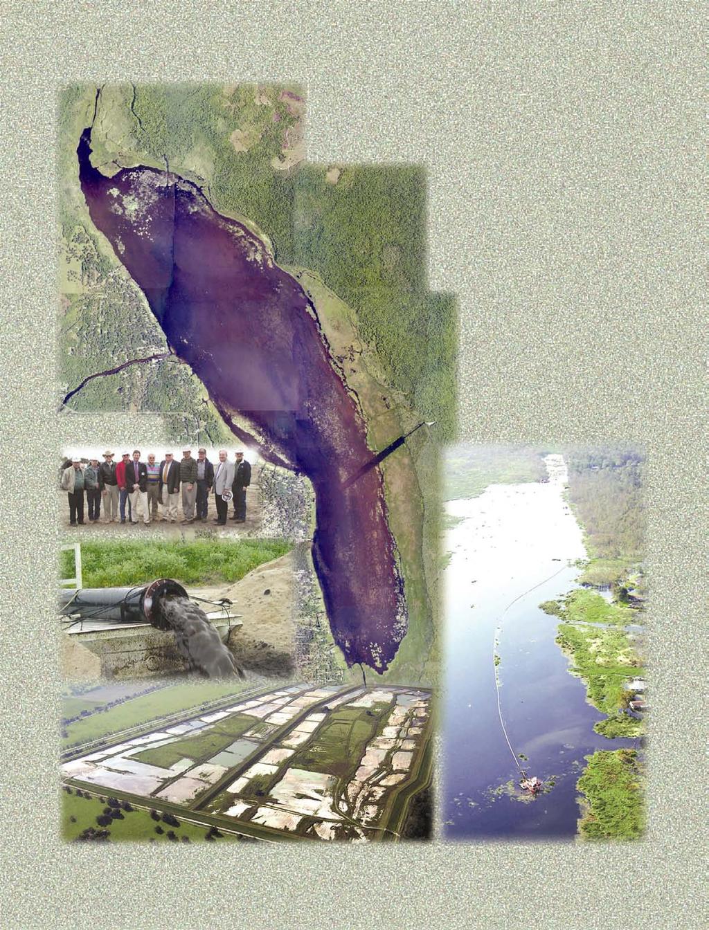
3 INTRODUCTION The Lake Panasoffkee Restoration Council (Council) is extremely pleased to submit its 2004 Report to the Legislature documenting the significant progress made towards implementation of the adopted restoration plan. The Council achieved all of its recommended milestones for 2004 which included the completion of the 450 acre upland spoil disposal facility in June 2004, and most importantly, the initiation of lake dredging which began in July The Council has continued its conservative pragmatic review and approval progress in the development of the final lake restoration plan, its implementation, and most importantly in the close oversight of expenditures. The total project cost based on actual incurred costs and contractual obligations is $25,051,227. We are pleased to report that funding commitments are now in place to fully fund the project. The funding partners and their contributions are as follows: State of Florida, $19,070,000, Federal Government, $1,098,000, Southwest Florida Water Management District, $3,014,884, and the Florida Fish and Wildlife Conservation Commission (FFWCC), $2,000,000. Without this much needed support, the Council could not have carried out the Legislative objective. Previous Reports to the Legislature, beginning in 1998, identified management issues, strategies and goals for Lake Panasoffkee, and the 2003 Report outlined the Council s final restoration plan for the lake. Since we are in the implementation phase of the project, the format of this year s Report to the Legislature differs from previous reports in that it does not include discussions on management issues and strategies, and the goals of the restoration plan. This year s Report focuses instead on implementation of the critical in-lake components of the Council s recommended restoration plan, the dredging of Steps 2 and 3. BACKGROUND Lake Panasoffkee Lake Panasoffkee in Sumter County is designated by the Florida Department of Environmental Protection (FDEP) as an Outstanding Florida Water and is the third largest of the approximately 1,800 lakes in west central Florida. Additionally, the lake is included on the District s Surface Water Improvement and Management (SWIM) Priority Water Body List. Lake Panasoffkee has a national reputation, especially for its redear sunfish fishery, and this makes the lake an important contributor to the local and regional economy. Although, fishing remains popular at Panasoffkee, the lake s future as an important recreational resource is threatened. The fisheries there have declined considerably during the last 30 to 40 years. In the mid-1950s, when the lake s fishery was first being studied, at least 15 fish camps operated there. In 1998 when the Council s first Report to the Legislature was submitted only three remained. Today there are five operating fish camps on the lake. 1
4 Lake Panasoffkee Restoration Council In an effort to protect and restore the environmental and economic importance of Lake Panasoffkee, the 1998 Florida Legislature created the Lake Panasoffkee Restoration Council within the Southwest Florida Water Management District (District). The enabling legislation (Chapter 98-69, Laws of Florida) established the membership and outlined the responsibilities of the Council and the Advisory Group. Through the enabling legislation, the Legislature directed the Council to develop a restoration plan for Lake Panasoffkee. During its first year, the Council and Advisory Group prioritized the management issues and developed strategies for restoring the lake. The Council also recommended additional studies to evaluate the lake's fishery and identified additional information needed to implement the restoration plan. The culmination of this effort was discussed in detail in the first Lake Panasoffkee Restoration Council Report to the Legislature, dated November 25, Pursuant to its Legislative directive, the Council has reported to the Legislature every year since 1998 to provide progress reports and recommendations for the next fiscal year. Lake Panasoffkee Restoration Plan The final restoration plan documented in the 2003 Report to the Legislature is comprised of four distinct steps. Step 1 of the plan, the Coleman Landing Pilot Project, was completed in December The primary focus now is on the implementation of Steps 2 and 3 of the restoration plan which constitutes the full-scale in-lake restoration effort, and consists of the dredging of approximately 1,977 acres of lake bottom. Steps 2 and 3 are crucial to achieving the Council's goals to restore fisheries habitat and historic shoreline conditions, and improve navigation. The four steps comprising the Council s final restoration plan are described below in order of priority. 2
5 Step 1 Coleman Landing Pilot Project: (Completed in December 2000) The goals of this step were threefold. First and foremost, this pilot dredging project provided information critical to the design, permitting, and dredging of Steps 2 and 3 by confirming settling rates needed to size the upland spoil disposal area for Steps 2 and 3, and by demonstrating that discharge water would meet state water quality standards. Step 1 also confirmed that submerged aquatic vegetation (SAV) would re-colonize in dredged areas, and provided an expected rate of re-colonization, both of which were key issues in the environmental permitting of Steps 2 and 3. The third goal was to restore public access and navigation by re-establishing a navigable channel from the existing Coleman's Landing boat ramp into the lake. Step 2 Dredge to Hard Bottom: The goal of this step is to dredge approximately 915 acres of lake bottom (3,442,071 cubic yards of sediment) to restore fisheries habitat, specifically the historic fish spawning areas in the vicinity of Grassy and Shell Points, where the desired hard bottom (sand/shell) for fish spawning has been covered by unconsolidated sediments. Dredging of this step will also restore historic shoreline conditions along the eastern and western shores to provide improved fisheries, navigation and recreational benefits. Step 3 Dredge East-side Emergent Vegetation: The goal of this step is to dredge approximately 1,062 acres of lake bottom (4,767,644 cubic yards of sediment) along the eastern and southern shores and in the creeks at the southern end of the lake to restore fisheries habitat and historic shoreline conditions. Step 4 Canals: The goal of this step is to improve lake access from the forty one residential canals located along the lake s western shoreline by the maintenance dredging of sediment and vegetation in the canals. Sumter County has taken the lead in implementing this step. In 2001, at the request of Sumter County, the Council authorized the District (as custodian for the restoration funds) to release $200,000 in State appropriated funds to the county for the implementation of Step 4. The dredging boundaries of the in-lake steps of the restoration plan are shown in Figure 2 on the following page. 3

6 41 residential canals along western shoreline Step 4: Canals 4
7 PROGRESS REPORT Funding and Project Costs Updated costs for the four steps of the Council s recommended restoration plan are shown in Table 1. The costs shown for each step include design, permitting, construction management, SAV monitoring, and construction/dredging costs. Inkind costs incurred by the District, FFWCC and the FDEP for water quality and fisheries monitoring and project management are not included. Table 1 - Restoration steps showing acreage, sediment volume and costs Area Volume Restoration Step Acres Cu. Yards Total Costs Step 1 - Coleman Landing Pilot Project ,035 $756,767 Step 2 - Dredge to Hard Bottom ,442,071 $12,098,254 Step 3 - Dredge East-side Emergent Zone 2 1,062 4,767,664 $11,996,206 Step 4 - Canals 3 128,444 $200,000 Total $25,051,227 Notes: 1. Step 1 was completed in December Costs include reclamation costs for the spoil disposal site. 2. Costs for design, permitting, construction management, SAV monitoring, mobilization, contingency and site work have been pro-rated between Steps 2 and 3. Costs shown are based on actual costs and bid amounts, and have been refined since the 2003 Report. 3. The dredging of the canals is being undertaken by Sumter County. The amount shown in the total cost column, $200,000, only represents the amount committed by the Council in Sumter County is providing additional funds and resources. Additionally, the 128,444 cubic yard figure is the estimated volume of material to be removed from the canals, but should not be used as a comparative cost per cubic yard against the $200,000 shown to the right. Project Implementation Since award of the dredging contract for Steps 2 and 3 in August 2003, significant construction activity has taken place. The status of construction for the dredging of Steps 2 and 3 and related site work, along with the status of other recommendations in the Council s the 2003 Report to the Legislature are reported below. Spoil Disposal Area: The District issued the notice to proceed to the contractor on December 8, 2003 to construct the 450 acre upland confined disposal facility to contain the sediments to be dredged from Steps 2 and 3. This work also included the placement of the dredge pipeline from the lake to the disposal facility. The disposal facility was completed and accepted by the District on June 2, The completed facility was subsequently certified to the FDEP on June 30, 2004 in accordance with the specific conditions of the Environmental Resource Permit issued for Steps 2 and 3. The total cost of the confined disposal facility was $6,947,803. It is worthy to note that the spoil disposal area 5
8 was completed within budget and ahead of schedule. Figures 3 and 4 provide aerial photographs of the completed disposal facility. Dredging of Steps 2 and 3: The District issued the notice to proceed for the dredging of Step 2 on July 2, The cost of the dredging of Step 2 is $11,361,866. Step 2 has a 500 calendar day construction period making the projected completion date November 14, Upon the completion of Step 2, the District will issue the notice to proceed with Step 3, which has a cost of $11,266,029. Step 3 will have an 800 calendar construction period making its projected completion date January 3, Figure 5 provides an aerial view of the disposal area showing the dredge pipeline discharging sediments into settling cell No. 2. Figure 6 provides an aerial view of the dredge in the lake dredging Step 2 near the southern end of the lake. Monitoring of submerged aquatic vegetation (SAV): The Council's first Report to the Legislature, dated November 1998, acknowledged the importance of existing healthy SAV in Lake Panasoffkee. Baseline SAV mapping for the entire lake was completed in December Since the baseline mapping effort, the District has implemented an annual SAV monitoring program to monitor the areal coverage. The annual aerial mapping and monitoring of the SAV coverage could not be performed in 2003 due to poor water clarity conditions resulting from heavy rainfall that began in the summer of 2002 and extended through the summer of However, water clarity in the lake improved this past year to the point where the District was able to resume mapping in April The updated mapping showed the areal coverage of SAV to be at 70 percent. Continue Fish Population study using electrofishing methods: The Commission continued its fish population studies using electrofishing methods. Data collected indicate increases in largemouth bass densities since the 2001 data collection effort. It is believed that this increase may be due to rising water levels that have caused a decline in deep SAV beds. This would lead fish to congregate in near shore areas making them more susceptible to capture using electrofishing methods. An increase in panfish densities was also noted, though less significant than largemouth bass increase. 6
9 RECOMMENDATIONS The Council's recommendations for the upcoming year are listed below. Complete the dredging of Step 2 by the scheduled date of November 14, Commence the dredging of Step 3. Continue to map and monitor SAV trends. Submit semi-annual status reports to the FDEP as required under the Environmental Resource Permit issued for Steps 2 and 3. Request re-verification letter from the U. S. Army Corps of Engineers for the Nationwide 27 and Nationwide 29 permits issued for Steps 2 and 3. 7

10 Settling Cell 1 To lake Settling Cell 2 Polishing Cell Interstate 75 Disposal Facility Facts Size: 450 acres Embankment Height: 20 ft. Embankment Volume: 1.2 million C. Y. Cost: $6,947,803 Lake Panasoffkee Restoration Project Upland Confined Disposal Facility for Steps 2 and 3 (Oblique View Looking Northwest) Figure 3 8

11 Settling Cell 1 Settling Cell 2 Interstate 75 Polishing Cell Lake Panasoffkee Restoration Project Upland Confined Disposal Facility for Steps 2 and 3 (Orthogonal View) Figure 9 4

12 Aerial View of the Dredge Discharge into the Confined Disposal Facility Figure 5 10

13 Confined Disposal Facility (in the distance) Aerial View of the Dredge In-lake Dredging Step 2 Near South End of Lake Panasoffkee Figure 6 11
U.S. ARMY CORPS OF ENGINEERS REGULATORY DIVISION WILMINGTON DISTRICT
 U.S. ARMY CORPS OF ENGINEERS REGULATORY DIVISION WILMINGTON DISTRICT January 10, 2016 Regulatory Offices w/in The Mid-Atlantic Philadelphia District: (215) 656-6725 Baltimore District: (410) 962-3670 Norfolk
1.0 Purpose To provide procedural direction for the implementation of Policy PL Work Permits Section 14 Public Lands Act.
 Ministry of Natural Resources Subject Work Permits Section 14 Public Lands Act Compiled by - Branch Natural Heritage, Lands & Protected Spaces Section Lands and Non-Renewable Resources Procedure PL 3.03.04
CHAPTER 20B. CD DISTRICT (COASTAL DEVELOPMENT DISTRICT)
") CHAPTER 20B. CD DISTRICT (COASTAL DEVELOPMENT DISTRICT) SECTION 6328. ESTABLISHMENT AND PURPOSE OF COASTAL DEVELOPMENT DISTRICT. There is hereby established a Coastal Development ( CD ) District for the
CHAPTER 20B. CD DISTRICT (COASTAL DEVELOPMENT DISTRICT) SECTION 6328. ESTABLISHMENT AND PURPOSE OF COASTAL DEVELOPMENT DISTRICT. There is hereby established a Coastal Development ( CD ) District for the
U.S ARMY CORPS OF ENGINEERS, GALVESTON DISTRICT REGIONAL AND PROGRAMMATIC GENERAL PERMIT SWG
 U.S ARMY CORPS OF ENGINEERS, GALVESTON DISTRICT REGIONAL AND PROGRAMMATIC GENERAL PERMIT SWG-2007-00720 Permittee: General Public Issuing Office: U.S. Army Corps of Engineers. Galveston District Project
MINUTES OF THE FLORIDA INLAND NAVIGATION DISTRICT
 MINUTES OF THE FLORIDA INLAND NAVIGATION DISTRICT Board of Commissioners Meeting 9:00 a.m., Friday, March 16, 2018 Four Points by Sheraton 11 1 st Street North Jacksonville Beach, (Duval County) Florida
Consolidation of State and Federal Wetland Permitting Programs Implementation of House Bill 759 (Chapter , Laws of Florida) Florida
 Florida") Consolidation of State and Federal Wetland Permitting Programs Implementation of House Bill 759 (Chapter 2005-273, Laws of Florida) Florida Department of Environmental Protection September 30, 2005 Consolidation
Consolidation of State and Federal Wetland Permitting Programs Implementation of House Bill 759 (Chapter 2005-273, Laws of Florida) Florida Department of Environmental Protection September 30, 2005 Consolidation
CITY OF MEDFORD RIPARIAN CORRIDOR ORDINANCE. Adopted: June 1, 2000 by Ordinance #
 CITY OF MEDFORD RIPARIAN CORRIDOR ORDINANCE Adopted: June 1, 2000 by Ordinance # 1999-215 This new language is located in Article V - Site Development Standards, and replaces the Bear Creek (B-C) Overlay
CHAPTER Committee Substitute for Senate Bill No. 2260
 CHAPTER 2003-265 Committee Substitute for Senate Bill No. 2260 An act relating to water policy; repealing s. 373.0693(11), F.S.; deleting a provision requiring legislative approval to abolish or combine
Legislative Council, State of Michigan Courtesy of
 NATURAL RESOURCES AND ENVIRONMENTAL PROTECTION ACT (EXCERPT) Act 451 of 1994 PART 301 INLAND LAKES AND STREAMS 324.30101 Definitions. Sec. 30101. As used in this part: (a) "Bottomland" means the land area
ST. AUGUSTINE PORT, WATERWAY & BEACH DISTRICT MINUTES OF REGULAR MEETING. Tuesday, May 21, 2013
 ST. AUGUSTINE PORT, WATERWAY & BEACH DISTRICT MINUTES OF REGULAR MEETING Tuesday, May 21, 2013 The regular meeting of the St. Augustine Port, Waterway & Beach District was held at the St. Augustine Beach
REGULATING BOATING ON LOCAL WATERS. The State Marine Board s Procedures for Adopting, Amending and Repealing Rules
 REGULATING BOATING ON LOCAL WATERS The State Marine Board s Procedures for Adopting, Amending and Repealing Rules Recreational boaters in Oregon are subject to a variety of laws, regulations and rules.
The Jackson River Fishery and Public Access Litigation. Summary
 The Jackson River Fishery and Public Access Litigation Summary The Jackson River tailwater, which is composed of the stretch of river extending downstream from Lake Moomaw to Covington, is recognized as
Appendix L Authorization
 Appendix L Authorization Intentionally Left Blank Upper Mississippi River Restoration Authorization (Formerly referred to as Environmental Management Program) Section 1103 of the Water Resources Development
CHAPTER 26 SHORELAND-WETLAND ZONING ORDINANCE For the City of Wisconsin Dells, Wisconsin Table of Contents
 Section CHAPTER 26 SHORELAND-WETLAND ZONING ORDINANCE For the City of Wisconsin Dells, Wisconsin Table of Contents Page 1.0 STATUTORY AUTHORIZATION, FINDINGS OF FACT, STATEMENT OF PURPOSE AND TITLE 1 1.1
BEFORE THE BOARD OF COUNTY COMMISSIONERS FOR JOSEPHINE COUNTY
 BEFORE THE BOARD OF COUNTY COMMISSIONERS FOR JOSEPHINE COUNTY Ordinance No. 2006 001 AN ORDINANCE AMENDING THE JOSEPHINE COUNTY RURAL LAND DEVELOPMENT CODE (ORD. 94-4) TO ADD AND REPLACE DEFINITIONS CONTAINED
33 CFR PART 329 DEFINITION OF NAVIGABLE WATERS OF THE UNITED STATES. Authority: 33 U.S.C. 401 et seq.
 33 CFR PART 329 DEFINITION OF NAVIGABLE WATERS OF THE UNITED STATES Authority: 33 U.S.C. 401 et seq. Source: 51 FR 41251, Nov. 13, 1986, unless otherwise noted. 329.1 Purpose. 329.2 Applicability. 329.3
SURFACE MINING AND RECLAMATION ACT OF 1975
 SURFACE MINING AND RECLAMATION ACT OF 1975 As amended by: Senate Bill 1300, Nejedly - 1980 Statutes Assembly Bill 110, Areias - 1984 Statutes Senate Bill 593, Royce - 1985 Statutes Senate Bill 1261, Seymour
GENERAL ASSEMBLY OF NORTH CAROLINA SESSION 2017 SENATE BILL 410 RATIFIED BILL
 GENERAL ASSEMBLY OF NORTH CAROLINA SESSION 2017 SENATE BILL 410 RATIFIED BILL AN ACT TO ESTABLISH A PROGRAM FOR THE LEASING OF PUBLIC BOTTOM AND SUPERJACENT WATER COLUMN FOR MARINE AQUACULTURE, TO REQUIRE
J 0 I NT PUBLIC NOTICE
 J 0 I NT PUBLIC NOTICE CHARLESTON DISTRICT, CORPS OF ENGINEERS 69A Hagood Avenue Charleston, South Carolina 29403-5107 and THE S.C. DEPARTMENT OF HEALTH AND ENVIRONMENTAL CONTROL Office of Environmental
THE GULF INTRACOASTAL WATERWAY IN TEXAS
 THE GULF INTRACOASTAL WATERWAY IN TEXAS PRESENTED IN RESPONSE TO THE TRANSPORTATION CODE, CHAPTER 51 AND SUBMITTED TO THE SEVENTY-EIGHTH SESSION OF THE TEXAS LEGISLATURE PREPARED BY TRANSPORTATION PLANNING
CHAPTER 29 WETLAND ZONING
 CHAPTER 29 WETLAND ZONING 29.00 STATUTORY AUTHORIZATION, FINDINGS OF FACT, STATEMENT OF PURPOSE AND TITLE... 2 (1) Statutory Authorization... 2 (2) Findings of Fact and Purpose... 2 29.02 GENERAL PROVISIONS...
ST. AUGUSTINE PORT, WATERWAY & BEACH DISTRICT MINUTES OF REGULAR MEETING. Tuesday, February 19, 2013
 ST. AUGUSTINE PORT, WATERWAY & BEACH DISTRICT MINUTES OF REGULAR MEETING Tuesday, February 19, 2013 The regular meeting of the St. Augustine Port, Waterway & Beach District was held at the St. Augustine
NOTICE ANNOUNCING RE-ISSUANCE OF A REGIONAL GENERAL PERMIT
 Public Notice US Army Corps of Engineers Louisville District Public Notice No. Date: Expiration Date: RGP No. 003 9 Jul 08 9 Jul 13 Please address all comments and inquiries to: U.S. Army Corps of Engineers,
33 USC 652. NB: This unofficial compilation of the U.S. Code is current as of Jan. 4, 2012 (see
 TITLE 33 - NAVIGATION AND NAVIGABLE WATERS CHAPTER 13 - MISSISSIPPI RIVER COMMISSION 652. Upper Mississippi River Management (a) Short title; Congressional declaration of intent (1) This section may be
WHEREAS, the Board of Commissioners adopted the restated Pasco County Land Development Code on October 18, 2011 by Ord. No.
 BOARD OF COUNTY COMMISSIONERS ORDINANCE NO. AN ORDINANCE BY THE PASCO COUNTY BOARD OF COUNTY COMMISSIONERS AMENDING THE PASCO COUNTY LAND DEVELOPMENT CODE; SECTION 1001.4 VISIBILITY; 1001.5 NAVIGABILITY
Project Title: Status and Assessment of Northern Snakeheads, Channa argus, and Native Fishes in the Big Piney Watershed Following Operation Mongoose
 Project Title: Status and Assessment of Northern Snakeheads, Channa argus, and Native Fishes in the Big Piney Watershed Following Operation Mongoose Project Summary: During spring of 2009, rotenone was
ADDITIONAL MATERIAL Regular Meeting SEPTEMBER 25, 2018
 ITEM #51 Exhibit 1 Project Cooperation Agreement ADDITIONAL MATERIAL Regular Meeting SEPTEMBER 25, 2018 SUBMITTED AT THE REQUEST OF ENVIRONMENTAL PROTECTION AND GROWTH MANAGEMENT DEPARTMENT Page 1 of 9
COLUMBIA RIVER TREATY & WOTUS RULES UPDATES. Henry s Fork Watershed Council Jerry R. Rigby Rigby, Andrus & Rigby Law, PLLC
 COLUMBIA RIVER TREATY & WOTUS RULES UPDATES Henry s Fork Watershed Council Jerry R. Rigby Rigby, Andrus & Rigby Law, PLLC COLUMBIA RIVER TREATY Finalized in 1964, the Columbia River Treaty ( CRT ) governs
CHARLES COUNTY CRITICAL AREA PROGRAM. Comprehensive Update
 CHARLES COUNTY CRITICAL AREA PROGRAM Comprehensive Update 2009 Chesapeake Bay Critical Area All lands and waters within 1,000 feet beyond the landward boundaries of state or private wetlands and the heads
2009 Session Legislative Proposal
 Florida Fish and Wildlife Conservation Commission Legislative Affairs 620 South Meridian Street, Room 138 x Tallahassee, FL 32399-1600 (850) 487-3795 x FAX (850) 410-5265 2009 Session Legislative Proposal
US ARMY CORPS Reply To: Public Notice No. OF ENGINEERS U.S. Army Corps of Engineers P-3104
 US ARMY CORPS Reply To: Public Notice No. OF ENGINEERS U.S. Army Corps of Engineers P-3104 St. Louis District Attn: CEMVS-OD-F Gateway to Excellence 1222 Spruce Street Public Notice Date: St. Louis, Missouri
The regular monthly meeting was called to order by President, Elizabeth Ennis.
 BE IT REMEMBERED that the Board of Directors met in the Clubhouse, Hide-A-Way Lake, Pearl River County, Mississippi, on the 12 th day of October and the following proceedings were had and done. The Pledge
Mooring Regulations Ordinance
 Town of Harrison Mooring Regulations Ordinance AMENDED JUNE 10, 2009 At The Annual Town Meeting SECTION 1: TITLE This Ordinance shall be known and cited as the Town of Harrison Mooring Regulations Ordinance.
(JULY 2000 EDITION, Pub. by City of LA) 235
 235") Sec. 12.20.2 SEC. 12.20.2 -- COASTAL DEVELOPMENT PERMITS (PRIOR TO CERTIFICATION OF THE LOCAL COASTAL PROGRAM). (Title amended by Ord. No. 160,524, Eff. 12/27/85, Added by Ord. No. 151,603, Eff. 11/25/78.)
Sec. 12.20.2 SEC. 12.20.2 -- COASTAL DEVELOPMENT PERMITS (PRIOR TO CERTIFICATION OF THE LOCAL COASTAL PROGRAM). (Title amended by Ord. No. 160,524, Eff. 12/27/85, Added by Ord. No. 151,603, Eff. 11/25/78.)
One Hundred Fourteenth Congress of the United States of America
 S. 612 One Hundred Fourteenth Congress of the United States of America AT THE SECOND SESSION Begun and held at the City of Washington on Monday, the fourth day of January, two thousand and sixteen An Act
Article 7. Department of Environmental Quality. Part 1. General Provisions.
 Article 7. Department of Environment and Natural Resources. Part 1. General Provisions. 143B-275 through 143B-279: Repealed by Session Laws 1989, c. 727, s. 2. Article 7. Department of Environmental Quality.
Dr. Staiger said that he anticipated a purchase order that week and that a budget amendment had been made.
 Although Mr. Beumel had indicated possible denial of an emergency permit, Dr. Staiger said he anticipated that a renewal permit would be approved. He further explained that, historically, summer dredging
CHAPTER House Bill No. 1421
 CHAPTER 99-453 House Bill No. 1421 An act relating to Orange County; providing for codification of special laws regarding special districts pursuant to chapter 97-255, Laws of Florida, relating to the
Short Title: Amend Environmental Laws 2. (Public) March 29, 2017
 March 29, 2017") GENERAL ASSEMBLY OF NORTH CAROLINA SESSION S SENATE BILL Agriculture/Environment/Natural Resources Committee Substitute Adopted // Rules and Operations of the Senate Committee Substitute Adopted // Fourth
GENERAL ASSEMBLY OF NORTH CAROLINA SESSION S SENATE BILL Agriculture/Environment/Natural Resources Committee Substitute Adopted // Rules and Operations of the Senate Committee Substitute Adopted // Fourth
MINUTES OF THE BOARD OF SUPERVISORS ISLE OF PALMS SPECIAL DISTRICT
 MINUTES OF THE BOARD OF SUPERVISORS ISLE OF PALMS SPECIAL DISTRICT March 18, 2014 Board President Jason Sessions opened the meeting and called it to order at approximately1833 hours. Other Board members/officers
Half Moon WMA Mill Creek Boardwalk / SUMTER S30/T18S/R21E
 2379 Broad Street, Brooksville, Florida 34604-6899 (352) 796-7211 or 1-800-423-1476 (FL only) SUNCOM 628-4150 TDD only 1-800-231-6103 (FL only) On the Internet at: WaterMatters.org An Equal Opportunity
Public Notice. P.O. Box 1125 Prospect, Kentucky 40059
 Public Notice US Army Corps of Engineers Louisville District Public Notice No. Open Date: Close Date: LRL-24-156-pgj 27 Nov 215 28 Dec 215 Please address all comments and inquiries to: U.S. Army Corps
Navigable Waters Protection Act Regulatory Development October 30, 2009
 Navigable Waters Protection Act Regulatory Development October 30, 2009 1 Purposes To provide an overview of the Regulatory Development activities pursuant to the amended Navigable Waters Protection Act.
SHORELINE MANAGEMENT PERMIT ACTION SHEET
 SHORELINE MANAGEMENT PERMIT ACTION SHEET Application #: Administering Agency Douglas County Transportation and Land Services Type of Permit: Shoreline Substantial Development Action: Approved 0 Denied
DEPARTMENT OF ENVIRONMENTAL QUALITY OFFICE OF OIL, GAS, AND MINERALS FERROUS MINERAL MINING
 DEPARTMENT OF ENVIRONMENTAL QUALITY OFFICE OF OIL, GAS, AND MINERALS FERROUS MINERAL MINING (By authority conferred on the environmental quality by section 63103 of 1994 PA 451, MCL 324.63103) PART 1.
Final Report To the Legislature of Alabama (Updated March 11, 2011 Report) Submitted by The Alabama Waterfront Access Study Committee March 1, 2012
 Submitted by The Alabama Waterfront Access Study Committee March 1, 2012") Final Report To the Legislature of Alabama (Updated March 11, 2011 Report) Submitted by The Alabama Waterfront Access Study Committee March 1, 2012 Table of Contents Introduction 3 Background 4 Water Resources
Final Report To the Legislature of Alabama (Updated March 11, 2011 Report) Submitted by The Alabama Waterfront Access Study Committee March 1, 2012 Table of Contents Introduction 3 Background 4 Water Resources
ITEM 9. Agenda of August 15, 2013
 ITEM 9 TO: FROM: SUBJECT: Sacramento Area Flood Control Agency Board of Directors Richard M. Johnson, Executive Director (916) 874-7606 INFORMATION - NATOMAS LEVEE IMPROVEMENT PROGRAM UPDATE OVERVIEW:
Columbia County Nonmetallic Mining Reclamation Ordinance. Title 16 Chapter 600
 Title 16 Chapter 600 Columbia County Board of Supervisors Adopted: May 16, 2001 Amended: June 20, 2007 1 Table of Contents Subchapter 16-601 Introduction... 1 SECTIONS:... 1 16-601-010 PURPOSE... 1 16-601-020
Chapter 19.07
 19.07.010 b. The rooming house does not have adequate off-street parking, which will be determined by a traffic study that shall be promptly provided by the rooming house owner and/or operator if requested
302 CMR: DEPARTMENT OF ENVIRONMENTAL MANAGEMENT
 302 CMR 3.00: SCENIC AND RECREATIONAL RIVERS ORDERS Section 3.01: Authority 3.02: Definitions 3.03: Advisory Committees 3.04: Classification of Rivers and Streams 3.05: Preliminary Informational Meetings
11.01 Minimum Application Requirements. Okanogan County Regional Shoreline Master Program April 1, 2009 DRAFT Chapter 11 Administration
 CHAPTER 11 Administration Introduction To be authorized, all uses and developments shall be planned and carried out in a manner that is consistent with this Program and the policy of the Act as required
SHORELINE MANAGEMENT PERMIT ACTION SHEET. Brian Miller 340 W. Marine View Dr. Orondo, WA
 SHORELINE MANAGEMENT PERMIT ACTION SHEET Application #: Administering Agency SP-16-03 Douglas County Transportation and Land Services Type of Permit: Shoreline Substantial Development Action: Approved
TITLE II--DEVELOPMENT OF SOLAR AND WIND ENERGY ON PUBLIC LAND
 S 1775 IS 112th CONGRESS 1st Session S. 1775 To promote the development of renewable energy on public lands, and for other purposes. November 1, 2011 IN THE SENATE OF THE UNITED STATES Mr. TESTER (for
Chapter 7 Administrative Procedures
 Chapter 7 Administrative Procedures 7.1 Introduction 7.2 General Compliance 7.3 Applicability 7.4 Administrative Authority and Responsibility 7.5 Processing of Permits 7.6 Enforcement, Violations and Penalties
SENATE STAFF ANALYSIS AND ECONOMIC IMPACT STATEMENT
 SENATE STAFF ANALYSIS AND ECONOMIC IMPACT STATEMENT (This document is based on the provisions contained in the legislation as of the latest date listed below.) BILL: CS/SB 1614 SPONSOR: SUBJECT: Natural
CHAPTER Committee Substitute for Committee Substitute for Senate Bill No. 1294
 CHAPTER 2008-150 Committee Substitute for Committee Substitute for Senate Bill No. 1294 An act relating to environmental protection; reenacting and amending s. 20.255, F.S., relating to the establishment
ST. AUGUSTINE PORT, WATERWAY & BEACH DISTRICT MINUTES OF REGULAR MEETING Tuesday, December 19, 2017
 ST. AUGUSTINE PORT, WATERWAY & BEACH DISTRICT MINUTES OF REGULAR MEETING Tuesday, December 19, 2017 The regular meeting of the St. Augustine Port, Waterway & Beach District was held at the St. Augustine
ST. AUGUSTINE PORT, WATERWAY & BEACH DISTRICT MINUTES OF REGULAR MEETING. Tuesday, January 21, 2014
 ST. AUGUSTINE PORT, WATERWAY & BEACH DISTRICT MINUTES OF REGULAR MEETING Tuesday, January 21, 2014 The regular meeting of the St. Augustine Port, Waterway & Beach District was held at the St. Augustine
SPECIAL PERMIT CONSIDERATIONS FOR SOVEREIGN LANDS AND AQUATIC PRESERVES
 SPECIAL PERMIT CONSIDERATIONS FOR SOVEREIGN LANDS AND AQUATIC PRESERVES Steve Lewis Tim Rach Matt Butler ISIMINGER & STUBBS 1 (56) SOVEREIGNTY SUBMERGED LANDS MEANS THOSE LANDS INCLUDING BUT NOT LIMITED
Coastal Wetlands Planning, Protection & Restoration Act Public Law , Title III (abbreviated summary of the Act, not part of the Act)
") Coastal Wetlands Planning, Protection & Restoration Act Public Law 101-646, Title III (abbreviated summary of the Act, not part of the Act) SECTION 303, Priority Louisiana Coastal Wetlands Restoration
Coastal Wetlands Planning, Protection & Restoration Act Public Law 101-646, Title III (abbreviated summary of the Act, not part of the Act) SECTION 303, Priority Louisiana Coastal Wetlands Restoration
CHAPTER Committee Substitute for Committee Substitute for Senate Bill No. 1376
 CHAPTER 2001-134 Committee Substitute for Committee Substitute for Senate Bill No. 1376 An act relating to mining; amending s. 378.035, F.S.; reserving certain funds in the Nonmandatory Land Reclamation
SHORELINE MANAGEMENT PERMIT ACTION SHEET. SP-lS-01 Douglas County Transportation and Land Services
 SHORELINE MANAGEMENT PERMIT ACTION SHEET Application #: Administering Agency SP-lS-01 Douglas County Transportation and Land Services Type of Permit: Shoreline Substantial Development Permit Action: Approved
DOCKET NO. D CP-1 DELAWARE RIVER BASIN COMMISSION
 DOCKET NO. D-2012-008 CP-1 DELAWARE RIVER BASIN COMMISSION Philadelphia International Airport Airport Expansion and Wetland Encroachment Project City of Philadelphia, Pennsylvania Tinicum Township, Delaware
Case 2:08-cv MLCF-JCW Document 40 Filed 02/12/2009 Page 1 of 10 UNITED STATES DISTRICT COURT EASTERN DISTRICT OF LOUISIANA
 Case 2:08-cv-02159-MLCF-JCW Document 40 Filed 02/12/2009 Page 1 of 10 UNITED STATES DISTRICT COURT EASTERN DISTRICT OF LOUISIANA SAVE OUR WETLANDS * * Plaintiff, * Case No.: 08-2159 * v. * Sect. F Judge:
COMMENTS OF THE ASSOCIATION OF STATE WETLAND MANAGERS TO THE
 COMMENTS OF THE ASSOCIATION OF STATE WETLAND MANAGERS TO THE U.S. ENVIRONMENTAL PROTECTION AGENCY AND THE U.S. ARMY CORPS OF ENGINEERS IN RESPONSE TO THE JULY 12, 2018 FEDERAL REGISTER SUPPLEMENTAL NOTICE
NC General Statutes - Chapter 156 Article 5 1
 SUBCHAPTER III. DRAINAGE DISTRICTS. Article 5. Establishment of Districts. 156-54. Jurisdiction to establish districts. The clerk of the superior court of any county in the State of North Carolina shall
ORDINANCE NO
 ORDINANCE NO. 01-07-07 AN ORDINANCE OF THE CITY OF MARATHON, FLORIDA AMENDING SECTION 9.5-4 "DEFINITIONS," SECTION 9.5-281 "MINIMUM YARDS," SECTION 9.5-286 "SHORELINE SETBACK," AND SECTION 9.5-233 "VARIANCES;"
Army Corps of Engineers: Water Resource Authorizations, Appropriations, and Activities
 Army Corps of Engineers: Water Resource Authorizations, Appropriations, and Activities Nicole T. Carter Specialist in Natural Resources Policy Charles V. Stern Specialist in Natural Resources Policy July
MEMORANDUM. FIRST READ: Amendments to Chapter 16 related to Streams and Stream Buffers (Rich Edinger)
") MEMORANDUM To: From: Mayor and City Council Rich Edinger Date: 4/9/2012 Subject: FIRST READ: Amendments to Chapter 16 related to Streams and Stream Buffers (Rich Edinger) ITEM DESCRIPTION Council Member
MEMORANDUM To: From: Mayor and City Council Rich Edinger Date: 4/9/2012 Subject: FIRST READ: Amendments to Chapter 16 related to Streams and Stream Buffers (Rich Edinger) ITEM DESCRIPTION Council Member
Florida House of Representatives CS/HB
 By the Council for Ready Infrastructure and Representatives Dockery, Murman, Stansel, Spratt, Bowen and Ross 1 A bill to be entitled 2 An act relating to mining; amending s. 378.035, 3 F.S.; reserving
United States Court of Appeals For the First Circuit
 United States Court of Appeals For the First Circuit No. 05-1353 CLARA MONTIJO-REYES; JORGE PIMENTEL-MILANES; ROHALDO VELAZQUEZ-GALARZA; ILUMINADA SERRANO-REYES; ANA AVILES-SANTIAGO; EMMA RUIZ-LLANEZA;
CONSERVATION DISTRICTS
 kslegres@klrd.ks.gov 68-West Statehouse, 300 SW 10th Ave. Topeka, Kansas 66612-1504 (785) 296-3181 FAX (785) 296-3824 http://www.kslegislature.org/klrd September 18, 2018 CONSERVATION DISTRICTS The following
LEGISLATIVE COUNSELʹS DIGEST
 Assembly Bill No. 1142 CHAPTER 7 An act to amend Sections 2715.5, 2733, 2770, 2772, 2773.1, 2774, 2774.1, 2774.2, and 2774.4 of, to add Sections 2736, 2772.1, and 2773.4 to, and to add and repeal Section
Meeting Minutes May 20, 2009 Open
 Bermuda Terrace Property Owners Meeting Minutes May 20, 2009 Open Meeting Type: Open Place: Tiki Hut Date: Wednesday May 20, 2009 Time: 7:30 PM Board Attendees: See attached sign-in sheet. The meeting
Environmental & Energy Advisory
 July 5, 2006 Environmental & Energy Advisory An update on law, policy and strategy Supreme Court Requires Significant Nexus to Navigable Waters for Jurisdiction under Clean Water Act 404 On June 19, 2006,
ATTACHMENT D SWFWMD ERP PERMIT
 ATTACHMENT D SWFWMD ERP PERMIT 2379 Broad Street, Brooksville, Florida 34604-6899 (352) 796-7211 or 1-800-423-1476 (FL only) SUNCOM 628-4150 TDD only 1-800-231-6103 (FL only) On the Internet at: WaterMatters.org
Idaho Water Law: Water Rights Primer & Definitions. A. What is a Water Right?
 Idaho Water Law: Water Rights Primer & Definitions DISCLAIMER: This information was created by and is attributable to IDWR. It is provided through the Law Office of Arthur B. for your adjudication circumstances
ST. AUGUSTINE PORT, WATERWAY & BEACH DISTRICT MINUTES OF REGULAR MEETING Tuesday, July 17, 2018
 ST. AUGUSTINE PORT, WATERWAY & BEACH DISTRICT MINUTES OF REGULAR MEETING Tuesday, July 17, 2018 The regular meeting of the St. Augustine Port, Waterway & Beach District was held at the St. Augustine Beach
North Carolina Oysters: A Workshop to Chart Future Restoration, Learning from the Past. March 12-13, 2014
 North Carolina Oysters: A Workshop to Chart Future Restoration, Learning from the Past March 12-13, 2014 Are We There Yet? 2014 Progress Report Oyster Restoration and Protection Plan for North Carolina:
UNREPORTED IN THE COURT OF SPECIAL APPEALS OF MARYLAND. No September Term, 2015 CARL T. KIRK MARYLAND DEPARTMENT OF NATURAL RESOURCES
 UNREPORTED IN THE COURT OF SPECIAL APPEALS OF MARYLAND No. 0399 September Term, 2015 CARL T. KIRK v. MARYLAND DEPARTMENT OF NATURAL RESOURCES Kehoe, Nazarian, Eyler, James R. (Retired, Specially Assigned),
BAKER COUNTY BOARD OF COMMISSION AGENDA October 4, 2016
 BAKER COUNTY BOARD OF COMMISSION AGENDA October 4, 2016 4:00 P.M. LDR MINING UPDATES Ordinance 2016-05 Mining Comp Plan Updates Ordinance 2016-06 Mining Zoning Updates 5:00 P.M. REGULAR AGENDA I. Invocation
MEMORANDUM. Signage, Restricted Areas, and Local Government Enforcement of Vessel Regulation in Florida
 Levin College of Law 230 Bruton Geer Hall Conservation Clinic PO Box 117629 Gainesville, FL 32611 7629 352 273 0835 352 392 1457 Fax DATE: 2.13.2008 MEMORANDUM RE: Waterway Markers and Enforcement Issues
ORDINANCE. This ordinance shall be known as the Stream Buffer Protection Ordinance of the City of Sugar Hill.
 ORDINANCE WHEREAS, the Mayor and City Council of the City of Sugar Hill find that buffers adjacent to streams provide numerous benefits including: Protecting, restoring and maintaining the chemical, physical
SHORELINE MANAGEMENT PERMI ACTION SHEET
 SHORELINE MANAGEMENT PERMI ACTION SHEET ~..., '''' \01:. '~ F~E ~f:.,\7 OCT 26 2017 Application #: 0 OUGlAS COUNTY T Administering Agency Douglas County Transportation and Lan ~ ~\i-i~ < LS Type of Permit:
Case 2:17-cv CM-JPO Document 1 Filed 01/18/17 Page 1 of 26 IN THE UNITED STATES DISTRICT COURT FOR THE DISTRICT OF KANSAS
 Case 2:17-cv-02030-CM-JPO Document 1 Filed 01/18/17 Page 1 of 26 IN THE UNITED STATES DISTRICT COURT FOR THE DISTRICT OF KANSAS UNITED STATES OF AMERICA, ) ) Plaintiff, ) ) v. ) Case No. 2:17-cv-02030
EPA S UNPRECEDENTED EXERCISE OF AUTHORITY UNDER CLEAN WATER ACT SECTION 404(C)
") EPA S UNPRECEDENTED EXERCISE OF AUTHORITY UNDER CLEAN WATER ACT SECTION 404(C) I. Background Deidre G. Duncan Karma B. Brown On January 13, 2011, the Environmental Protection Agency (EPA), for the first
EPA S UNPRECEDENTED EXERCISE OF AUTHORITY UNDER CLEAN WATER ACT SECTION 404(C) I. Background Deidre G. Duncan Karma B. Brown On January 13, 2011, the Environmental Protection Agency (EPA), for the first
Chapter 12 Erosion Control Regulations
 Chapter 12 Erosion Control Regulations Rev. 02/01/05 Section 12-100 Purpose The purpose of this Chapter is to establish minimum standards to deter erosion and sedimentation problems within the City of
33 CFR Part 320 General Regulatory Policies
 33 CFR Part 320 General Regulatory Policies AUTHORITY: 33 U.S.C. 401 et seq.; 33 U.S.C. 1344; 33 U.S.C. 1413. Section 320.1 - Purpose and scope. (a) Regulatory approach of the Corps of Engineers. (1) The
KENOSHA COUNTY NON-METALLIC MINING RECLAMATION ORDINANCE CHAPTER 13 OF THE MUNICIPAL CODE OF KENOSHA COUNTY
 KENOSHA COUNTY NON-METALLIC MINING RECLAMATION ORDINANCE BEING CHAPTER 13 OF THE MUNICIPAL CODE OF KENOSHA COUNTY EFFECTIVE DATE 06/01/02 REVISION DATE 03/05/10 Inquiries about this ordinance may be directed
Fall Overview of the Payment in
 Fall 2013 Overview of the Payment in Budget Lieu and of Taxes Appropriations (PILT) Program Outlook About NACo The National Association of Counties (NACo) assists America's counties in pursuing excellence
MEMORANDUM OF UNDERSTANDING BETWEEN the TAHOE REGIONAL PLANNING AGENCY and COUNTY/CITY
 MEMORANDUM OF UNDERSTANDING BETWEEN the TAHOE REGIONAL PLANNING AGENCY and COUNTY/CITY This Memorandum of Understanding (MOU) is entered between the Tahoe Regional Planning Agency (TRPA) and herein referred
Public Notice. Notice No. CELRP-OP 15-LOP1 Expiration Date: March 11, 2020
 Public Notice U.S. Army Corps of Engineers Pittsburgh District In Reply Refer to Notice No. below US Army Corps of Engineers, Pittsburgh District 1000 Liberty Avenue Pittsburgh, PA 15222-4186 Issued Date:
SHORELAND ZONING ORDINANCE
 SHORELAND ZONING ORDINANCE Table of Contents SECTION TITLE PAGE 1. PURPOSES 3 2. AUTHORITY 3 3. APPLICABILITY 3 4. EFFECTIVE DATE 3 5. VALIDITY AND SEVERABILITY 3 6. CONFLICT WITH OTHER ORDINANCES 4 7.
Shawano County SHORELAND ZONING ORDINANCE. Table of Contents. 1.1 Statutory Authorization Finding of Fact Purpose 3 1.
 Section Shawano County SHORELAND ZONING ORDINANCE Table of Contents Page 1.0 Statutory Authorization, Finding of Fact, Statement of Purpose and Title 1.1 Statutory Authorization 3 1.2 Finding of Fact 3
DEPARTMENT OF THE ARMY DEPARTMENT OF THE ARMY PERMIT. Lieutenant Colonel, Corps of Engineers District Commander On Behalf of the General Public
 DEPARTMENT OF THE ARMY BUFFALO DISTRICT, CORPS OF ENGINEERS 1776 NIAGARA STREET BUFFALO, NEW YORK 14207-3199 DEPARTMENT OF THE ARMY PERMIT Permittee: Adam J. Czekanski Lieutenant Colonel, Corps of Engineers
MODEL STREAM BUFFER PROTECTION ORDINANCE
 MODEL STREAM BUFFER PROTECTION ORDINANCE Description: This model ordinance provides a framework for local governments to develop buffer zones for streams, as well as the requirements that minimize land
ST. AUGUSTINE PORT, WATERWAY & BEACH DISTRICT MINUTES OF REGULAR MEETING Tuesday, March 22, 2016
 ST. AUGUSTINE PORT, WATERWAY & BEACH DISTRICT MINUTES OF REGULAR MEETING Tuesday, March 22, 2016 The regular meeting of the St. Augustine Port, Waterway & Beach District was held at the St. Augustine Beach
STORM DRAINAGE WORKS APPROVAL POLICY
 Nova Scotia Environment and Labour STORM DRAINAGE WORKS APPROVAL POLICY Approval Date: December 10, 2002 Effective Date: December 10, 2002 Approved By: Ron L Esperance Version Control: Latest revision
Water Resources Protection Ordinance
 Water Resources Protection Ordinance The mission of the district is to provide Silicon Valley safe, clean water for a healthy life, environment, and economy. This ordinance protects water resources managed
APPROVED Minutes of the Meeting
 APPROVED Minutes of the Meeting Withlacoochee River Basin Board Southwest Florida Water Management District Brooksville, Florida April 16, 2009 The Withlacoochee River Basin Board of the Southwest Florida