TULLOCH RESERVOIR SHORELINE MANAGEMENT PLAN
|
|
|
- Linda Sherman
- 5 years ago
- Views:
Transcription
1 TULLOCH RESERVOIR SHORELINE MANAGEMENT PLAN Tulloch Hydroelectric Project FERC Project No May , Tri-Dam Project All Rights Reserved
2
3 Tri-Dam Project Tulloch Hydroelectric Project FERC Project No Table of Contents Section No. Description Page No. GLOSSARY... GLO Introduction Description of the Tulloch Project Purpose, Objectives and Goals of the SMP Coordination with other Parties in Implementing the SMP SMP Provisions to Protect Sensitive Environmental Resources Periodic Assessment of Updates to the SMP History of Shoreline Management at the Tulloch Project Goals, Policies and Management Implementation Land Use and Shoreline Classifications Management Measures for Special-Status Species and Their Habitats Management of Western Pond Turtle Management of Bats Management of Osprey Coordination with Appropriate State and County Agencies to Establish Wildlife Protection Areas Where Motorized Boating is Prohibited Black Creek Wildlife Area Green Springs Wildlife Area Elderberry Plants (License Article 405, Condition 11) Vegetative Habitat Vegetative Habitat Management Cultural Resources SMP Permitting Processes General Requirements Application Procedure Construction Inspection Tri-Dam Project s Role in Issuing Permits under the SMP Violations and Enforcement Commercial Facilities Program General Application Procedure Criteria for Commercial Facilities Private Facilities Program General Application Procedure May 2015 Tulloch Reservoir Shoreline Management Plan Table of Contents 2015, Tri-Dam Project Page TOC-i
4 Tri-Dam Project Tulloch Hydroelectric Project FERC Project No Table of Contents (continued) Section No. Description Page No Criteria for Private Facilities Excavation Program General Application Procedure Criteria for Excavation Shoreline Management and Stabilization Program General Application Procedure Criteria for Shoreline Stabilization and Erosion Protection Facilities Buoys and Signage Program General Application Procedure Criteria for Buoy Installation References Cited List of Figures Figure No. Description Page No Water Projects in the Middle Fork, South Fork and main stem of the Stanislaus River Tri-Dam Project s Tulloch Hydroelectric Project facilities and features Black Creek Wildlife Area Green Springs Wildlife Area List of Tables Table No. Description Page No Species listed as threatened or endangered under the ESA or CESA or Fully Protected under California law that occur or have a potential to occur within the Tulloch Hydroelectric Project s FERC Project Boundary Vegetative Habitats at Tulloch Reservoir Table of Contents Tulloch Reservoir Shoreline Management Plan May 2015 Page TOC-ii 2015, Tri-Dam Project
5 Tri-Dam Project Tulloch Hydroelectric Project FERC Project No ATTACHMENTS Attachment A Attachment B Attachment C Attachment D Attachment E Attachment F Attachment G Attachment H Map of County Land Use Designations within the FERC Project Boundary Map of the Land Ownership within the FERC Project Boundary Maps Showing Locations of Special-status Species Sensitive Habitat within the FERC Project Boundary (Privileged) Map of Valley Elderberry Longhorn Beetle Habitat (i.e., Elderberry Plants) within the FERC Project Boundary Map of Vegetation Types within the FERC Project Boundary Map of Noxious Weed Populations within the FERC Project Boundary Maps of Historic Property Locations at the Tulloch Hydroelectric Project (Privileged) Consultation Record May 2015 Tulloch Reservoir Shoreline Management Plan Table of Contents 2015, Tri-Dam Project Page TOC-iii
6 Tri-Dam Project Tulloch Hydroelectric Project FERC Project No Page Left Blank Table of Contents Tulloch Reservoir Shoreline Management Plan May 2015 Page TOC-iv 2015, Tri-Dam Project
7 GLOSSARY Tri-Dam Project Tulloch Hydroelectric Project FERC Project No Definitions of terms, acronyms, and abbreviations used in this Tulloch Reservoir Shoreline Management Plan. Term Definition Applicant Projects Alternative term used for shoreline development projects defined below. Application A lease or use agreement for shoreline development. A Tri-Dam Project form upon which an applicant describes and officially requests permission of a given use or facility within the FERC Project Boundary. BLM United States Department of Interior, Bureau of Land Management BMPs Best Management Practices Boathouse/ Covered A floating, roofed structure with open sides and designed for permanent or temporary Boat slip watercraft storage. Boat lift A facility within or adjacent to a boat slip designed to lift a boat or watercraft above the normal high water level for temporary or permanent storage purposes. Boat slip An unroofed structure designed for temporary or permanent watercraft storage. A boat slip is normally 10 feet wide by 20 feet long and is confined by at least three sides. One boat slip can accommodate only one watercraft at a time. Buoy A floating waterway marker. Cal Fish and Wildlife California Department of Fish and Wildlife CESA California Endangered Species Act Chief Federal Energy Regulatory Commission s Chief of Land Resources Branch CNDDB California Department of Fish and Wildlife s California Natural Diversity Data Base Commercial/ Nonresidential where boats can be launched, retrieved or moored, and where provisions for food A shoreline/reservoir use that involves the use of project lands and waters for facilities services or convenience retailing, including petroleum dispensing, wet and dry storage of watercraft and other activities normally associated with marinas, campgrounds and Non-Commercial/ Residential counties CSERC CWA DHAC Dock DOI Earthfill Encroachment Permit ESA Excavation Facility Facility Expansion yacht clubs are made. A shoreline/reservoir use that involves the use of project lands and waters for facilities where boats can be launched, retrieved or moored for the purpose of providing access to the reservoir for certain residential property owners, particularly off-water lots and multi-family dwellings. Residential properties associated with this classification include townhouses, condominiums and subdivision access lots. Calaveras and Tuolumne Central Sierra Environmental Resource Center Clean Water Act Division of Hydropower Administration and Compliance A facility located on the reservoir which is designed to accommodate the parking and/or in water storage of watercraft. Department of Interior The placement of fill material (soil or rock) within the FERC Project Boundary. A permit which provides authorization for a particular use or facility within the FERC Project Boundary. Federal Endangered Species Act Removal of soil or rock material from within the FERC Project Boundary. Any structure, use, or combination of structures that are placed within the FERC Project Boundary. A structure includes, but is not limited to a boat ramp, dock, buoy or other mooring facility, basin, retaining wall, float, access ramp, stairs or piers. The modification of an existing facility that results in an increase of its reservoir incursion, increased decking square footage, increased dock size, an increase in the number of boats it can accommodate, or increases or decreases in water storage quantities. May 2015 Tulloch Reservoir Shoreline Management Plan Glossary 2015, Tri-Dam Project Page GLO-1
8 Tri-Dam Project Tulloch Hydroelectric Project FERC Project No Glossary (continued) Term Definition Facility Maintenance or The reconfiguring or repairing of existing facilities in a like for like fashion. Rebuilds Rebuild are minor in nature and do not result in any significant modification or expansion of project facilities. Fee A dollar amount paid by the applicant to the Tri-Dam Project to help offset Tri-Dam Project s costs for processing of encroachment permit applications and other reservoir use permits. FERC or Commission Federal Energy Regulatory Commission, the federal agency that issues permits for hydroelectric projects to non-federal entities and from whom Tri-Dam Project must obtain approval for any facilities within the FERC Project Boundary. Float A floating platform for use by swimmers or for docking watercraft. ft feet Full Reservoir The elevation, measured in feet above mean sea level, of the top of the reservoir s Elevation spillway or the top of the floodgates. This is normally referred to as the 510 foot elevation. FERC Project Also project boundary, generally include the reservoir and adjoining lands to the 515 Boundary foot contour elevation. GIS Geographic Information System HPMP Historic Properties Management Plan Individual Private A facility which provides access to the reservoir for the owner or lease holder of a Facility single waterfront lot containing one single family type dwelling. Individual private facilities may include, but are not limited to piering for structures, docks, boatlifts, floats, boatslips, and boatramps. mph Miles per hour MW megawatt NGOs Non-governmental Organizations NMWSE Normal Mean Water Surface Elevation OID Oakdale Irrigation District Project The Tulloch Hydroelectric Project, FERC Project Number 2067 Reclamation U.S. Department of Interior, Bureau of Reclamation Shoreline Development Shoreline development projects are construction or land-disturbing activities within the Project shoreline zone proposed by Project abutters and include the placement, installation, construction, repair, maintenance or replacement of any structure, any excavation or the placement of any fill at Tulloch Reservoir at or below an elevation of 515 feet. The replacement, expansion or other alteration of any legally existing grandfathered facilities in place at the time of adoption of the Shoreline Management Plan is also included in this definition. SMP Tulloch Shoreline Management Plan SPLAT Stanislaus Planning Action Team Tri-Dam Project or Oakdale Irrigation District and South San Joaquin Irrigation District cooperatively Licensee operating as the joint licensees of the Tulloch Project USACE United States Army Corps of Engineers USFWS Waterway Marker United States Department of the Interior, Fish and Wildlife Service Any device designed to be placed in, on, or near the water to convey an official message to a boat operator on matters which may affect health, safety or well-being. Glossary Tulloch Reservoir Shoreline Management Plan May 2015 Page GLO , Tri-Dam Project
9 Tri-Dam Project Tulloch Hydroelectric Project FERC Project No SECTION 1.0 INTRODUCTION In a letter dated April 1, 2014, the Federal Energy Regulatory Commission s (FERC or Commission) Chief (Chief) of the Land Resources Branch of the Division of Hydropower Administration and Compliance (DHAC) directed the Tri-Dam Project to file a revised draft Tulloch Reservoir Shoreline Management Plan (SMP) by December 31, 2014 and, after consultation with United States Department of the Interior (DOI), Fish and Wildlife Service (USFWS), California Department of Fish and Wildlife (Cal Fish and Wildlife), Tuolumne and Calaveras counties, and representatives of homeowners associations that have land that directly abut Tulloch Reservoir, file an updated SMP by May 1, 2015 with the Commission for approval. The Chief s letter stated that, until the Commission approves the SMP, the Tri-Dam Project will continue operating the Project under the SMP that was included in Exhibit E of Tri-Dam Project s December 23, 2002 license application. The 2002 SMP provides to the Tri-Dam Project the authority to grant, for activities listed in the plan, permission for use of lands within the FERC Project Boundary 1 without prior approval of the Commission. 2 The FERC Project Boundary is defined as the area within the 515-feet (ft) elevation contour, which is 5 ft above the normal maximum water surface elevation (NMWSE) of Tulloch Reservoir. This is an area of approximately 1,638 acres. Tulloch Reservoir is part of Tri-Dam Project s Tulloch Hydroelectric Project, FERC Project Number 2067 (Project). The initial license for the Project was issued by the Federal Power Commission (FERC s predecessor) to the Tri-Dam Project on January 1, 1955 for a term ending on December 31, The Commission issued a new License for the Project to the Tri-Dam Project on February 16, 2006 for a term ending on December 31, The new license issued in 2006 included the Commission s standard land use and occupancy article as Article 413. This article provides Tri-Dam Project with the authority to grant permission for certain types of use and occupancy lands within the FERC Project Boundary without prior Commission approval. The provisions of this standard land use and occupancy article that parallel many of the procedures incorporated into this SMP are repeated below as additional support for approval and implementation of this revised SMP. Article 413. Standard Land Use and Occupancy. (a) In accordance with the provisions of this article, the licensee shall have the authority to grant permission for certain types of use and occupancy of project 1 2 The FERC Project Boundary is the area that the Tri-Dam Project uses for normal Project operations and maintenance. The boundary is shown in Exhibit G of the new license, and may be changed by the Commission with cause from time to time during the term of a license. The 2002 SMP and this revised SMP recognize that there are existing, legally installed facilities within the FERC Project Boundary that do not require the Commission s approval, assuming the facilities were legally installed and installation was completed by February 16, These facilities are considered grandfathered. However, any modifications to these facilities are subject to the provisions of the SMP in effect at that time. May 2015 Tulloch Reservoir Shoreline Management Plan Introduction 2015, Tri-Dam Project Page 1-1
10 Tri-Dam Project Tulloch Hydroelectric Project FERC Project No lands and waters and to convey certain interests in project lands and waters for certain types of use and occupancy, without prior Commission approval. The licensee may exercise the authority only if the proposed use and occupancy is consistent with the purposes of protecting and enhancing the scenic, recreational, and other environmental values of the project. For those purposes, the licensee shall also have continuing responsibility to supervise and control the use and occupancies for which it grants permission, and to monitor the use of, and ensure compliance with the covenants of the instrument of conveyance for, any interests that it has conveyed under this article. If a permitted use and occupancy violates any condition of this article or any other condition imposed by the licensee for protection and enhancement of the project's scenic, recreational, or other environmental values, or if a covenant of a conveyance made under the authority of this article is violated, the licensee shall take any lawful action necessary to correct the violation. For a permitted use or occupancy, that action includes, if necessary, canceling the permission to use and occupy the project lands and waters and requiring the removal of any non-complying structures and facilities. (b) The types of use and occupancy of project lands and waters for which the licensee may grant permission without prior Commission approval are: (1) landscape plantings; (2) non-commercial piers, landings, boat docks, or similar structures and facilities that can accommodate no more than 10 water craft at a time and where said facility is intended to serve single-family type dwellings; (3) embankments, bulkheads, retaining walls, or similar structures for erosion control to protect the existing shoreline; and (4) food plots and other wildlife enhancement. To the extent feasible and desirable to protect and enhance the project's scenic, recreational, and other environmental values, the licensee shall require multiple use and occupancy of facilities for access to project lands or waters. The licensee shall also ensure, to the satisfaction of the Commission's authorized representative, that the use and occupancies for which it grants permission are maintained in good repair and comply with applicable state and local health and safety requirements. Before granting permission for construction of bulkheads or retaining walls, the licensee shall: (1) inspect the site of the proposed construction, (2) consider whether the planting of vegetation or the use of riprap would be adequate to control erosion at the site, and (3) determine that the proposed construction is needed and would not change the basic contour of the reservoir shoreline. To implement this paragraph (b), the licensee may, among other things, establish a program for issuing permits for the specified types of use and occupancy of project lands and waters, which may be subject to the payment of a reasonable fee to cover the licensee's costs of administering the permit program. The Commission reserves the right to require the licensee to file a description of its standards, guidelines, and procedures for implementing this paragraph (b) and to require modification of those standards, guidelines, or procedures. The permitting standards and guidelines included in this SMP generally describe the maximum sizes of the facilities that can be permitted by the Tri-Dam Project at Tulloch Reservoir. Introduction Tulloch Reservoir Shoreline Management Plan May 2015 Page , Tri-Dam Project
11 Tri-Dam Project Tulloch Hydroelectric Project FERC Project No However, these guidelines also include provisions to address overcrowding, navigability and other development concerns and therefore, not all applicants seeking shoreline development permits for their properties will be able to achieve the maximum facility sizes that can be permitted under this SMP. This SMP is filed with the Commission in accordance with the Chief s April 1, 2014 letter and was prepared in conformance with Articles 411 and 413 of the license. 1.1 Description of the Tulloch Project The Project is located in Tuolumne and Calaveras counties, California, (collectively referred to as counties in this SMP) on the main stem of the Stanislaus River, immediately downstream of the DOI, Bureau of Reclamation s (Reclamation) New Melones Reservoir, a part of the Federal Central Valley Project. Major Project facilities include: 1) the 200-ft high Tulloch Dam, located 62 mile (mi) upstream of the Stanislaus River s confluence with the San Joaquin River. The dam has a crest elevation of 515 ft; 2) Tulloch Reservoir, with a gross storage capacity of 66,968 ft, a shoreline length of 30.9 mi, and a surface area at NMWSE of 1,260 acres; and 3) the three units (two 11.7 megawatt [MW] units and one 6.8 MW unit) at Tulloch Powerhouse, located on the north side of the Stanislaus River, at the base of Tulloch Dam. Major vehicular access to Tulloch Reservoir is along State Highways 108/120 and O Byrnes Ferry Road. Figures and show the Tulloch Project location and Project features, respectively. May 2015 Tulloch Reservoir Shoreline Management Plan Introduction 2015, Tri-Dam Project Page 1-3

12 Tri-Dam Project Tulloch Hydroelectric Project FERC Project No FERC PDF (Unofficial) 4/30/2015 4:22:10 PM Figure Water Projects in the Middle Fork, South Fork and main stem of the Stanislaus River. Introduction Tulloch Reservoir Shoreline Management Plan May 2015 Page , Tri-Dam Project

13 Tri-Dam Project Tulloch Hydroelectric Project FERC Project No FERC PDF (Unofficial) 4/30/2015 4:22:10 PM Figure Tri-Dam Project s Tulloch Hydroelectric Project facilities and features. May 2015 Tulloch Reservoir Shoreline Management Plan Introduction 2015, Tri-Dam Project Page 1-5
14 Tri-Dam Project Tulloch Hydroelectric Project FERC Project No Purpose, Objectives and Goals of the SMP The purpose of this SMP is to describe the minor shoreline development activities (referred to in the SMP as shoreline development projects and applicant projects ) within the FERC Project Boundary for which the Commission in the license has provided to the Tri-Dam Project the authority to grant, without prior approval by the Commission (see Articles 411 and 413). FERC includes license conditions that require the development and implementation of shoreline management plans designed to protect sensitive resources at projects that allow shoreline development activities within the FERC project boundary. FERC s guidance documents framing the development of SMPs require that Licensees include shoreline construction and maintenance methodologies designed to protect sensitive shoreline resources and to enforce these provisions under the FERC operating license. The Tri-Dam Project intends to approve applicants proposed minor shoreline development projects by use of encroachment permits. This SMP describes how the Tri-Dam Project will issue encroachment permits to authorize proposed minor shoreline development projects at the Tulloch Hydroelectric Project. The goal of the SMP is to assist applicants proposing minor shoreline development projects by providing a defined process to apply for an encroachment permit and describing the process the Tri-Dam Project will undertake to issue an encroachment permit. The process is designed to: Provide clear guidelines for minor shoreline development; Meet regulatory requirements; Protect the Tri-Dam Project s power generation interests; and Protect and enhance the scenic, environmental, and public recreational value of the reservoir. All proposed minor shoreline development projects must obtain an encroachment permit from the Tri-Dam Project prior to construction. All applicant projects may be assessed an application filing fee, user fee, and security deposit to offset reasonable costs associated with the continued operation of a comprehensive management program and to ensure compliance with the program guidelines under the SMP provisions in effect at that time. The Tri-Dam Project may amend or modify the fee program for all existing and future docks and encroachments to offset the cost of administering and managing the SMP. This SMP also applies to any replacement, expansion or other alteration of grandfathered minor shoreline development facilities, which may not be compatible with current and future guidelines. These structures may be maintained or repaired, though their use does not conform to these guidelines. When it becomes necessary to replace, expand or otherwise alter a previously approved non-complying structure, the new structure must comply with the guidelines in effect at the time of replacement. Proposed minor shoreline development projects that are not consistent with this SMP will be rejected by the Tri-Dam Project or, if they are outside the scope of this SMP, referred to the Commission. Introduction Tulloch Reservoir Shoreline Management Plan May 2015 Page , Tri-Dam Project
15 Tri-Dam Project Tulloch Hydroelectric Project FERC Project No It is important to note that planning, constructing, operating and maintaining the applicant s project covered under this SMP may require obtaining local, state and federal permits and approvals in addition to an encroachment permit from the Tri-Dam Project. It is the sole responsibility of the applicant proposing the project to identify and obtain these permits and approvals, and meet all requirements of such permits and approvals. Consulting with or obtaining an encroachment permit from the Tri-Dam Project in no way relieves the applicant from identifying and obtaining these other permits and approvals, or adhering to the requirements in those other permits and approvals. The Tri-Dam Project will coordinate, to the extent appropriate, the efforts required under this SMP with other resource management plans and measures included in the FERC license. Some of these resource management plans include: Shoreline Erosion Monitoring Plan (Article 403); Vegetation Management Plan (Article 405); Western Pond Turtle Management Plan (Article 406); Wildlife Management Plan (Article 407); Valley Elderberry Longhorn Beetle Protection Plan (Article 408); Reservoir Recreation Plan (Article 409); and Historic Properties Management Plan (Article 412). Broad descriptions of how these resource management plans support management and protection of sensitive environmental resources within the FERC Project Boundary during minor shoreline permitting activities are provided in Section 3 of this SMP. The current, approved versions of the resource management plans listed above contain the specific details of the management procedures being implemented under the Tulloch Project FERC license to protect sensitive resources at the Project. Combined, these resource management provisions being implemented by the Tri-Dam Project in conjunction with this SMP protect sensitive areas within the FERC Project Boundary from inappropriate encroachment. 1.3 Coordination with other Parties in Implementing the SMP Several agencies have jurisdictional authority at Tulloch Reservoir. The purpose of this SMP is to develop a comprehensive policy as it relates to the FERC license for managing the reservoir s shoreline and water surface that is consistent with the Project s primary purpose, under the license, of power generation. The goal of the SMP is to balance present and future minor shoreline development with the need to provide a safe and enjoyable experience for visitors and residents, and to protect and enhance natural resources in and around the reservoir. Implementation and success of this SMP depends upon the ongoing commitment and cooperation of the Tri-Dam Project, counties, land and resource agencies, commercial marinas and homeowners around the reservoir. May 2015 Tulloch Reservoir Shoreline Management Plan Introduction 2015, Tri-Dam Project Page 1-7
16 Tri-Dam Project Tulloch Hydroelectric Project FERC Project No SMP Provisions to Protect Sensitive Environmental Resources This SMP provides public outreach and management provisions designed to protect sensitive environmental resources in the following sections: Goal 6 in Section 2.0 describes handouts to the public and coordination with other agencies to protect sensitive environmental resources while managing minor shoreline development at Tulloch Reservoir; Section 3.1 references management measures in other plans included in the FERC license for managing special-status species and habitat; Section 3.9 references management measures in other plans included in the FERC license for managing noxious weeds; and The shoreline permitting process framed in Section 4.0 provide for oversight of minor shoreline development by the Tri-Dam Project in item 3 in Section and in item 1 in Section Periodic Assessment of Updates to the SMP As conditions at the Project change over time, the Tri-Dam Project will assess whether amendments or revisions to the SMP are needed to respond to new, on-the-ground conditions or regulatory actions that may affect management of sensitive shoreline resources. If proposed potential changes to the SMP are identified, the Tri-Dam Project will initiate consultation by providing notice of proposed SMP revisions to the USFWS, Cal Fish and Wildlife, the counties, commercial marinas and representatives of homeowners associations that have land that directly abut Tulloch Reservoir. These notices will provide for a 30-day written comment period and as appropriate, modification of the proposed changes prior to filing the updated SMP with FERC. The updated SMP will be implemented when approved by the Commission. In addition, every 10 years following the Commission s approval of this SMP, the Tri-Dam Project will conduct an adequacy assessment of the SMP in consultation with the USFWS, Cal Fish and Wildlife, the counties, commercial marinas and representatives of homeowners associations that have land that directly abut Tulloch Reservoir. This review will consider whether the SMP is meeting current needs and conditions, and if any changes are needed. The results of this periodic consultation and review process will be filed with the Commission for review and approval. In the event that the Tri-Dam Project otherwise determines that the SMP needs to be substantively updated, the Tri-Dam Project will file an updated SMP for the Commission s approval with its 10-year adequacy assessment report. The Tri-Dam Project will include documentation of consultation and its response to any comments or recommendations not adopted in the SMP as revised. As noted above, the Tri-Dam Project will provide to the parties listed above a 30-day written comment period for all adequacy assessment reports or updates to the SMP prior to finalizing and filing them with the Commission for approval. Introduction Tulloch Reservoir Shoreline Management Plan May 2015 Page , Tri-Dam Project
17 1.6 History of Shoreline Management at the Tulloch Project Tri-Dam Project Tulloch Hydroelectric Project FERC Project No Article 39 of the initial license provided Tri-Dam Project with the authority to grant permission for use of lands within the FERC Project Boundary. To implement this authority, the Tri-Dam Project filed an initial Reservoir Management Plan with FERC on November 3, 1978, and amended it on December 8, 1978 and January 9, The Tri-Dam Project also filed with FERC on November 20, 1978, an application to permit the Heart Federal Savings and Loan Association to develop and sell lands within the Lake Tulloch Shores Subdivision, Unit Numbers 1 and 2, that included a unique provision to construct housing over the reservoir. FERC approved the 1978 Reservoir Management Plan, as amended, including the subdivision on February 2, The Tri-Dam Project requested an additional amendment addressing shoreline erosion structures on July 8, 1998, which FERC approved on October 13, During the Project relicensing process, the Tri-Dam Project conducted broad-focus public meetings with resource agencies, non-governmental organizations (NGOs) and other parties interested in relicensing of the Project. Several broad-focus public groups were formed in order to effectively provide comments and participate in this process. The first group formed was known as the Stanislaus Planning Action Team (i.e., SPLAT), and from this group, several subgroups were formed. One of these, the Tulloch Reservoir Shoreline Management Subgroup, was created to develop a new Tulloch Reservoir SMP that would become effective upon issuance of a new Project license. The Tulloch Reservoir Shoreline Management Subgroup discussed the need to develop an overall development plan for the reservoir. Tulloch Reservoir is unique in that a significant portion of the lands surrounding the reservoir are privately-owned and subject to development pressures, which in this case consists of privately-owned lands within two counties (Calaveras and Tuolumne). Many landowners have private docks and, at present, there are approximately 500 single-family residential docks along the shoreline. Most of the docks are designed with one slip; however, it is common to see additional watercraft tied to the sides of these docks. The Commission issued a new License for the Project to the Tri-Dam Project on February 28, 2006 for a term ending on January 1, The license specifically requires that the Tri-Dam Project: 1) obtain Commission approval of any actions that in any way would reduce the storage capacity of Tulloch Reservoir; and 2) obtain FERC approval for the use of lands within the FERC Project Boundary. Article 411 of the new license included implementation of the 2002 SMP filed during the relicensing process, and also required the Tri-Dam Project to revise and refile the 2002 SMP. In particular, Article 411 requires the Tri-Dam Project to consult with the following parties during revision of the SMP: May 2015 Tulloch Reservoir Shoreline Management Plan Introduction 2015, Tri-Dam Project Page 1-9
18 Tri-Dam Project Tulloch Hydroelectric Project FERC Project No Cal Fish and Wildlife; USFWS; Counties; and; Representatives of homeowner s associations for land abutting Tulloch Reservoir. Article 413 of the new license included the Commission s standard land use and occupancy article, which provides Tri-Dam Project with the authority to grant permission for certain, but not all, types of use and occupancy lands within the FERC Project Boundary without prior Commission approval. To update the existing Tulloch Reservoir SMP, on December 31, 2014, Tri-Dam Project filed a Draft Updated Tulloch Reservoir SMP with FERC and distributed it to the USFWS, Cal Fish and Wildlife, the counties, and representatives of homeowners associations that have land that directly abut Tulloch Reservoir 3 asking for written comments by February 2, In addition, at the same time Tri-Dam Project provided the Draft Updated SMP to Reclamation, Bureau of Land Management (BLM), and Central Sierra Environmental Resource Center (CSERC) and requested written comments by February 2, Tri-Dam Project extended its outreach beyond the requirement in the FERC license. On January 14, 2015, Tri-Dam Project distributed a notice of the Draft Updated Tulloch Reservoir SMP availability to all landowners with property adjoining Tulloch Reservoir for review and, requested written comments by February 15, At the request of a couple of landowners, Tri-Dam Project extended the written comment deadline to March 15, In a further outreach effort, Tri-Dam Project held a public meeting on April 11, 2015 at Tulloch Reservoir to discuss the Draft Updated Tulloch Reservoir SMP. The meeting was advertised in local periodicals and Tri-Dam Project provided direct mail notification of the meeting to each waterfront landowner. In response to its consultation and outreach, Tri-Dam Project was contacted via or letter by 14 parties interested in the Draft Updated SMP, and received written comments from 10. In addition, Tri-Dam Project received phone calls from a few individuals, primarily asking procedural questions about the document and process. Attachment H includes documentation of Tri-Dam Project s consultation, and a response to each comment received by Tri-Dam Project either in writing or at the April 11 public meeting. 3 Representatives of homeowners associations that have land that directly abuts Tulloch Reservoir include at this time Copper Cove at Lake Tulloch Owners Association, Lake Tulloch Alliance, Connor Estates Master Association, Black Jack Bluffs Association, Peninsula Estates Association, Lake Tulloch Shores Subdivision, and Calypso Bay Property Owners Association. Introduction Tulloch Reservoir Shoreline Management Plan May 2015 Page , Tri-Dam Project
19 Tri-Dam Project Tulloch Hydroelectric Project FERC Project No SECTION 2.0 GOALS, POLICIES AND MANAGEMENT IMPLEMENTATION This section provides the goals, policies and management implementation measures that provide the foundation of this SMP. GOAL 1: PROVIDE AN OVERALL MANAGEMENT PLAN FOR THE RESERVOIR Policy: Encourage cooperative planning and management efforts among the multi-jurisdictional agencies at Tulloch Reservoir. Implementation Measures: Adoption of the same rules governing use of the reservoir by Calaveras and Tuolumne counties address many past issues and concerns about recreational use impacts at the Project. Adoption of the SMP, which incorporates the land use designations of Calaveras and Tuolumne counties for lands along the shoreline. (See Attachment A) Adoption of this SMP includes provisions for periodic review and updates as necessary to ensure consistency between all applicable Tri-Dam Project and county regulations. Conduct periodic meetings of involved agencies, as necessary, to ensure that continued cooperative efforts are achieved. GOAL 2: PROMOTE ORDERLY GROWTH AND DEVELOPMENT IN ORDER TO ENSURE THAT BOAT DOCKS AND OTHER SHORELINE STRUCTURES ARE INSTALLED AND MAINTAINED IN A MANNER WHICH ENSURES THAT THE MAXIMUM NAVIGABLE AREA OF THE RESERVOIR IS ACHIEVED Policy: Use the guidelines and regulations of this SMP in the permitting process of all facilities within the FERC Project Boundary. Implementation Measures: Ensure that all new and replacement facilities covered by this SMP conform to the criteria established in the plan. Continue to utilize a permitting process, which integrates the requirements of Tuolumne County, Calaveras County and the Tri-Dam Project. May 2015 Tulloch Reservoir Shoreline Management Plan Management Implementation 2015, Tri-Dam Project Page 2-1
20 Tri-Dam Project Tulloch Hydroelectric Project FERC Project No Ensure that all new and replacement facilities covered by this SMP are located as close to the shoreline as possible in order to minimize intrusion of boat docks and other facilities onto the navigable water surface area. Coordinate the permitting process to ensure that permits, if needed, from multiple agencies are obtained prior to installation of facilities covered by this plan. GOAL 3: PROMOTE SHORELINE DEVELOPMENT WITHIN LIMITS WHICH ENSURE THAT RECREATIONAL QUALITY OF THE RESERVOIR IS MAINTAINED Policies: Limit the number of boat docks and other facilities by implementing spacing standards of the Tulloch Reservoir design guidelines, using California Division of Boating and Waterways specifications and other resources. Permit one dock per existing parcel within the pre-developed subdivisions of Poker Flat, Connor Estates, Peninsula Estates, Copper Cove, Black Jack Bluffs and those within Tuolumne County, provided that adequate separation between existing lot lines can be achieved. Permit new docks in accordance with the density limits established by the land use designations of the counties. Allow one new dock per existing parcel, as it currently exists. Additional docks for new subdivisions shall be reviewed in conjunction with the county s subdivision approval process and draft Calaveras Tulloch Lakeshore Development policies, however, a new dock shall only be authorized when it can be demonstrated that the additional dock will not interfere with existing navigable recreational water space or adjacent parcels and conform to applicable criteria of this SMP. Require that all shoreline structures be located on land owned in fee title by the property owner on whose land the facilities are to be located. Continue to use the adopted policies pertaining to the consideration of temporary use agreements for facilities located on the Tri-Dam Project s land. Encourage the counties to continue enforcement of guidelines for violations of permit or other regulatory requirements. GOAL 4: PROMOTE BOATING AND PERSONAL WATERCRAFT SAFETY Policy: Work cooperatively with the counties Sheriffs Departments to ensure that boating regulations are enforced. Develop instructional programs to better educate reservoir users. Management Implementation Tulloch Reservoir Shoreline Management Plan May 2015 Page , Tri-Dam Project
21 Tri-Dam Project Tulloch Hydroelectric Project FERC Project No Implementation Measures: Continue to enforce speed limitations, as required by applicable laws. Continue to maintain the buoy and signage program in order to denote restricted speed areas. Inform boaters and other reservoir users of the rules and regulations that pertain to boating on Tulloch Reservoir through the installation of signage and distribution of handouts at homeowners associations, marinas and other private and public launching facilities. Encourage the Sheriffs Departments to strictly enforce California Division of Boating and Waterways regulations and local regulations, and to ensure compliance with boating and safety regulations. GOAL 5: ENHANCE THE QUALITY OF RECREATIONAL OPPORTUNITIES AT TULLOCH RESERVOIR Policy: Tulloch Reservoir s water recreation users are maintained, including pleasure boaters, water skiers and wake boarders, swimmers, anglers and personal watercraft users. Implementation Measures: Continue to conduct Form 80 periodic surveys of water recreation users and residents to determine levels of satisfaction with the quality of recreational experience, including access to facilities, crowding and overall quality of reservoir management. Require that all new and replacement developments conform to applicable guidelines in order to maintain the maximum navigable water area possible to ensure that overcrowding does not occur. Implement additional regulations, as necessary, to minimize congestion including access limits, use restrictions and/or other mechanisms so that a high level of satisfaction is achieved. Encourage the counties to develop and maintain facilities, which will provide public access to the reservoir. Support the implementation of user fees or similar programs, if necessary, to provide additional funding for law enforcement, water safety, graffiti and nuisance abatement, facility development and recreational facility management. Consider the adoption of additional regulations, if necessary, including but not necessarily limited to, the establishment of designated areas within the reservoir for skiing, wakeboarding, fishing and personal watercraft usage. May 2015 Tulloch Reservoir Shoreline Management Plan Management Implementation 2015, Tri-Dam Project Page 2-3
22 Tri-Dam Project Tulloch Hydroelectric Project FERC Project No GOAL 6: ENHANCE THE COORDINATION AND MANAGEMENT OF ACTIVITIES AT TULLOCH RESERVOIR TO ENSURE THAT ENVIRONMENTAL RESOURCE GOALS INCLUDING WATER QUALITY ARE MAINTAINED AT VERY HIGH LEVELS. Policy: Encourage continued implementation of regulations designed to ensure that high water quality levels are maintained. Implementation Measures: Provide a handout to be given to recreational users designed to promote environmentally sensitive boating practices. Continue to enforce applicable county regulations regarding appropriate sanitation policies within the reservoir area. Encourage the counties to prohibit boat camping along the shoreline, except within approved campground areas. Continue to support Calaveras and Tuolumne county regulations that prohibit the usage of houseboats on Tulloch Reservoir. Continue to provide an informational handout describing measures that lakefront property owners can utilize in order to minimize the introduction of domestic pollutants to Tulloch Reservoir. Encourage the counties to implement regulations designed to minimize impacts from new construction, including grading plan requirements designed to prevent increased sedimentation into the water surface area. Encourage the continued efforts of local citizens groups in organizing and conducting Tulloch Reservoir Clean-up Days. GOAL 7: MINIMIZE SHORELINE EROSION AND INCREASED SEDIMENTATION WITHIN TULLOCH RESERVOIR. Policy: Encourage the development of regulations designed to control erosion and eliminate increased sedimentation. Management Implementation Tulloch Reservoir Shoreline Management Plan May 2015 Page , Tri-Dam Project
23 Tri-Dam Project Tulloch Hydroelectric Project FERC Project No Implementation Measures: Use the permitting program in this SMP to encourage the proper placement and construction of erosion protection devices. Require specific erosion control measures on all shoreline construction projects as part of the Tri-Dam Project s SMP permitting processes. Use the permitting program established in this SMP to authorize and encourage permit requests for excavation of soil materials along shoreline and cove areas, where possible. Develop an informational handout informing and requiring shoreline property owners to implement measures designed to prevent increased sediment and other materials from entering the reservoir, including measures designed to prevent the proliferation of non-native invasive plants throughout the reservoir area. May 2015 Tulloch Reservoir Shoreline Management Plan Management Implementation 2015, Tri-Dam Project Page 2-5
24 Tri-Dam Project Tulloch Hydroelectric Project FERC Project No Page Left Blank Management Implementation Tulloch Reservoir Shoreline Management Plan May 2015 Page , Tri-Dam Project
25 Tri-Dam Project Tulloch Hydroelectric Project FERC Project No SECTION 3.0 LAND USE AND SHORELINE CLASSIFICATIONS Within the FERC Project Boundary, 22 parcels located at the upstream end of the reservoir (i.e., the northeast arm of the reservoir) are United States-owned lands administered by Reclamation as part of the New Melones Development. Another three parcels located at the lower end of the northeast arm of the reservoir are United States-owned lands administered by the BLM, as is one parcel of land located at the upper end of the northwest arm of the reservoir (Black Creek). The Cal Fish and Wildlife owns two parcels totaling 83 acres near Tulloch Dam, which it leases to Tuolumne County, who in turn leases it to a concessionaire for operation of a public campground, boat launch and marina on the property. The State of California owns 5 percent of all of the land within the FERC Project Boundary. The Tri-Dam Project owns 16 parcels totaling 419 acres, or 26 percent of all of the land within the FERC Project Boundary. Approximately 60 percent of the lands surrounding Tulloch Reservoir are in private ownership and are managed according to the General Plans of the counties. Land use along the shoreline of Tulloch Reservoir in Calaveras County is primarily designated as residential, though most of the lots have not been developed and therefore remain in near natural condition. In Tuolumne County, the majority of the land is designated agricultural or is public, with a small percentage designated as residential (see Land Designation Map in Attachment A). The majority of the residential and commercial developed parcels occur on the northwestern and southwestern arms of the reservoir. The Black Creek arm of the reservoir is the most highly developed area consisting of Copper Cove (1,000 units), Lake Tulloch Shores of Poker Flat (600 units) and Conner Estates (169 units). The Calaveras County Planning Department estimates that jointly these developments are approximately 30 percent built-out. The County has also approved a 300-unit subdivision, Tuscany Hills, which received preliminary map approval, but is not yet developed. On the south side of the reservoir within Tuolumne County, there is less density and less likelihood of major development. Currently there are three developed areas: South Shore, Green Springs and Black Jack Bluffs. The majority of the remaining land is in large holdings and is less likely to see development pressure. The extent of current shoreline development is illustrated in the attached map of the shoreline ownership showing the land division (See Land Ownership Map in Attachment B). There are seven non-project recreation facilities on Tulloch Reservoir. At present, there are two facilities that provide the public with the opportunity to access to Tulloch Reservoir for a fee: 1) the South Shore Campground and Marina which is a public marina; and 2) Drifters Reef which is a private commercial marina. There are also six developments (Black Jack Bluffs, Copper Cove May 2015 Tulloch Reservoir Shoreline Management Plan Classifications 2015, Tri-Dam Project Page 3-1
26 Tri-Dam Project Tulloch Hydroelectric Project FERC Project No Marina, Kiva Recreation Area, Connor Estates Recreation Area, Calypso Beach Villas and Poker Flat Recreational Facilities) that provide launch ramps, docks and recreational areas, and these are intended for the sole use of the residents within each development. The Tri-Dam Project has an active program of reviewing and permitting uses of Project lands. The permitting process is guided by the shoreline development permitting process described in Section 4 of this SMP. The permitting is done concurrently with, but separately from, the respective counties and with consultation of federal and state land and resource agencies. 3.1 Management Measures for Special-Status Species and Their Habitats The Tri-Dam Project performed special-status species surveys within the FERC-Project Boundary as part of relicensing. In addition, on December 13, 2014, the Tri-Dam Project queried the USFWS on-line request service to generate a list of Threatened and Endangered species that occur or have the potential to occur within the 7.5-minute U.S. Geological Survey (USGS) topographic quadrangles that include the vicinity of the Project (i.e., Sonora, Chinese Camp, New Melones Dam, Copperopolis, Knights Ferry, Keystone, Columbia, Salt Springs Valley, and Angels Camp). The list for the Project included eighteen species: four invertebrates, three fish, two amphibians, one mammal, and eight plants. The Tri-Dam Project also queried the California Department of Fish and Wildlife s California Natural Diversity Data Base (CNDDB), the California Native Plant Society s Inventory of Rare and Endangered Plants, and the Project record for known occurrences, or information to suggest that the Project could affect specialstatus species. 4 Based on these sources, Tri-Dam concluded that seven special-status species are known to occur or have the potential to occur in the Project area (Table 3.1-1). Based on Tri- Dam Project s surveys and recent reviews of databases, Tri-Dam Project prepared a Geographical Information System (GIS) map showing the location of sensitive areas for specialstatus species identified at or near Tulloch Reservoir. The map is available to FERC and resource agencies, but is not for the general public due to the sensitive nature of the information. A copy of this map is included in in Attachment C, and is considered Privileged. Table Species listed as threatened or endangered under the ESA or CESA or Fully Protected under California law that occur or have a potential to occur within the Tulloch Hydroelectric Project s FERC Project Boundary. Species Status 3 Habitat and Life History Notes Known Occurrences Valley elderberry longhorn beetle 1 Desmocerus californicus dimorphus FT INVERTEBRATES Historical range throughout the Central Valley up to 3,000 ft. Dependent upon host plant, elderberry. 17 elderberry plants recorded around Tulloch Reservoir ; no occurrence of valley elderberry longhorn beetle (Tri-Dam 2002) 4 For the purpose of the Shoreline Management Plan, special-status species are those species; 1) listed as threatened, endangered, or a candidate for listing as threatened or endangered under the federal Endangered Species Act or California Endangered Species Act; 2) designated as a California Department of Fish and Wildlife Fully Protected Species; or 3) for which the U.S. Department of Fish and Wildlife has designated Critical Habitat within the FERC Project Boundary. Classifications Tulloch Reservoir Shoreline Management Plan May 2015 Page , Tri-Dam Project
27 Tri-Dam Project Tulloch Hydroelectric Project FERC Project No Table (continued) Species Status 3 Habitat and Life History Notes Known Occurrences White-tailed kite Elanus leucurus Bald eagle Haliaeetus leucocephalus Townsend s big-eared bat 2 Corynorhinus townsendii Chinese Camp brodiaea Brodiaea pallida Layne s butterweed (ragwort) Packera laynaea Red Hills (California) vervain Verbena californica 1 2 CDFW: FP CE, CDFW: FP CCT FT, CE FT FT, CT BIRDS Common to uncommon yearlong residents in Sierra Nevada foothills, forage in undisturbed, open grasslands, meadows, farmlands and emergent wetlands. Breeds February to October, with the peak from May to August. Breeds or winters throughout California. Typically nests within 1 mile of water bodies from February to July. MAMMALS Caves and abandoned mines are primary roosting habitat, but roosts in buildings, bridges, rock crevices and hollow trees have been reported. Mating occurs between October and February, and a single pup is born between May and June PLANTS Valley and foothill grassland, cismontane woodland. Chaparral, cismontane woodland, gabbro, serpentine. Valley and foothill grassland, cismontane woodland. Near Green Springs arm; no nesting observed (Tri- Dam 2002) Nesting at Project unlikely due to lack of suitable trees and existing human disturbances. Wintering birds from nearby reservoirs may forage at Project. (Tri-Dam 2002) Roost site near northwest abutment of Tulloch Reservoir Dam (CNDDB 2014) Along Black Creek, just north of Tulloch Reservoir s west arm (CDFW 2014) Potentially present in suitable habitat, but none observed. Potentially present in suitable habitat, but none observed. Management of Valley elderberry longhorn beetle is addressed in Section 3.6, Elderberry Plants (License Article 405, Condition 11). Management of Townsend s big-eared bat is addressed in Section 3.3, Management of Bats (License Article 407). 3 Status: FT = ESA-listed Threatened CE = CESA-listed Endangered CT = CESA-listed Threatened CCT = Candidate CESA-listed Threatened CDFW: FP = California Fully Protected Species Landowners initiating the submittal of an application for a shoreline development project for Tri- Dam Project approval, as framed in Section of this SMP, will be advised by the Tri-Dam Project whether any sensitive special-status species habitat is known to occur in the vicinity of their proposed shoreline project based on the map in Appendix C. If such sensitive habitat is present, the applicant will be required to enter into, and formally document, consultation with State and federal agencies responsible for the protection of the species. With regards to ESAlisted species, the USFWS is the responsible agency; and for CESA-listed and Fully Protected species, Cal Fish and Wildlife is the responsible agency. Note that if the proposed shoreline development requires the applicant obtain permits and approvals for federal or stats agencies, those agencies may require the applicant perform surveys specific to their proposed development. 3.2 Management of Western Pond Turtle To preserve and improve the existing habitat for the western pond turtle (Actinemys marmorata), at Tulloch Reservoir, in accordance with the requirements in Article 406, the Tri-Dam Project is May 2015 Tulloch Reservoir Shoreline Management Plan Classifications 2015, Tri-Dam Project Page 3-3
28 Tri-Dam Project Tulloch Hydroelectric Project FERC Project No implementing the Western Pond Turtle Management Plan as modified and approved by FERC on March 28, This management plan includes provisions for monitoring the western pond turtle populations, measures for managing turtles and their habitat, and habitat enhancement measures. Encroachment permits issued under the SMP will include an assessment of impacts to western pond turtle as required by the version of this management plan approved by FERC and being implemented by the Tri-Dam Project at the time future encroachment permits are requested by abutters for proposed shoreline development activities under this SMP. 3.3 Management of Bats Article 407 of the new Project license required the development of a Wildlife Management Plan that included measures to protect bat habitat at the Project. The Wildlife Management Plan was modified and approved by FERC on April 28, This management plan included provisions to protect bat roosting habitat at the Project, periodic training of Tri-Dam Project staff and the establishment of wildlife protection areas. Encroachment permits issued under the SMP will include an assessment of impacts to bat roosting habitat as required by the version of the Wildlife Management Plan approved by FERC and being implemented by the Tri-Dam Project at the time future encroachment permits are requested by abutters for proposed shoreline development activities under this SMP. 3.4 Management of Osprey Article 407 of the new Project license required the development of a Wildlife Management Plan that included measures to provide and manage osprey nesting habitat. The Wildlife Management Plan was modified and approved by FERC on April 28, This approved management plan includes provisions to install and maintain osprey nesting platforms, training for Tri-Dam staff and the establishment of wildlife protection areas at the Project. Encroachment permits issued under the SMP will include an assessment of impacts to osprey nesting structures as required by the version of the Wildlife Management Plan approved by FERC and being implemented by the Tri-Dam Project at the time future encroachment permits are requested by abutters for proposed shoreline development activities under this SMP. 3.5 Coordination with Appropriate State and County Agencies to Establish Wildlife Protection Areas Where Motorized Boating is Prohibited Two areas within Tulloch Reservoir have been identified that could provide unique habitat conditions that should be considered for addition protection as wildlife habitat. The two sites are the upper reaches of the Black Creek and Green Springs arms. Descriptions of each of these areas are provided below. Since issuance of the new license on February 16, 2006, Calaveras and Tuolumne counties have adopted the same rules governing use of the reservoir that includes speed limits, use limitations, and consistent permitting regulations. These revised rules address many past issues and concerns Classifications Tulloch Reservoir Shoreline Management Plan May 2015 Page , Tri-Dam Project
29 Tri-Dam Project Tulloch Hydroelectric Project FERC Project No about recreational use impacts and coordinated law enforcement strategies at the Project and use of Tulloch Reservoir. The Wildlife Management Plan required under Article 407 discussed above in Sections 3.3 and 3.4 also included provisions to work with Calaveras and Tuolumne Counties to consider additional restrictions of motorized boating use in the upper reaches of the Black Creek and Green Springs arms. The goal of this effort is to protect the unique habitat conditions in these two areas and to provide additional protection to wildlife species, as discussed in the next two subsections describing these two areas Black Creek Wildlife Area The Black Creek arm is currently undeveloped and the surrounding lands are in 20-acre parcels. There is however increasing pressure for more development in these areas, which is being addressed by Calaveras County through broad planning efforts that are ongoing. The upper Black Creek arm represents a diverse range of wildlife and vegetative resources that warrant preservation efforts. Presently there is a 5-mile-per-hour (mph) speed limitation that receives periodic enforcement. Tri-Dam has had a biological report prepared regarding potential species considerations, and has requested that Calaveras County provide input regarding the potential need to implement a non-motorized boating zone in the upper reach of the Black Creek arm of the reservoir. May 2015 Tulloch Reservoir Shoreline Management Plan Classifications 2015, Tri-Dam Project Page 3-5

30 Tri-Dam Project Tulloch Hydroelectric Project FERC Project No Figure Black Creek Wildlife Area Green Springs Wildlife Area The Green Springs arm is undeveloped and in the holding of a large ranch. At the entrance to the upper Green Springs segment, the cove here is used by fishermen, casual boaters and sightseers. Upstream from this cove, there is more limited use primarily by fishing and kayaks. There is currently a 5 mph speed limitation that is enforced by County Sheriffs Department s patrols. Similar to Black Creek, input from Tuolumne County has been obtained regarding the county regulation of a non-motorized boating zone within this area. Classifications Tulloch Reservoir Shoreline Management Plan May 2015 Page , Tri-Dam Project


 The")


31 Tri-Dam Project Tulloch Hydroelectric Project FERC Project No Figure Green Springs Wildlife Area 3.6 Elderberry Plants (License Article 405, Condition 11) The Tri-Dam Project supplies project applicants and land owners that have mapped or known elderberry plants on their parcels with a copy of the Valley Elderberry Longhorn Beetle Protection Plan at the time of a project application (See map of Valley Elderberry Longhorn Beetle Habitat in Attachment D) ). This management plan was developed pursuant to Article 408 and approved by FERC on April 30, Encroachment permitss issued under the SMP will include an assessment of impacts to elderberry plants which provide habitat to longhorn beetles as required by the Valley Elderberry Longhorn Beetle Protection Plan approved by FERC and being implemented by the Tri-Dam Project at the time future encroachment permits are requested by abutters for proposed shoreline development activities under this SMP. In the event that elderberry plants may be affected by proposed shoreline development projects, the Tri-Dam Project will require that the project proponent consult with the USFWS for USFWS approval prior to issuance of any Tri-Dam Project permit. Note: Consultations for potential impacts to the Valley Elderberry Longhorn Beetle habitat will be at the USFWS Sacramento Endangered Species Division, 2800 Cottage Way, Suite W-2605, Sacramento, CA 95825, phone (916) May 2015 Tulloch Reservoir Shoreline Management Plan 2015, Tri-Dam Project Classifications Page 3-7
32 Tri-Dam Project Tulloch Hydroelectric Project FERC Project No Vegetative Habitat The Tri-Dam project completed an inventory of the vegetative habitats within the FERC Project Boundary from May through August The vegetative habitat inventory was conducted utilizing boats to survey the shoreline, utilizing the existing aerial photography from the United States Geological Survey, Tri-Dam s FERC Application, the Cal Fish and Wildlife s oak inventory maps, and information from the CNDDB. An updated hard copy GIS map has been prepared for the vegetative habitats at Tulloch Reservoir and is attached to this SMP (See Attachment E for the Vegetation Map and Attachment F for the Noxious Weed Map of the Tulloch Reservoir taken from the Vegetation Management Plan discussed below in Section 3.7.1). Table presents a list of the vegetative habitats that were identified at Tulloch Reservoir, with the corresponding CNDDB numbering system, and the approximate percentage of the Tulloch Reservoir shoreline occupied by each vegetative habitat type. Table Vegetative Habitats at Tulloch Reservoir Habitat CNDDB# % of Shoreline Chamise Chaparral * Non-native Grassland Black Oak Forests and Woodland Blue Oak / Grass Woodland * Savanna 9.7* Blue Oak / Interior Live Oak / Grass * Interior Live Oak / Blue Oak / Foothill Pine Interior Live Oak / Foothill Pine Mixed Oak / Foothill Pine / Grass Foothill Pine / Chemise * Foothill Pine / Grass / Shrub Oak * Rock Outcrop / Grass / Buckeye (n/a) 4.0* Urban / Disturbed (n/a) Industrial 8.3 Residential/Recreation 23.3 Riparian Willow <1.0* Cottonwood * Rush/Sedge * * Indicates combination of riparian with other habitat types Vegetative Habitat Management Article 405 of the new Project license required the development of a Vegetation Management Plan that included the following measures: (1) training project staff; (2) conducting fire fuels inventories; (3) the control of sudden oak death; (4) the control or eradication of noxious weeds; (5) informing visitors and shoreline property owners about the spread of noxious weeds; (6) protection of elderberry shrubs; (7) mapping, monitoring, and management of wetlands, noxious weeds and important wildlife habitat; and (8) the use of certified weed-straw, rice straw, and native plant species. The Vegetation Management Plan was modified and approved by FERC on July 1, Encroachment permits issued under the SMP will include an assessment of impacts to the range of resources addressed by this plan as required by the version of the Vegetative Management Plan approved by FERC and being implemented by the Tri-Dam Project Classifications Tulloch Reservoir Shoreline Management Plan May 2015 Page , Tri-Dam Project
33 Tri-Dam Project Tulloch Hydroelectric Project FERC Project No at the time future encroachment permits are requested by abutters for proposed shoreline development activities under this SMP. On Tri-Dam Project land in the upper main stream, the Tri-Dam Project will continue managing to assure exiting habitats are maintained. These lands interface with federal and private lands. The Tri-Dam Project monitors land use issues in the adjoining counties and provides comments and recommendations during any proceedings to minimize adverse impacts on those lands as well as direct impacts to Tri-Dam Project land within the FERC Project Boundary. Prior to initiating any construction activity or issuing a permit for projects such as docks, retaining walls or other activities, the Tri-Dam Project will investigate the site and evaluate the potential impacts within the FERC Project Boundary using the following guidelines: Non-urban areas maintain building setbacks of 100 ft on both sides of perennial streams and 75 ft on both sides of intermittent streams, and prohibit vegetation clearing within 100 ft of perennial streams and within 75 ft of intermittent streams, except to improve wildlife habitat. Urban areas maintain building setbacks of 50 ft on both sides of perennial streams and 50 ft on both sides of intermittent streams. Minimize the number of road crossings of streams, and design crossings to be perpendicular to streams, to minimize impacts on riparian habitat. Stream crossing culverts shall be designed to handle 100-year storm water events. Prohibit off-road vehicles and heavy construction equipment within the setbacks of streambeds unless there is a demonstrated need and no feasible alternative. For proposed projects, such as bridges, pilings, seawalls, docks and channel alterations, the Tri-Dam Project will cooperate with the Cal Fish and Wildlife to obtain adequate fish and wildlife protection through individual Lake and Streambed Alteration Agreements. Require suitable erosion control measures and Best Management Practices (BMPs) to be implemented on-site before, during and after development activities on the shoreline or stream banks to avoid increasing sedimentation of aquatic habitats. The Tri-Dam Project will prohibit new structures, new or improved roads and vegetation clearing in wet meadows, including seasonally wet meadows with wetland plant species, associated stands of willows, including shrubby growth and all cottonwood groves unless there is a demonstrated need and no feasible alternatives. Discourage removal of native oaks with greater than 5 inches diameter (measured at a height of 4.5 ft above the ground level), except where required for public safety, and minimize removal of smaller oaks, including seedlings. 3.8 Cultural Resources Cultural resource sites are more completely identified in the Historic Properties Management Plan (HPMP) and due to the sensitive nature of that plan; these details have not been May 2015 Tulloch Reservoir Shoreline Management Plan Classifications 2015, Tri-Dam Project Page 3-9
34 Tri-Dam Project Tulloch Hydroelectric Project FERC Project No incorporated into this SMP to protect known site locations. Article 412 required the development of an HPMP designed to manage impacts from operation and maintenance of the Tulloch Project on historic properties. The Tri-Dam Project will consider identified sites when reviewing an application for any project within the FERC Project Boundary. Maps of the sites will be provided to appropriate reviewing personnel and agencies upon request and the encroachment permits issued under the SMP will include an assessment of impacts to identify historic properties as required by the version of the HPMP approved by FERC and being implemented by the Tri-Dam Project at the time future encroachment permits are requested by abutters for proposed shoreline development activities under this SMP. Attachment G includes a map of known historic properties within the FERC Project Boundary. The map is considered Privileged due to the nature of the material. Classifications Tulloch Reservoir Shoreline Management Plan May 2015 Page , Tri-Dam Project
35 Tri-Dam Project Tulloch Hydroelectric Project FERC Project No SECTION 4.0 SMP PERMITTING PROCESSES This section of the SMP presents the permitting processes for minor shoreline development project proposals that are covered within this SMP. 4.1 General Requirements In addition to the requirement of obtaining an encroachment permit from the Tri-Dam Project, applicants may also be required to obtain additional review and approval by other local, state and federal land and resource agencies. It is the sole responsibility of the applicant proposing the project to identify and obtain these permits and approvals, and meet all requirements of such permits and approvals. Consulting with or obtaining an encroachment permit from the Tri-Dam Project in no way relieves the applicant from identifying and obtaining these other permits and approvals, or adhering to the requirements in those other permits and approvals. In addition, the Tri-Dam Project may require the applicant to enter into a lease or use agreement, depending upon the scope and type of the proposed minor shoreline development project to ensure that construction and operation of the proposed facility will not interfere with Project purposes. The permitting standards and guidelines included in this SMP generally describe the maximum sizes of the facilities that can be permitted by Tri-Dam Project at Tulloch Reservoir. However, these guidelines also include provisions to address overcrowding, navigability and other development concerns and therefore, not all applicants seeking shoreline development permits for their properties will be able to achieve the maximum facility sizes that can be permitted under this SMP Application Procedure 1) An individual initiates an application request by contacting the Tri-Dam Project via phone at (209) or (209) , by mail or via the internet (info@tridamproject.com). 2) All applications must include the following information (as a minimum) to start the review process: a. Completed Tri-Dam Project Application Form; b. Basic description of the proposed facility (e.g. 20-slip marina); c. Intended users (e.g. subdivision lot owners and general public); d. Surveyed limits of the subject property, with all property lines noted, and the 510 ft and the 515 ft contour lines clearly denoted. e. Engineered site plan depicting the location of all proposed facilities with elevations and property lines shown; May 2015 Tulloch Reservoir Shoreline Management Plan Permitting Processes 2015, Tri-Dam Project Page 4-1
36 Tri-Dam Project Tulloch Hydroelectric Project FERC Project No f. Location of the proposed shoreline development project within the reservoir; and g. A list of all permits and agency approvals needed for the construction, operation and maintenance of the proposed shoreline development project. 3) The Tri-Dam Project reviews the application to determine that the proposed activity is consistent with the SMP and FERC license requirements. If the shoreline development project is not consistent with the SMP and licenses, the applicant will have to redesign the proposed shoreline development project before the Tri-Dam Project issues the requested encroachment permit. An on-site review will normally be conducted at this stage. 4) The applicant will be required to obtain the necessary permits and provide them to the Tri-Dam Project. A list of the permits which may be required for a project include the following, however it is the applicants sole responsibility to identify and obtain all necessary permits and approvals: Clean Water Act (CWA) Section 404 Permit from the United States Army Corps of Engineers (USACE); CWA Section 401 Permit from the Regional Water Quality Control Board; Lake and Stream Alteration Agreement from Cal Fish and Wildlife; and County Building Permit from either the Calaveras or Tuolumne county. If the proposed shoreline development project affects land administered by Reclamation or BLM, the proponent must consult with those agencies as well. If a house and/or deck are to be located below the 515 ft elevation, the County will not issue a building permit until an encroachment permit is issued by the Tri-Dam Project. 5) Shoreline development projects within Tuolumne County and Calaveras County are subject to permit requirements as specified by each county. 6) The Tri-Dam Project will coordinate with the applicant to ensure that any necessary changes or additional information can be obtained promptly. 7) The Tri-Dam Project then completes the permitting process, issues the permit and sends the applicant a copy of all permit documents. The applicant must execute a Hold Harmless document as a part of the final permit issuance process. The applicant may also be required to execute a lease/use agreement for the facilities, if located on lands owned by the Tri-Dam Project, depending on the nature of the shoreline development project. 8) All facilities must be fully contained within the applicant s property lines and may not cross private property lines. 9) All shoreline development projects shall be designed with the protection of the public health, safety and welfare in mind, as well as for the protection of the scenic and wildlife habitat values of the area. 10) The Applicant must provide the Tri-Dam project with copies of all additional permits required by other permitting agencies for the proposed shoreline development project along with as-built drawings of the constructed project when completed Construction 1) Construction progress will be monitored by the Tri-Dam Project as required by conditions in encroachment permit. The applicant is required to contact the Tri-Dam Permitting Processes Tulloch Shoreline Management Plan May 2015 Page , Tri-Dam Project
37 Tri-Dam Project Tulloch Hydroelectric Project FERC Project No Project prior to the initiation of excavation and construction and upon completion of construction so that compliance with the approved permit can be verified by site inspection. 2) It is the sole responsibility of the applicant proposing the project to coordinate with other agencies that issued a permit or approval for the project if that agency s permit or approval requires construction monitoring, filings or inspections during or after construction. 3) All county and other required set backs shall be shown on the permit application and identified in the field prior to construction (i.e. Tuolumne County building set back of 25 ft horizontally from normal high water mark (510 ft) or 10 ft horizontally from right of way line (i.e., 515 ft) and sanitary setbacks/ controls within 100 ft of high water mark. (Ordinance No. 514) Inspection 1) The facility will be inspected periodically for compliance with the encroachment permit conditions and use agreements, and any other Tri-Dam Project requirements. 2) The construction of any facility must be completed as described in the approved permit and within 12 months from the date of permit approval by the Tri-Dam Project. A 1-year extension may be considered if the applicant files a written request with the Tri-Dam Project, prior to the original permit expiration date. If during the extension period additional guidelines are imposed, the new construction will be required to comply, to the maximum extent practicable. If warranted, a shoreline development project may be approved in phases, with approval timelines as specified in the encroachment permit. Additional conditions may be imposed as needed Tri-Dam Project s Role in Issuing Encroachment Permits under the SMP Since every possible situation cannot be anticipated, the Tri-Dam Project reserves the right to make decisions in cases not specifically covered by the SMP. Requests for variances from these guidelines will be considered on a case-by-case basis subject to demonstration that the proposed variance results from a physical constraint or other limitation which result in a substantial hardship to the applicant if imposed. Furthermore, it must be demonstrated that approval of the variance would not conflict with any other standard or create conflicts with adjoining properties or other reservoir use. Additional review and consideration by FERC may be required. All proposed minor shoreline development projects are subject to the Tri-Dam Project s review and approval to ensure that the proposed project is consistent with the FERC license. In considering requests for development approval, the Tri-Dam Project must take into consideration the various environmental constraints, development patterns, physical reservoir characteristics, and adjacent land uses which may exist. In accordance with these factors, applicants may be required to redesign or otherwise alter their proposals in order for the shoreline development project to be approved. May 2015 Tulloch Reservoir Shoreline Management Plan Permitting Processes 2015, Tri-Dam Project Page 4-3
38 Tri-Dam Project Tulloch Hydroelectric Project FERC Project No There are existing structures and improvements permitted under prior permits or grandfathered into existence, which may not be compatible with current and future guidelines. These structures may be maintained or repaired, though their use does not conform to these guidelines. When it becomes necessary to replace, expand or otherwise alter a previously approved non-complying structure, the new structure must comply with the guidelines in effect at the time of replacement. The Tri-Dam Project reserves the right to make alterations to these guidelines should they become necessary over time, following notice and comment by interested parties and affected property owners Violations and Enforcement The Tri-Dam Project will issue stop work notices for any violations of: this SMP; a Tri-Dam Project issued encroachment permit, or the FERC license. Consequences for violations may include one or more of the following: Unwanted construction delays; Suspension or cancellation of approved applications; Increases in fees; Modification or removal of non-complying structures and restoration of disturbed areas at the owner s expense; Litigation; and/or Loss of any consideration for future reservoir use applications until the violation is successfully resolved. 4.2 Commercial Facilities Program General All parties desiring to construct, expand or rebuild a commercial facility any part of which lies within the FERC Project Boundary must obtain authorization from the Tri-Dam Project prior to the initiation of excavation or construction. A commercial facility is defined as any use or facility within the Project Boundary which is non-single family residential. Thus any facility, use or proposal other than that proposed for a single family residential unit is subject to the guidelines in this section. The permitting standards and guidelines included in this SMP generally describe the maximum sizes of the facilities that can be permitted by the Tri-Dam Project at Tulloch Reservoir. However, these guidelines also include provisions to address overcrowding, navigability and other development concerns and therefore, not all applicants seeking shoreline development permits for their properties will be able to achieve the maximum facility sizes that can be permitted under this SMP. Permitting Processes Tulloch Shoreline Management Plan May 2015 Page , Tri-Dam Project
39 Tri-Dam Project Tulloch Hydroelectric Project FERC Project No Application Procedure An applicant must complete the Application Process described in Section 4.1, General Requirements, of this SMP Criteria for Commercial Facilities Commercial facilities include public marinas, campgrounds, parks and any other non-single family residential shoreline development project. 1) Facilities may not extend more than one-third the distance to the opposite shoreline or more than 100 ft from the reservoir s NMWSE, whichever is more limiting. 2) All flotation materials shall be puncture resistant and designed not to sink, if punctured. Steel drums are prohibited and uncoated, beaded polystyrene will not be permitted for new construction. 3) Reflectors shall be placed on the two furthermost corners of the structure that extend into the water and along the sides of the structure from the end back to toward the shore. 4) All fixed pier decking must be at least 1 ft above the NMWSE. 5) A facility accommodating watercraft equipped with devices that can produce a wastewater discharge (e.g. marine toilet, shower, sink, kitchen fixed or portable holding tank) is required to provide sanitation facilities for pump-out and/or deposit of waste. 6) Structures built or used within the FERC Project Boundary must not contain sinks, toilets, showers, or any other type of devices which could cause liquid or solid waste to be discharged into the lake. (Note: Boat fueling facilities are an exception to this requirement but must conform to all applicable federal, state and local laws and regulations). 7) All facilities shall be setback from the property lines in accordance with county zoning regulations for structures. 8) Commercial facilities that can accommodate more than 10 watercraft will also require submittal to and approval from FERC. 4.3 Private Facilities Program General All parties desiring to construct, expand or rebuild a private single-family facility within the FERC Project Boundary must obtain authorization from the Tri-Dam Project prior to the initiation of excavation or construction. All facilities must be constructed on the applicant s deeded waterfront lot for the purpose of providing private access for occupant of single family type dwellings. May 2015 Tulloch Reservoir Shoreline Management Plan Permitting Processes 2015, Tri-Dam Project Page 4-5
40 Tri-Dam Project Tulloch Hydroelectric Project FERC Project No The permitting standards and guidelines included in this SMP generally describe the maximum sizes of the facilities that can be permitted by the Tri-Dam Project at Tulloch Reservoir. However, these guidelines also include provisions to address overcrowding, navigability and other development concerns and therefore, not all applicants seeking shoreline development permits for their properties will be able to achieve the maximum facility sizes that can be permitted under this SMP Application Procedure An applicant must complete the Application Process described in Section 4.1, General Requirements, of this SMP Criteria for Private Facilities 1) All facilities shall be designed to ensure that the facilities are located as close to the shoreline as possible, and shall not extend more than 40 ft from the reservoir NMWSE. An owner may apply for a facility that extends further than 40 ft if it can be demonstrated that the 40-ft restriction would make the facility unfeasible given environmental considerations such as topography or terrain. In addition, it must be demonstrated that the facility would not obstruct or interfere with the access of adjacent parcels and public lake use. 2) Reflectors shall be placed on the two furthermost corners of any dock structure that extends into the water. 3) All fixed pier decking must be at least 1 ft above the reservoir NMWSE. No portion of the structure will be approved for habitation purposes, as this area is subject to potential inundation. 4) Floatation materials, if used, shall be puncture resistant and designed not to sink, if punctured. 5) Structures built within the FERC Project Boundary must not contain sinks, toilets, showers, or any other type of device, which could cause any liquid or solid waste to be discharged into the lake. 6) The sides of gazebos, boat shelters and boathouses are not to be enclosed. Handrails may be installed for safety, but must not be enclosed. 7) The maximum allowed docking area for single family residential facilities is 440 square feet of surface area for a slip type dock and 400 square feet of surface area for a platform dock. In addition, two personal watercraft ports not exceeding 70 square feet each may be permitted. An awning, if installed, shall not exceed the footprint of the dock area, excluding personal watercraft ports. Overhangs and/or side enclosures are not permitted. 8) Two story docks are not permitted. 9) All facilities shall be setback from the property lines in accordance with county zoning regulations for structures. 10) Only one non-stackable boat lift is permitted for each single family residential dock. Permitting Processes Tulloch Shoreline Management Plan May 2015 Page , Tri-Dam Project
41 Tri-Dam Project Tulloch Hydroelectric Project FERC Project No Excavation Program General All parties desiring to excavate or remove soil and/or materials from within the FERC Project Boundary must obtain written authorization from the Tri-Dam Project prior to beginning any such activity. The permitting standards and guidelines included in this SMP generally describe the maximum sizes of the facilities that can be permitted by the Tri-Dam Project at Tulloch Reservoir. However, these guidelines also include provisions to address overcrowding, navigability and other development concerns and therefore, not all applicants seeking shoreline development permits for their properties will be able to achieve the maximum facility sizes that can be permitted under this SMP Application Procedure An applicant must complete the Application Process described in Section 4.1, General Requirements, of this Plan Criteria for Excavation 1) All work shall be done in the dry, and in conformance with the permits and approvals obtained for the work by the applicant. 2) Any material excavated in accordance with an approved permit shall be deposited outside of the FERC Project Boundary, with sufficient protection to ensure that no material is allowed to slough off into the FERC Project Boundary. Any necessary permits or approvals for the placement of excavated material shall be included in the application and include a proposed plan for transporting the excavated material out of the FERC Project boundary. 3) Shoreline development projects shall be designed to preserve existing vegetation and replant with natural vegetation, use weed-free straw to protect against erosion and use best management practices to minimize erosion and siltation. Avoid any critical habitat disturbances. 4) The applicant must be the owner or lease holder of the land impacted or used by any proposed waterfront facility. The responsibility is considered to transfer automatically along with ownership and leases. 5) The excavation shall be designed to be the minimum amount necessary to accomplish the stated objective, however, in no case shall the maximum material excavated exceed 1,000 cubic yards per single family lot or applicable government regulations or issued permit for the work, whichever is less. Excavation requests exceeding this limitation may be considered, however, FERC review and approval is also required prior to approval by the Tri-Dam Project. 6) At all times, appropriate drainage controls and safety standards shall be employed. May 2015 Tulloch Reservoir Shoreline Management Plan Permitting Processes 2015, Tri-Dam Project Page 4-7
42 Tri-Dam Project Tulloch Hydroelectric Project FERC Project No Shoreline Management and Stabilization Program General All parties desiring to construct shoreline protection devices or other erosion protection devices within the FERC Project Boundary must obtain authorization from the Tri-Dam Project prior to the initiation of any activity/construction within the FERC Project Boundary. Applicants are encouraged to design all facilities so as to preserve the natural appearance of the shoreline. The installation of erosion protection devices shall balance preservation of the natural shoreline, wherever possible and the use of vertical retaining walls or similar facilities shall be prohibited, except where there is no feasible alternative. Landscape plantings are encouraged, other measures in combination with planting will be considered. The Shoreline Erosion Plan in the FERC Project license will be reviewed and, as appropriate, applied to each shoreline development project issued encroachment permits under this SMP. The permitting standards and guidelines included in this SMP generally describe the maximum sizes of the facilities that can be permitted by the Tri-Dam Project at Tulloch Reservoir. However, these guidelines also include provisions to address overcrowding, navigability and other development concerns and therefore, not all applicants seeking shoreline development permits for their properties will be able to achieve the maximum facility sizes that can be permitted under this SMP Application Procedure An applicant must complete the Application Process described in Section 4.1, General Requirements, of this Plan Criteria for Shoreline Stabilization and Erosion Protection Facilities 1) Shoreline stabilization or erosion protection devices that would substantially alter the FERC Project Boundary will not be permitted. Natural plantings including willows and cottonwoods are the preferred mechanism for erosion control. 2) Shoreline stabilization or erosion protection devices shall be designed to protect the natural appearance of the shoreline, wherever possible. Rip-rap or similar material shall be placed along the base of all walls or bulkheads subject to permit requirements based upon physical characteristics of the subject property. 3) The limits of shoreline stabilization or erosion protection devices shall be in accordance with this SMP, the FERC license, local ordinances and BMPs. 4) The use of tires, scrap metal, crush block or other types of material that are not aesthetically acceptable is prohibited for stabilization. 5) The applicant must be the owner or lease-holder of the land immediately adjoining any proposed waterfront facility. The Tri-Dam Project will hold the applicant fully responsible for the permitted shoreline development project. The responsibility is considered to transfer automatically along with ownership and leases. Permitting Processes Tulloch Shoreline Management Plan May 2015 Page , Tri-Dam Project
43 Tri-Dam Project Tulloch Hydroelectric Project FERC Project No Buoys and Signage Program General In 1999, the Tri-Dam Project implemented a new Buoy Master Plan in conjunction with the Calaveras and Tuolumne counties Sheriffs Departments. Development of the plan began in 1998 at the request of the Calaveras and Tuolumne boating patrol units. The plan was designed to provide the public with orderly implementation of applicable watercraft regulations to ensure greater safety of the recreational watercraft users at Tulloch Reservoir. The Buoy Master Plan included the removal of all older buoys on the reservoir and replacement with new buoys in locations as specified by the Boating Patrol Units in compliance with waterway regulations. New signs were also installed in key locations to better inform the public of application 5 mph zones. Handouts were also distributed to homeowner associations, business and marina operators. In the future, the Buoy Master Plan will be reviewed periodically for compliance with applicable watercraft regulations and revised as appropriate. It is anticipated that no buoys will be placed within the reservoir without approval of the Tri- Dam Project, and other agencies as may be required. Placement of individual buoys by homeowners is discouraged, unless a specific need can be demonstrated and the Tri-Dam Project s approval is obtained Application Procedure An applicant must complete the Application Process described in Section 4.1, General Requirements, of this Plan Criteria for Buoy Installation 1) Buoy installation which does not conform to the Buoy Master Plan shall not be approved. 2) The applicant must be the owner or lease holder of the land immediately adjoining any proposed waterfront facility. The Tri-Dam Project will hold the applicant fully responsible for the permitted shoreline development project. The responsibility is considered to transfer automatically along with ownership and leases. May 2015 Tulloch Reservoir Shoreline Management Plan Permitting Processes 2015, Tri-Dam Project Page 4-9
44 Tri-Dam Project Tulloch Hydroelectric Project FERC Project No Page Left Blank Permitting Processes Tulloch Shoreline Management Plan May 2015 Page , Tri-Dam Project
45 Tri-Dam Project Tulloch Hydroelectric Project FERC Project No SECTION 5.0 REFERENCES CITED California Department of Fish and Wildlife (CDFW) California Natural Diversity Database. RareFind Version 4. Available online: < Accessed December 13, Last updated December 4, California Department of Fish and Wildlife, Biogeographic Data Branch. Sacramento, CA. Tri-Dam Project Final License Application, Exhibit E, Wildlife Resources. Application for New License May 2015 Tulloch Reservoir Shoreline Management Plan References Cited 2015, Tri-Dam Project Page 5-1
46 Tri-Dam Project Tulloch Hydroelectric Project FERC Project No Page Left Blank References Cited Tulloch Reservoir Shoreline Management Plan May 2015 Page , Tri-Dam Project
47 TRI-DAM PROJECT TULLOCH HYDROELECTRIC PROJECT TULLOCH RESERVOIR SHORELINE MANAGEMENT PLAN (MAY 2015) Attachment A (Public) Map of County Land Use Designations within the FERC Project Boundary
48
49 O Byrnes Ferry Rd FERC PDF (Unofficial) 4/30/2015 4:22:10 PM New Melones Dam New Melones Powerhouse Peoria Rd INCH = 3000 FEET 1:36,000 REV DATE DESCRIPTION DRAWN CHK D APPR D 1 11/07/02 tu_genplan_la.pdf CTD ETM FIGURE E8.2-1 TULLOCH PROJECT LAND DESIGNATION MAP TRI-DAM PROJECT PINECREST, CALIFORNIA FERC PROJECT NO.2067 November 07, 2002 Data Source: Tuolumne County and Calaveras County Original Map: Size 11" X 17", Color 2002, Tri-Dam Project Map Produced By Condor Earth Technologies, Inc. R. 12 E. R. 13 E. O Byrnes Ferry Rd. C opper Cove D r. T. 1 N. T. 1 S. Tulloch Dam Tulloch Powerhouse Basemap Features Powerhouse / Substation 115kV Transmission Lines FERC Project Boundary Streams Reservoirs Roads Township/Range Lines Calaveras County General Plan Community Center - Mixed Use Residential Center Single Family Residential - Medium Density Single Family Residential - Low Density Agriculture Preserve Dam Failure Inundation Area Tuolumne County General Plan Low Density Residential Estate Residential Rural Residential Large Lot Residential Public Agricultural Parks and Recreation Goodwin Dam Tulloch Rd.
50
51 TRI-DAM PROJECT TULLOCH HYDROELECTRIC PROJECT TULLOCH RESERVOIR SHORELINE MANAGEMENT PLAN (May 2015) Attachment B (Public) Map of the Land Ownership within the FERC Project Boundary
52
53 O Byrnes Ferry Rd FERC PDF (Unofficial) 4/30/2015 4:22:10 PM New Melones Dam New Melones Powerhouse Peoria Rd. REV DATE DESCRIPTION DRAWN CHK D APPR D 1 11/07/02 tu_ownership_la.pdf CTD ETM FIGURE E8.1-1 TULLOCH PROJECT LAND OWNERSHIP MAP TRI-DAM PROJECT PINECREST, CALIFORNIA FERC PROJECT NO.2067 November 07, 2002 Data Source: Tuolumne County and Calaveras County Original Map: Size 11" X 17", Color 2002, Tri-Dam Project Map Produced By Condor Earth Technologies, Inc. C opper Cove D r. R. 12 E. R. 13 E. Black Creek Estates O Byrnes Ferry Rd. Connor Estates Poker Flat Estates Lake Tulloch Shores Lake Tulloch Resort Black Jack Bluffs Estates South Shore Campground & Marina Copper Cove Estates T. 1 N. T. 1 S. Basemap Features Powerhouse / Substation 115kV Transmission Lines FERC Project Boundary Streams Reservoirs Roads Township/Range Lines Land Ownership OID/SSJID Lands (Tri-Dam Project) U.S. Federal Lands California State Lands Private Lands Unknown INCH = 3000 FEET 1:36,000 Tulloch Dam Tulloch Powerhouse Goodwin Dam Tulloch Rd.
54
55 TRI-DAM PROJECT TULLOCH HYDROELECTRIC PROJECT TULLOCH RESERVOIR SHORELINE MANAGEMENT PLAN (May 2015) Attachment C (Privileged) Map Showing Locations of Special-status Species Sensitive Habitat within the FERC Project Boundary NOT FOR PUBLIC RELEASE This map has been redacted from the public version of the SMP and filed with FERC as Privileged to avoid public disclosure of these sensitive resource locations. Copies of redacted maps will be provided to the resource agencies upon request.
56
57 TRI-DAM PROJECT TULLOCH HYDROELECTRIC PROJECT TULLOCH RESERVOIR SHORELINE MANAGEMENT PLAN (May 2015) Attachment D (Public) Map of Valley Elderberry Longhorn Beetle Habitat (i.e. Elderberry Plants) within the FERC Project Boundary
58
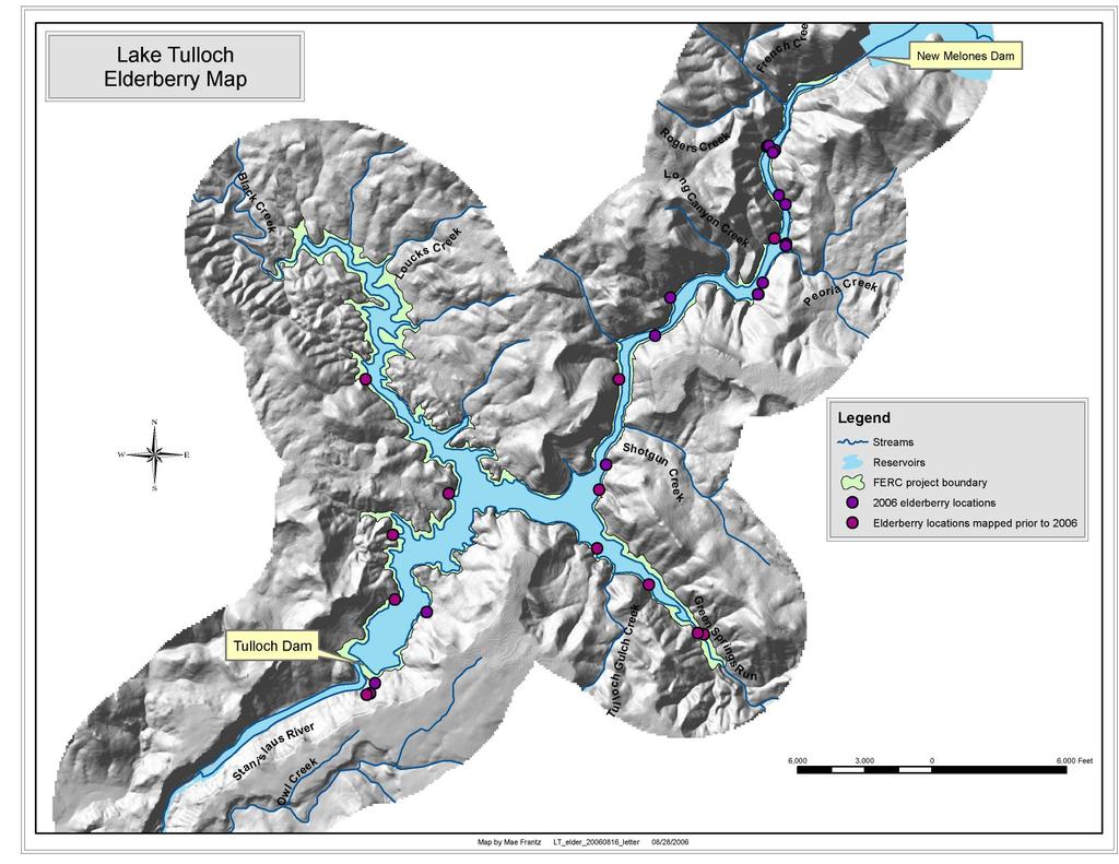
59
60
61 TRI-DAM PROJECT TULLOCH HYDROELECTRIC PROJECT TULLOCH RESERVOIR SHORELINE MANAGEMENT PLAN (May 2015) Attachment E (Public) Map of Vegetation Types within the FERC Project Boundary
62
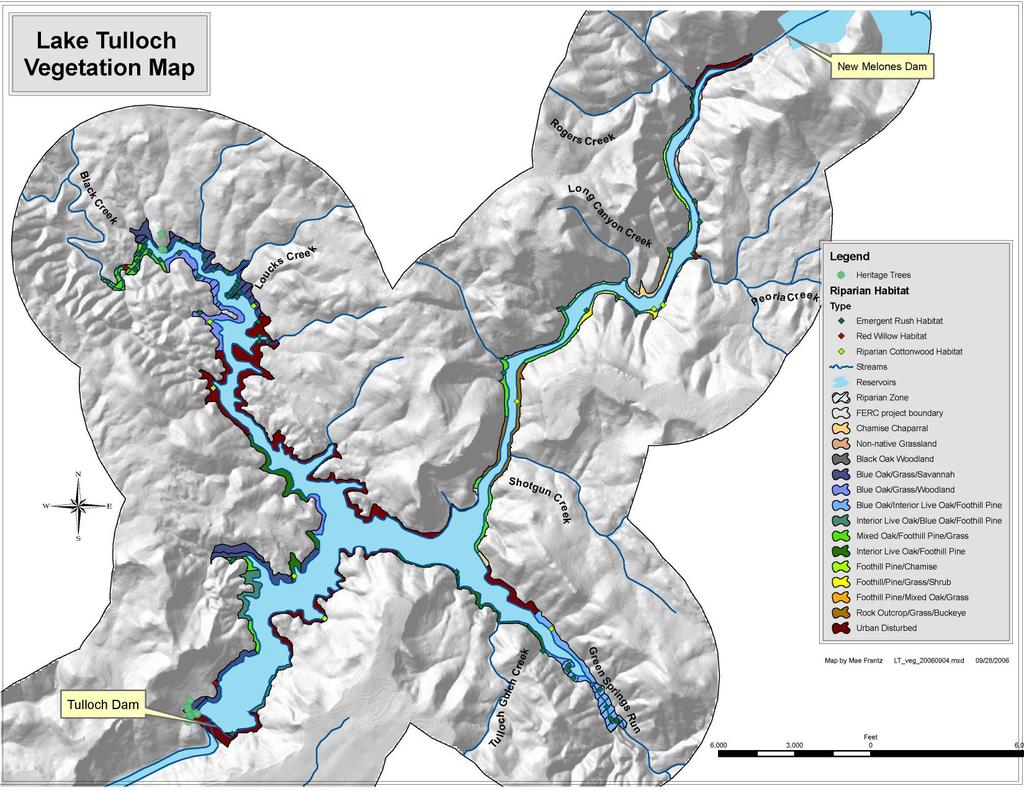
63
64
65 TRI-DAM PROJECT TULLOCH HYDROELECTRIC PROJECT TULLOCH RESERVOIR SHORELINE MANAGEMENT PLAN (May 2015) Attachment F (Public) Map of Noxious Weed Populations within the FERC Project Boundary
66

67
68
69 TRI-DAM PROJECT TULLOCH HYDROELECTRIC PROJECT TULLOCH RESERVOIR SHORELINE MANAGEMENT PLAN (May 2015) Attachment G (Privileged) Maps of Historic Property Locations at the Tulloch Hydroelectric Project NOT FOR PUBLIC RELEASE This map has been redacted from the public version of the SMP and filed with FERC as Privileged to avoid public disclosure of these sensitive resource locations. Copies of redacted maps will be provided to the resource agencies upon request.
70
71 TRI-DAM PROJECT TULLOCH HYDROELECTRIC PROJECT TULLOCH RESERVOIR SHORELINE MANAGEMENT PLAN (May 2015) Attachment H (Public) Consultation Record
72
73 Attachment H Consultation Record Contents: Tri-Dam Project Tulloch Hydroelectric Project FERC Project No December 31, 2014 Letter from Susan Larson providing draft SMP to Agency Distribution List January 13, 2015 Letter from John Buckley, Central Sierra Environmental Resource Center, commenting on Draft SMP January 14, 2015 Letter from Susan Larson providing draft SMP to landowners at Lake Tulloch January 15, from Rufus Farhina, residential property owner, commenting on Draft SMP January 16, from Mel Thompson, residential property owner, commenting on Draft SMP January 19, from Chris Meyers, residential property owner, commenting on Draft SMP January 19, from Ray Hoot, residential property owner, commenting on Draft SMP January 20, from Christina Browning, residential property owner, asking about relationship of SMP update to FEMA flood line issue January 27, from Debra Lewis, Calaveras County Planning Department, asking if the elevation datum provided in the SMP is in NGVD or is the historic Oakdale Irrigation District datum. January 28, 2015 letter from Don Wells, residential property owner, commenting on Draft SMP February 9, 2015 postcard from Mona Bowling, residential property owner, commenting on Draft SMP March 15, 2015 letter from Bernadette Cattaneo on behalf of The Resort at Lake Tulloch LLC commenting on the Draft SMP March 20, 2015 letter from Jim Lynch at HDR to property owners on Lake Tulloch announcing public meeting scheduled for April 11, 2015 in Copperopolis, CA to discuss proposed revision of SMP and comments received on the draft plan. Notice of April 11, 2015 public meeting published on March 27, 2015 in The Calaveras Enterprise Notice of April 11, 2015 public meeting published on March 27, 2015 in The Sonora Union Democrat Sign in sheet from the April 11, 2015 public meeting Presentation providing an overview of the SMP update process presented at the April 11, 2015 public meeting May 2015 Tulloch Reservoir Shoreline Management Plan Attachment H 2015, Tri-Dam Project Page H-1
74 Tri-Dam Project Tulloch Hydroelectric Project FERC Project No Table H-1. Tri-Dam's response to comments on the draft updated Tulloch Reservoir SMP. Cmt # Represents Commenter SMP Section Date Comment Summary Response to Comments RESPONSE TO COMMENTS FROM PARTIES LISTED FOR CONSULTATION IN ARTICLE United States Fish and -- Wildlife Service Did Not Provide Comments California Department of -- Fish and Wildlife Did Not Provide Comments Tuolumne County Did Not Provide Comments Copper Cove at Lake Tulloch Owners' -- Association Did Not Provide Comments Lake Tulloch Alliance Did Not Provide Comments Conner Estates Master -- Association Did Not Provide Comments Black Jack Bluffs -- Association Did Not Provide Comments Peninsula Estates -- Association Did Not Provide Comments Lake Tulloch Shores -- Subdivision Did Not Provide Comments Calypso Bay Property -- Owners Did Not Provide Comments -- CPD-1 Calaveras Planning Department RLT-1 The Resort at Lake Tulloch LLP Debra Lewis 1.0 1/27/15 Asked if the elevation datum for the reservoir is actually in NGVD as stated in the Draft SMP, noting that she understands the Tulloch Lake 515' boundary elevation is in a historic Oakdale Irrigation District datum that represents a 1.5' difference (doesn't note if NGVD is higher or lower). Bernadette Cattaneo 1.0 3/15/15 Statement of opinion that FERC's license approval of the SMP in 2002 does not provide Tri-Dam with the authority to grant permission for non-project use of lands within the FERC Project Boundary. The datum used by Tri-Dam is the Project Boundary established by FERC, which includes all lands at the 515 ft contour and below, as measured from local benchmarks tied to the dam elevation and reservoir. FERC has jurisdiction over the management of lands encompassed by the FERC Project Boundary and, though Articles 411 and 413, requires Tri-Dam to supervise and control shoreline development to ensure it is consistent with Project purposes, which include protection of the Project's primary purpose as well as FERC PDF (Unofficial) 4/30/2015 4:22:10 PM May 2015 Tulloch Reservoir Shoreline Management Plan Attachment H 2015, Tri-Dam Project Page H-2
75 Cmt # Represents Commenter RLT-2 RLT-3 The Resort at Lake Tulloch LLP The Resort at Lake Tulloch LLP SMP Section Tri-Dam Project Tulloch Hydroelectric Project FERC Project No Date Comment Summary Response to Comments Bernadette Cattaneo 1.2 3/15/15 Suggests that the goal of the SMP should be that the permit program is based on "guidelines" and not requirements that are enforceable by Tri-Dam. Bernadette Cattaneo 1.3 3/15/15 Notes that residential and land use development of the lands surrounding Lake Tulloch are under the jurisdiction of either Calaveras or Tuolumne Counties, and that the Counties have not delegated this authority to Tri-Dam. scenic, recreational and environmental values. The purpose of the SMP, like all SMP s is to establish clear and concise regulations for the balancing of resources at the reservoir, such that development occurs in an orderly fashion. The Tulloch Reservoir SMP was developed pursuant to the requirements of Article 411 and provides a set of consistent procedures that allow Tri- Dam to permit minor development activities within the FERC project boundary without prior FERC approval. Larger scale shoreline development proposals still require prior FERC approval under the revised SMP. Tulloch Reservoir does include lands within two counties: Calaveras and Tuolumne. These agencies do have regulatory authority over various aspects of development, yet this does not change regulatory authority established by the Federal Power Act, and obligations delegated to Tri-Dam through the issuance of the license. The purpose of the SMP regulations are to establish a clear framework for shoreline development for shoreline landowners while also providing protection for reservoir resources., Just as resource agencies like the U.S. Army Corps of Engineers, California Department of Fish and Wildlife also have authority, the counties have overlapping regulatory authority over certain aspects of development of lands within their jurisdiction, yet the existence of said authority does not alter the scope of Tri FERC PDF (Unofficial) 4/30/2015 4:22:10 PM Attachment H Tulloch Shoreline Management Plan May 2015 Page H , Tri-Dam Project
76 Tri-Dam Project Tulloch Hydroelectric Project FERC Project No Cmt # Represents Commenter RLT-4 RLT-5 RLT-6 The Resort at Lake Tulloch LLP The Resort at Lake Tulloch LLP The Resort at Lake Tulloch LLP SMP Section Date Comment Summary Response to Comments Bernadette Cattaneo 1.5 3/15/15 Suggests that proper notification of future SMP updates be provided to private property owners. Bernadette Cattaneo 2.0 3/15/15 Requests that Goal 3 be struck from the SMP and that the SMP simply focus on impacts to project resources from actions directly attributable to Tri-Dam's operation and maintenance of the hydroelectric project. Bernadette Cattaneo 3.0 3/15/15 Notes that there is only one public access facility currently at the lake and that Drifter's Marina is privately owned and not open to the public. Also provides comment about development of Drifters Marina and involvement of Tri-Dam staff. Dam s responsibility to comply with FERC license provisions.. See Tri-Dam's previous response to Comment RLT-1 for an overview of FERC jurisdiction over activities within the established FERC Project boundary. FERC established the required consulting parties for updating the SMP in Article 411 of the new license. Tri-Dam followed the precise specifications included in Article 411, providing notification to all parties as indicated. In addition, Tri-Dam has far exceeded the notification protocol by providing direct mail notification to all shoreline property owners, using the notification information obtained from the official records of each county. Management of Project impacts is already established at Tulloch Reservoir under FERC's license and the various resource management plans included in the license. FERC's SMP program is specifically designed to ensure consistency with the terms of the project license when issuing permits to other parties to conduct shoreline development activities at FERClicensed hydropower projects. Section 3.0 of the SMP has been updated to reflect that South Shore Marina is a public marina, while Drifters Marina is a private commercial marina. A review of the development of Drifters Marina files indicates that all aspects of the permitting and review of the facility were handled by the former General Manager, Steve Felte with no involvement of other Tri-Dam staff members FERC PDF (Unofficial) 4/30/2015 4:22:10 PM May 2015 Tulloch Reservoir Shoreline Management Plan Attachment H 2015, Tri-Dam Project Page H-4
77 Tri-Dam Project Tulloch Hydroelectric Project FERC Project No Cmt # Represents Commenter SMP Section Date Comment Summary Response to Comments RLT-7 The Resort at Bernadette Cattaneo 3.1 3/15/15 Notes that all permitting of private FERC requires Tri-Dam, like the majority Lake Tulloch development should be managed by the of licensees around the country with LLP Counties and that any direction to consult development along the shoreline of it s with state and federal resource agencies reservoir to manage shoreline development should be made by the Counties instead of Tri-Dam. at Lake Tulloch under Articles 411 and 413. See Tri-Dam's response to Comment RLT-1 for an overview of FERC jurisdiction over activities within the established FERC Project Boundary. RLT-8 The Resort at Bernadette Cattaneo 3.5 3/15/15 Opposes the establishment of any additional See Tri-Dam's response to Comment Lake Tulloch 5 MPH zones or non-motorized boating CSERC-5. LLP areas in the Green Springs and Black Creek arms of Lake Tulloch. RLT-9 The Resort at Bernadette Cattaneo 4.0 3/15/15 Questions the legality of Tri-Dam's entire FERC requires Tri-Dam to manage Lake Tulloch shoreline permitting process. shoreline development at Lake Tulloch LLP under Articles 411 and 413. See Tri- Dam's response to Comment RLT-1 for an overview of FERC jurisdiction over activities within the established FERC Project Boundary. RLT-10 The Resort at Bernadette Cattaneo /15/15 Requests that the Tri-Dam Project The application forms are always readily Lake Tulloch Application Form be included as part of the available on the Tri-Dam website, but are LLP SMP and notes that the application process is confusing at best. not officially a part of the SMP. RLT-11 The Resort at Bernadette Cattaneo /15/15 Requests that construction progress should FERC requires Tri-Dam to monitor Lake Tulloch be monitored by the counties and not by shoreline development at Lake Tulloch LLP Tri-Dam under the FERC project license. under Articles 411 and 413. Additionally, other agencies may also include monitoring of any additional permits needed for proposed shoreline development permitted under the SMP. See Tri-Dam's response to Comment RLT- 1 for an overview of FERC jurisdiction over activities within the established FERC Project Boundary. RLT-12 The Resort at Bernadette Cattaneo /15/15 Requests that inspections should be FERC requires Tri-Dam to inspect Lake Tulloch conducted by the counties and not by Tri- shoreline development sites permitted FERC PDF (Unofficial) 4/30/2015 4:22:10 PM Attachment H Tulloch Shoreline Management Plan May 2015 Page H , Tri-Dam Project
78 Tri-Dam Project Tulloch Hydroelectric Project FERC Project No Cmt # Represents Commenter SMP Section Date Comment Summary Response to Comments LLP Dam under the FERC project license. under the SMP at Tulloch Reservoir under Article 411 for compliance with permit conditions. Additionally, other agencies may also include site inspection in relation to any additional permits needed for proposed shoreline development permitted under the SMP. See Tri-Dam's response to Comment RLT-1 for an overview of FERC jurisdiction over activities within the established FERC Project Boundary. RLT-13 The Resort at Bernadette Cattaneo /15/15 Requests that Tri-Dam's role in issuing FERC requires Tri-Dam to issue permits Lake Tulloch encroachment permits at Lake Tulloch be for shoreline development allowed under LLP revoked and that Tri-Dam should only have review authority. the SMP at Tulloch Reservoir under Articles 411 and 413, which includes the issuance of permits. Additionally, other agencies may also require additional permits that must be obtained before Tri- Dam issues the requested Encroachment Permit. See Tri-Dam's response to Comment RLT-1 for an overview of FERC jurisdiction over activities within the RLT-14 RLT-15 The Resort at Lake Tulloch LLP The Resort at Lake Tulloch LLP Bernadette Cattaneo /15/15 Requests that enforcement of violations be conducted by the counties and not by Tri- Dam under the FERC project license. Bernadette Cattaneo /15/15 Requests that all commercial development be conducted by the counties and not by Tri-Dam under the FERC project license. Also notes that commercial development criteria are much too restrictive and that the established FERC Project Boundary. FERC requires Tri-Dam to enforce the shoreline development permits issued under the SMP at Lake Tulloch under Articles 411 and 413. Additionally, permits required by other agencies will similarly be enforced by the agencies that issue the permits. See Tri-Dam's response to Comment RLT-1 for an overview of FERC jurisdiction over activities within the established FERC Project Boundary. FERC requires Tri-Dam to manage residential shoreline development at Tulloch Reservoir under Articles 411 and 413. See Tri-Dam's response to Comment RLT-1 for an overview of FERC FERC PDF (Unofficial) 4/30/2015 4:22:10 PM May 2015 Tulloch Reservoir Shoreline Management Plan Attachment H 2015, Tri-Dam Project Page H-6
79 Cmt # Represents Commenter RLT-16 RLT-17 RLT-18 The Resort at Lake Tulloch LLP The Resort at Lake Tulloch LLP The Resort at Lake Tulloch LLP SMP Section Tri-Dam Project Tulloch Hydroelectric Project FERC Project No Date Comment Summary Response to Comments procedures should be revised with input from commercial property owners, noting that there is no way that a commercial facility can comply with the criteria in the draft SMP. Bernadette Cattaneo /15/15 Restates earlier request that all private development be conducted by the counties and not by Tri-Dam under the FERC project license. The reason given here is that the current SMP interferes with private property rights and that several of the required criteria have no effect on operation of the project. Bernadette Cattaneo /15/15 Requests that permits for excavation be managed by the counties in conjunction with the agencies deemed to have review and approval authority, and not managed by Tri-Dam under the FERC project license. Bernadette Cattaneo /15/15 Requests that permits for shoreline and erosion control be managed by the counties and not by Tri-Dam under the FERC project license. jurisdiction over activities within the established FERC Project Boundary. FERC requires Tri-Dam to manage residential shoreline development at Tulloch Reservoir under Articles 411 and 413. See Tri-Dam's response to Comment RLT-1 for an overview of FERC jurisdiction over activities within the established FERC Project Boundary. FERC requires Tri-Dam to manage residential shoreline development at Tulloch Reservoir under Articles 411 and 413. All permits issued at Tulloch Reservoir for excavation or dredging may require additional permits by the U.S. Army Corps of Engineers and/or the California Department of Fish and Wildlife. Tri-Dam requires the applicant to consult with and obtain all necessary permits and approvals. See Tri-Dam's response to Comment RLT-1 for an overview of FERC jurisdiction over activities within the established FERC Project Boundary. FERC requires Tri-Dam to include measures for shoreline stabilization and erosion control in the encroachment permits issued under the SMP at Tulloch Reservoir under Article 411. See Tri- Dam's response to Comment RLT-1 for an overview of FERC jurisdiction over activities within the established FERC Project Boundary FERC PDF (Unofficial) 4/30/2015 4:22:10 PM Attachment H Tulloch Shoreline Management Plan May 2015 Page H , Tri-Dam Project
80 Tri-Dam Project Tulloch Hydroelectric Project FERC Project No Cmt # Represents Commenter SMP Section Date Comment Summary Response to Comments RLT-19 The Resort at Bernadette Cattaneo /15/15 Notes that buoys and signage is already Buoys and signage are currently managed Lake Tulloch addressed in Title 20 and should be handled by Tri-Dam in conjunction with Calaveras LLP as they are now. and Tuolumne County Sheriff departments. Tri-Dam is not proposing any changes to The Buoy Master Plan Program (which was developed for consistency with Title 20) as part of the updated SMP. The buoy plan is subject to change each year, as specified by law enforcement. Tri-Dam installs, monitors and updates buoy locations as needed each season, in conjunction with input from Calaveras and Tuolumne Marine Safety Divisions. RESPONSE TO COMMENTS BY OTHER CONSULTED PARTIES U.S. Bureau of Reclamation Did Not Provide Comments U.S. Bureau of Land Management Did Not Provide Comments -- CSERC-1 CSERC John Buckley /14/15 To address issues of watercraft crowding on the lake, recommends that new commercial Section of the updated SMP allows new commercial facilities to extend no facilities be limited to the lesser of 1/3 more than one-third of the distance to the distance across the lake or 50 feet. opposite shore or 100 ft from the shoreline, whichever is less. FERC's standard land use article is attached to the FERC license as Article 413 and frames what approvals Tri-Dam can permit under its license. The portions of Article 413 that address permitting of commercial development at the Project have been added to the updated SMP, Introduction, to provide background on these permitting provisions authorized CSERC-2 CSERC John Buckley /14/15 For new single family docks, recommends that they extend no more than 30 feet from shoreline and to limit the allowed docking area to be 300 sf for a slip or platform dock. under the FERC license. Section of the SMP allows new residential facilities to extend no more than 40 feet from the shoreline and to be limited to a maximum size of 440 sq. ft for a u FERC PDF (Unofficial) 4/30/2015 4:22:10 PM May 2015 Tulloch Reservoir Shoreline Management Plan Attachment H 2015, Tri-Dam Project Page H-8
81 Cmt # Represents Commenter SMP Section Tri-Dam Project Tulloch Hydroelectric Project FERC Project No Date Comment Summary Response to Comments CSERC-3 CSERC John Buckley /14/15 Recommends that dredging at private residences approved by Tri-Dam be reduced from 1,000 cy to 100 cy. CSERC-4 CSERC John Buckley No reference 1/14/15 Requests that SMP include a discussion of the cumulative impacts of past, present and reasonably foreseeable future development impacts on the aquatic, scenic and water quality resources of the reservoir. The comment goes on to discuss Tri-Dam s 2008 response to this comment and notes that Tri-Dam has a legal responsibility to consider cumulative impacts when shaped dock, and 400 sq. ft for a platform type dock. The updated draft, as prepared does not propose any changes to the dock sizes. These sizes were developed with extensive public input and participation during the re-licensing process, and have been consistently implemented since adoption. Refer also to Tri-Dam's response to Comment RF-1. The current SMP allows up to a maximum of 1,000 cubic yards of material to be excavated provided that such work is done with a permit and under strict specifications. This limitation is consistent with established by other permitting agencies (e.g., U.S. Corps of Engineers and Cal Fish and Wildlife) and helps to addresses navigability issues of concern to shoreline abutters, while limiting impacts to aquatic habitat at the Project. All requests for excavation permits under the SMP must be supported by permits issued by the appropriate regulatory agency or documentation that waivers of this permits have been issued, before Tri-Dam will issue written authorization allowing the proposed activity. The SP is management plan that provides consistent guidelines to applicants seeking permission to construct minor shoreline facilities at Lake Tulloch. The effects of the implementation of the SMP were assessed in the NEPA evaluation conducted by FERC and the CEQA assessment completed during relicensing. The standards within the SMP, by providing consistent standards for FERC PDF (Unofficial) 4/30/2015 4:22:10 PM Attachment H Tulloch Shoreline Management Plan May 2015 Page H , Tri-Dam Project
82 Tri-Dam Project Tulloch Hydroelectric Project FERC Project No Cmt # Represents Commenter SMP Section Date Comment Summary Response to Comments developing SMP procedures that "must be consistent with NEPA". CSERC-5 CSERC John Buckley Notes that although establishment of nonboating areas in the Black Creek and Green Springs Wildlife areas to help protect ospreys, bald eagles, western pond turtle and other at-risk species has been discussed, it still hasn't been established. development along the shoreline and permitting review for all construction and other activities proposed within the FERC Project Boundary, will serve to protect the aquatic, scenic and water quality resource of the reservoir. And it is for many of the reasons noted in this comment that Tri- Dam is not proposing to increase dock size, extension into the reservoir and excavation limits, despite public comment seeking additional changes that would allow these items. The SMP must include these types of limitations to provide for the cumulative protection of the reservoir, as is the goal of CSERC and Tri-Dam. If an assessment is needed, Tri-Dam anticipates that will be identified by another agency (e.g., U.S. Corps of Engineers or Cal Fish and Wildlife) when the developer consults with them. As noted in the updated SMP, both the Green Springs and Black Creek arms currently have established 5-MPH zones that are enforced by the County Sheriff Departments. The Wildlife Management Plan developed under Article 407 includes provisions to work with the counties to restrict motorized boating in the upper reached of these two arms to help protect ospreys, bald eagles, western pond turtle and other at risk species at Tulloch Reservoir and management provisions for these species of concerns are being implemented at Tulloch Reservoir. As required by the FERC Article 407, Tri- Dam hired a licensed biologist to prepare a report evaluating the potential FERC PDF (Unofficial) 4/30/2015 4:22:10 PM May 2015 Tulloch Reservoir Shoreline Management Plan Attachment H 2015, Tri-Dam Project Page H-10
83 Cmt # Represents Commenter SMP Section CSERC-6 CSERC John Buckley No reference CSERC-7 CSERC John Buckley No reference Tri-Dam Project Tulloch Hydroelectric Project FERC Project No Date Comment Summary Response to Comments 1/14/15 There is still no firm movement by Tri-Dam to comply with FERC's license order requiring the establishment of a public access site for recreation at reservoir. Also surprised that past efforts to provide a recreational access parcel with road access on the Calaveras County side of the Black Creek Arm isn't discussed in the SMP. 1/14/15 Requests that the SMP addresses the development of new facilities within the FERC project boundary and include provisions that minimize further crowding implementation of non-motorized boating zones around the reservoir. This report was forwarded to both Tuolumne and Calaveras counties for comment, along with all State and Federal resource agencies. While Tuolumne County recommended the implementation of a non-motorized boating zone in the upper reaches of Green Springs, Tri-Dam is still awaiting comment from Calaveras County regarding the biological evaluation and potential implementation for a nonmotorized boating zone. Tri-Dam works cooperatively with both counties, and will continue to implement such zones, or future zones if needed, is addressed by the Wildlife Management Plan, Public access and recreation are addressed by Article 409 of the FERC license. Tri- Dam initially filed an application with the Bureau of Land Management seeking to develop the 14 acre site within the Black Creek Arm of the reservoir in 2004, in advance of issuance of the FERC license. Tri-Dam has filed a Draft Recreation Plan with FERC, and continues to pursue the development of a public access site on the Calaveras side of the reservoir, in compliance with FERC directives. This topic is not addressed by the SMP as it is thoroughly evaluated and explained in the Reservoir Recreation Plan, as specified by Article 409. The updated SMP addresses, within the limits of Article 411, the development of new facilities within the FERC Project Boundary. Provisions for the development FERC PDF (Unofficial) 4/30/2015 4:22:10 PM Attachment H Tulloch Shoreline Management Plan May 2015 Page H , Tri-Dam Project
84 Tri-Dam Project Tulloch Hydroelectric Project FERC Project No Cmt # Represents Commenter SMP Section Date Comment Summary Response to Comments and development along the shoreline, including prohibiting new development or structures (other than docks) to protrude over the water. RF-1 Property Owner Rufus Farhina /15/15 Water Ports / Jet Ski Ports in item #7 are too small for current standard vessel sizes. Recommends this be revised to allow 5'x13' ports, upping allowed area from 50 sf to 65 sf. of new facilities under the updated SMP provides a consistent process that shoreline abutters can use to seek permits to construct water-based facilities at Tulloch Reservoir. The SMP provides specifications for shoreline development for existing, legally created properties. The ultimate issue of continued crowding of the shoreline and prohibition of further development would rest with both Calaveras and Tuolumne counties as they establish General Plan land use designations for future parcel sizes around the reservoir. Tri-Dam will actively review such development proposals, and provide comments to the county seeking to ensure the protection of the reservoir resources, consistent with these comments. In terms of development above the reservoir, the only subdivision which can be built over the reservoir is the Poker Flat-Lake Tulloch Shores subdivision, and this approval was granted in 1974 by FERC for implementation by Tri-Dam. While allowing certain portions of the structure to be constructed above the reservoir, such as decks, and components of the structure, the proposal must still comply with regulations of the SMP. All other areas of the reservoir cannot include any elements of the proposal which are suspended above the reservoir. The existing SMP allows landowners to apply for up to two (2) personal watercraft ports, not exceeding 5 ft x 10 ft each for a total of 100 square feet each. Given that 5 ft x 10 ft personal watercraft ports are FERC PDF (Unofficial) 4/30/2015 4:22:10 PM May 2015 Tulloch Reservoir Shoreline Management Plan Attachment H 2015, Tri-Dam Project Page H-12
85 Cmt # Represents Commenter SMP Section Tri-Dam Project Tulloch Hydroelectric Project FERC Project No Date Comment Summary Response to Comments MT-1 Property Owner Mel Thompson /16/15 Requests that this section of the SMP be revised to implement the main recommendations of the Project's Aquatic Vegetation Management Plan which involves lowering the reservoir annually to expose the bottom of shallow areas to control aquatic weed growth. MT-2 Property Owner Mel Thompson /16/15 Requests that Tri-Dam establish a nonmotorized boating area in the Black Creek Arm of the Lake and disagrees that Tri-Dam does not currently have sufficient authority to implement this change independently. CM-1 Property Owner Chris Meyers /19/15 Requests increasing personal watercraft port size to 5 x RH-1 Property Owner Ray Hoot /19/15 Requests that jet ski port sizes be expanded to at least 5'X13.5' to accommodate larger jet skis commonly sold today, noting this is not manufactured in 5 ft x 10 ft sizes any longer, Section of the updated SMP has been modified to address this comment by removing the increasing the size restriction for the Jet Ski Ports and allowing permit holders to apply for up to allow two (2) personal watercraft ports, not exceeding seventy (70) square feet each for a total of 140 square feet. This issue is outside the scope of the updated SMP because the SMP is specifically designed to ensure consistency with conditions of the Project license during permitting of requested shoreline development activities. The management of invasive aquatic species is handled under the Aquatic Vegetation Management Plan in the FERC license, not the SMP. The Aquatic Management Plan was developed by a citizen/agency group of local residents and agencies, and includes measures designed to prevent the proliferations of invasive aquatic species. CSERC participated in the development of the Aquatic Management Plan, providing valuable input into the currently pending plan. See Tri-Dam s response to Comment CSERC-5 See Tri-Dam's response to Comment RF-1. See Tri-Dam's response to Comment RF FERC PDF (Unofficial) 4/30/2015 4:22:10 PM Attachment H Tulloch Shoreline Management Plan May 2015 Page H , Tri-Dam Project
86 Tri-Dam Project Tulloch Hydroelectric Project FERC Project No SMP Cmt # Represents Commenter Section the smallest size currently available. DW-1 Property Owner Don Wells NA 1/28/15 Concerned about Quagga and Zebra Mussels in the lake and suggests tighter controls like those in place at Lake Tahoe should be incorporated into the SMP. Also proposed to ban two-stroke motors from the lake. Attached 3 documents to his 2-page comment letter. Date Comment Summary Response to Comments MB-1 Property Owner Mona Bowling NA 2/9/15 Requests that the SMP update not add any fees or take away the rights of property owners. This issue is outside the scope of the SMP because the SMP is specifically designed to ensure consistency with conditions of the Project license during permitting of requested shoreline development activities. Management of invasive aquatic species is handled under the Aquatic Vegetation Management Plan in the FERC license, and not under the SMP. Tri-Dam has taken significant measures to prevent the introduction of Quagga and Zebra Mussels at Tulloch Reservoir, including a Self Inspection and Certification program, implemented by all subdivisions around the reservoir, private and public marinas. Tri-Dam is part of the Northern California Consortium, implementing consistent policies designed to prevent the introduction of these species at Tulloch Reservoir. In addition, although beyond the scope of the SMP, Tri-Dam has recently been awarded a grant from the California Department of Boating and Waterways to install a Boat Wash Decontamination Station at the South Shore Public Marina, and is currently working on finalization of the Grant Agreement. The issue of 2 stroke engines at area reservoirs should be the subject of public input, and action by both Calaveras and Tuolumne counties, if deemed warranted in the future. The updated SMP does not change the fees in the existing Tulloch Reservoir SMP or take away any rights of property owners. The updated SMP does not discuss FERC PDF (Unofficial) 4/30/2015 4:22:10 PM May 2015 Tulloch Reservoir Shoreline Management Plan Attachment H 2015, Tri-Dam Project Page H-14
87 Cmt # Represents Commenter SMP Section Tri-Dam Project Tulloch Hydroelectric Project FERC Project No Date Comment Summary Response to Comments GB-1 Property Owner George Burckhardt 6.3 4/1/15 Asks why can t owners enclose structures suggest removing restrictions GB-2 Property Owner George Burckhardt 6.3 4/1/15 Asks why are there limits on canopies suggest allowing canopies to extend over PWC ports and to allow extension of about 10 feet over each side application fees for various facilities, as this is addressed by separate document. FERC license authority allows Tri-Dam, like other licensees to charge application fees for various projects. In terms of provisions of the SMP and property rights, FERC requires that many licensees with shoreline development adopt SMP s. The goal of an SMP is not to take away property rights, but to establish consistent standards for shoreline development which ultimately protect and reservoir property values by protecting and enhancing the reservoir resource values. Guidelines of the current SMP were developed with extensive public input, over many weeks and months. The issue of enclosures around docks and other structures was widely discussed, and ultimately it was determined that enclosing structures floating on the reservoir would potential created public safety issues. Enclosing structures would reduce line of sight by watercraft operators, which could lead to accidents. Further, enclosing the structures would limit Sheriffs views related to law enforcements. In addition, this would limit the view of other landowners that may have a nearby dock, having aesthetic impacts and detract from the scenic qualities of the reservoir. Guidelines of the SMP were developed with extensive public input, over many weeks and months. Given that many personal watercraft have covers, it was ultimately decided that canopies or other covers would be limited to the footprint of FERC PDF (Unofficial) 4/30/2015 4:22:10 PM Attachment H Tulloch Shoreline Management Plan May 2015 Page H , Tri-Dam Project
88 Tri-Dam Project Tulloch Hydroelectric Project FERC Project No Cmt # Represents Commenter SMP Section Date Comment Summary Response to Comments GB-3 Property Owner George Burckhardt 7.3 4/1/15 Asks why are there limits on excavation suggest removing limit CB-1 Property Owner Christina Browning 1.0 1/20/15 Asks if SMP update has anything to do with FEMA flood line issue. the dock only, and that additional covers would not be authorized. Primary reasons cited were public safety concerns and protection of view corridors within many areas of the reservoir, where such covers and other structures could block visibility and detract from the scenic qualities of the reservoir. See Tri-Dam's response to Comment CSERC-3. FEMA mapping issues are not addressed by the SMP FERC PDF (Unofficial) 4/30/2015 4:22:10 PM May 2015 Tulloch Reservoir Shoreline Management Plan Attachment H 2015, Tri-Dam Project Page H-16
89
90 Distribution List California Department of Fish and Wildlife 1701 Nimbus Road, Suite A Rancho Cordova, CA United States Department of the Interior, Fish and Wildlife Service 2800 Cottage Way, Suite W-2605 Sacramento, CA Calaveras County Planning Department 891 Mountain Ranch Road San Andreas, CA John Buckley CSERC P.O. Box 396 Twain Harte, CA Lake Tulloch Shores Subdivision 385 Poker Flat Road Copperopolis, CA US Bureau of Land Management Attn: Jim Eicher 5152 Hillsdale Circle El Dorado Hills, CA Tuolumne County Community Resources Agency, Planning Division 2 South Street Sonora, CA Copper Cove at Lake Tulloch Owners Association 920 Black Creek Drive Copperopolis, CA Lake Tulloch Alliance 4150 La Cross Court Copperopolis, CA Connor Estates Master Association Black Jack Bluffs Association Peninsula Estates Association c/o MC Association 171 Town Square Road Copperopolis, CA CALYPSO BAY PROPERTY OWNERS' ASSOCIATION 420 Calypso Beach Drive Copperopolis, CA US Bureau of Reclamation Administrative Office 6850 Studhorse Flat Road Sonora, CA 95370
91
92

93 Central Sierra Environmental Resource Center Box 396, Twain Harte, CA (209) fax (209) Visit our website at: or contact us at: January 13, 2015 Tri Dam Project P.O. Box 1158 Pinecrest, CA Cc: Susan Larson License Compliance Coordinator Robert Fletcher and Shana High FERC, D.C. Comments in response to the Revised Tulloch Reservoir Shoreline Management Plan Dear Susan and others at the Tri Dam Project: As you are aware, the staff at our non profit center engaged diligently throughout the entire FERC relicensing process for the Tulloch Hydroelectric Project (and the associated Spring Gap Stanislaus and Beardsley Donnells Relicensing Projects). In all, our staff invested a total of 188 days in attending meetings, work sessions, field visits, public information sessions, and other meetings tied to the bundle of FERC licenses. In addition, as you also are aware, I participated in various meetings with Tri Dam and various homeowner association representatives and others concerned about Tulloch Reservoir management issues. Finally, I have attended sessions of the Tulloch Reservoir Shoreline Management Subgroup. From this highly engaged background perspective, as the executive director for our non profit center, I have submitted detailed comments for the Tulloch Reservoir Shoreline Management Plan as well as specific draft plans for dealing with invasive aquatic weeds, for converting two key arms of the reservoir to non motorized boating, and a focused plan for providing public recreation access to Tulloch Reservoir. During the years of interaction, I have developed a high amount of respect for Tri Dam employees and consultants, and I have come to understand a considerable degree of the challenges Tri Dam faces with shoreline and reservoir management. Accordingly, it is with a spirit of respect and collaboration that I nevertheless provide the following comments of frustration and concern for the lack of responsiveness from Tri Dam for strengthening the Tulloch Reservoir Shoreline Management Plan. Despite the majority of the Plan being appropriate and well written, the points of objection that our Center submitted in our comments in 2008 are still exactly the same in every instance, with no improvement or strengthening. SPECIFIC COMMENTS REQUESTING CHANGES IN THE FINAL PLAN
94 The draft revised Shoreline Plan provides some brief information on page 3 1 that describes the build out of Copper Cove (1,000 units), Lake Tulloch Shores (600 units), and Conner Estates (169) units. The Plan explicitly describes these developments as only 30 percent built out. The Tuscany Hills subdivision (described in the Plan as 300 units) is also approved by Calaveras County. Page 1 8 of the Plan reveals that there are already 500 single family residential docks along the shoreline. Most of the docks are designed with one slip; however, it is common to see additional watercraft tied to the sides of these docks. During many Tulloch related public meetings and even in comments submitted in 2008 for this Shoreline Plan, citizens complained about overcrowding of the lake by motorized watercraft especially during summer season high use periods. Pressure to create more docks is high because of the intensely hot summer weather. Accordingly, the potential for docks to further crowd the shoreline is also very high. In our previous 2008 CSERC comments we asked that new commercial facility docks be limited to sticking out into the lake no more than 1/3 across the lake or 50 feet (whichever is more limiting), rather than 100 feet as proposed by Tri Dam. For new single family residential docks, we asked that docks be limited to extend no more than 30 from the shoreline, rather than 40, and we recommended a reduction in the maximum allowed docking area to be constructed for single family residential facilities to be 300 square feet for either a slip type or platform dock, rather than 440 or 400. In addition, CSERC provided strong concern over a baseline threshold of 1,000 cubic yards of soil that is described as the maximum material that could be excavated with Tri Dam approval by a single family residential applicant at the shoreline. Our Center specifically requested that excavation at the shoreline with high potential for impacts to the reservoir be limited to 100 cubic yards (still a significant amount of excavation) per single family residence not 1,000 cubic yards. All of these specific requests were based upon a huge potential increase in coming years for requested permits for new docks or new excavation that would diminish recreational values, crowd and degrade the shoreline, cause even greater impacts to wildlife than at present, and also potentially degrade water quality from so many boats cumulatively leaking petroleum products or other contaminants. All of CSERC s requests described above were ignored or were rejected in this Draft Revised Shoreline Plan. No changes were made for any of those specific requests submitted in comments. In addition to CSERC requesting reductions in the distance that new docks could protrude into the lake and the size of new docks, CSERC specifically asked in our comments of May 16, 2008 for the Shoreline Plan to discuss the cumulative impacts of past, present, and reasonably foreseeable future development impacts on the aquatic, scenic, and water quality resources of the reservoir. If the not yet built percentage number of 1,450 lots results in additional boating and dock pressure on the reservoir shoreline, and if even more additional planned, but not yet approved, projects add to that pressure, the environmental impacts could be significant.
95 In the Response to Comments section in the Appendices, Tri Dam dismisses the need for cumulative analysis by asserting that the Shoreline Plan provided a narrative of approved projects, and that the Tri Dam has no authority to provide approval for development in with Calaveras or Tuolumne County. CSERC obviously never expected Tri Dam to exceed its authority. CSERC does, however, expect Tri Dam to fulfill its legal responsibility to consider cumulative impacts when approving management planning that must be consistent with NEPA. WHY DOES IT MATTER? Despite positive wording throughout key sections of the Shoreline Management Plan, in reality much of the text is based upon Tri Dam encouraging or recommending to property owners or counties that some action or outcome be taken. Other than mandating for applicants to follow certain procedures to apply for permits, much of the mitigation intended to avoid significant impacts is not assured to ever be implemented due to non mandatory language. In particular, the non motorized boating areas described as the Black Creek Wildlife Area and the Green Springs Wildlife Area look good in photos in the Plan, but in all the years since the FERC license was renewed, no establishment of the Black Creek or Green Springs nonmotorized boating area has ever yet been approved. As our comments in 2008 pointed out, and we now reiterate, there is no assurance that Tri Dam s intentions on paper will ever translate into firm action to establish the wildlife areas and non motorized boating areas in those two arms to help protect ospreys, bald eagles, western pond turtle, and other at risk species through the establishment of wildlife non motorized areas. Similarly, after all of the years since being required by the FERC to establish a public access site for recreational visitors to the Reservoir, there is still no clear movement to actually comply with FERC direction and spend the money needed or take the actions needed to resolve hurdles that have delayed compliance for acquiring public access. Surprisingly, there is no description provided in the Shoreline Management Plan of the conceptual proposed creation of a recreational access parcel with road access on the Calaveras County side of the reservoir in the Black Creek arm. Accordingly, similar to the lack of any clear assurance that the non motorized boating areas will be achieved, there is also no assurance that a recreational access site for the general public will ever actually be provided at the Reservoir. Instead, page 2 3 of the Shoreline Management Plan simply encourages the counties to develop and maintain facilities to provide public access to the reservoir. CSERC pointed out in our 2008 comments that much of the content of implementation measures in this Shoreline Management Plan is actually only well intended wording to encourage or support some action. Encouragement cannot be relied upon to meet NEPA or CEQA or FERC requirements. Encouragement is often meaningless without clear timelines, requirements, or specific measurable steps to be taken. LACK OF CLARITY ABOUT CONSTRUCTION WITHIN THE FERC BOUNDARY AREA As provided in detail twice in 2008 and now again in 2015, one of CSERC s greatest concerns is that the Tulloch Shoreline Management Plan fails to address the issue of development of new
96 structures being allowed to be constructed or located within the FERC boundary (either to the edge of the water or even potentially protruding out over the water). THIS IS A HIGHLY SIGNIFICANT GAP. We are not expecting Tri Dam to dictate any policy above the 515 contour elevation (unless some project poses significant negative impact to the reservoir or to resources under Tri Dam s responsibility. We ARE expecting Tri Dam to use its existing authority to do all possible to minimize further crowding and development (with associated impacts) along the shoreline of the Reservoir and to spell out that new development or structures (excepting docks) protruding out over the water in the Reservoir will not be permitted. We ask that the Plan deficiencies identified above be corrected or that new mitigation measures or action requirements be crafted so as to minimize significant environmental impacts from Plan approval. John Buckley, executive director
97 Bachelder, Timothy From: Sent: To: Cc: Subject: Lynch, Jim Friday, January 16, :56 AM Rufus farinha Susan Larson; Bachelder, Timothy RE: SMP Thank you, Rufus, for taking the time to review and comment on the plan. We'll definitely consider this in the next version of the plan. James Lynch D M hdrinc.com/follow-us -----Original Message----- From: Rufus farinha [mailto:rufusfarinha@sbcglobal.net] Sent: Thursday, January 15, :36 PM To: Lynch, Jim Cc: Susan Larson Subject: Re: SMP On Jan 15, 2015, at 6:28 PM, Rufus farinha <rufusfarinha@sbcglobal.net> wrote: > Hi Jim > My name is Rufus Farinha I am a property owner at Lake Tulloch shores. I am responding per your letter that was sent out on the new draft for the SMP asking for comments.i noticed that on page 4 of 6 Permitting Process Criteria For Private Facilities item #7 this pertains to water ports / jet ski ports. The dimensions are to small for todays standards, manufactures do not make them that small any more. A more practical size would be 5 x 13 which amounts to 65 square feet instead of the 50 square feet in the revised version which is the same as in the old version. The old dimensions make it impossible for lake front property owners to stay in compliance with the SMP and also makes it harder for Susan to keep everyone in compliance, if you where to take a survey of the Lake in regards to Personal water ports you would be hard pressed to find everyone in compliance. And the ones you may find where installed over thirty years ago. And probably in pretty bad shape todate and in need of replacement Susan is aware of this issue and this change would make her job a lot easier in keeping everyone in compliance. > > Regards > Rufus Farinha > > 1
98 Bachelder, Timothy From: Sent: To: Subject: Attachments: Lynch, Jim Saturday, January 17, :24 AM Bachelder, Timothy FW: Draft Revised SMP thompson4364.vcf FYI James Lynch D M hdrinc.com/follow-us From: Mel [mailto:thompson4364@gmail.com] Sent: Friday, January 16, :52 PM To: Lynch, Jim; slarson@tridamproject.com Subject: Draft Revised SMP Thank you for the opportunity to comment on the SMP. I wish to comment on two specific sections of the proposed SMP. First, Section identifies aquatic vegetation growth in the upper reaches of the Black Creek arm but offers no plan of action other than monitoring. I ask that Tri-Dam amend section of the SMP to implement the main recommendation of their draft plan titled "AQUATIC VEGETATION MANAGEMENT PLAN FOR TULLOCH RESERVOIR" prepared by Tri-Dam Project and JRHoleman Consulting for controlling the aquatic plant growth. These invasive plants are specifically located in areas of the lake where water depths are less than 30' in depth. According to the report the most recommended effective measure for controlling the plants is to lower the water level to completely expose the lake bottom where the plants are growing, mainly in shallow areas of the lake. As a shoreline property owner since 1974 I can attest to the effectiveness of this procedure. Prior to 1980 Tri-Dam, on an annual basis, would lower the water level over 20 feet in the early winter for at least two week period as a normal operational process. The invasive plant growth only became a problem when Tri-Dam discontinued this process. I ask that wording to Section Green Springs and Black Creek Arms be amended to authorize Tri-Dam to implement the recommendations of the primary solution to the "AQUATIC VEGETATION MANAGEMENT PLAN FOR TULLOCH RESERVOIR" which is the lowering of the lake level on a consistent time plan to control the invasive plants. Since Tri-Dam has a study in hand that addresses the problem, the implementation of the study's findings would require no further actions. The study specifically recommends "Frequent lowering the reservoir during the winter" to control the plants. Lowering the lake once every 5 years is not frequent and has no measurable effect on controlling the plants. "5.2.4 Upper Green Springs and Black Creek Arms Tri-Dam will identify and map areas of aquatic vegetation growth in the upper reaches of the Green Springs and Black Creek arms where the shoreline is undeveloped. 1
99 Tri-Dam will monitor these areas to determine if the aquatic plant growth is expanding or remaining relatively static. 6.0 MONITORING Prior to implementation of this plan, Tri-Dam will perform a survey to map the locations of invasive aquatic plant growth to establish a baseline to assess the effectiveness of management and control efforts. Subsequent surveys will be performed at five year intervals and compare with the baseline conditions. This information will be used to determine the need for additional action and reevaluation of management and control methods. Private property and dock owners are expected to monitor conditions at their locations and determine the need for additional action to maintain desired conditions" Second, and also related to my first comment, I ask that Tri-Dam include in the SMP an additional section to limit motorized boating on the Black Creek arm of the lake that currently has a 5mph speed designation. The current wording suggests that Calaveras County would need to take action to implement this boating restriction. I disagree. Tri-Dam has sufficient authority under several sections of the SMP. Tri-Dam is defined in " Definitions" as the Reservoir Authority and "Section C" gives it the authority to establish restricted speed zones. The current SMP also reads in several places that Tri-Dam works directly with the Calaveras County Sheriff Department to encourage enforcement of Tri-Dam regulations. Also, given the extreme abundance of invasive plant growth in the Black Creek arm, motorized boating only contributes to the expansion of the plant growth. The "AQUATIC VEGETATION MANAGEMENT PLAN FOR TULLOCH RESERVOIR" specifically recommends: "Limit boat traffic in areas of prolific aquatic growth;". The plan also mentions that motorized boats cut up the invasive plants and contribute to their spread. "Section 3.4 Management of Osprey" authorizes the establishment of wildlife protection areas. Certainly a restriction on motorized boating would be considered a very basic condition for a wildlife protection area on the lake. "3.5.1 Black Creek Wildlife Area The Black Creek arm is currently undeveloped and the surrounding lands are in 20-acre parcels. There is however increasing pressure for more development in these areas, which is being addressed by Calaveras County through broad planning efforts that are ongoing. The upper Black Creek arm represents a diverse range of wildlife and vegetative resources that warrant preservation efforts. Presently there is a 5-mile-per-hour (mph) speed limitation that receives periodic enforcement. To create a non-motorized area, Calaveras County would need to adopt a new ordinance or amend an existing ordinance to include the restriction for purposes of enforcement by County Sheriff Department patrols "C. Restricted speed zones may be established by the Reservoir Authority. Such 2
100 restricted speed zone areas shall be reasonably marked or delineated by buoy markers. Restricted speed laws established by this section are in addition to general speed limits established by State Law. (Ord ; 2008)" " Enforcement. The Sheriff and his/her deputies, public officers and employees shall have the authority to enforce the provisions of this Chapter and the provisions of any other statute, ordinance or regulations relating to boating safety or sanitation. (Ord ; 2008) " "3.4 Management of Osprey Article 407 of the new Project license required the development of a Wildlife Management Plan that included measures to provide and manage osprey nesting habitat. The Wildlife Management Plan was modified and approved by FERC on April 28, This approved management plan includes provisions to install and maintain osprey nesting platforms, training for Tri-Dam staff and the establishment of wildlife protection areas at the Project. Encroachment permits issued under the SMP will include an assessment of impacts to osprey nesting structures as required by the version of the Wildlife Management Plan approved by FERC and being implemented by the Tri-Dam Project at the time future encroachment permits are requested by abutters for proposed shoreline development activities under this SMP. Thank you for your consideration. -- Mel Thompson 4364 Bonnett Court Copperopolis, CA C: (831) H: (209)
101 Bachelder, Timothy From: Sent: To: Subject: Attachments: Lynch, Jim Monday, January 19, :34 PM Bachelder, Timothy FW: Comment/Suggestion on The Draft Tulloch Reservoir Shoreline Management Plan pwc_docks.pdf FYI James Lynch D M hdrinc.com/follow-us From: Christopher Myers [mailto:chris@solostar.com] Sent: Monday, January 19, :29 PM To: Lynch, Jim Cc: SLarson@TriDamProject.com Subject: Comment/Suggestion on The Draft Tulloch Reservoir Shoreline Management Plan Hi Jim, I appreciate receiving a copy of the Draft Tulloch Reservoir Shoreline Management Plan. I own a property in Lake Tulloch Shores at 1022 Poker Flat Road and I recently completed a (permitted) new dock installation. The entire process has gone smoothly with the exception of the Personal Watercraft Ports (jet ski ports). The existing plan stipulates that these ports are required to be limited to 5 X 10 in size. The problem with this dimension is that this sizing is based upon jet ski sizes from many years ago. Today, the jet skis are larger and thus the port manufacturers have increased the size of the ports to accommodate this. Even if you wanted, you can t purchase a 5 X 10 jet ski port anymore from any manufacturer in the business. The current common size offered is 5 X 12.5 (some go as large as 5 X 15.7 ). When my dock was completed, I had the builder, Mid Cal Construction, research manufacturers of Jet Ski ports that would be in compliance with existing plan sizes (5 X 10 ). When their research didn t identify any manufacturers, I had them draft the attached letter for submission to Tri Dam to notify them for a possible future plan change. Hopefully, this will be considered at this time because my dock is completed and within compliance but the permit cannot be signed off because my jet ski ports are a bit too large. Additionally, any future permitted new dock with jet ski ports will have a similar problem and the open permits will pile up at Tri Dam. Moreover, because the plan size for jet ski ports is so outdated, the vast majority if not all of the existing jet ski ports on the lake are out of compliance. With a Tulloch Reservoir Shoreline Management Plan change to allow jet ski ports to be at least 5 X 13.5, this problem can be resolved, the paperwork/permit/inspection process on Tri Dam can be significantly reduced and existing owners can all be in compliance with the new plan. Please confirm your receipt with a reply and call me if you have any questions. 1
102 Best Regards, Chris Christopher Myers Bryson Myers Company x100 2
103 PWC Docking Platform Brand Model Length Width Sunstream SunPort 2 13'9" 4'11" HydroHoist Hydroport 2XL 12'6" 4'10" JetDock Drive on Jet Ski Lift and Dock 13'4" 5' Permaport Ride-On PWC Lift 11'6" 5'2" EZ Dock EZ PORT MAX 2I 14' 4'10.5" EZ Dock EZ PORT MAX 2 15'7" 5' EZ Dock EZ PORT MAX WITH INTEGRATED BOW 12'4" 5' EZ Dock EZ PORT & STOW 12'7" 5' EZ Dock EZ PORT 3 12'7" 5' SportPort 5' x 12' Drive-On Docking System 12' 5' pdesc=sportport-5-x-12-drive-on-docking-system&i=38618 Shoreline ShorePort PWC 11'6" 4'10"
104 Bachelder, Timothy From: Sent: To: Subject: Lynch, Jim Tuesday, January 20, :39 PM Bachelder, Timothy FW: Water craft ports James Lynch D M hdrinc.com/follow-us From: Susan Larson [mailto:slarson@tridamproject.com] Sent: Tuesday, January 20, :07 PM To: Lynch, Jim Subject: FW: Water craft ports fyi From: CLerk Sent: Tuesday, January 20, :10 AM To: Susan Larson Subject: FW: Water craft ports From: g.fowler [mailto:g.fowler@ymail.com] Sent: Monday, January 19, :50 PM To: CLerk Subject: Water craft ports To whom it may concern, my name is Ray Hoot, I live at 1030 poker flat road copperopolis California. I was told that my jetski ports are out of spec per tri dam laws. The existing plan stipulates that the ports are required to be limited to 5x10 in size. The problem is that dimension and sizing is based on jet skis from many many years ago. I have been talking with my neighbor Chris Myers and a few other neighbors that live here on Lake Tulloch. We are in high concern that the laws for this dimension need to be revised to SAFELY accommodate the larger size jet skis and that the fact is they do not make 5 x10 jetski ports any longer and that size will, not hold the larger newer water craft the smallest in size is 5x13.5. Because the plans size for the jetski ports are so outdated the vast majority if not all of the existing jetski ports on the lake are out of compliance. Also any future permit new docs and jetski ports will have similar problems and the open permit will pile up for tri dam. So I am a asking that tri dam change the plan and allow jetski ports to be at least 5x13.5 this will safely accommodate the newer water crafts and prevent future safety issues. This will also resolve any unnecessary paper work and all existing owners can be in compliance. 1
105 Bachelder, Timothy From: Sent: To: Subject: Lynch, Jim Tuesday, January 27, :44 PM Bachelder, Timothy FW: draft revised SMP James Lynch D M hdrinc.com/follow-us -----Original Message----- From: Susan Larson [mailto:slarson@tridamproject.com] Sent: Tuesday, January 27, :30 AM To: Christina Browning Cc: Lynch, Jim Subject: RE: draft revised SMP Good Morning: I believe that the Calaveras County Planning Department is coordinating this effort on behalf of the County. Their phone number is (209) Take care, Susan Larson License Compliance Coordinator Tri-Dam Project PO Box 1158 Pinecrest, CA (209) Original Message----- From: Christina Browning [mailto:christinabro@comcast.net] Sent: Monday, January 26, :47 PM To: Susan Larson Cc: jim.lynch@hdrinc.com Subject: Re: draft revised SMP Hi Susan - That s good news. Can you tell me who to contact or where to go on-line to see or hear about update to the situation? Christina > On Jan 26, 2015, at 10:47 AM, Susan Larson <SLarson@tridamproject.com> wrote: > > Good Morning: > > I'm not certain of the progress being made by Calaveras County on the FEMA mapping issue, but last I heard they were working on it with FEMA. > > Kind Regards, > Susan Larson 1
106 > License Compliance Coordinator > Tri-Dam Project > PO Box 1158 > Pinecrest, CA > (209) > > > > -----Original Message----- > From: Christina Browning > Sent: Saturday, January 24, :58 AM > To: Susan Larson > Cc: > Subject: Re: draft revised SMP > > Thank you for the prompt response Susan. Yes by flood line issue I am referring to the FEMA flood map issue with Calaveras County. Can you tell me how that is progressing? > > Regards, > Christina > > >> On Jan 21, 2015, at 8:53 AM, Susan Larson <SLarson@tridamproject.com> wrote: >> >> Good Morning: >> >> By "flood line issue", are your referring to the FEMA flood mapping issue that Calaveras County has been addressing? If so, this document is a part of the Federal Energy Commission (FERC) license requirements for Tri-Dam, and most other agencies that have development along the shoreline and it does not address nor affect the FEMA mapping issues. >> >> If you have any additional questions, please let me know. >> >> Thanks, >> Susan Larson >> License Compliance Coordinator >> Tri-Dam Project >> PO Box 1158 >> Pinecrest, CA >> (209) >> >> >> >> -----Original Message----- >> From: Christina Browning [mailto:christinabro@comcast.net] >> Sent: Tuesday, January 20, :36 PM >> To: jim.lynch@hdrinc.com >> Cc: Susan Larson >> Subject: draft revised SMP >> >> Does this draft revised SMP have anything to do with the flood line issue? > 2
107 From: Susan Larson Sent: Wednesday, January 28, :46 PM To: 'Debra Lewis' Subject: RE: Comment on 2014 Draft Revised Shoreline Management Plan Good Afternoon: This is the issue that we spoke of during your coordination of the FEMA mapping project. As I expressed to you, Tri-Dam's involvement at Tulloch is that of reservoir manager, in fulfillment of its licensing obligations to the Federal Energy Regulatory Commission (FERC). FERC has defined Tri-Dam's project boundary to include all lands at the 515' contour elevation and below. This FERC defined "project" boundary was specifically chosen to represent a 5' distance above the high water mark of the reservoir, which is linked to the benchmark at the dam. FERC intended to require Tri-Dam to monitor all activities at the 510' (high water mark), which is posted on the face of the dam and consistent with other benchmarks in that vicinity including those of the top of the spillway, and nearby monuments. It makes sense that using this 510' elevation (full reservoir volume), that FERC would define the limits of its license to Tri-Dam as a point 5' upward from that around the entire reservoir as the basis of Tri-Dam's regulatory authority. Tri-Dam is required by FERC to review and permit any construction activities that take place within the FERC defined "project" boundary which is linked to the actual reservoir level of 510' and 515' as described above. This is exactly why I expressed reservations to you in our prior discussions of the FEMA mapping project, as I believed that there might be a conflict in the methodology of that project. As I said then and now, Tri- Dam has not been participatory in that project from its inception prior to your involvement and this agency has no interest in seeing reservoir property owners be required to purchase flood insurance if not needed. Tri-Dam's is obligated to conform with the requirements of its FERC license. Tri-Dam is compelled therefore, for all actions that it takes in fulfillment of the obligations assigned to it by FERC, in specificity and spirit, to make certain that we are using the appropriate benchmarks as explained above. And that is why when we discussed the differences in the elevation points that were discovered during the FEMA process, Tri-Dam must still ensure that it uses the benchmarks associated with the reservoir levels, 510' and 515' as noted above. And that the FEMA mapping process would not alter the FERC compliance or permitting process at Tulloch. As a part of the SMP update, and other projects currently underway, Tri-Dam hired an independent surveying firm to review the benchmarks at Tulloch and this information will be used, along with your inquiry to assist in clarification of the permitting requirements at Tulloch. Thank you, Susan Larson License Compliance Coordinator Tri-Dam Project PO Box 1158 Pinecrest, CA (209) Original Message----- From: Debra Lewis [mailto:dlewis@co.calaveras.ca.us] Sent: Wednesday, January 28, :11 AM To: Susan Larson Subject: RE: Comment on 2014 Draft Revised Shoreline Management Plan 1
108 Thank you for following up. I am less concerned with FERC licensing orders than I am with the fact that there appear to be three datums in use in the general area of Tulloch, and these three datums are not the same. Nothing needs to be changed. We just need to correctly identify which datum the 510' and 515' contours are in, and find the conversion factor to the other two datums. I would suggest that "the benchmark at the dam" is not in synch with either NGVD 29 or NAVD 88. What are the conversion factors between the three? This will assist lakefront property owners to resolve floodplain issues with FEMA, which works exclusively in NAVD 88. Debra Lewis, Planner III -----Original Message----- From: Susan Larson [mailto:slarson@tridamproject.com] Sent: Tuesday, January 27, :32 PM To: Debra Lewis Subject: RE: Comment on 2014 Draft Revised Shoreline Management Plan Hi Deb: Let me check into this. Tri-Dam is currently working on the SMP update with HDR. What I understand is the the 510' and 515' contours were established by benchmarks at the dam, and tied in with the actual water levels. The only reason why there would be a 1.3' differential is if one used a benchmark along O'byrnes Ferry Road, which is apparently not in sync with the benchmark at the dam, others in that zone and the water levels and it is these latter benchmarks not the point along O'brnes Ferry Road that FERC based its license orders on. I'll be in touch. Susan Larson FERC License Compliance Coordinator TRI-DAM PROJECT (209) From: Debra Lewis [dlewis@co.calaveras.ca.us] Sent: Tuesday, January 27, :45 PM To: Susan Larson Subject: Comment on 2014 Draft Revised Shoreline Management Plan Hi Susan Can you take a look at the comment below and let me know your thoughts? Also, let me know if there is someone else I should send this to. I noticed that the 2014 Draft Revised Shoreline Management Plan for Tulloch includes an introduction (page 1-1) which states that "The FERC Project Boundary is defined as the area within the 515-feet (ft) elevation contour3, which is 5 ft above the normal maximum water surface elevation (NMWSE) of Tulloch Reservoir." This statement includes a footnote which states: "3. All elevation data in this exhibit are in National Geodetic Vertical Datum of 1929 unless otherwise specified. It is my understanding that the 515' elevation contour and the 510' elevation contour are in an historical Oakdale Irrigation District datum rather than in NGVD 1929, and there is a differential of approximately 2
109 1.5' between the two. I couldn't find any place in the document where this information was discussed or further clarified. As stated, this information is in conflict with the FEMA Letter of Map Revision for Tulloch Reservoir that is currently in process. Debra Lewis, Planner III County of Calaveras Planning Department 891 Mountain Ranch Road San Andreas, CA Phone (209) Fax (209) This is an assumed public record This electronic mail message and any attachments are intended only for the use of the addressee(s) named above and may contain information that is privileged, confidential and exempt from disclosure under applicable law. If you are not an intended recipient, or the employee or agent responsible for delivering this to the intended recipient, you are hereby notified that any dissemination, distribution or copying of this communication is strictly prohibited. If you received this message in error, please immediately notify the sender by replying to this message or by telephone. Thank you. 3
110
111
112
113
114 FERC PDF (Unofficial) 03/24/2015 4/30/2015 4:22:10 PM ORII INAL Kimberly D. Bose, Secretary Federal Energy Regulatory Commission $88 First Stmet, NE Washington, DC c',i FD c -i., TARY QF TI E "- 'r pic~'i"".10'& 2.'l5 MAR 2 II A Ia: 3S FEE(.IIhL EEE:IGY : ": 'I I'1GY GOIPIISSIOIj Match 15, 2015 COMMENTS BY THE RESORT AT LAKE TULLOCH LLC MANAGER, BERNADETm CATTANEO OF THE DRAFT TULLOCH RESERVOIR SHORELINE MANAGEMENT PLAN DATED DECEMBER 2014 Section 1.0 Tri Dam states in paragraph two that FERC has given them authority to grant permission for use of lands within the FERC Project Boundary. This is vague and misleading as within the pmject Tri Dam only COhTROLS a small percenntge of land. The majority of land within the project boundary is PRLVATELY ONVED! Tri Dam only has a flooding and flowage easement only on these privately owned parcels and therefore does NOTHAVE COM'ROL ofthese properties. The easement is specific as to the flooding and flowage rights! Additionally, when these easements were recorded originally there was no SMP. The original mcorded flooding and flowage easements am in full force and effect to this date. Tri-Dam does not have any regulatory or land use authority over lands upon which it holds a flowage easement, other than those confened within the easement itself. It does not have the authority or jurisdiction to issue or withhold building permits for pmperties, require removal of tructums, or rule on the legality of land uses within its project boundaries. These rights lie solely with state agencies and/or local cities and counties. Yet, Tri-Dam repeatedly states that its permit and regulatory authority derives from rights given to it by FERC through its Shoreline Management Plan, and attempts to enfome this authority by filing cases in federal court. SECTION 1.1 No issue SECTION 1.2 The goals of a SMP are that there are a set of GUIDRLlt/RS IN PLACE TO MANAGE THE SHORELINE. Tri Dam asserts these guidelines improperly more like rules, regulations and ordinances on private property owners. It is my observation that they use them to take away pmperty rights &om
115 FERC PDF (Unofficial) 03/24/2015 4/30/2015 4:22:10 PM land owners. Property owners should only have to adhere to uses that delineated by zoning and ordinances oftheir local land use authority, which in this instance would be the County or City in which their property is located in and taxed! Also noted in this section is that Tri Dam agrees that suuctures that are "grandfathered in" may be maintained or repahed. This point will be discussed later in my comments regarding their facilities application. SECTION 1.3 Tri Dam states that, "The goal of the SMP is to balance present and future residential and land use development with the need to provide a safe and enjoyable experience for visitors and residents." Residential and land use development for the lands surrounding Lake Tulloch are the jurisdiction of either Calaveras or Tuolumne Counties. The County regulates land use through the authority delegated to it by the State of California, and this authority has not been delegated to Tri-Dam. "The California CJ overnment Code (Sections et seq.l contains many ofthe laws pertaining to the regulation ofland uses by local governments including: the general plan requirement, specific plana subdivisions, and zoning. However, the State is seldom involved in local land use and development decisions; these have been delegated to the city councils and boards of cupervi sors ofthe individual cities and counties. Local decisionmahers adopt their own sets ofland use policies and regulations based '" upon the state laws. SECTION 1.4 No issue SECTION 1.5 My comment on this is that Tri Dam follow FERC guidelines and that there is proper notification, especially to the private property owners. SECTION 1.6 Tri Dam states that "Most ofthe docks are designed with on slip; however, it is common to see additional watercraft tied to the sides ofthese docks." This statement is just another example oftri Dams over reaching agenda. They think that somehow more than one boat tied to a dock interferes with their ability to conduct their business'l I often have many visitors to my properties and at times have boats tied to other boats. That is my right or the right ofthe other vessel owners. These vessels are using the lake for recreation. The last time I checked the number of boats or docks for that matter did not stop the flowage ofwater beneath them. SEC11ON 2.0 I believe that a SMP is needed to make sure that projects like Tri Dam are good stewards ofthe watervmys which they benefit from. Issues that should be covemd should be the protection of

116 'l FERC PDF (Unofficial) 03/24/2015 4/30/2015 4:22:10 PM environmentally sensitive areas, endangered plants or animals, emsion from project activities and providing for mcmation as well as the education of safety ofthe mcreational participants. In no way shape or form should GOAL 3 be a part oftheir SMP. While this might be something that other projects have to deal with because the lands within their project boundaries are publicly owned, this is the the case in this instance. All policies for dock or facilities within the project boundary for that jurisdiction. should be under the zoning ordinances FERC has confirmed repeatedly and consistently on its website and in quotes attributed to official spokespmsons that it does not confer jurisdiction over pmperty rights to a licensee through its approval of the Shomline Management Plan. a. "Project boundaries are used to designate the geographic extent oj'he hydrupower project that FERC determines a licensee must own or control on behalf ofits licensed hydropower project. The prjoect boundary must enclose only those lands necessaryfor operation and maintenance of the project andfor other project purposes, such as recreation, shoreline control, or protection of envi ronmental resources, as designated in the proj ect license. It should be noted that the establishment ofthe project boundary does not have any impact on property rights. IVhatever rights landowners have in lands within the proj ect boundary. whether conferred by deed, lease, easement or other conveyance will not change. " ". b. -On December 8th the Federal Fnergy Regulatory Commission (FERC) Chairman Cheryl A. LaFleur responded to a Congressional inquiry Pom Congressman Robert Hurt regarding the implementation ofthe Shoreline Management Plan (SMPI for Smith Mountain Lake, VA. In the Commission's words: 'The Commission has regulatory authority only over the licensee and, thus, can administer ond enforce the terms ofthe license only through the licensee& and the licensee 's state property rights. Project boundaries are used to delineate the geographic extent of the lands, waters. works, and facilities that the license identi fies as comprising the licensed Project and for which the licensee must hold the rights necessary to carry out project purposes. &FERC ii (Issued January l3, 20I0)j""'. "The company is seeking to use the authority ofits Federal Fnergy Regulatory Commissionapproved Shoreline Managetnent Plan to stop the Nissens 'ock-building plans... FERC spokeswoman Celeste Miller said this week that licensees like AEP are expected to obtai n the appropriate property rights to enforce the terms oftheir.shoreline Managentent Plan... Miller, the spokeswoman, and FERC's website reiterated that the FERC license does not grant AEP any powers that it doesn 'I "'" hold with existing property rights FERC has confirmed in an order that land use enforcement, particularly as it pertains to property rights, is under state jurisdiction. "Ifan entity has built a structure on lands on which it has a right to do so, that structure is not an encroachment, and neither the July 26 Order nor this order suggests that it needs to be removed Further, this Commission has nojurisdiction to nde on property rights, which are matters ofstate law. Any dispute regarding the rights granted by conveyance documents must be resolved in an appropriate court. "" SECTION 3.0
117 FERC PDF (Unofficial) 03/24/2015 4/30/2015 4:22:10 PM Again on page 3.1 Tri Dam misstates that there are two facilities that provide public access when if fact there is only one. Driiters Marina is a privately owned and operated Marina that has no deed restriction to provide public access. Not only is Driflers Marina private but it is also very limited for space and is located on a very narrow and congested cove. The original Drigurs Marina project was owned by Lemke Development. Susan Larson whom is the Tri Dam Compliance Coordinator worked for Mr. Lemke as a consultant during the approval ptocess for the project. Conveniently, Mr. Lemke's project slipped by under the radar and although it was a Commercial Facility was sent to FERC for approval. Additionally it was not developed to the commercial standards that were in effect ofthe existing 2002 SMP. SECTION 3.1 be it the County or other agency issuing a permit should be made aware of any issues The jurisdiction or mitigations that would need to be addressed to move forward with their project. Again, all permitting including docks should be with local government. SECTION 3.2 No issue SECTION 3.3 No issue SECTION 3.4 No issue SECTION 3.5 I disagree with Tri Dams attempt to either please certain property owners (Kistler's in GreenSprings) by making that portion ofthe lake non-motorized, or to hurt other property owners (Sanguinetti's and others in Black Creek) by making that portion ofthe lake non-motorized. The latter would make their properties basically worthless as they would have no way to access their properties via water. Additionally, the last time I checked Bats and Osprey don't swim! We do NOT need any additional SMPH zones or non-motorized boating zones! SECTION 3.6 No issue SECTION 3.7 No issue SECTION 3.8 No issue
118 FERC PDF (Unofficial) 03/24/2015 4/30/2015 4:22:10 PM SECTION 4.0 I believe the current process by which Tri Dame permits facilities is a violation. Permitting for construction of structures including docks is under the sole authority ofthe County Building Department, and this authority hss not been delegated to Tri-Dam. "Codes are adopted at the state level and are enforced on a statevn'de basis. Fach local building and firejurisdiction may amend these state codes providing their amendments are more stringent based on findingsjustified by climatic, geographic and topographical conditions ofthejurisdiction. " Tri Dams general requirements for managing the lake could easily be adopted by the County of Calaveras (via Title 20) and Tuolumne g have no knowledge that they have a specific Title for tbe lake operations) SECTION The proposed application process is confusing at best. There is no draft of the existing application for review. The draft that I have seen includes new clauses that would require simple repairs to file for a permit. This is absolutely ludicrous. SECTION Construction again by de6nition is something that should be controlled by the building department of the jurisdiction for which the property is located! SECTION Inspections typically are handled by the building inspectors of the jurisdiction in which the permit is issued. The counties involved in our lake are already set up to do permitting. SECTION Tri Dam's role in issuing permits should be revoked and they should only have review authority. Tri Dam cannot even keep in compliance with issues that are common to a hydroelectric project. This is clearly evidenced by the fact that they are over six years overdue with many requirements of their license. Not to mention that it is a violation of property rights! SECTION Everything in this section is typically handled by the building department of the county for which the property is located. SECTION Commercial Facilities should be applied for and permitted by the County. The criteria for them in I) are much too restrictive and should be revised with input fiom the property owners that are affected. I have in the past included drawings with dimensions of the existing facilities and there
119 FERC PDF (Unofficial) 03/24/2015 4/30/2015 4:22:10 PM is no possible way to have a commercial Ihcility comply with the criteria. SECTION Private Facilities, like Commercial should be applied for and permitted by the County. As drafted the criteria are a violation of pmperty rights. They interfere with the right ofthe property owner to use and enjoy that property. Several ofthe criteria have absolutely no effect on the operation ofthe project. SECTION Applications and permitting of excavation should be done by the County as the lead agency in conjunction with any other agency that is deemed to have authority for review and approval. Section Shoreline protection devices should be applied for and permitted by the County Buoys and Signage are aheady addressed in Title 20 and should be handled as they are now. Respectfully Submitted, The Resort at Lake Tulloch LLC By: Bemadette Cattaneo, Manager REFERENCES CITED 'tate of California, Governor's Oflice of Planning and~a Citizen 'z Guide io Planning. htto:,'/ceres.ca.aov/olanninu/olannina auidc/olan index. html " Federal Energy Regulatory Commission FAQS on Shoreline Management Plans htto://www. fere.aov/helo/fans/shoreline-mat.aso Website posting by Cut Unnecessary Regulatory Burden, Inc. (CURB), htto:// "News Article: Appalachian Power's reguiaiion oflakefront property draws ire ai South Mountain Lake, The Roanoke Times, Stephanie Klein-Davis, October 17, 2014, htto:// "Order on Rehearing and Amending Shoreline Management Plan for Union Electric Company Project No , Issued November 10, 2011 htto:// International Code Council htto:// lowstatcsadoot I-Codes'
120
121
122 Tulloch Reservoir Property Owner s Distribution List As of 3/20/2015 Page 1 of 9 A/R ENTERPRISES, A LTD PARTNERSHIP S AUSTIN RD RIPON CA ABRAMSOM ANDREAS 83 SANGUINETTI CT COPPEROPOLIS CA ADRIAN ARTHUR & THERESA DAHLIN RD ESCALON CA ALAMO FLORINDA O 1500 W FULKERTH RD CROWS LANDING CA ALBERTSON RICHARD & PAULA 75 WATERFRONT CT COPPEROPOLIS CA ALONSO SUSAN 432 GRAND OAK CT WALNUT CREEK CA ALPHA B LLC 1146 MEREDITH AVE SAN JOSE CA ALVES JAMES 8324 WATERWELL WAY TRACY CA ALYANAKIAN ARTHUR & VICTORIA P.O. BOX 526 LOS BANOS CA AMMENTI DAVID & ANNE 3004 MASON LN SAN MATEO CA BIANCHINA RICHARD & DEBRA 1212 MONTICELLO RD LAFAYETTE CA BLAIR KEVIN 2013 SWANSON DR ESCALON CA BLOOM KENNETH & LINDA 301 MISSION ST UNIT 10F SAN FRANCISCO CA BOYLE MICHELE & TERRENCE 1011 SHORELINE DR COPPEROPLIS CA BREKKE ANTHONY & KATHLEEN 844 SANTA MARIA WAY LAFAYETTE CA BRIMMER ROBERT & MARCEA 1766 CHETAMON CT SUNNYVALE CA BROADWATER BRUCE & EILEEN ALDERCROFT HEIGHTS RD LOS GATOS CA BROCK JERRY & DORIS 415 LAKEVIEW RD COPPEROPOLIS CA BROWN BRADLEY & CYNTHIA 655 KIRKSTONE CT SAN RAMON CA ANDERSON GRAHAM & TERESA 1091 SHORELINE DR COPPEROPOLIS CA ANDRADE STEPHEN & KATHI 6033 ALDEA DR EL DORADO HILLS CA ANNIES RENTALS LLC 5826 E ACORN CT STOCKTON CA ATHANS ANGELO PETE SANTA TERESA BLVD SAN MARTIN CA AVINA AURORA 6278 HOPI CIR SAN JOSE CA AZEVEDO MICHAEL & MARY LOU 3239 BOLLA CT PLEASANTON CA BAILLIE WILLIAM & SUSAN 8 BRANDON CT COPPEROPOLIS CA BAIRD TRENT & LYNETTE 7211 TULIPWOOD DR PLEASANTON CA BAKER LARRY & SONDRA P.O. BOX 444 COPPEROPOLIS CA BARNETT WILLIAM 1337 HUDSON WAY LIVERMORE CA BROWNING RODNEY & CHRISTINA 2849 BREZZA CT PLEASANTON CA BRUNKER LAND & CATTLE LLC SCHELL RD OAKDALE CA BRUNO JOSEPH & BETH P.O. BOX 1204 HEALDSBURG CA BUDINE MATTHEW & MARCIE 8540 RODDEN RD OAKDALE CA BURKE RONALD & GLORIA 1051 EASTWOOD DRIVE LOS ALTOS CA BURKHARDT GEORGE & CAROL 6274 RICKY RD COPPEROPOLIS CA BUSERWINI DENECE LYNNE 394 ILO LN APT 402 DANVILLE CA BUSTICHI DENE & MELODIE 4652 SCOTTS VALLEY DR STE 202 SCOTTS VALLEY CA BYRAM DWIGHT & SHERAL 828 SANDY BAR DR COPPEROPOLIS CA BARRETT SHERI 2480 ROBERTSON RD SANTA CLARA CA BARRIOS ALEX 8670 NEW AVENUE GILROY CA BAXTER KEVIN & THERESA 13 SANGUINETTI CT COPPEROPOLIS CA BENITES ANTHONY & DEBORAH TUOLUMNE RD SONORA CA BENNETT DAVID & NANCIE 150 SHORELINE HWY D MILL VALLEY CA BENSUSEN CHARLES & AVIS 16 LA SALLE DR MORAGA CA BERMUDES JOHN & GRACE 2245 TALIA AVE SANTA CLARA CA BETOLDI JOHN & PAMELA 236 FERNDALE WAY REDWOOD CITY CA BETTENCOURT ANTHONY J III 1985 VIA DI SALERNO PLEASANTON CA BEUTEL JOHN & ANDREA 798 BLOCHING CIR CLAYTON CA CALYPSO BAY PROPERTY OWNER ASSN 420 CALYPSO BEACH DR COPPEROPOLIS CA CARSON TROY & JENNIFER WALNUT GROVE DR MORGAN HILL CA CARSTENS CHRIS & ELIZABETH 151 MESA VERDE WAY SAN CARLOS CA CARUSO JAMES 191 TARRAGON AVE MORGAN HILL CA CASE ROBERT MARSHALL BERRY WAY SAN JOSE CA CASTLE & COOKE COPPER VALLEY LLC 100 TOWN SQUARE RD COPPEROPOLIS CA CASTLE DVLPT & ESTATE MGMT LLC 9200 OAK VIEW DR OAKDALE CA CHAPMAN RICHARD 1924 ELINORA DR PLEASANT HILL CA CHAPMAN WAYNE & SANDRA 987 SCORPION PL FREMONT CA 94539
123 Tulloch Reservoir Property Owner s Distribution List As of 3/20/2015 Page 2 of 9 BROWNE SYLVIA 6000 HELLYER AVE STE 150 SAN JOSE CA CHELLEW CHARLES & MARLYS P.O. BOX ZEPHYR COVE NV CHIEFTAN LAKESIDE CONDOMINIUM ASSOC C/O RINTA DAVID 3103 BOW DR CITTI JACK & SYLVIA 6893 LENWOOD WAY SAN JOSE CA CLARK RICHARD JOHN MATILIJA DR LOS GATOS CA COELHO BRIAN & STACY 502 CHEVY CHASE DR TULARE CA COHEN HADRIA & FRANCOISE 944 BUCKEYE DR SUNNYVALE CA CONNOR ESTATES INVESTORS 45 ALAMEDA PL SALINAS CA CONNOR ESTATES MASTER ASSN P.O. BOX STOCKTON CA CONTRERAS ANGEL & LINDA 1478 MEDALLION DR SAN JOSE CA COOK AUDREY LYNNE P.O. BOX 2561 CARMEL CA DONAHOE WILLIAM JOSEPH 10 BLACKSTONE LN SAN RAFAEL CA DUDLEY BRIAN & PAMELA 6204 GLENDORA CT SAN JOSE CA DUFRESNE CHRISTOPHER MICHAEL 5640 COUNTRY CLUB WAY SAN JOSE CA DUNNE PHILLIP & SANDRA 1074 CANYON CREEK TERR FREMONT CA ELLIOTT GLENN & KANDY 478 THOMSON LN COPPEROPOLIS CA ENGELHART JOHN 5305 RAVENRIDGE PL FAIRFIELD CA EQUITY TRUST CO FBO BIANCHINA RICHARD P.O. BOX ERICKSON RICHARD CENTURY OAKS CIR CASTRO VALLEY CA CALAVERAS CO WATER DISTRICT P.O. BOX 846 SAN ANDREAS CA COONS MICHAEL & BARBARA 344 CASTLE CREST RD. ALAMO CA COPPER COVE AT LAKE TULLOCH OWNERS ASSN 920 BLACK CREEK DR COULTER GEORGE & LAURIE 979 ROUNDHILL RD REDWOOD CITY CA COWIN RONALD & JUDITH 1515 E CATHERINE WAY ESCALON CA COWPER CARY 784 LAKEMONT PL UNIT 9 SAN RAMON CA COX JOHN & MARIANNE 4150 LA CROSS COURT COPPEROPOLIS, CA COYLE JAMES A JR & TERI GAWNE RD STOCKTON CA CUNNINGHAM DAVID & FRANCINE 215 NEAL ST PLEASANTON CA D SOUZA DANIEL SARATOGA LOS GATOS RD MONTE SORENO CA DAHLBERG CLIFFORD & JOYCE 1544 VALDEZ WAY PACIFICA CA FARAJ FADI 1199 HOWARD AVE STE 200 BURLINGAME CA FARINHA RUFUS & NANCY 595 EL PINTADO RD DANVILLE CA FERGUSON DAVID & DEBORAH 47 TENNIS CLUB DR DANVILLE CA FERGUSON DEBORAH 3060 SORRELWOOD DR SAN RAMON CA FIDER TOMASITO & ELIZABETH 3023 REMINGTON WAY TRACY CA FINK MICHAEL & SANDRA 242 VALLEY DR PLEASANT HILL CA FLATLAND RAYMOND 868 FOOTHILL RD COPPEROPOLIS CA FLYNN JAMES & LINDA 886 MEADOWHILL CT LINCOLN CA CHAPMAN WILLIAM & ALICE 2315 SUNRISE DR SAN JOSE CA DAVIDS JOHN A 62 BROWNS VALLEY RD CORRALITOS CA DE HERRERA MICHAEL & KIMBERLY 6124 GREENRIDGE RD CASTRO VALLEY CA DE LOZIER JOANNE 796 N HENRY AVE SAN JOSE CA DE VINCENZI JOSEPH & RHONDA P.O. BOX 703 COPPEROPOLIS CA DEAS DUDLEY & PHILOMENA WOOD ACRES RD LOS GATOS CA DEBERNARDI JEFFREY 5776 SONOMA DR STE D PLEASONTON CA DEBOER EDWIN 5805 CANNES PL SAN JOSE CA DIERCKS DWIGHT & DIAN VILLA OAKS LN SARATOGA CA DIMINO ROBERT & KATHLEEN PASEO PADRE PKWY STE 190 FREMONT CA DOBLER CRAIG & ANNAMARIA 100 ANGORA LN APTOS CA FORTNER EUGENE C/O FORTNER STEVE 918 THOMPSON AVE FRAZIER MARTHA & JERRY 330 PURISSIMA ST HALF MOON BAY CA FRENCH DOROTHY 406 THOMSON LN COPPEROPOLIS CA FREYTAG EDWIN & JANET 615 ESCONDIDO CIR LIVERMORE CA FRIANT LAND LLC 4901 E 12 TH STREET OAKLAND CA FURR RANDY WILBURN 8604 WHITE OAK CT PLEASANTON CA GALLOWAY JOHN 1960 WALNUT BLVD BRENTWOOD CA GAMERL MICHAEL & IKUKO 796 MOTHER SHIPTON COPPEROPOLIS CA 95228
124 Tulloch Reservoir Property Owner s Distribution List As of 3/20/2015 Page 3 of 9 ESTRADA RONAL BRUCE 319 THOMSON LN COPPEROPOLIS CA EVANS ERIC & CHERYL BUENA VISTA DR LOS ALTOS HILLS CA GEORGES ROBI & JUDITH BONNIE LN LOS GATOS CA GI THOMPSON LANE LLC 683 NORTH KING RD SAN JOSE CA GIAMBRONE JOSEPH & JENELLE 742 FARAONE DR SAN JOSE CA GILLISPIE KATHLEEN 2175 BASKET LANE COPPEROPOLIS, CA GINGERY ROBERT & CAROL 3522 SPRINGHILL RD LAFAYETTE CA GLOCKNER GENE & VICKI 806 CASITA CT DANVILLE CA GODFREY RUSSELL & SHARON 3982 PERIE LN SAN JOSE CA GOMEZ JASON & SHANNON 611 INWOOD DR CAMPBELL CA GOULART ANTONIO & JUDITE 831 SANDY BAR DR COPPEROPOLIS CA GRANT JOSEPH & ARLENE 700 CLIPPER HILL RD DANVILLE CA HOLMAN MERLE & BEVERLY 5950 GREENSPRINGS ROAD JAMESTOWN, CA HOOT RAYMOND 1030 POKER FLAT RD COPPEROPOLIS CA HOPKINS STEPHEN & ANNE 680 GUZZI LN STE 103 SONORA CA HOPSON DANIEL & OFELIA 968 PAMELA PL PLEASANTON CA HORN DARRELL & NANCY 3707 LLYN GLASLYN PL SANTA ROSA CA HORN PAUL 1288 QUILL RD COPPEROPOLIS CA HUENING KENNTH 550 SANTA ROSA DR LOS GATOS CA FOK CLIFF & MAY 327 MANGROVE WAY WALNUT CREEK CA FORSTER LES 603 OAK DR CAPITOLA CA GRANUM ROBERT & KAY P.O. BOX 2460 SARATOGA CA GUERRA GARY ANTHONY 1181 SPRING GROVE RD HOLLISTER CA GUILBAULT HOWARD & JANET 3648 VISTA CHARON OAKS WALNUT CREEK CA GUILBAULT ROBERT & BERNADETTE 4175 TOMAHAWK TRL COPPEROPOLIS CA GUINTU GERALD & JILL 1016 PEPPERMILL CT CONCORD CA HALL ADRIAN SIMON NICHOLAS SHANNON RD LOS GATOS CA HALL NORA 2330 DIAMOND ST SAN FRANCISCO CA HALLATT CLIVE & ROSEMARY 4049 SUTHERLAND DR PALO ALTO CA HALTER JAMES P.O. BOX 2145 LIVERMORE CA HARRIS STEVEN & ELEANOR 2701 DEER MEADOW DR DANVILLE CA JAMKE 1562 TULLY RD #A MODESTO CA JAY ROSE 5551 CHAPMAN DR NEWARD CA JOEL & PRISCILLA BROWN 23 HOLLINS DR SANTA CRUZ CA JOEL & PRISCILLA BROWN ST AVE STE 254 CAPITOLA CA JOHNSON CAROL 740 JENNIFER WAY MILPITAS CA JOHNSON CAROL 876 BRET HARTE DR COPPEROPOLIS CA JONES ARTHUR & MARY THENDARA WAY LOS ALTOS HILLS CA GARDELLA DAVID 4849 MANZANITA AVE #56 CARMICHAEL CA GARDNER MARILYN MORNING TIDE LN SOUTH JORDAN UT HAVELAAR MARGARET 1126 SHORLINE CT COPPEROPOLIS CA HERZING JOHN & MARTHA 7192 BRIDGE CT SAN JOSE CA HETTERVIK ERWIN & BEVERLY EL CAJON AVE YORBA LINDA CA HIDALGO GUILLERMO & INES CASTLE CT DUBLIN CA HILL L PATRICK & CATHERINE N ARCHIE AVE FRESNO CA HIRDES HALEY P.O. BOX 2786 TURLOCK CA HITES ANDRAS P.O. BOX 1926 COLUMBIA CA HITES SANDOR & EDITH 4 VANCE LN LAFAYETTE CA HOFF JUANITA 720 BRET HARTE DR COPPEROPOLIS CA HOLMAN HAROLD & MARY 906 BRET HARTE DR COPPEROPOLIS CA KEHR MANFRED & SIGRID 890 POKER FLAT RD COPPEROPOLIS CA KELLER CHRISTOPHER & DAWN 3413 E RUBY HILL DR PLEASONTON CA KELLER THOMAS & MARLENE 3009 VAL COURT GILROY CA KILGARIFF EMMETT & BECKI GIRARD 1146 MEREDITH AVE SAN JOSE CA KING STEVEN & KAY 3818 PICARD AVE PLEASANTON CA KINSLEY MICHAEL 4980 YUMA CT COPPEROPOLIS CA KLEIN PAUL & MARY GLEN AYRE DR MORGAN HILL CA 95037
125 Tulloch Reservoir Property Owner s Distribution List As of 3/20/2015 Page 4 of 9 HURTADO RALPH & AGNES P.O. BOX 47 SUNOL CA HYVER SCOTT W MD & MARY PRISCILLA LN LOS ALTOS HILLS CA IAQUINTO DONNA 408 CASSELINO DR SAN JOSE CA KRUEGER ERICK 323 ROSE AV E PLEASANTON CA KUIL DALE & EILEEN S FREDERICK RD RIPON CA LANCE RONALD & NEVA ENFIELD DR NEWARD CA LANCE RONALD EXETER CT NEWARD CA LASITER GORDON & MARY 826 FOOTHILL RD COPPEROPOLIS CA LAWRENCE DENNIS & KATHLEEN 2340 GAMAY COMMON LIVERMORE CA LEE CRAIG & SUSAN 3150 EBANO DR WALNUT CREEK CA LEHFELDT GENE & KAREN 1909 MAGNOLIA WAY WALNUT CREEK CA LEIB NEIL & LYDIA TUCK 1221 COLLINS LN SAN JOSE CA LEMKE ERIC 49 COSMIC CT STE C COPPEROPOLIS CA MAYER GREG & DARLA 103 BLUE OAK CT COPPEROPOLIS CA MAZE SHARON & JOHN 2419 VIA DE LOS MILAGROS PLEASANTON CA MC GERAGLE MICHAEL & SANDRA 6538 RED HILL RD ANGELS CAMP CA MC LEOD JAMES 7640 FALKIRK DR SAN JOSE CA MC MANIS RON & JAMIE S MOHLER RD RIPON CA MC CLENDON DANNY & MICHELLE 95 PARK GROTON PL SAN JOSE CA JORDAN PAT 1431 UNION HEIGHTS DR HOLLISTER CA JUDSON ROBERT & ELAINE P.O. BOX 2442 SANTA CLARA CA KAUPE DAVID & KIMBERLY 1137 BOXELDER CIR FOLSOM CA LOCKE DAVIND & CONNIE 4150 TOMAHAWK TR COPPEROPOLIS CA LOLA ALEJANDRINO 4933 WINDERMERE DR NEWARD CA LONG THOMAS & SUSAN POWELL RANCH RD. SONORA CA LOPEZ ISABEL MARISCAL 57 MORNINGSIDE DR SAN FRANCISCO CA LOUDON JEFF & JULIE P.O. BOX 478 COPPEROPOLIS CA LUCAS DOUGLAS & JOAN 4607 LAKEVIEW CANYON RD #401 WESTLAKE VILLAGE CA LUNSFORD JAMES & SHARON 969 G EDGEWATER BLVD # 911 FOSTER CITY CA MAC DONELL ALEX & JUDI 1558 ROBSHEAL DR SAN JOSE CA MADDOX JOHN & ANN WHITETAIL DR OAKDALE CA MAGGI NICK 4127 MOLLER DR PLEASANTON CA MERICS ELLEN 1537 CAROL AVE BURLINGAME CA MESSINGER MICHAEL & DANIELLE 8 N SAN PEDRO ST STE 300 SAN JOSE CA MICHAEL ANDREANA 616 TIMPANOGOS LN DANVILLE CA MARK SERPA 6520 CENTRAL AVENUE NEWARK, CA MILLER WILLIMA & JUDITH TULLOCH DAM RD JAMESTOWN CA MINCH DAVID & SHARON P.O. BOX 508 COPPEROPOLIS CA KLINKE DIANE 1866 INDIAN CREEK CT SAN JOSE CA KNOBLOCH CARL C/O KNOBLOCH WILLIAM 6270 RICKY RD. KRAMER G S 420 SUNRISE RD. COPPEROPOLIS CA MALIK HUMA & ZAFAR 661 MONTICELLO TERR FREMONT CA MALONEY CHIHARU & MICHELE 1221 LAWTON AVE PACFIC GROVE CA MAPLES DAVID & MARIJANE SYCAMORE DR MORGAN HILL CA MARION SANGUINETTI CATTLE CO LP C/O SANGUINETTI MARION J TRUSTEE P.O. BOX 1837 JAMESTOWN CA MARTIN JOHN & KATHY DBA DRIFTERS MARINA 6603 LAKE TULLOCH PL MARTIN JOHN & KATHY 6617 LAKE TULLOCH PL COPPEROPOLIS CA MARTIN TERRY & JACQUELIN 113 WATERFRONT CT COPPEROPOLIS CA MARTINOVICH SAM 104 GATETREE CT DANVILLE CA MASSEI RONALD & DIANE P.O. BOX 517 COPPEROPOLIS CA MATITYAHU AARON & NADINE P.O. BOX 4053 LOS ALTOS CA MORRIS TERRY & SUSAN 500 HAPPY VALLEY RD PLEASANTON CA MUM STUART & FARZANEH 2720 GLEN CANYON RD SANTA CRUZ CA MUSARRA PAMLA MARIA 4583 BAYVIEW DR COPPEROPOLIS CA MUSUMECI GERALD 88 S 3 RD ST #196 SAN JOSE CA MUZZI FERDINANDO & MARCIA 110 FOREST AVE SANTA CRUZ CA NAGLE FRED S III 59 KITTREDGE TERR SAN FRANCISCO CA 94118
126 Tulloch Reservoir Property Owner s Distribution List As of 3/20/2015 Page 5 of 9 MCDONOUGH SUSAN 7355 JAYBROOK CT PLEASANTON CA MEISENBACH BRUCE & TERESA 1785 DALTON PL SAN JOSE CA MEISENBACK BRUCE NELSON WAY SAN JOSE CA MELENDREZ THOMAS RAMON 1677 SARDONYX RD LIVERMORE CA NIKBAKHSH TALI FARIBORZ & VIVIEN 3906 YERBA BUENA AVE SAN JOSE CA NINO MICHAEL & TRACY P.O. BOX 1180 TRES PINOS CA NOBRIGA BARBARA 1173 BALCLUTHA DR FOSTER CITY CA O CONNOR GREGORY & JANET 5750 HIDDEN CREEK CT PLEASANTON CA O CONNOR MICHAEL & LINDA 5110 ALAN DR SAN JOSE CA OLSON GARY W & KIMBERLY 3742 SMALLWOOD CT PLEASANTON CA OSTER ROBERT & MARION 3000 SAND HILL RD 3 STE 210 MENLO PARK CA OTT CHARLES & LISA 1001 TESLA RD LIVERMORE CA OWENS JERRY & SANDRA P.O. BOX 368 COPPEROPOLIS CA OWYEUNG WILLARD & KAREN 1638 CANARY DR SUNNYVALE CA PURCELL LP 1980 PALMER DR PLEASANTON CA RED MOUNTAIN RESORTS LLC 480 SAN ANTONIO RD STE 205 MOUNTAIN VIEW CA REDDELL MARI 690 FOOTHILL RD COPPEROPOLIS CA REESE GARY & CYNTHIA NEWCASTLE CT NEWARK CA REGAN THOMAS & CATHLEEN 1235 VINTNER WAY PLEASANTON CA MOBERG LARRY & JANET 190 SANGUINETTI CT COPPEROPOLIS CA MONTINI DAVID & MARY 1 WATERFRONT CT COPPEROPOLIS CA MOORE BRIAN & DEANNA 28 LAHOMA CT ALAMO CA MORGAN JOHN 805 DOT CIR COPPEROPOLIS CA PAINE JOHN ARNOLD CAMINO HERMOSO LOS ALTOS HILLS CA PANAGIOTOPOULOS JIMMY & ERIKA 35 HARTFORD AVE SAN CARLOS CA PARIS RICHARD & CONNYE 710 EMORY AVE CAMPBELL CA PARKIN NEILL & JOANNE 3234 SHALLOW SPINGS TERR CHICO CA PARSONS WILFRED & HAZEL 788 POKER FLAT RD COPPEROPOLIS CA PATTERSON KATRINA & BRADLEY 228 GIDDINGS CT SAN JOSE CA PEARSON THOMAS & RESA QUINN TEN OAK CT SARATOGA CA PELLE STEVEN &LISA 179 SAN RAMON DR SAN JOSE CA PENINSULA ESTAES ASSOC 1341 W ROBINHOOD DR STE C6 STOCKTON CA PEREZ TONY 393 RANCHO RI AVE BEN LOMOND CA RICE JEFFREY 3901 VIADER DR MODESTO CA RICKETTS DOUG & LISA 1245 SANDLEWOOD LN LOS ALTOS CA RIEDEL JENNY P.O. BOX 1837 JAMESTOWN CA RIGGS RODNEY P.O. BOX 412 ALAMO CA ROBERTSON STEVEN 4364 BONNETT CT COPPEROPOLIS CA NAPPI WILLIAM & LYNETTE 1124 ALOMAR WAY BELMONT CA NAZZISI KELLY 520 NO 19 TH ST SAN JOSE CA NEARON DAVID 111 SOUTHVIEW LN ALAMO CA NEGI RANDY & COLLEEN 734 MERRIMAC PL DANVILLE CA PERRICONE STEVEN & SANDRA 3120 CAREY WY HOLLISTER CA PERUSINA NICHOLAS & MARCY 4380 VENICE WAY SAN JOSE CA PESCOSOLIDO ROBERT & CAROLYN 2060 WOODED GLEN DR LOS ALTOS CA PHILLIPS WILLIAM & DIANE 1203 SHORELINE DR SAN MATEO CA PILCH DEREK & MELISSA 219 NAPIER CT PLEASANTON CA PIPP GREGORY & TERESA SUSTAITA 116 CORRAL CIR SAN RAMON CA PLETSCHETTE EMMETT & KAREN 802 POKER FLAT RD COPPEROPOLIS CA POKER FLAT OWNERS ASSOC 385 POKER FLAT RD COPPEROPOLIS CA PREESHL BRYAN & JENNIFER 2113 BRIDLE RIDGE CT SAN JOSE CA PRICE BARTO III & DONNA 459 ADAMS WAY PLEASANTON CA SANGUINETTI RAY A LAND CO L P OLDS WARRY FERRY RD SONORA CA SANGUINETTI RAY C/O SANGUINETTI MARION J MONO WAY SATTERLEE ROLAND 99 N MCKENY RD CHANDLER AZ SCHEDIWY RICHARD LILAC LOOP UNION CITY CA SCHEVING HAROLD & CATHERINE COLUMBINE PL NEWARK CA 94560
127 Tulloch Reservoir Property Owner s Distribution List As of 3/20/2015 Page 6 of 9 REID ROBERT & MARSH 445 MATTHEW CT PLEASANTON CA RENTSCHLER MARK 2588 OAK RD APT 136 WALNUT CREEK CA RESORT AT LAKE TULLOCH LLC C/O BERNADETTE CATTANEO 7260 O BYRNES FERRY ROAD REZNICK GARY & ERIKA 2637 STARLING CT PLEASANTON CA RHOTON JEFFREY & YVONNNE 30 WOODLAND CT SAN RAMON CA SEELEY STEVEN & MISTY 3257 MONIER CIR STE C RANCHO CORDOVA CA SELBY RICHARD 1672 RICHARDSON CT CONCORD CA SHINAZY JULIA 4181 LA CROSSE CT COPPEROPOLIS CA SHREVE ELDEN & GAIL 712 WESSEX PL MILPITAS CA SILVERS JAMES 417 AVENIDA ABETOS SAN JOSE CA SINGER RICHARD & NANCY 54 BRANDON CT COPPEROPOLIS CA SKILLICORN CAROL 1560 JULIE LN LOS ALTOS CA SKILLICORN RICHARD & JEAN 483 TRAFTON RD ROYAL OAKS CA SMILEY DARRELL & CHARLENE 1480 W 16 TH ST MERCED CA SMITH CARL & CATHERINE 764 PELLEAS LN SAN JOSE CA TEMKIN CHARLES & DIANNE 3065 LIVE OAK CT DANVILLE CA TERRY DENNIS & EDNA P.O. BOX 468 CARMEL VALLEY CA TETSCHLAG RICHARD & PENELOPE 3550 VISTA NORTE CT MILPITAS CA THORVUND DONALD & LINDA LILLEGARD CT TRACY CA ROBERTSON WILLIAM & DANIELLE RINALDI ST PMB 602 NORTHRIDGE CA ROGERS EDDIE & KATHRYN 8501 RIVER OAKS DR OAKDALE CA ROLLINGS RAYMOND & SANDA 801 MOTHER SHIPTON RD COPEROPOLIS CA ROMEO JOSEPH 3207 LOS PRADOS SAN MATEO CA SANFILIPPO DENNIS 227 THOMSON LN COPPEROPOLIS CA SORNSEN NEAL & BETH 1140 PALADIN WAY PLEASANTON CA SPICA HOLDINGS LLC C/O SCOTT FRAZIER 330 PURISSIMA ST SPICA HOLDINGS LLC HAWTHORNE BLVD TORRANCE CA STAEDLER CRISTOPHER & GINA 1122 WILLOW ST #200 SAN JOSE CA STARK ERICK 970 W SAN MARTIN AVE SAN MARTIN CA STATON DANIEL & JANIS 35 SAVONA CT DANVILLE CA STEFANICK LINDA JEAN 438 THOMSON LN COPPEROPOLIS CA STEFANICK RONALD P.O. BOX 1925 EL GRANADA CA STEINEBEL BRIGITTE & BERTHOLD 1284 ENCINA DR MILBREA CA STELLMAN DAVID & MICHELL PIERCE RD SARATOGA CA TURNER DAVID 318 SUNRISE RD COPPEROPOLIS CA TURNER DAVID APPLE HILL DR SONORA CA TYLER LEE & WINIFRED 4859 TOMMAR DR FAIR OAKS CA ULLRICH MICHAEL & JANE 3 PASEO DELAGO COPPEROPOLIS CA SCHMOKER CINDY 640 STATE LOT RD SPARTANSBURG PA SCHULTZ HELEN LIME KILN RD SONORA CA SCHWEIFLER KATHLEEN 718 ORCHID AVE CAPITOLA CA SCIANNA RANDY BOWDEN CT MORGAN HILL CA SEASTRAND PHILIP & SHIRLEY 1201 READING WAY ROCKLIN CA STOETZL BONNIE 7250 PITLOCHRY DR GILROY CA STONE RICHARD & MARY 1520 MEDFORD DR LOS ALTOS CA STOREY PATRICK & BARBARA P.O. BOX 238 COPPEROPOLIS CA STRATTON DEBRA 3288 ARROWHEAD ST COPPEROPOLIS CA SURF AND SUN PROPERTIES LLC C/O SOBRATO DEVELOPMENT CO NO DE ANZA BLVD STE 200 SURF AND SUN PROPERTIES LLC C/O SOBRATO JOHN M 245 GLEN RIDGE AVE TAHMASSEBI SHAHIN & EMRAHIMI 1152 PALADIN WAY PLEASANTON CA TALBOT ANN MARIE 3241 CONGRESSIONAL CIR FAIRFIELD CA TAR MICHAEL & NATALIE 4494 LAKESHORE CT COPPEROPOLIS CA TAYLOR VINCENT & TRACY SILK OAK LN MADERA CA VORHEES CLEIGH & ELIZABETH NICHOLS RD GALT CA WARNKEN BRILL JOHN & DONNA 683 CEDAR GLEN CT WALNUT CREEK CA WEDEL JEFFREY & DONNA 303 N LINDSAY RD LOT 017 MESA AZ WELLS DONALD 1133 SHORELINE CT COPPEROPOLIS CA 95228
128 Tulloch Reservoir Property Owner s Distribution List As of 3/20/2015 Page 7 of 9 TONSBERG FINN & JOAN 1734 VIEW DR SAN LEANDRO CA TRETTON JOHN J III & DIANE 3236 LA MESA DR SAN CARLOS CA TRINKLER WENDEL JR & HEIDE P.O. BOX 10 CERES CA TROTTER DAVID & CAROL 1123 CARNFORTH CT SAN JOSE CA TULLOCH HOLDINGS LLC RIO NEDO STE L TEMECULA CA TURNER DARRYL & DARLENE 2521 PIAZZA CT MODESTO CA WILSON E HOWARD & DEBRA 321 CAMELLIA CT EL DORADO HILLS CA WILSON FREDERICK & ANN 2152 ELSA COMMON LIVERMORE CA WILSON GEORGE & ELWYNNA 1037 SHORELINE DR COPPEROPOLIS CA WILSON RONALD & HEIDI 4851 LAKESHORE DR COPPEROPOLIS CA VAN DYKE ROLAND & MARILYN 814 POKER FLAT RD COPPEROPOLIS CA VISGER TERRENCE 2642 TULIP TREE LN SANTA CLARA CA VISO JAMES 186 COVINGTON RD LOS ALTOS CA VON DOHREN TORI 1030 FAIRVIEW AVE SAN JOSE CA VON RAESFELD DONALD 992 FOOTHILL RD COPPEROPOLIS CA VON RAESFELD DONALD 807 SANDY BAR RD COPPEROPOLIS CA WINTER DOUGLAS & BONNIE 34 FINCHWELL CT SAN JOSE CA WINTERS ROBERT & DENISE S JACK TONE RD MANTECA CA WITHERSPOON JAMES & LUCIANA 1629 MCDONALD WAY BURLINGAME CA WORM LOREN 4459 ST ANDREWS RD OAKDLAND CA WELTY JAY M 999 OLD SAN JOSE RD APT 12 SOQUEL CA WEST FREDERICK 5 S LINDEN AVE STE 6 S SAN FRANCISCO CA WESTON MICHAEL 674 CONCORD PLACE PLEASANTON, CA WHITECAR JAMES & DORIS 7511 DEVERON CT SAN JOSE CA WILKERSON DOUGLAS 372 SUNRISE RD COPPEROPOLIS CA WILLIAMS WILLIAM & BARBARA 4163 TOMAHAWK TR COPPEROPOLIS CA WRIGHT EMORY & GINI 61 TOURMALINE AVE LIVERMORE CA WWRA LOT 1 LLC C/O FERNANDES STEVEN 313 NORTHWOOD DR PATRICIA L MC MEECHAN LAKE FRONT DR JAMESTOWN CA DOMINGO RANCHES KISTLER SANTO HWY 108 JAMESTOWN CA KARALYN AHRENHOLTZ PO BOX 452 JAMESTOWN CA STEVEN R SANTOS PO BOX 950 BETHEL ISLANDS CA GUARANTY HOLDINGS OF CA 2908 E WHITMORE AVE CERES CA ROBERT J & M BETH QUALLE 1924 VISTA DR MODESTO CA ARTHUR L MITCHELL 480 HOGUE RD MODESTO CA WILLIAM DUNCAN TULLOCH DAM RD JAMESTOWN CA DOMINGO RANCHES KISTLER SANTO HWY 108 JAMESTOWN CA HORST & HELGA J KAISER TULLOCH RD JAMESTOWN CA CLIFFORD B SPAIR TULLOCH RD JAMESTOWN CA ROY C GUNTER 580 CALLE PRINCIPAL MONTEREY CA STANDFORD H & DORIS SLATE TULLOCH DAM RD JAMESTOWN CA JOHN K LEDBETTER PO BOX 340 VICTOR CA WILLIAM D MILLER 4931 LAKESHORE DR COPPEROPOLIS CA CONCEPCION GALINDO TULLOCH RD JAMESTOWN CA RICHARD GEN HEDRICK TULLOCH RD JAMESTOWN CA RICHARD LUNDGREN 1626 HOLLINGSWORTH DR MOUNTAIN VIEW CA JOHN R & SUKI H GONZALEZ PO BOX 3247 MODESTO CA KAREN L PAPPAS TULLOCH DAM RD JAMESTOWN CA EVODIA TINA FLORES 121 ROMANO WAY MODESTO CA WAYNE A MERANDA TULLOCH DAM RD JAMESTOWN CA KAREN M MUSGROVE 5889 WOODROSE WAY LIVERMORE CA JIMMY L & ANNIE JOE SIMPSON 4780 ROLLINGHILLS WAY CASTRO VALLEY CA 94546
129 Tulloch Reservoir Property Owner s Distribution List As of 3/20/2015 Page 8 of 9 THOMAS J & DENISE DIAS 3706 CHRISTENSEN LN CASTRO VALLEY CA TERRY G & GARY M BOSTROM 8321 ALDERSON HUGHSON CA ROBERT J BAILO 1610 PUERTO VALLARTA DR SAN JOSE CA STEVEN JAMES MARKS PO BOX 397 COPPEROPOLIS CA DAVID M BUETTNER 922 GINA CT OAKDALE CA STEPHEN L BISSETT DEL ALMENDRA DR OAKDALE CA BRIAN BATES 249 BLAIR MINE RD ANGELS CAMP CA PHUNG D & SARA L TANG 3209 MONMOUHT CT PLEASANTON CA STANLEY D GADWAY 2155 LILAC LN MORGAN HILL CA CHARLES D POSTON 3890 FORESTER CT SAN JOSE CA ANTHONY L LAWRENCE E LONE TREE RD ESCALON CA DENISE M & JEFFREY T GIL 9293 TESLA RD LIVERMORE CA ROBERT S & ANN MARIE CASTRO 4251 GUILFORD AVE LIVERMORE CA DEAN G & JULY CLAYLAND 295 SPRAUER RD PETALUMA CA ROBERT G TERRY 2820 SHADY LN JAMESTOWN CA RICHARD N & DEBORAH S LUNDGREN 1626 HOLLINGSWORTH DR MOUNTAIN VIEW CA CINDY J WATTS 515 SYLVAN AVE SAN MATEO CA JOAR A OPHEIM 652 ST ANDREWS DR APTOS CA KAREN L & DAN DOUGLAS VOGEL 367 CINDY DR RIPON CA CHARLES ELLIS 4749 MESA DR OAKDALE CA CAROLE S SHUEY WOODACRES RD LOS GATOS CA ALBERT GARCIA 1732 BANCROFT WAY BERKELEY CA JACQUELINE A HOHMAN 1149 LARKIN WALLEY RD WATSONVILLE CA KENNETH M MC RAE 7760 COUNTRY LN PLEASANTON CA NANCY WHITING BRAMELL 2313 LENNOX CT LIVERMORE CA PHILLIP A & MELISSA B HOLCOMB TULLOCH RD JAMESTOWN CA DIETER DAHRMANN 1452 SUNSET LOOP LAFAYETTE CA TEDI ANN HERMANN 1225 RIVER ROCK CT MODESTO CA STEVEN JAMES MARKS PO BOX 397 COPPEROPOLIS CA ROLAND L VALTIERRA 1009 PORTO MARINO DR SAN CARLOS CA ROSEMARIE A SHANNON 608 ATHERTON CT MODESTO CA THOMAS E TAYLOR LEMON AVE ESCALON CA LOYD & HELEN L SMITH TULLOCH RD JAMESTOWN CA WILLIAM A FIELDS 4733 BEL ROMA RD LIVERMORE CA DAVID S PHIPPEN LEROY AVE RIPON CA THOMAS ALVIN OHLENDORF 2867 SHADY LN JAMESTOWN CA LLOYD J BOWLING 2819 SHADY LN JAMESTOWN CA ANTONIO NICOLOSI 3901 PEPPER TREE CT REDWOOD CITY CA RANDALL T SHANNON 9812 RODDEN RD OAKDALE CA LARRY A WITTRUP 1609 OAK HILL WAY ROSEVILLE CA EDWARD H MOCK 3975 LITTLE CREEK CT ROSEVILLE CA SIEGLINDE LEHMANN 2828 SHADY LN JAMESTOWN CA ROBERT G TERRY 2820 SHADY LN JAMESTOWN CA DONALD BINNEY 3516 COYE OAK DR MODESTO CA JOHN D & VICTORIA ESCOBER 2827 SHADY LN JAMESTOWN CA NANCY JO THOMAS 2835 SHADY LN JAMESTOWN CA KRISTIN L BRADSHAW 1960 CHARDONNAY DR OAKLEY CA ROBERT TODD 3501 MARTIN DR SAN MATEO CA EDDIE N & NANCY A OLIVEIRA 1051 CRESTA WAY SAN RAFAEL CA JAMES N NAIA LAKEFRONT DR JAMESTOWN CA BRIAN E MOORE 28 LAHOMA CT ALAMO CA DAVID BAYLY 3121 CONTI CT PLEANSANTON CA TIMOTHY BRADLEY 5448 ISLAND FOREST PL WESTLAKE VILLAGE CA CHRISTOPHER J KELLER 3413 E RUBY HILL PLEASANTON CA DONALD J & GABREILLE B MEEKER 9655 TESLA RD LIVERMORE CA RODNEY DARRELL HENTON TULLOCH DAM RD JAMESTOWN CA DAVID S HELWIG VALLEY DR PLYMOUTH CA 95669
130 Tulloch Reservoir Property Owner s Distribution List As of 3/20/2015 Page 9 of 9 JOSEPH A & SANDRA S WAGDA 547 BLACKHAWK CLUB DR DANVILLE CA TERRANCE N CLAPHAM LAKE FRONT DR JAMESTOWN CA BARRY BLACKER 390 GOLDEN HILLS DR PORTOLA VALLEY CA DANIEL L & JUDY AHRENS TH AVE SACRAMENTO CA JAN WIEBE & MARIA STEENKAMP 45 SUMMIT SPRINGS RD WOODSIDE CA TERRANCE N CLAPHAM LAKEFRONT DR JAMESTOWN CA DANNY M ANDERSON VILAS LN SONORA CA ARTHUR H & KERSTI R BRONK 5893 ASSISI CT SAN JOSE CA PUAL JOSEPH BRUNATO 109 SIERRA MORENA CT LOS GATOS CA ROBERT C CORRAO 821 OWHANEE CT FREMONT CA ANDRAS A HITES PO BOX 1926 COLUMBIA CA COGAN K MICHAEL 506 AVENUE F REDONDA BEACH CA RICHARD C HOOD VINELAND AVE MONTE SERENO CA 95030


131 T BY BRETT BUNGE he new owners at Bear Valley ski resort are stealing a page from the playbook that made Murphys an all-year tourist destination by stealing a Murphys chef. Jennifer Wren Stoicheff was hired in November a month before the deal closed that gave the ski resort s ownership to of Toronto-based company Skyline International. Stoicheff is well known in the lower elevations along Highway 4 as the founder of Alchemy restaurant in Murphys as well as a longtime caterer. Stoicheff said she s planning to renovate and update the various restaurants in the Bear Valley Lodge, including the Creekside Patio, Grizzly Bar, and Sky High Pizza. Stoicheff is a self-taught chef with thirty years of catering experience. She opened Alchemy in Now, as Skyline s director of food and beverages and executive chef, Stoicheff is responsible for overseeing all the food and beverage in both the ski area and the village, while Head Chef Bob Mason is responsible for menu development and overseeing the back of the house. Stoicheff said her first task was to update the local restaurants, with special attention paid to those in the Bear Valley Lodge. All of the venues in the village now have redone menus, Stoicheff said. For example, the Grizzly Bar is more of a traditional pub, while the Creekside dining room has a more elegant menu and a sort of 1960s ski area vibe. In addition to the renovations that have already been done, Stoicheff is planning even further ahead. As she came on board only recently, there has not been time to make changes to the ski lodge yet, although plans are in the works. We re trying to bring in more local and fresh food; Bob Mason has already spoken with Orvis Beef, and we re looking at Arnold Pantry as well, Stoicheff said. We also have plans for more diverse restaurants around the mountain, such as an Italian venue. Ultimately, our goal is to deliver a quality dining experience. That will be a big change at a facility where most of the dining options were routine cafeteria fare. Skyline representatives say they hope that these new dining experiences, combined with other changes, will help Bear Valley be more of a year round destination, rather than simply a winter locale. We re looking at putting in a family park at the mountain, said Benno Nagger, the general manager. We are going to update every single room at the hotel. We also want to use the mountain as a concert venue. Despite the drought, Bear Valley Ski Resort will remain open until April 12, thanks in part to snow machines. Cedar Creek Realty Inc. of Arnold announced it is the number one office in gross sales per agent in Calaveras County for 2014 (and continuing through the first week of March 2015) according to Multiple Listing Service figures. Their sales volume per agent exceeds the closest competitor by more than $2 million and is more than 50 percent higher than the third ranking company. The news marks the oneyear anniversary of the change in ownership from Doug and Carrie Shinn to Beth Parker and Kelley Stellar. Parker helped found the independent real estate business in 2004 and Stellar joined the firm the following year. We ve had a great first year of ownership, said Parker. The transition was seamless. We ve expanded, adding three new agents with solid experience and knowledge of the mountain lifestyle and market. The future is bright as our home values continue to improve steadily and sales activity is brisk. Stellar added, A better economy in general keeps our vacation rentals full, we have the largest program on the mountain and it is thriving in these times. We have built both sides of the business to keep us in the forefront no matter the emphasis of the market. Both owners are real estate brokers and their business backgrounds blend well to cover all aspects of real estate in the Sierra. Stellar developed her real estate expertise in the vacation rental and property management industries and later expanded to home sales in the Ebbetts Pass area. She moved to Arnold in 1999, joined the Cedar Creek team in 2005 and has been actively involved in community, school and youth sports activities. Prior to that, Stellar lived in Baja California, Mexico, starting and running a successful fishing charter business with her husband. Parker s background includes more than two decades of experience in corporate and business marketing for developers, publishers and other businesses. Prior to moving to Arnold in 1995, she had launched her own successful marketing company specializing in business development and change management. She later teamed with the Shinns to open Cedar Creek Realty, earning her agent and broker licenses along the way. She lives the mountain life and all that it entails from skiing to camping and kayaking. Doug Shinn retired at the end of 2013 after 30 years of service while his wife Carrie continues as a highly successful real estate agent with Cedar Creek. She was the firm s highest producing agent in New to the firm in the past year are Chris Reichle and Gary and Suzanne Paris. Reichle, with an expansive professional Announcement of April 11, 2015 Public Meeting for Draft Updated Tulloch Reservoir Shoreline Management Plan The Tri-Dam Project will hold the following public meeting to discuss the draft updated Tulloch Reservoir Shoreline Management Plan (SMP). Date: Saturday, April 11, 2015 Time: 10:00 AM to Noon Location: Lake Tulloch Shores at Poker Flat Meeting Room, 385 Poker Flat Road, Copperopolis, CA Purpose: Discuss Tri-Dam Project's Draft Updated Tulloch Reservoir Shoreline Management Plan At the meeting, the Tri-Dam Project will: 1) provide some background regarding the Tulloch Reservoir SMP; 2) summarize the contents of the draft updated SMP; 3) provide a brief summary of written comments on the draft updated SMP that the Tri-Dam Project received by March 15, 2015; 4) generally describe how the Tri-Dam Project intends to address the written comments (i.e., this will not be a specific reply to each comment); 5) provide an opportunity for discussion; and 6) describe next steps (i.e., filing of the SMP with FERC by May 1, 2015). The meeting will focus exclusively on the draft updated Tulloch Reservoir SMP. If you have any questions regarding this upcoming public meeting, please contact Jim Lynch either by at jim.lynch@hdrinc.com or by telephone at (916) THE BOTTOM LINE background in property management, leasing, lending, and real estate sales, is able to cover all aspects of helping people find or sell a home. She is married to Bob Reichle, head golf pro at Sequoia Woods Country Club in Arnold. Gary Paris and his wife Suzanne joined Cedar Creek Realty with an impressive sales record, reputations for outstanding customer service and a deep appreciation for the community. Gary has been a broker since 1981, and Suzanne has 30 years experience with a busy Bay Area title company. They join Toby Jordan, a native of the Ebbetts Pass area, who has years of affiliation with Cedar Creek. Before becoming a real estate agent, Jordan had more than a decade in property and resort management with an emphasis on customer service and client satisfaction. Cedar Creek s support staff also contributes to the record-setting numbers. The two program managers are Ashley Ballard, who provides valuable escrow coordination, and Teresa Dozier, who handles everything from reservations to repairs with vacation and full-time rentals. Chloe Miller is the office manager and coordinates marketing for the successful real estate business. The Tuolumne County Visitors Bureau will host a Partners in Tourism event from 5 to 6:30 p.m. Wednesday, April 1, at Mountain Sage in Groveland. The event is designed to highlight Tuolumne County tourism. For more information, visit tcvb.com. The Calaveras Winegrape Alliance will host a grape growers educational meeting from 8:45 to 9:45 a.m. Friday, April 3, at Murphys Historic Hotel, 457 Main Street in Murphys. Arrive by 8:15 a.m. if you would like to order breakfast. For more information, calaveraswines@att.net. The Calaveras County Chamber of Commerce is offering a Get Hired Program workshop from 5:30 to 7 p.m., Thursday, April 9 at Mark Twain Medical Center, 768 Mountain Ranch Road in San Andreas. The workshop will feature Robin Bunting, employment counselor with Calaveras Health and Human Services Agency, talking about the Get Hired Program and answering any questions about the program. Calaveras County s Get Hired Program is a subsidized wage reimbursement program. The program reimburses employers up to half the employee s wages for hiring eligible Calaveras County CalWORKs participants. The wage reimbursement is available for up to 6 months for each individual hired. Seating is limited. If you are interested in attending, RSVP with the Calaveras County Chamber of Commerce by calling or ing chamber@calaveras.org. For more information, contact Robin Bunting at or her at atrbunting@co.calaveras.ca.us. The Angels Camp Business Association will host its ninth annual Taste of Calaveras Sunday, April 26, at Camps Restaurant. This annual event is a celebration of wine, food, art and culture in Calaveras County. It showcases only Calaveras businesses and products, wines from Calaveras wineries and foods from Calaveras restaurateurs. Calaveras artists will attend. An art show and silent auction will feature Calaveras experiences and Calaveras products. During the day, there will be local entertainers and demonstrations. The event will take place from noon to 4 p.m. Tickets are $40 in advance and $50 at the gate. All ticket holders will receive a commemorative wine glass and a great day of wine and food tasting. Tickets are available at Camps Restaurant, Middleton s, the Calaveras Visitors Bureau or online at angelscampbusiness.com. For more information, call or tasteofcalaveras@gmail.com. The first Tuolumne County tourism summit will be held Tuesday, May 5, from 8:30 a.m. to 5 p.m. at the Best Western Plus Sonora Oaks Conference Center. The event is being held in celebration of National Tourism Week, which runs from May Sessions will include the following topics: Have Paws Will Travel: What is being dog-friendly all about and how can it increase your business? Guest speaker Tim Zahner, chief marketing officer of Sonoma County Tourism, will provide two fun and interactive sessions. One will focus on working with media and one will focus on building regional partnerships to leverage your marketing dollars. Visit California and the Dream Big Dividend What does it mean for you? What s new in Tuolumne County? Learn about new and renewed trail systems, new partnership opportunities and more. For the front line: your toolbox for knowing (almost) everything about Tuolumne County. The event will finish off with a Taste of Tuolumne, where attendees can sample local flavors. Cost for the summit is $50 per person, which includes lunch, or $35 for Tuolumne County Visitors Bureau partners. To attend, please RSVPby April 29 by calling Send your business news and announcements to jeremy@ calaverasenterprise.com.

132

133
Public Notice. Notice No. CELRP-OP 15-LOP1 Expiration Date: March 11, 2020
 Public Notice U.S. Army Corps of Engineers Pittsburgh District In Reply Refer to Notice No. below US Army Corps of Engineers, Pittsburgh District 1000 Liberty Avenue Pittsburgh, PA 15222-4186 Issued Date:
REGULATING BOATING ON LOCAL WATERS. The State Marine Board s Procedures for Adopting, Amending and Repealing Rules
 REGULATING BOATING ON LOCAL WATERS The State Marine Board s Procedures for Adopting, Amending and Repealing Rules Recreational boaters in Oregon are subject to a variety of laws, regulations and rules.
U.S ARMY CORPS OF ENGINEERS, GALVESTON DISTRICT REGIONAL AND PROGRAMMATIC GENERAL PERMIT SWG
 U.S ARMY CORPS OF ENGINEERS, GALVESTON DISTRICT REGIONAL AND PROGRAMMATIC GENERAL PERMIT SWG-2007-00720 Permittee: General Public Issuing Office: U.S. Army Corps of Engineers. Galveston District Project
NOTICE ANNOUNCING RE-ISSUANCE OF A REGIONAL GENERAL PERMIT
 Public Notice US Army Corps of Engineers Louisville District Public Notice No. Date: Expiration Date: RGP No. 003 9 Jul 08 9 Jul 13 Please address all comments and inquiries to: U.S. Army Corps of Engineers,
DOCKET NO. D CP-3 DELAWARE RIVER BASIN COMMISSION. Drainage Area to Special Protection Waters
 DOCKET NO. D-2001-038 CP-3 DELAWARE RIVER BASIN COMMISSION Drainage Area to Special Protection Waters Eagle Creek Hydro Power, LLC Toronto, Cliff Lake, & Swinging Bridge Hydroelectric Dam System Towns
1. DEFINITIONS OF TERMS AS USED HEREIN:
 SEC. 162 DOCKS, SWIM FLOATS, BOAT LIFTS, WALKWAYS, PERSONAL WATERCRAFT LIFT/FLOATS, MOORING BUOYS AND MARKERS AT PUBLIC BODIES OF WATER WITHIN THE TOWN OF WINCHESTER. Be it ordained by the Board of Selectmen
Accessory Buildings (Portion pulled from Town Code Updated 2015)
") Accessory Buildings (Portion pulled from Town Code Updated 2015) SECTION 1: TITLE 13 entitled Zoning, Chapter 2 entitled General Provisions, Section 13-2-10 entitled Building Location, Subsection 13.2.10(b)
Accessory Buildings (Portion pulled from Town Code Updated 2015) SECTION 1: TITLE 13 entitled Zoning, Chapter 2 entitled General Provisions, Section 13-2-10 entitled Building Location, Subsection 13.2.10(b)
LAKESIDE OUTING CLUB, INC. RULES AND REGULATIONS ADOPTED JULY 1991 VERSION 2.1 PURPOSE
 LAKESIDE OUTING CLUB, INC. RULES AND REGULATIONS ADOPTED JULY 1991 VERSION 2.1 PURPOSE The purpose of adopting these Rules and Regulations is to: A. Preserve Page Lake as a private body of water for the
Mooring Regulations Ordinance
 Town of Harrison Mooring Regulations Ordinance AMENDED JUNE 10, 2009 At The Annual Town Meeting SECTION 1: TITLE This Ordinance shall be known and cited as the Town of Harrison Mooring Regulations Ordinance.
SETTLEMENT AGREEMENT CONCERNING THE RELICENSING OF THE PELTON ROUND BUTTE HYDROELECTRIC PROJECT FERC PROJECT NO AMONG
 SETTLEMENT AGREEMENT CONCERNING THE RELICENSING OF THE PELTON ROUND BUTTE HYDROELECTRIC PROJECT FERC PROJECT NO. 2030 AMONG PORTLAND GENERAL ELECTRIC COMPANY CONFEDERATED TRIBES OF THE WARM SPRINGS RESERVATION
COMMISSIONERS OF OXFORD. Ordinance No. 1801
 COMMISSIONERS OF OXFORD Ordinance No. 1801 INTRODUCED BY: DATE: AN ORDINANCE OF THE TOWN OF OXFORD TO AMEND CHAPTER 11 OF THE TOWN CODE TITLED HARBOR MANAGEMENT ORDINANCE, SECTION 11.12 TO CLARIFY THE
LAKE OF THE OZARKS PERMIT No. Activity: DOCK Sq. Ft.: Slips: Organization: Lake Mile: Township: Name: County: Range: Legal Desc.
 LAKE OF THE OZARKS PERMIT No. Activity: DOCK Sq. Ft.: Slips: Permittee Date Issued: Section: Organization: Lake Mile: Township: Name: County: Range: Address: Subdivision: Legal Desc. Add'l Owners: Fire
1.0 Purpose To provide procedural direction for the implementation of Policy PL Work Permits Section 14 Public Lands Act.
 Ministry of Natural Resources Subject Work Permits Section 14 Public Lands Act Compiled by - Branch Natural Heritage, Lands & Protected Spaces Section Lands and Non-Renewable Resources Procedure PL 3.03.04
ORDINANCE NOW, THEREFORE, BE IT HEREBY ORDAINED BY THE COMMON COUNCIL OF THE CITY OF BLOOMINGTON, MONROE COUNTY, INDIANA, THAT:
 ORDINANCE 06-09 TO AMEND THE TITLE 11 OF THE BLOOMINGTON MUNICIPAL CODE ENTITLED LAKES AND RESERVOIRS Re: Extensive Revisions to Chapter 11.04 Entitled Lake Lemon WHEREAS, WHEREAS, WHEREAS, WHEREAS, the
Chapter 503 Zoning Administration
 Chapter 503 Zoning Administration 503.01 Planning and Zoning Department The Rice County Board of Commissioners hereby establishes the Planning and Zoning Department, for which the Board may appoint a Director
MEMORANDUM OF UNDERSTANDING BETWEEN the TAHOE REGIONAL PLANNING AGENCY and COUNTY/CITY
 MEMORANDUM OF UNDERSTANDING BETWEEN the TAHOE REGIONAL PLANNING AGENCY and COUNTY/CITY This Memorandum of Understanding (MOU) is entered between the Tahoe Regional Planning Agency (TRPA) and herein referred
302 CMR: DEPARTMENT OF ENVIRONMENTAL MANAGEMENT
 302 CMR 3.00: SCENIC AND RECREATIONAL RIVERS ORDERS Section 3.01: Authority 3.02: Definitions 3.03: Advisory Committees 3.04: Classification of Rivers and Streams 3.05: Preliminary Informational Meetings
ORD-3258 BE IT ORDAINED BY THE CITY COUNCIL OF THE CITY OF VIRGINIA BEACH, VIRGINIA:
 ORD-3258 1 2 3 4 5 6 7 8 9 10 11 12 13 14 15 16 17 18 19 20 21 22 23 24 25 26 27 28 29 AN ORDINANCE TO AMEND SECTIONS 30-57, 30-58, 30-60, 30-60.1, 30-71, 30-73, 30-74 AND 30-77 AND ADD SECTIONS 30-62
CHAPTER 11 BOATING REGULATIONS
 CHAPTER 11 BOATING REGULATIONS 11.01 General Provisions 11.02 Interpretation 11.03 Enforcement 11.04 Definitions 11.05 Water Traffic Lanes 11.06 Traffic Rules 11.07 General Speed Restrictions 11.08 Prohibited
SOIL REMOVAL AND DEPOSITION BYLAW
 City of Vernon SOIL REMOVAL AND DEPOSITION BYLAW #5259 BYLAW NO. THE CORPORATION OF THE CITY OF VERNON ADOPTION BYLAW NUMBER 5259 AMENDMENTS AMENDMENT 5670 February 26, 2018 Regulatory Updates as follows:
SHORELINE MANAGEMENT PERMIT ACTION SHEET
 SHORELINE MANAGEMENT PERMIT ACTION SHEET Application #: Administering Agency Douglas County Transportation and Land Services Type of Permit: Shoreline Substantial Development Action: Approved 0 Denied
Lane Code CHAPTER 10 CONTENTS
 Lane Code CHAPTER 10 CONTENTS SHORELANDS MIXED DEVELOPMENT COMBINING DISTRICT (/MD) 10.260-05 Purpose. 10.260-06 Intent. 10.260-10 Permitted Uses. 10.260-15 Special Uses Approved by the Planning Director.
U.S. ARMY CORPS OF ENGINEERS REGULATORY DIVISION WILMINGTON DISTRICT
 U.S. ARMY CORPS OF ENGINEERS REGULATORY DIVISION WILMINGTON DISTRICT January 10, 2016 Regulatory Offices w/in The Mid-Atlantic Philadelphia District: (215) 656-6725 Baltimore District: (410) 962-3670 Norfolk
One Hundred Fourteenth Congress of the United States of America
 S. 612 One Hundred Fourteenth Congress of the United States of America AT THE SECOND SESSION Begun and held at the City of Washington on Monday, the fourth day of January, two thousand and sixteen An Act
CHAPTER 20B. CD DISTRICT (COASTAL DEVELOPMENT DISTRICT)
") CHAPTER 20B. CD DISTRICT (COASTAL DEVELOPMENT DISTRICT) SECTION 6328. ESTABLISHMENT AND PURPOSE OF COASTAL DEVELOPMENT DISTRICT. There is hereby established a Coastal Development ( CD ) District for the
CHAPTER 20B. CD DISTRICT (COASTAL DEVELOPMENT DISTRICT) SECTION 6328. ESTABLISHMENT AND PURPOSE OF COASTAL DEVELOPMENT DISTRICT. There is hereby established a Coastal Development ( CD ) District for the
Ord. 54 Amendment Docks Sec. 906 Effective 1/28/08 Page 1 of 7
 906. (1) Permits, Docks. (A) Definitions. a. The term "Dock" means and includes any dock, wharf, pier, boathouse or other structure or combination of wharves, piers, or other structure constructed or maintained
129 FERC 62,208 UNITED STATES OF AMERICA FEDERAL ENERGY REGULATORY COMMISSION. KW Sackheim Development Project No
 129 FERC 62,208 UNITED STATES OF AMERICA FEDERAL ENERGY REGULATORY COMMISSION KW Sackheim Development Project No. 13224-000 ORDER ISSUING PRELIMINARY PERMIT AND GRANTING PRIORITY TO FILE LICENSE APPLICATION
DISTRICT OF LAKE COUNTRY BYLAW DEVELOPMENT APPLICATION PROCEDURES BYLAW CONSOLIDATED VERSION
 DISTRICT OF LAKE COUNTRY BYLAW 99-240 DEVELOPMENT APPLICATION PROCEDURES BYLAW CONSOLIDATED VERSION (Includes amendments as of July 4, 2017) This is a consolidated copy to be used for convenience only.
33 USC 652. NB: This unofficial compilation of the U.S. Code is current as of Jan. 4, 2012 (see
 TITLE 33 - NAVIGATION AND NAVIGABLE WATERS CHAPTER 13 - MISSISSIPPI RIVER COMMISSION 652. Upper Mississippi River Management (a) Short title; Congressional declaration of intent (1) This section may be
UNITED STATES OF AMERICA 134 FERC 62,197 FEDERAL ENERGY REGULATORY COMMISSION. Clean River Power 15, LLC Project No
 UNITED STATES OF AMERICA 134 FERC 62,197 FEDERAL ENERGY REGULATORY COMMISSION Clean River Power 15, LLC Project No. 13874-000 ORDER ISSUING PRELIMINARY PERMIT AND GRANTING PRIORITY TO FILE LICENSE APPLICATION
CHARLES COUNTY CRITICAL AREA PROGRAM. Comprehensive Update
 CHARLES COUNTY CRITICAL AREA PROGRAM Comprehensive Update 2009 Chesapeake Bay Critical Area All lands and waters within 1,000 feet beyond the landward boundaries of state or private wetlands and the heads
CHAPTER 23: DETENTION BASIN STANDARDS Introduction and Goals Administration Standards Standard Attachments 23.
 CHAPTER 23: DETENTION BASIN STANDARDS 23.00 Introduction and Goals 23.01 Administration 23.02 Standards 23.03 Standard Attachments 23.1 23.00 INTRODUCTION AND GOALS A. The purpose of this chapter is to
Dock Boat Lift and Vessel Bylaw
 Dock Boat Lift and Vessel Bylaw Pursuant to The Municipalities Act the District of Lakeland No. 521 may, by bylaw, regulate the use of or activities on any rivers, streams, watercourses, lakes and other
CHAPTER 26 SHORELAND-WETLAND ZONING ORDINANCE For the City of Wisconsin Dells, Wisconsin Table of Contents
 Section CHAPTER 26 SHORELAND-WETLAND ZONING ORDINANCE For the City of Wisconsin Dells, Wisconsin Table of Contents Page 1.0 STATUTORY AUTHORIZATION, FINDINGS OF FACT, STATEMENT OF PURPOSE AND TITLE 1 1.1
MODEL STREAM BUFFER PROTECTION ORDINANCE
 MODEL STREAM BUFFER PROTECTION ORDINANCE Description: This model ordinance provides a framework for local governments to develop buffer zones for streams, as well as the requirements that minimize land
SHORELINE MANAGEMENT PERMI ACTION SHEET
 SHORELINE MANAGEMENT PERMI ACTION SHEET ~..., '''' \01:. '~ F~E ~f:.,\7 OCT 26 2017 Application #: 0 OUGlAS COUNTY T Administering Agency Douglas County Transportation and Lan ~ ~\i-i~ < LS Type of Permit:
CHAPTER 29 WETLAND ZONING
 CHAPTER 29 WETLAND ZONING 29.00 STATUTORY AUTHORIZATION, FINDINGS OF FACT, STATEMENT OF PURPOSE AND TITLE... 2 (1) Statutory Authorization... 2 (2) Findings of Fact and Purpose... 2 29.02 GENERAL PROVISIONS...
UNITED STATES OF AMERICA 118 FERC 62,144 FEDERAL ENERGY REGULATORY COMMISSION
 UNITED STATES OF AMERICA 118 FERC 62,144 FEDERAL ENERGY REGULATORY COMMISSION Public Utility District No. 1 of Snohomish County, Project No. 12689-000 Washington ORDER ISSUING PRELIMINARY PERMIT (Issued
Legislative Council, State of Michigan Courtesy of
 NATURAL RESOURCES AND ENVIRONMENTAL PROTECTION ACT (EXCERPT) Act 451 of 1994 PART 301 INLAND LAKES AND STREAMS 324.30101 Definitions. Sec. 30101. As used in this part: (a) "Bottomland" means the land area
Consolidation of State and Federal Wetland Permitting Programs Implementation of House Bill 759 (Chapter , Laws of Florida) Florida
 Florida") Consolidation of State and Federal Wetland Permitting Programs Implementation of House Bill 759 (Chapter 2005-273, Laws of Florida) Florida Department of Environmental Protection September 30, 2005 Consolidation
Consolidation of State and Federal Wetland Permitting Programs Implementation of House Bill 759 (Chapter 2005-273, Laws of Florida) Florida Department of Environmental Protection September 30, 2005 Consolidation
PERSON COUNTY ROXBORO, NORTH CAROLINA APPLICATION FOR SPECIAL USE PERMIT WIRELESS TELECOMMUNICATIONS FACILITIES
 CASE (ASSIGNED BY THE PLANNING DEPARTMENT) LOCATION: ZONING: CURRENT USE: It is understood that the Person County will hire Trigon Engineering as a consultant to review, analyze and evaluate all application
CITY OF MEDFORD RIPARIAN CORRIDOR ORDINANCE. Adopted: June 1, 2000 by Ordinance #
 CITY OF MEDFORD RIPARIAN CORRIDOR ORDINANCE Adopted: June 1, 2000 by Ordinance # 1999-215 This new language is located in Article V - Site Development Standards, and replaces the Bear Creek (B-C) Overlay
MEMORANDUM. FIRST READ: Amendments to Chapter 16 related to Streams and Stream Buffers (Rich Edinger)
") MEMORANDUM To: From: Mayor and City Council Rich Edinger Date: 4/9/2012 Subject: FIRST READ: Amendments to Chapter 16 related to Streams and Stream Buffers (Rich Edinger) ITEM DESCRIPTION Council Member
MEMORANDUM To: From: Mayor and City Council Rich Edinger Date: 4/9/2012 Subject: FIRST READ: Amendments to Chapter 16 related to Streams and Stream Buffers (Rich Edinger) ITEM DESCRIPTION Council Member
COUNTY OF HAWAII PLANNING DEPARTMENT
 COUNTY OF HAWAII PLANNING DEPARTMENT RULES OF PRACTICE AND PROCEDURE RULE 11. SHORELINE SETBACK 11-1 Authority. Pursuant to the authority conferred upon the Planning Department by 205A-43, Hawaii Revised
1 HB By Representative Crawford. 4 RFD: Economic Development and Tourism. 5 First Read: 09-JAN-18 6 PFD: 11/07/2017.
 1 HB32 2 187652-1 3 By Representative Crawford 4 RFD: Economic Development and Tourism 5 First Read: 09-JAN-18 6 PFD: 11/07/2017 Page 0 1 187652-1:n:07/25/2017:PMG/cj LRS2017-2326 2 3 4 5 6 7 8 SYNOPSIS:
This Chapter may be cited as the "Skyline/Ridgeline Protection Regulations" and shall become effective April 5, 1999.
 Chapter 17.48 - Skyline/Ridgeline Protection Regulations 17.48.010 - Title and effective date. This Chapter may be cited as the "Skyline/Ridgeline Protection Regulations" and shall become effective April
Nonmetallic Mining Reclamation Permit Application Required.
 Article C: Sec. 16-1-12 Permitting Nonmetallic Mining Reclamation Permit Application Required. No person may engage in nonmetallic mining or in nonmetallic mining reclamation without possessing a nonmetallic
Charter Township of Orion
 Charter Township of Orion Ordinance No. 107 Adopted May 16, 1994 Ordinances of the Charter Township of Orion Ord. 107-1 AN ORDINANCE ENACTED TO PROTECT THE WETLANDS OF ORION TOWNSHIP, OAKLAND COUNTY, MICHIGAN;
ARTICLE 1 INTRODUCTION
 ARTICLE 1 INTRODUCTION 1.1 GENERAL PROVISIONS 1-1 1.1.1 Title and Authority 1-1 1.1.2 Consistency With Comprehensive Plan 1-2 1.1.3 Intent and Purposes 1-2 1.1.4 Adoption of Zoning Map and Overlays 1-3
ATLANTA REGIONAL COMMISSION METROPOLITAN RIVER PROTECTION ACT RULES AND REGULATIONS
 ATLANTA REGIONAL COMMISSION METROPOLITAN RIVER PROTECTION ACT RULES AND REGULATIONS Adopted 5/28/03 These Rules and Regulations are adopted by the Atlanta Regional Commission pursuant to the Metropolitan
House Bill 2321 Ordered by the Senate May 30 Including House Amendments dated April 20 and Senate Amendments dated May 30
 th OREGON LEGISLATIVE ASSEMBLY--0 Regular Session B-Engrossed House Bill Ordered by the Senate May 0 Including House Amendments dated April 0 and Senate Amendments dated May 0 Introduced and printed pursuant
J 0 I NT PUBLIC NOTICE
 J 0 I NT PUBLIC NOTICE CHARLESTON DISTRICT, CORPS OF ENGINEERS 69A Hagood Avenue Charleston, South Carolina 29403-5107 and THE S.C. DEPARTMENT OF HEALTH AND ENVIRONMENTAL CONTROL Office of Environmental
SURFACE MINING AND RECLAMATION ACT OF 1975
 SURFACE MINING AND RECLAMATION ACT OF 1975 As amended by: Senate Bill 1300, Nejedly - 1980 Statutes Assembly Bill 110, Areias - 1984 Statutes Senate Bill 593, Royce - 1985 Statutes Senate Bill 1261, Seymour
Table of Contents. Title 1: Administration. Table of Contents. gwinnettcounty Unified Development Ordinance Updated July 2015
 Title 1: Administration Chapter 100. General Provisions. Section 100-10. Title. 1 Section 100-20. Purpose. 1 Section 100-30. Authority. 2 Section 100-40. Jurisdiction. 2 Section 100-50. Application of
BUILDING PERMIT ORDINANCE TOWN OF WOODSTOCK
 BUILDING PERMIT ORDINANCE TOWN OF WOODSTOCK Approved March 29, 2004 Amended March 27, 2006 Amended March 31, 2008 Amended March 30, 2009 1 Town of Woodstock, Maine BUILDING PERMIT ORDINANCE CONTENTS Section
An ordinance to regulate water traffic, boating and water sports upon the waters of Pewaukee Lake and prescribing penalties for violation thereof
 ORDINANCE An ordinance to regulate water traffic, boating and water sports upon the waters of Pewaukee Lake and prescribing penalties for violation thereof The Town Board of the Towns of Delafield, the
EROSION AND SEDIMENT ORDINANCE OF MIDDLESEX COUNTY (Effective: July 20, 1994)
") EROSION AND SEDIMENT ORDINANCE OF MIDDLESEX COUNTY (Effective: July 20, 1994) Section 1-1. TITLE, PURPOSE, AND AUTHORITY This ordinance shall be known as the "Erosion and Sediment Control Ordinance of
EROSION AND SEDIMENT ORDINANCE OF MIDDLESEX COUNTY (Effective: July 20, 1994) Section 1-1. TITLE, PURPOSE, AND AUTHORITY This ordinance shall be known as the "Erosion and Sediment Control Ordinance of
SOUTHBOROUGH WETLANDS BY-LAW First Draft 1/2/92, (last revised 2/22/95) Approved at Annual Town Meeting of April 10, 1995 (Article #48)
 Approved at Annual Town Meeting of April 10, 1995 (Article #48)") SOUTHBOROUGH WETLANDS BY-LAW First Draft 1/2/92, (last revised 2/22/95) Approved at Annual Town Meeting of April 10, 1995 (Article #48) CHAPTER 170-1. PURPOSE The purpose of this chapter is to protect
SOUTHBOROUGH WETLANDS BY-LAW First Draft 1/2/92, (last revised 2/22/95) Approved at Annual Town Meeting of April 10, 1995 (Article #48) CHAPTER 170-1. PURPOSE The purpose of this chapter is to protect
Navigable Waters Protection Act Regulatory Development October 30, 2009
 Navigable Waters Protection Act Regulatory Development October 30, 2009 1 Purposes To provide an overview of the Regulatory Development activities pursuant to the amended Navigable Waters Protection Act.
ORDINANCE. This ordinance shall be known as the Stream Buffer Protection Ordinance of the City of Sugar Hill.
 ORDINANCE WHEREAS, the Mayor and City Council of the City of Sugar Hill find that buffers adjacent to streams provide numerous benefits including: Protecting, restoring and maintaining the chemical, physical
AQUIA HARBOUR PROPERTY OWNERS ASSOCIATION, INC.
 AQUIA HARBOUR PROPERTY OWNERS ASSOCIATION, INC. RESTRICTIONS AND COVENANTS 1. Use Said lots shall be used exclusively for residential purposes except those lots that may be designated, subjected to rezoning
ARTICLE 12 PROCEDURES AND STANDARDS
 ARTICLE 12 PROCEDURES AND STANDARDS Section 12.01 A. Purpose. Site Plan Review. The site plan approval procedures of this Section are instituted to provide an opportunity for the London Township Planning
1 HB By Representative Crawford. 4 RFD: Economic Development and Tourism. 5 First Read: 25-JAN-18. Page 0
 1 HB301 2 190540-1 3 By Representative Crawford 4 RFD: Economic Development and Tourism 5 First Read: 25-JAN-18 Page 0 1 190540-1:n:01/25/2018:PMG/tj LSA2018-510 2 3 4 5 6 7 8 SYNOPSIS: Under existing
ARLINGTON COUNTY CODE. Chapter 57 EROSION AND SEDIMENT CONTROL*
 ARLINGTON COUNTY CODE Chapter 57 * * Editor s Note: Ord. No. 08-01, adopted January 26, 2008, amended Ch. 57, in its entirety, to read as herein set out. 57-1. Title. 57-1. Title. 57-2. Purpose. 57-3.
Chapter 19.07
 19.07.010 b. The rooming house does not have adequate off-street parking, which will be determined by a traffic study that shall be promptly provided by the rooming house owner and/or operator if requested
ORDINANCE NO. 03- O~
 ORDINANCE NO. 03- O~ AN ORDINANCE AMENDING THE ZONING ORDINANCE OF TOW AMENSING TOWNSHIP, CARBON COUNTY, PENNSYLVANIA, ENTITLED "TOW AMENSING TOWNSHIP ZONING ORDINANCE OF 1991" ("ZONING ORDINANCE") Be
CHAPTER 3. Building Code
 CHAPTER 3 Building Code ADOPTION OF BUILDING CODE 3.005 Definitions 3.010 Adoption of the State Building Code as the Lincoln County Building Code 3.012 Additional Specific Adoption of the State Electrical
WHATCOM COUNTY HEARING EXAMINER
 WHATCOM COUNTY HEARING EXAMINER RE: Zoning Conditional Use Permit ) CUP2009-0013 Application for ) ) FINDINGS OF FACT, Paradise Lakes Country Club ) CONCLUSIONS OF LAW, ) AND DECISION SUMMARY OF APPLICATION
11.01 Minimum Application Requirements. Okanogan County Regional Shoreline Master Program April 1, 2009 DRAFT Chapter 11 Administration
 CHAPTER 11 Administration Introduction To be authorized, all uses and developments shall be planned and carried out in a manner that is consistent with this Program and the policy of the Act as required
SUBCHAPTER 12C - STATE LAKES REGULATIONS SECTION GENERAL PROVISIONS
 SUBCHAPTER 12C - STATE LAKES REGULATIONS SECTION.0100 - GENERAL PROVISIONS 15A NCAC 12C.0101 AUTHORITY The Rules of this Subchapter apply to the State Lakes at White Lake, Singletary Lake, Bay Tree Lake,
Article 7. Department of Environmental Quality. Part 1. General Provisions.
 Article 7. Department of Environment and Natural Resources. Part 1. General Provisions. 143B-275 through 143B-279: Repealed by Session Laws 1989, c. 727, s. 2. Article 7. Department of Environmental Quality.
DEPARTMENT OF ENVIRONMENTAL QUALITY OFFICE OF OIL, GAS, AND MINERALS FERROUS MINERAL MINING
 DEPARTMENT OF ENVIRONMENTAL QUALITY OFFICE OF OIL, GAS, AND MINERALS FERROUS MINERAL MINING (By authority conferred on the environmental quality by section 63103 of 1994 PA 451, MCL 324.63103) PART 1.
ARTICLE 7 AMENDMENTS TO ORDINANCE
 CHAPTER 240 UNIFIED DEVELOPMENT ORDINANCE CITY OF SARATOGA SPRINGS NY ARTICLE 7 AMENDMENTS TO ORDINANCE 7.1 GENERAL AMENDMENTS 7-1 7.1.1 Authority 7-1 7.1.2 Proposal to Amend 7-1 7.1.3 Application and
Chapter 7 Administrative Procedures
 Chapter 7 Administrative Procedures 7.1 Introduction 7.2 General Compliance 7.3 Applicability 7.4 Administrative Authority and Responsibility 7.5 Processing of Permits 7.6 Enforcement, Violations and Penalties
6.1 Planned Unit Development District
 6.1 A. Intent The Planned Unit Development (PUD) District is designed to: encourage creativity and innovation in the design of developments; provide for more efficient use of land including the reduction
ALPHABETICAL ORDINANCES
 WATERWAY AND CANALS WATER & WATER RECLAMATION DEPARTMENT WETLANDS WATERWAY AND CANALS 147 08/15/63 Subdivision & Land Development 175 08/06/64 Beaches Surfing Zones Boats 188 08/06/64 Beaches Waterways
City of Safford Drainage Ordinance; Adopted September 24 th, 2001
 City of Safford Drainage Ordinance; Adopted September 24 th, 2001 1. General Provisions 1.1. Title and Authority This regulation may be referred to as the Drainage regulation for the City of Safford and
TOWN OF DORCHESTER. A. The entire Town of Dorchester is determined to be a Rural District.
 TOWN OF DORCHESTER LAND USE REGULATION ORDINANCE OF DORCHESTER MARCH 14, 1989 (As Amended March 12, 1991) (As Amended March 14, 2015) (As Amended March 12, 2016) (As Amended March 14, 2017) ARTICLE I Authority
Chapter 11: Map and Text Amendments
 Chapter 11: Map and Text Amendments Section 11.1 Purpose... 11-2 Section 11.2 Amendment Initiation... 11-2 Section 11.3 Submittal... 11-3 Section 11.4 Planning Board Action... 11-4 Section 11.5 Board of
municipalities shall have governmental corporate and proprietary powers to enable
 ORDINANCE 06 908 AN ORDINANCE OF THE CITY OF PALMETTO AMENDING CHAPTER 29 ARTICLE VII ESTABLISHING A STORMWATER UTILITY PURSUANT TO SECTION OF 403 0893 1 FLORIDA STATUTES PROVIDING FOR ESTABLISHMENT OF
33 CFR PART 329 DEFINITION OF NAVIGABLE WATERS OF THE UNITED STATES. Authority: 33 U.S.C. 401 et seq.
 33 CFR PART 329 DEFINITION OF NAVIGABLE WATERS OF THE UNITED STATES Authority: 33 U.S.C. 401 et seq. Source: 51 FR 41251, Nov. 13, 1986, unless otherwise noted. 329.1 Purpose. 329.2 Applicability. 329.3
ARTICLE 7 AMENDMENTS TO ORDINANCE
 ARTICLE 7 AMENDMENTS TO ORDINANCE 7.1 GENERAL AMENDMENTS 7-1 7.1.1 Intent 7-1 7.1.2 Authority 7-1 7.1.3 Proposal to Amend 7-1 7.1.4 Application and Fee 7-1 7.1.5 Referral for Advisory Opinion 7-2 7.1.6
33 CFR Part 320 General Regulatory Policies
 33 CFR Part 320 General Regulatory Policies AUTHORITY: 33 U.S.C. 401 et seq.; 33 U.S.C. 1344; 33 U.S.C. 1413. Section 320.1 - Purpose and scope. (a) Regulatory approach of the Corps of Engineers. (1) The
UNITED STATES OF AMERICA 118 FERC 62,159 FEDERAL ENERGY REGULATORY COMMISSION
 UNITED STATES OF AMERICA 118 FERC 62,159 FEDERAL ENERGY REGULATORY COMMISSION Public Utility District No. 1 of Snohomish County, Project No. 12687-000 Washington Washington Tidal Energy Company Project
I. SPECIAL CONDITIONS:
 General Permit No.: SAC-2014-00299 Name of Permittee: GENERAL PUBLIC Effective Date: 09 October 2015 Expiration Date: 31 December 2020 DEPARTMENT OF THE ARMY GENERAL PERMIT A General Permit to perform
Coastal Zone Management Act of 1972
 PORTIONS, AS AMENDED This Act became law on October 27, 1972 (Public Law 92-583, 16 U.S.C. 1451-1456) and has been amended eight times. This description of the Act, as amended, tracks the language of the
Article Administration and Procedures
 Article 59-8. Administration and Procedures [DIV. 8.1. REVIEW AUTHORITY AND APPROVALS REQUIRED Section 8.1.1. In General...8-2 Section 8.1.2. Overview of Review and Approval Authority...8-2 Section 8.1.3.
Article 1: General Administration
 LUDC 2013 GARFIELD COUNTY, COLORADO Article 1: General Administration ARTICLE 1 GENERAL ADMINISTRATION TABLE OF CONTENTS DIVISION 1. GENERAL PROVISIONS.... 1 1-101. TITLE AND SHORT TITLE.... 1 1-102.
Sign Ordinance 12-1 GENERAL REQUIREMENTS
 Sign Ordinance 12-1 GENERAL REQUIREMENTS Not withstanding any other section of this Article, to the contrary, the regulations set forth in this section shall govern signs. (a) No sign over twelve (12)
ARTICLE VI. SOIL EROSION AND SEDIMENTATION PREVENTION*
 ARTICLE VI. SOIL EROSION AND SEDIMENTATION PREVENTION* *Editor's note: Ord. No. 02-486, 1, adopted April 8, 2002, amended art. VI in its entirety and enacted similar provisions as set out herein. The former
ALPHABETICAL ORDINANCES
 ZONING 31-37 07/17/37 : An Ordinance districting and zoning the Town of Cocoa Beach, for the purpose of regulating the location of trades, industries, apartment houses, dwellings and other uses of property
City of Aurora PLANNING COMMISSION MEETING MINUTES January 20, 2016
 City of Aurora PLANNING COMMISSION MEETING MINUTES January 20, 2016 The Aurora Planning Commission met in a regularly scheduled meeting on Wednesday, January 20, 2016, in Council Chambers of Aurora City
Section 48: Land Excavation/Grading
 SECTION 48: 48.01 Purpose 48.02 General Regulations 48.03 Permit Required 48.04 Application for Permit 48.05 Review and Approval 48.06 Conditions of Permit 48.07 Financial Guarantee 48.08 Failure to Comply
WHITEFISH LAKESHORE PROTECTION COMMITTEE MINUTES OF April 9, 2014
 WHITEFISH LAKESHORE PROTECTION COMMITTEE MINUTES OF April 9, 2014 The meeting was called to order at 6:01pm by Chairman Herb Peschel. MEMBERS PRESENT: Herb Peschel, Ron Hauf, Greg Gunderson (via phone),
CORPORATION OF THE TOWNSHIP OF ESQUIMALT PARKING BYLAW 1992 BYLAW NO. 2011
 CORPORATION OF THE TOWNSHIP OF ESQUIMALT PARKING BYLAW 1992 BYLAW NO. 2011 MAY, 2003 Consolidated for convenience. In case of discrepancy the original Bylaw or Amending Bylaws must be consulted. PARKING
OHIO DEPARTMENT OF NATURAL RESOURCES RULE MAKING GUIDE
 OHIO DEPARTMENT OF NATURAL RESOURCES RULE MAKING GUIDE Under Executive Order 2008-04S, Governor Ted Strickland required that regulations create an atmosphere in which business and individuals affected
MEMORANDUM. Signage, Restricted Areas, and Local Government Enforcement of Vessel Regulation in Florida
 Levin College of Law 230 Bruton Geer Hall Conservation Clinic PO Box 117629 Gainesville, FL 32611 7629 352 273 0835 352 392 1457 Fax DATE: 2.13.2008 MEMORANDUM RE: Waterway Markers and Enforcement Issues
DOCKET NO. D CP-4 DELAWARE RIVER BASIN COMMISSION. Drainage Area to Special Protection Waters
 DOCKET NO. D-1990-068 CP-4 DELAWARE RIVER BASIN COMMISSION Drainage Area to Special Protection Waters Kiamesha Artesian Spring Water Company Groundwater and Surface Water Withdrawal Town of Thompson, Sullivan
L. Regulation of surface water transfers. (a) Certificate Required. No person, without first obtaining a certificate from the Commission,
 Certificate Required. No person, without first obtaining a certificate from the Commission,") 143-215.22L. Regulation of surface water transfers. (a) Certificate Required. No person, without first obtaining a certificate from the Commission, may: (1) Initiate a transfer of 2,000,000 gallons of
143-215.22L. Regulation of surface water transfers. (a) Certificate Required. No person, without first obtaining a certificate from the Commission, may: (1) Initiate a transfer of 2,000,000 gallons of
CONDITIONS OF APPROVAL As modified by the City Planning Commission on May 25, 2017
 Case No. CPC-2016-4518-ZC-GPA-ZAA-BL-F C-1 CONDITIONS OF APPROVAL As modified by the City Planning Commission on May 25, 2017 The following conditions are hereby imposed upon the use of the subject property: