Table of Contents. Aitkin Airport Zoning Ordinance 1 of 20
|
|
|
- Malcolm Hood
- 5 years ago
- Views:
Transcription

1
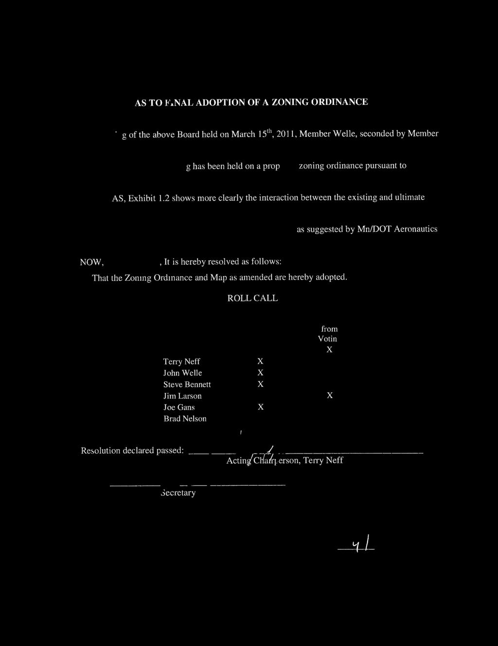
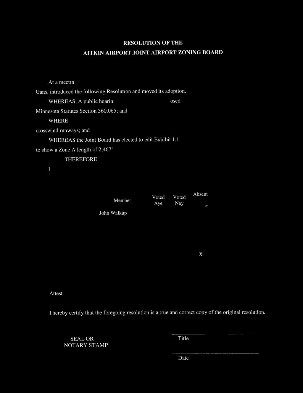
2 Table of Contents TITLE AND INTRODUCTION... 2 SECTION 1: PURPOSE AND AUTHORITY... 3 SECTION 2: SHORT TITLE... 4 SECTION 3: DEFINITIONS... 5 SECTION 4: AIR SPACE OBSTRUCTION ZONING... 7 SECTION 5: LAND USE SAFETY ZONING... 9 SECTION 6: AIRPORT MAP SECTION 7: PERFORMANCE STANDARDS SECTION 8: NONCONFORMING USES SECTION 9: PERMITS SECTION 10: VARIANCES SECTION 11: HAZARD MARKING AND LIGHTING SECTION 12: AIRPORT ZONING ADMINISTRATOR SECTION 13: BOARD OF ADJUSTMENT SECTION 14: APPEALS SECTION 15: JUDICIAL REVIEW SECTION 16: PENALTIES SECTION 17: CONFLICTS SECTION 18: SEVERABILITY SECTION 19: EFFECTIVE DATE EXHIBIT A EXHIBIT 1.1 LAND USE SAFETY ZONES MAP EXHIBIT 1.2 LAND USE SAFETY ZONES RUNWAY 8-26 EXHIBIT 2.1 AIRSPACE MAP EXHIBIT AIRSPACE MAP NORTH APPROACH EXHIBIT AIRSPACE MAP SOUTH APPROACH Aitkin Airport Zoning Ordinance 1 of 20
3 TITLE AND INTRODUCTION AITKIN AIRPORT ZONING ORDINANCE AITKIN AIRPORT JOINT AIRPORT ZONING BOARD AN ORDINANCE REGULATING AND RESTRICTING THE HEIGHT OF STRUCTURES AND OBJECTS OF NATURAL GROWTH, AND OTHERWISE REGULATING THE USE OF PROPERTY, IN THE VICINITY OF THE AITKIN AIRPORT BY CREATING THE APPROPRIATE ZONES AND ESTABLISHING THE BOUNDARIES THEREOF; PROVIDING FOR CHANGES IN THE RESTRICTIONS AND BOUNDARIES OF SUCH ZONES; DEFINING CERTAIN TERMS USED HEREIN; REFERRING TO THE AITKIN AIRPORT ZONING EXHIBITS WHICH ARE INCORPORATED IN AND MADE A PART OF THIS ORDINANCE; PROVIDING FOR ENFORCEMENT; ESTABLISHING A BOARD OF ADJUSTMENT; AND IMPOSING PENALTIES. IT IS HEREBY ORDAINED BY THE AITKIN AIRPORT JOINT AIRPORT ZONING BOARD PURSUANT TO THE AUTHORITY CONFERRED BY MINNESOTA STATUTES SECTION THROUGH , AS FOLLOWS: Aitkin Airport Zoning Ordinance 2 of 20
4 SECTION 1: PURPOSE AND AUTHORITY The Aitkin Airport Joint Airport Zoning Board, created and established by joint action of the City Council of the City of Aitkin and the Board of Commissioners of Aitkin County, and the Town Board of Spencer Township pursuant to the provisions and authority of Minnesota Statutes Section , hereby finds and declares that: A. An airport hazard endangers the lives and property of users of the Aitkin Airport, and property or occupants of land in its vicinity; and also if of the obstructive type, in effect reduces the size of the area available for the landing, takeoff, and maneuvering of aircraft, thus tending to destroy or impair the utility of said Airport and the public investment therein. B. The creation or establishment of an airport hazard is a public nuisance and an injury to the region served by the Aitkin Airport. C. For the protection of the public health, safety, order, convenience, prosperity, and general welfare, and for the promotion of the most appropriate use of land, it is necessary to prevent the creation or establishment of airport hazards. D. The prevention of these airport hazards should be accomplished, to the extent legally possible, by the exercise of the police power without compensation. E. The prevention of the creation or establishment of airport hazards, and the elimination, removal, alteration, mitigation, or marking and lighting of existing airport hazards are public purposes for which political subdivisions may raise and expend public funds. F. The Aitkin Airport is an essential public facility that serves an important public transportation role and provides a public good. G. Section 6 of the Aitkin City Code establishes the Airport Zoning Overlay District to better manage significant areas with specific needs that cross Zoning District Boundaries All sites within an overlay district shall continue to bear their original zoning, but shall also comply with the provisions of the overlay district appended. (Section 6.1.A). City ordinance recognizes that Overlay (Airport Zoning) Maps are considered part of the official Zoning Map and all land uses must comply with the provisions of the applicable overlay district. H. Section 21 of the Aitkin County Zoning Ordinance recognizes the Airport Zoning Ordinance to promote public health, safety, and general welfare and to protect the lives and property of users of the Aitkin County Airports and of the owners and occupants of land in their vicinities. (Section 21.01) I. The Aitkin County Comprehensive Land Use Plan recognizes the importance of Aviation industry to the community and recommends that the County: Support continued development and maintenance of the airport system serving the County Aitkin Airport Zoning Ordinance 3 of 20
5 Work with each city or airport manager to assure plans are developed to reserve space for future airport expansion Assure that zoning districts surrounding existing airports are compatible with airport use and expansion and have adequate space for associated business development. J. This Ordinance Amends and replaces Aitkin Airport Zoning Ordinance adopted May, SECTION 2: SHORT TITLE This Ordinance shall be known as the Aitkin Airport Zoning Ordinance. Those sections of land affected by this Ordinance are indicated in Exhibit A, which is attached to this Ordinance. Aitkin Airport Zoning Ordinance 4 of 20
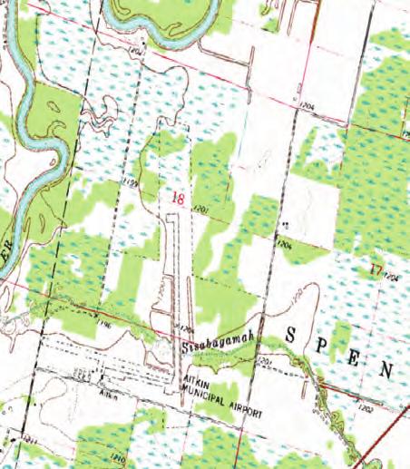
6 SECTION 3: DEFINITIONS As used in this Ordinance, unless the context otherwise requires: AIRPORT means the Aitkin Airport located in Sections 18 and 19, Township 47 North, Range 26 West. AIRPORT ELEVATION means the established elevation of the highest point on the usable landing area which elevation is established to be 1,206 feet above mean sea level. AIRPORT HAZARD means any structure, tree, or use of land which obstructs the air space required for, or is otherwise hazardous to, the flight of aircraft in landing or taking off at the airport; and any use of land which is hazardous to persons or property because of its proximity to the airport. AITKIN AIRPORT COMMISSION refers to a five member commission with the authority to make decisions on the Aitkin Airport which is funded two-thirds by Aitkin County and one-third by the City of Aitkin. COMMISSIONER means the Commissioner of the Minnesota Department of Transportation. CONFORMING USE means any structure, tree, or object of natural growth, or use of land that complies with all the applicable provisions of this Ordinance or any amendment to this ordinance. DWELLING means any building or portion thereof designed or used as a residence or sleeping place of one or more persons. ESTABLISHED RESIDENTIAL NEIGHBORHOOD IN A BUILT UP URBAN AREA (ERN - BUUA) means an area which, if it existed on or before January 1, 1978 shall be considered a conforming use that shall not be prohibited. HEIGHT, for the purpose of determining the height limits in all zones set forth in this Ordinance and shown on the zoning map, the datum shall be mean sea level elevation unless otherwise specified. LANDING AREA means the area of the airport used for the landing, taking off, or taxiing of aircraft. LOW DENSITY RESIDENTIAL STRUCTURE means a single-family or two-family home. LOW DENSITY RESIDENTIAL LOT means a single lot located in an area which is zoned for singlefamily or two-family residences and in which the predominant land use is such type of residences. NONCONFORMING USE means any pre-existing structure, tree, natural growth, or land use which is inconsistent with the provisions of this Ordinance or an amendment hereto. NONPRECISION INSTRUMENT RUNWAY means a runway having an existing or planned straight-in instrument approach procedure utilizing air navigation facilities with only horizontal guidance, and for which no precision approach facilities are planned or indicated on an approved planning document. OTHER THAN UTILITY RUNWAY means a runway that is constructed for and intended to be used by jet aircraft or aircraft of more than 12,500 pounds maximum gross weight; or is 4,900 feet or more in length. Aitkin Airport Zoning Ordinance 5 of 20
7 PERSON means an individual, firm, partnership, corporation, company, association, joint stock association, or body politic, and includes a trustee, receiver, assignee, administrator, executor, guardian, or other representative. PLANNED, as used in this Ordinance, refers only to those proposed future airport developments that are so indicated on a planning document having the approval of the Federal Aviation Administration, Minnesota Department of Transportation Office of Aeronautics and the Aitkin Airport Commission. PRECISION INSTRUMENT RUNWAY means a runway having an existing instrument approach procedure utilizing an Instrument Landing System (ILS), a Microwave Landing System (MLS), or a Precision Approach Radar (PAR), a Transponder Landing System (TLS), or a satellite-based system capable of operating to the same level of precision guidance provided by the other included systems. Also, a runway for which a precision instrument approach system is planned and is so indicated on an approved planning document. RUNWAY means any existing or planned paved surface or turf covered area of the airport which is specifically designated and used or planned to be used for the landing and/or taking off of aircraft. SLOPE means an incline from the horizontal expressed in an arithmetic ratio of horizontal magnitude to vertical magnitude. Slope = 3:1 = 3 feet horizontal to 1 foot vertical STRUCTURE means an object constructed or installed by man, including, but without limitations, buildings, towers, smokestacks, earth formations, and overhead transmission lines. TRAVERSE WAYS, for the purpose of determining height limits as set forth in this Ordinance, shall be increased in height by 17 feet for interstate highways; 15 feet for all other public roadways; 10 feet or the height of the highest mobile object that would normally traverse the road, whichever is greater, for private roads; 23 feet for railroads; and for waterways and all other traverse ways not previously mentioned, an amount equal to the height of the highest mobile object that would normally traverse it. TREE means any object of natural growth. UTILITY RUNWAY means a runway that is constructed for, and intended to be used by propeller-driven aircraft of 12,500 pounds maximum gross weight and less; and is less than 4,900 feet in length. VISUAL RUNWAY means a runway intended solely for the operation of aircraft using visual approach procedures, with no straight-in instrument approach procedure and no instrument designation indicated on an approved planning document. WATER SURFACES for the purpose of this ordinance, shall have the same meaning as land for the establishment of protected zones. Aitkin Airport Zoning Ordinance 6 of 20
8 SECTION 4: AIR SPACE OBSTRUCTION ZONING A. AIR SPACE ZONES: In order to carry out the purpose of this Ordinance, as set forth above, the following air space zones are hereby established: Primary Zone, Horizontal Zone, Conical Zone, Approach Zone, Precision Instrument Approach Zone, and Transitional Zone, and whose locations and dimensions are as follows: 1. PRIMARY ZONE: All that land which lies directly under an imaginary primary surface longitudinally centered on a runway and: a. Runway extends 200 feet beyond each end. b. Runway 8-26 Coincides with the 3,145 foot Visual Turf Runway 3,700 foot Non-Precision Bituminous Runway - extends 200 feet beyond each end. The elevation of any point on the primary surface is the same as the elevation of the nearest point on the runway centerline. The width of the primary surface is: a feet for Runway b. 556 feet to accommodate the combined surfaces of both the 3,145 foot Visual Turf Runway and the 3,700 foot Non-Precision Bituminous Runway. 2. HORIZONTAL ZONE: All that land which lies directly under an imaginary horizontal surface 150 feet above the established airport elevation, or a height of 1,356 feet above mean sea level, the perimeter of which is constructed by swinging arcs of specified radii from the center of each end of the primary surface of each runway and connecting the adjacent arcs by lines tangent to those arcs. The radius of the horizontal surface arc is 10,000 feet for Runway which encompasses the arc of the crosswind runway. 3. CONICAL ZONE: All that land which lies directly under an imaginary conical surface extending upward and outward from the periphery of the horizontal surface at a slope of 20:1 for a horizontal distance of 4,000 feet as measured outward from the periphery of the horizontal surface. 4. APPROACH ZONE: All that land which lies directly under an imaginary approach surface longitudinally centered on the extended centerline at each end of a runway. The inner edge of the Aitkin Airport Zoning Ordinance 7 of 20
9 approach surface is at the same width and elevation as, and coincides with, the end of the primary surface. The approach surface inclines upward and outward at a slope of a. 20:1 for the 3,145 foot Visual Turf Runway.- The approach surface expands uniformly to a width of 1,250 feet at a distance of 5,000 feet, then continues at the same rate of divergence to the periphery of the conical surface. b. 20:1 for the 3,700 foot Non-Precision Bituminous Runway. The approach surface expands uniformly to a width of 2,000 feet at a distance of 5,000 feet, then continues at the same rate of divergence to the periphery of the conical surface. 5. PRECISION INSTRUMENT APPROACH ZONE: All that land which lies directly under an imaginary precision instrument approach surface longitudinally centered on the extended centerline at each end of Runway 16-34, a precision instrument runway. The inner edge of the precision instrument approach surface is at the same width and elevation as, and coincides with, the end of the primary surface. The precision instrument approach surface inclines upward and outward at a slope of 50:1 for a horizontal distance of 10,000 feet expanding uniformly to a width of 4,000 feet, then continues upward and outward for an additional horizontal distance of 40,000 feet at a slope of 40:1, expanding uniformly to an ultimate width of 16,000 feet. 6. TRANSITIONAL ZONE: All that land which lies directly under an imaginary surface extending upward and outward at right angles to the runway centerline and centerline extended at a slope of 7:1 from the sides of the primary surfaces and from the sides of the approach surfaces until they intersect the horizontal surface or the conical surface. Transitional surfaces for those portions of the precision instrument approach surface which project through and beyond the limits of the conical surface, extend a distance of 5,000 feet measured horizontally from the edge of the precision instrument approach surface and at right angles to the extended precision instrument runway centerline. B. HEIGHT RESTRICTIONS: Except as otherwise provided in this Ordinance, and except as necessary and incidental to airport operations, no structure or tree shall be constructed, altered, maintained, or allowed to grow in any air space zone created in SECTION 4 A so as to project above any of the imaginary air space surfaces described in said SECTION 4 A hereof. Where an area is covered by more than one height limitation, the more restrictive limitation shall prevail. Aitkin Airport Zoning Ordinance 8 of 20
10 C. BOUNDARY LIMITATIONS: The air space obstruction height zoning restrictions set forth in this section shall apply for a distance not to exceed one and one half miles beyond the perimeter of the airport boundary and in that portion of an airport hazard area under the approach zone for a distance not exceeding two miles from the airport boundary. SECTION 5: LAND USE SAFETY ZONING A. SAFETY ZONE BOUNDARIES: In order to carry out the purpose of this Ordinance, as set forth above, to restrict those uses which may be hazardous to the operational safety of aircraft operating to and from the Aitkin Airport, and, furthermore, to limit population and building density in the runway approach areas, thereby creating sufficient open space to protect life and property in case of an accident, there are hereby created and established the following land use safety zones: 1. SAFETY ZONE A: All land in that portion of the approach zones of a runway, as defined in SECTION 4 A hereof, which extends outward from the end of the primary surface a distance equal to two-thirds of the planned length of the runway, which distance shall be: a. 3,334 feet for Runway b. 2,097 feet for the 3,145 foot Visual Turf Runway. c. 2,467 feet for the 3,700 foot Non-Precision Bituminous Runway. 2. SAFETY ZONE B: All land in that portion of the approach zones of a runway, as defined in SECTION 4 A hereof, which extends outward from Safety Zone A a distance equal to onethird of the planned length of the runway, which distance shall be: a. 1,666 feet for Runway b. 1,048 feet for the 3,145 foot Visual Turf Runway.. c. 1,233 feet for the 3,700 foot Non-Precision Bituminous Runway. 3. SAFETY ZONE C: All land which is enclosed within the perimeter of the horizontal zone, as defined in SUBSECTION 4 A hereof, and which is not included in Safety Zone A or Safety Zone B. 4. EXCEPTIONS ESTABLISHED RESIDENTIAL NEIGHBORHOODS: There are no areas designated as Established Residential Neighborhoods in Built up Urban Areas based upon the status of development existing on January 1, Aitkin Airport Zoning Ordinance 9 of 20
11 B. USE RESTRICTIONS: 1. GENERAL: Subject at all times to the height restrictions set forth in SECTION 4 B, no use shall be made of any land in any of the safety zones defined in SECTION 5 A which creates or causes interference with the operations of radio or electronic facilities on the airport or with radio or electronic communications between the airport and aircraft, make it difficult for pilots to distinguish between airport lights and other lights, results in glare in the eyes of pilots using the airport, impairs visibility in the vicinity of the airport, or otherwise endangers the landing, taking off, or maneuvering of aircraft. 2. ZONE A: Subject at all times to the height restrictions set forth in Subsection 4 B and to the general restrictions contained in Subsection 5 B 1, areas designated as Zone A shall contain no buildings, temporary structures, exposed transmission lines, or other similar above-ground land use structural hazards, and shall be restricted to those uses which will not create, attract, or bring together an assembly of persons thereon. Permitted uses may include, but are not limited to, such uses as agriculture (seasonal crops), horticulture, animal husbandry, raising of livestock, light outdoor recreation (non-spectator), cemeteries, and automobile parking without lighting or other above ground structures. 3. ZONE B: Subject at all times to the height restrictions set forth in Subsection 4 B, and to the general restrictions contained in Subsection 5 B 1, areas designated as Zone B shall be restricted in use as follows: a. Each use shall be on a site whose area shall not be less than three acres. b. Each use shall not create, attract, or bring together a site population that would exceed 15 times that of the site acreage c. Each site shall have no more than one building plot upon which any number of structures may be erected. d. A building plot shall be a single, uniform, and non-contrived area, whose shape is uncomplicated and whose area shall not exceed the following minimum ratios with respect to the total site area: Aitkin Airport Zoning Ordinance 10 of 20
12 At least (acres) Site Area But Less Than (acres) Ratio of Building Site Area to Bldg. Plot Area Max. Site Plot Area (sq. ft.) Population (15 persons/acre) :1 10, :1 17, :1 32, :1 72, and up 4:1 218, e. The following uses are specifically prohibited in Zone B: churches, hospitals, schools, theaters, stadiums, hotels, motels, trailer courts, campgrounds, and other places of frequent public or semi-public assembly. 4. ZONE C: Zone C is subject only to height restrictions set forth in SECTION 4 B, and to the general restrictions contained in SECTION 5 B EXEMPTIONS ESTABLISHED RESIDENTIAL NEIGHBORHOODS There are no areas designated as Established Residential Neighborhoods in Built up Urban Areas based upon the status of development existing on January 1, C. BOUNDARY LIMITATIONS: The land use zoning restrictions set forth in this section shall apply for a distance not to exceed one mile beyond the perimeter of the airport boundary and in that portion of an airport hazard area under the approach zone for a distance not exceeding two miles from the airport boundary. D. BOUNDARY ASSURANCES: A certified survey prepared by a licensed land surveyor shall be required to be submitted with a building/zoning permit application for properties that are entirely or partially contained within Land Use Safety Zones A and B, unless the Zoning Administrator determines the proposed building site is clearly outside said Safety Zones. For any location within the air space jurisdiction of this ordinance, the Zoning Administrator may require a survey that shows the elevation of a proposed structure will conform to the air space requirements of this ordinance. Aitkin Airport Zoning Ordinance 11 of 20
13 SECTION 6: AIRPORT MAP The several zones herein established are shown in Exhibit 1.1 Land Use Safety Zones Map, Exhibit 1.2 Land Use Safety Zone Runway 8-26, Exhibit 2.1 Airspace Map, 2.2 Airspace Map North Approach and Exhibit 2.3 Airspace Map South Approach have been prepared by Bolton & Menk, Inc., and dated 9/30/2010 (Land Use exhibits) and 11/16/2010 (Airspace exhibits), said exhibits are attached hereto and made a part hereof, which, together with such amendments thereto as may from time to time be made, and all notations, references, elevations, data, zone boundaries, and other information thereon, shall be and the same is hereby adopted as part of this Ordinance. Refer to the local land use authority for underlying land use and zoning designations, as well as Section 17 for guidance on conflicts between regulations. SECTION 7: PERFORMANCE STANDARDS To avoid the creation of a use that may have adverse impacts on overhead flight or to persons or property on the ground, no land use within the airport s proximity, regardless whether permitted under the applicable airport zoning regulations, can operate or perform in a way that exceeds the following performance standard limits. 1. Is tall enough to be hazardous to the navigation of aircraft, including tall buildings, smokestacks, construction cranes, trees, cell towers and Wind Energy Conversion Systems. 2. May interfere with electronic navigation aids such as radar facilities and instrument landing systems that provide for the safe movement of aircraft. These aides may be located on-airport or off. Non-aviation electronic sources placed near electronic navigation aids may cause interference. Similarly, new structures may block the navigation aid signals. Both these types of situations must be reviewed prior to the placement of such uses and structures. 3. May cause a visual distraction to pilots approaching the airport. Distractions can occur from outdoor lights near an airport (e.g., high mast lighting or stadium lighting), from highly reflective exterior building materials, or from water surfaces. Smoke or steam generated by nearby businesses, industry, or field burning can also create severe visual difficulties for pilots. Activities that generate a lot of dust can cause similar problems. 4. Is deemed to have the potential to create a wildlife hazard to airport operations as determined by the Federal Aviation Administration (FAA), U.S. Department of Agriculture (USDA), U.S. Fish and Wildlife Services (USFWS) and Mn/DOT Aeronautics. Aitkin Airport Zoning Ordinance 12 of 20
14 SECTION 8: NONCONFORMING USES Regulations not retroactive. The regulations prescribed by this Ordinance shall not be construed to require the removal, lowering, or other changes or alteration of any structure or tree not conforming to the regulations as of the effective date of this Ordinance, or otherwise interfere with the continuance of any nonconforming use. Nothing herein contained shall require any change in the construction, alteration, or intended use of any structure, the construction or alteration of which was begun prior to the effective date of this Ordinance, and is diligently prosecuted and completed within two years thereof. SECTION 9: PERMITS A. FUTURE USES: Except as specifically provided in Paragraphs 1 and 2 hereunder, no material change shall be made in the use of land and no structure shall be erected, altered, or otherwise established in any zone hereby created unless a permit therefore shall have been applied for and granted by the Zoning Administrator, hereinafter, provided for. Each application for a permit shall indicate the purpose for which the permit is desired, with sufficient particularity to permit it to conform to the regulations herein prescribed. If such determination is in the affirmative, the permit shall be granted. 1. However, a permit for a tree or structure of less than 75 feet of vertical height above the ground shall not be required in the horizontal and conical zones or in any approach and transitional zones beyond a horizontal distance of 4,200 feet from each end of the runway except when such tree or structure, because of terrain, land contour, or topographic features, would extend the height or land use limit prescribed for the respective zone. 2. Nothing contained in this foregoing exception shall be construed as permitting or intending to permit any construction, alteration, or growth of any structure or tree in excess of any of the height limitations established by this ordinance as set forth in SECTION 4 and the land use limitations set forth in SECTION 5. B. EXISTING USES: Before any existing use or structure may be replaced, substantially altered or repaired, or rebuilt within any zone established herein, a permit must be secured authorizing such replacement, change, or repair. No permit shall be granted that would allow the establishment or creation of an airport hazard or permit a nonconforming use, structure, or tree to become a greater hazard to air navigation than it was on the effective date of this Ordinance or any amendments thereto, or than it is when the application for a permit is made. Except as indicated, all applications for such a permit shall be granted. Aitkin Airport Zoning Ordinance 13 of 20
15 C. NONCONFORMING USES ABANDONED OR DESTROYED: Whenever the Zoning Administrator determines that a nonconforming structure or tree has been abandoned or more than 80% torn down, deteriorated, or decayed, no permit shall be granted that would allow such structure or tree to exceed the applicable height limit or otherwise deviate from the zoning regulations. Whether application is made for a permit under this paragraph or not, the Zoning Administrator may order the owner of the abandoned or partially destroyed nonconforming structure, at his own expense, to lower, remove, reconstruct, or equip the same in the manner necessary to conform to the provisions of this Ordinance. In the event the owner of the nonconforming structure shall neglect or refuse to comply with such order for ten days after receipt of written notice of such order, the Zoning Administrator may, by appropriate legal action, proceed to have the abandoned or partially destroyed nonconforming structure lowered, removed, reconstructed, or equipped and assess the cost and expense thereof against the land on which the structure is or was located. Unless such an assessment is paid within ninety days from the service of notice thereof on the owner of the land, the sum shall bear interest at the rate of eight percent per annum from the date the cost and expense is incurred until paid, and shall be collected in the same manner as are general taxes. SECTION 10: VARIANCES Any person desiring to erect or increase the height of any structure, permit the growth of any tree, or use his property not in accordance with the regulations prescribed in this Ordinance may apply to the Board of Adjustment, hereinafter provided for, for a variance from such regulations. If the Board of Adjustment fails to grant or deny the variance within the timeframe established within Minnesota State Statutes 15.99, the variance shall be deemed to be granted by the Board. When the variance is granted by reason of the failure of the Board to act on the variance, the person receiving the variance shall notify the Board and the Commissioner, by certified mail, that the variance has been granted. The applicant shall include a copy of the original application for the variance with this notice to the Commissioner. The variance shall be effective sixty days after this notice is received by the Commissioner subject to any action taken by the Commissioner pursuant to Minnesota Statutes Section , Subdivision 6a. Such variances shall be allowed where it is duly found that a literal application or enforcement of the regulations would result in practical difficulty or unnecessary hardship, and relief granted would not be contrary to the public interest but do substantial justice and be in accordance with the spirit of this Ordinance provided any variance so allowed may be subject to any reasonable conditions that the Board or Commissioner may deem necessary to effectuate the purpose of this Ordinance. Aitkin Airport Zoning Ordinance 14 of 20
16 The respective Zoning Administrator shall forward the request to the Minnesota Department of Transportation Office of Aeronautics and the other jurisdiction s Zoning Administrator for review and comment prior to consideration of the request by the Board of Adjustment. SECTION 11: HAZARD MARKING AND LIGHTING A. NONCONFORMING USES: The owner of any nonconforming structure or tree is hereby required to permit the installation, operation, and maintenance thereon of such markers and lights as shall be deemed necessary by the Zoning Administrator, to indicate to the operators of aircraft in the vicinity of the airport the presence of such airport hazards. Such markers and lights shall be installed, operated, and maintained at the expense of the Aitkin Airport Commission. B. PERMITS AND VARIANCES: Any permit or variance deemed advisable to effectuate the purpose of this Ordinance and be reasonable in the circumstances, and granted by the Zoning Administrator or Board, shall require the owner of the structure or tree in question, at his own expense, to install, operate, and maintain thereon such markers and lights as may be necessary to indicate to pilots the presence of an airport hazard. SECTION 12: AIRPORT ZONING ADMINISTRATOR It shall be the duty of the City of Aitkin and Aitkin County Zoning Administrators to administer and enforce the regulations prescribed herein, based on the area in which they have land use authority. Applications for permits and variances shall be made to the appropriate jurisdiction s Zoning Administrator upon a form furnished by them. Permit applications shall be promptly considered and granted or denied by them in accordance with the regulations prescribed herein or as provided for within Minnesota State Statutes Variance applications shall be forthwith transmitted by the appropriate jurisdiction s Zoning Administrator to the Board of Adjustment for action as hereinafter provided for. SECTION 13: BOARD OF ADJUSTMENT A. ESTABLISHMENT: The Board of Adjustment for the Aitkin Airport Zoning Ordinance shall exclude elected officials and be defined as follows: 1. City of Aitkin Planning Commission for requests in the corporate City limits or within the boundary of an orderly annexation agreement area. 2. Aitkin County Board of Adjustment for other requests in the unincorporated area. If elected officials serve on a Board of Adjustment, they shall abstain from voting. Aitkin Airport Zoning Ordinance 15 of 20
17 B. POWERS: The Board of Adjustment shall have and exercise the following powers: 1. Hear and decide appeals from any order, requirement, decision, or determination made by the administrator in the enforcement of this Ordinance. 2. Hear and decide special exceptions to the terms of this Ordinance upon which such Board of Adjustment under such regulations may be required to pass. 3. Hear and decide specific variances. C. PROCEDURES: 1. A request for a variance or an appeal to the Zoning Administrator s ruling shall be filed with the Zoning Administrator. The respective Zoning Administrator shall forward the request to the Minnesota Department of Transportation Office of Aeronautics and the other jurisdiction s Zoning Administrator for review and comment prior to consideration of the request by the Board of Adjustment. 2. Rules governing the Board of Adjustment shall be consistent with those established by the body serving as the Board of Adjustment and the provisions of this Ordinance. Meetings of the Board of Adjustment shall be held at the call Zoning Administrator or chairperson and at such other times as the Board of Adjustment may determine. The chairperson, or in his absence the acting chairperson, may administer oaths and compel the attendance of witnesses. All hearings of the Board of Adjustment shall be public. The Board of Adjustment shall keep minutes of its proceedings showing the vote of each member upon each question or, if absent or failing to vote, indicating such fact, and shall keep records of its examinations and other official actions, all of which shall immediately be filed in the offices of both Zoning Administrators and the County Recorder s Office and shall be a public record. 3. The Board of Adjustment shall make written findings of facts and conclusions of law giving the facts upon which it acted and its legal conclusions from such facts in reversing, affirming, or modifying any order, requirement, decision, or determination which comes before it under the provisions of this ordinance. 4. The concurring vote of a majority of the members of the Board of Adjustment shall be sufficient to reverse any order, requirement, decision, or determination of the Zoning Administrator or to decide in favor of the applicant on any matter upon which it is required to pass under this Ordinance, or to effect any variation in this Ordinance. Aitkin Airport Zoning Ordinance 16 of 20
18 SECTION 14: APPEALS A. Any person aggrieved, or any taxpayer affected by any decision of the Zoning Administrator made in his administration of this Ordinance may appeal to the Board of Adjustment. Such appeals may also be made by any governing body of a municipality, county, or airport zoning board, which is of the opinion that a decision of the Zoning Administrator is an improper application of this Ordinance as it concerns such governing body or board. B. All appeals hereunder must be commenced within 30 days of the Zoning Administrator s decision, by filing with the Zoning Administrator a notice of appeal specifying the grounds thereof. The Zoning Administrator shall forthwith transmit to the Board of Adjustment all the papers constituting the record upon which the action appealed from was taken. In addition, any person aggrieved, or any taxpayer affected by any decisions of the Zoning Administrator made in his administration of this Ordinance who desires to appeal such decision shall submit an application for a variance, by certified mail, to the Zoning Administrator in the manner set forth in Minnesota Statutes Section , Subdivision 2. C. An appeal shall stay all proceedings in furtherance of the action appealed from, unless the Zoning Administrator certifies to the Board of Adjustment after the notice of appeal has been filed with it, that by reason of the facts stated in the certificate a stay would, in his opinion, cause imminent peril to life or property. In such case, proceedings shall not be stayed except by order of the Board of Adjustment on notice to the Zoning Administrator and on due cause shown. D. The Board of Adjustment shall fix a reasonable time for hearing appeals, give public notice and due notice to the parties in interest, and decide the same within a reasonable time. Upon the hearing, any party may appear in person, by agent, or by attorney. E. The Board of Adjustment may, in conformity with the provisions of this ordinance, reverse or affirm, in whole or in part, or modify the order, requirement, decision or determination appealed from and may make such order, requirement, decision or determination, as may be appropriate under the circumstances, and to that end shall have all the powers of the Zoning Administrator. Aitkin Airport Zoning Ordinance 17 of 20
19 SECTION 15: JUDICIAL REVIEW Any person aggrieved, or any taxpayer affected by any decision of the Board of Adjustment, or any governing body of a municipality, county, or airport zoning board, which is of the opinion that a decision of the Board of Adjustment is illegal may present to the District Court of Aitkin County a verified petition setting forth that the decision or action is illegal, in whole or in part, and specifying the grounds of the illegality. Such petition shall be presented to the court within 30 days after receipt of notice of the decision. The petitioner must exhaust the remedies provided in this Ordinance before availing himself of the right to petition a court as provided by this section. SECTION 16: PENALTIES Every person who shall construct, establish, substantially change, alter or repair any existing structure or use, or permit the growth of any tree without having complied with the provision of this Ordinance or who, having been granted a permit or variance under the provisions of this Ordinance, shall construct, establish, substantially change or substantially alter or repair any existing growth or structure or permit the growth of any tree, except as permitted by such permit or variance, shall be guilty of a misdemeanor. Each day a violation continues to exist shall constitute a separate offense. The airport Zoning Administrator may enforce all provisions of this Ordinance through such proceedings for injustice relief and other relief as may be proper under the laws of Minnesota Statutes Section and other applicable law. SECTION 17: CONFLICTS Where there exists a conflict between any of the regulations or limitations prescribed in this Ordinance and any other regulations applicable to the same area, whether the conflict be with respect to the height of structures or trees, the use of land, or any other matter, the more stringent limitation or regulation shall govern and prevail. SECTION 18: SEVERABILITY A. In any case in which the provision of this Ordinance, although generally reasonable, is held by a court to interfere with the use or enjoyment of a particular structure or parcel of land to such an extent, or to be so onerous in their application to such a structure or parcel of land, as to constitute a taking or deprivation of that property in violation of the constitution of this state or the constitution of the United States, such holding shall not affect the application of this Ordinance as to other structures and parcels of land, and to this end the provisions of this Ordinance are declared to be severable. Aitkin Airport Zoning Ordinance 18 of 20
20 B. Should any section or provision of this Ordinance be declared by the courts to be unconstitutional or invalid, such decision shall not affect the validity of the Ordinance as a whole or any part thereof other than the parts so declared to be unconstitutional or invalid. SECTION 19: EFFECTIVE DATE This ordinance shall take effect on the 9th day of April, 2011 Copies thereof shall be filed with the Commissioner through the Office of Aeronautics, State of Minnesota, and the Register of Deeds, Aitkin County, Minnesota. Passed and adopted after public hearing by the Aitkin Airport Joint Airport Zoning Board this 15 th day of March, Aitkin Airport Zoning Ordinance 19 of 20

21
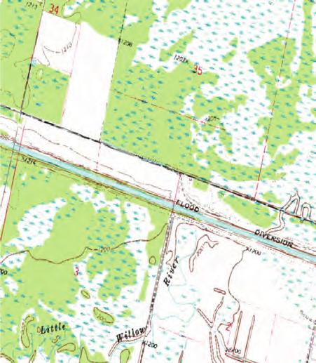
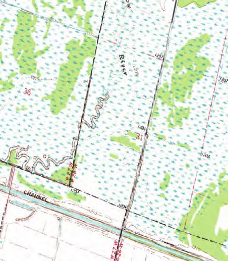
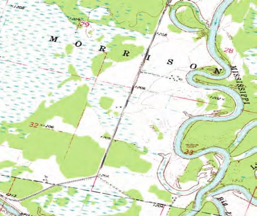
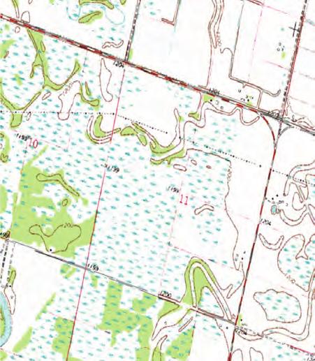
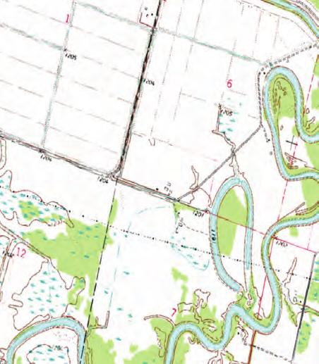
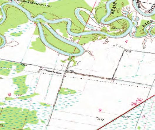
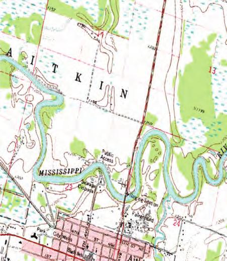
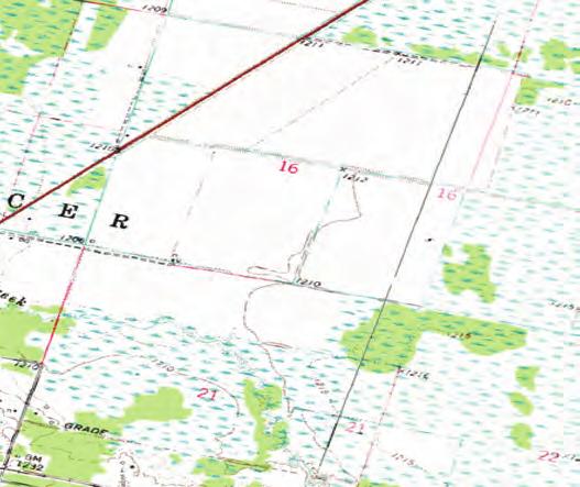
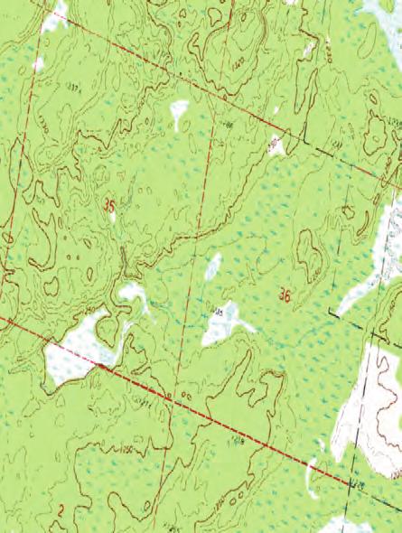
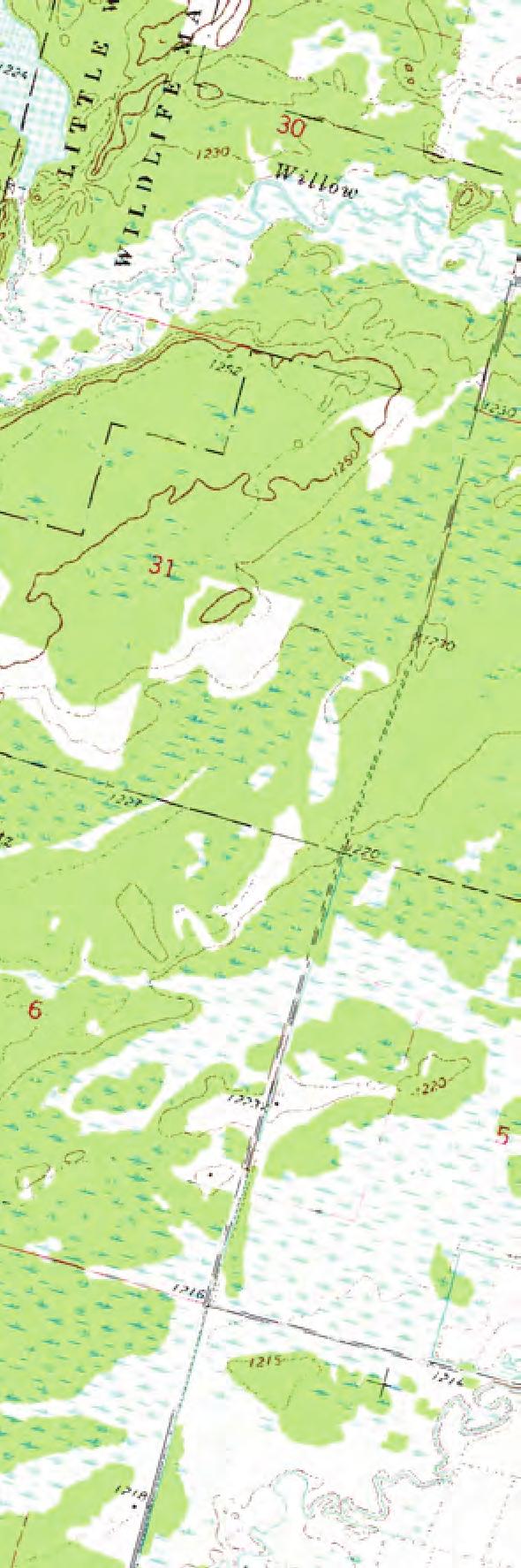
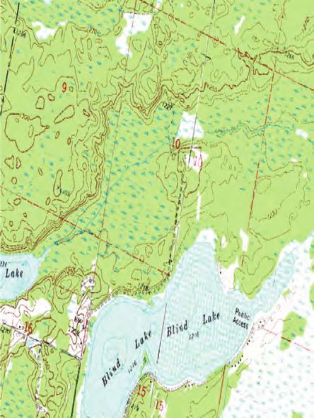
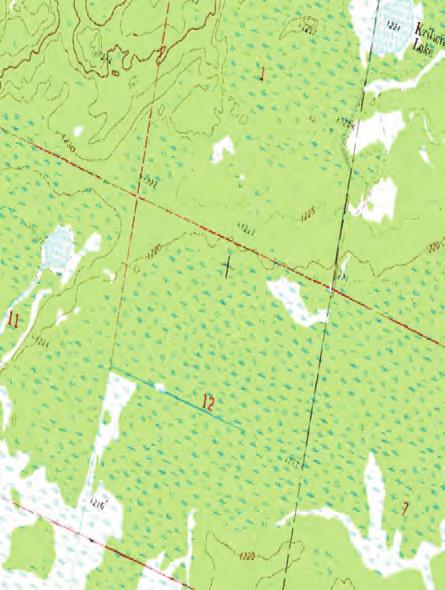
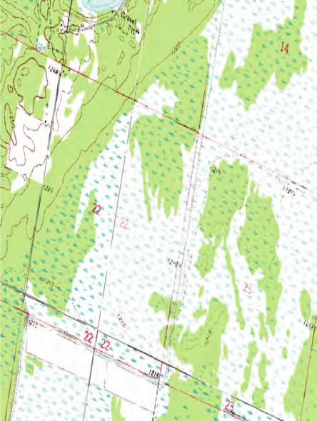
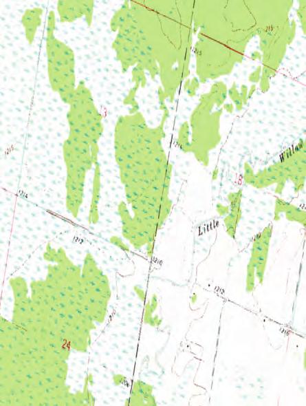
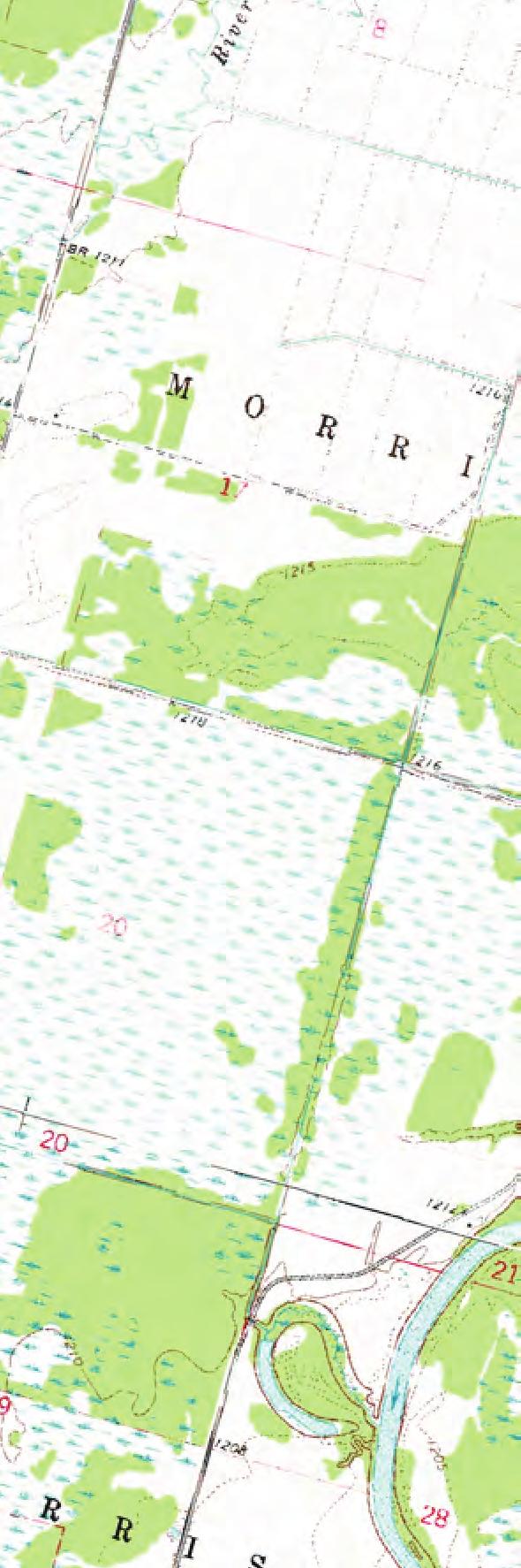
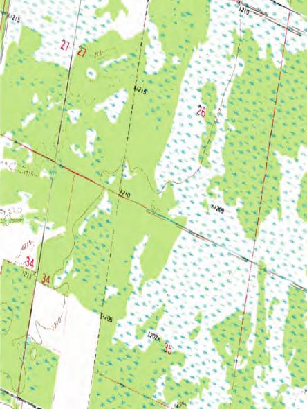
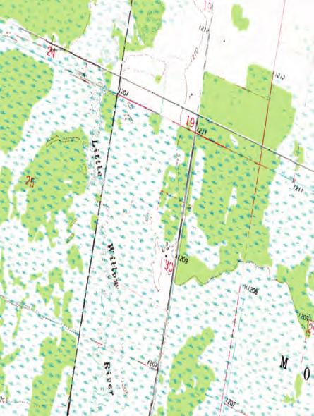
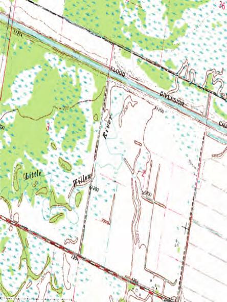
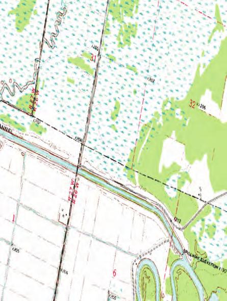
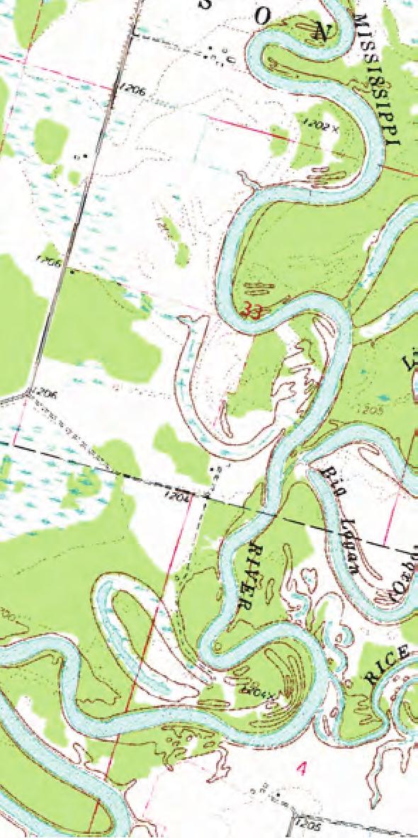
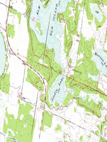
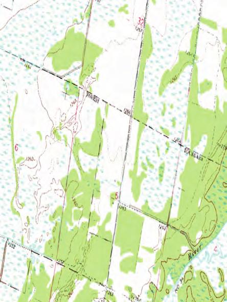
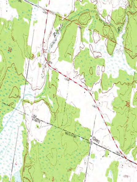
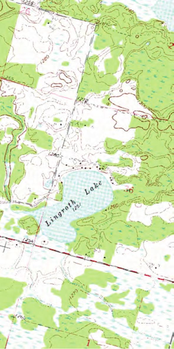
22 EXHIBIT A AITKIN AIRPORT ZONING ORDINANCE This Ordinance affects all or a portion of the following sections of land: AIR SPACE OBSTRUCTION ZONING: LAND USE SAFETY ZONING: NAME AND NUMBER Section 4 of Ordinance; Section 5 of Ordinance; Exhibit 3 - Air Space Map, Exhibit 3.2 Airspace Map - North Approach, Exhibit Airspace Map - South Approach Aitkin Township T47N R27W Sections:1, 2, 10, 11, 12, 13, 14, 15, 22, 23, 24, 25, 26, 35, 36 Exhibit Land Use Safety Zones Map and Exhibit Land Use Safety Zones Runway Sections: 1, 11, 12, 13, 14, 23, 24, 25, 36 Spencer Township T47N R26W Morrison Township T48N R26W Nordland Township T46N R26W Unorganized Township T48N R27W Wuakenabo Township T49N R26W Unorganized Township T49N R27W Farm Island Township T46N R27W Wealthwood Township T45N R26W Sections: 4, 5, 6, 7, 8, 9, 10, 15, 16, 17, 18, 19, 20, 21, 22, 27, 28, 29, 30, 31, 32, 33, Sections: 6, 7, 18, 19, 20, 29, 30, 31, 32 Sections: 3, 4, 5, 6, 7, 8, 9, 10, 14, 15, 16, 17, 18, 19, 20, 21, 22, 23,, 27, 28, 29, 30 Sections: 1, 2, 3, 10, 11, 12, 13, 14, 22, 23, 24, 25, 26, 35, 36 Sections: 31 Sections: 34, 35, 36 Sections: 1 Sections: 2, 3, 4, 5 Sections: 5, 6, 7, 8, 9, 16, 17, 18, 19, 20, 21, 28, 30, 31, 32 Sections: Sections: Sections: Sections: Sections: Sections: Sections: Aitkin Airport Zoning Ordinance 20 of 20

23 NOTE: 1. THIS MAP IS FOR ILLUSTRATIVE PURPOSES ONLY. ACTUAL LOCATION OF ZONING BOUNDARIES ON SPECIFIC PARCELS SHALL BE FIELD LOCATED BY A REGISTERED LAND SURVEY. 2. SEE EXHIBIT 1.2 FOR MORE INFORMATION ON RUNWAY

24 NOTE: 1. THIS MAP IS FOR ILLUSTRATIVE PURPOSES ONLY. ACTUAL LOCATION OF ZONING BOUNDARIES ON SPECIFIC PARCELS SHALL BE FIELD LOCATED BY A REGISTERED LAND SURVEY. 2. ALL ZONE A DIMENSIONS ARE FROM THE PRIMARY SURFACE OF EACH RUNWAY. 1.2

25
26

27

28
City of Winsted, Minnesota. Airport Zoning Ordinance. Winsted Municipal Airport
 CHAPTER 18 City of Winsted, Minnesota Airport Zoning Ordinance Winsted Municipal Airport September 25, 2002 18-1 Table of Contents Introduction... 18-4 Section I: Purpose and Authority... 18-5 Section
City of Winsted, Minnesota. Airport Zoning Ordinance. Winsted Municipal Airport
 CHAPTER 18 City of Winsted, Minnesota Airport Zoning Ordinance Winsted Municipal Airport September 25, 2002 18-1 Table of Contents Introduction... 18-4 Section I: Purpose and Authority... 18-5 Section
AIRPORT HAZARD ZONING ORDINANCE BRAZORIA COUNTY AIRPORT
 AIRPORT HAZARD ZONING ORDINANCE BRAZORIA COUNTY AIRPORT AN ORDINANCE REGULATING AND RESTRICTING THE HEIGHT OF STRUCTURES AND OBJECTS OF NATURAL GROWTH, AND OTHERWISE REGULATING THE USE OF PROPERTY, IN
Airport Safety Zoning Ordinance for
 Airport Safety Zoning Ordinance for the Le Sueur Municipal Airport (12Y) Adopted March 18, 2014 Approved by the Joint Airport Zoning Board This ordinance amends and replaces adopted January 1979. Table
Instructions to assist you in completing the Minnesota Model Airport Safety Zoning Ordinance.
 Instructions to assist you in completing the Minnesota Model Airport Safety Zoning Ordinance. We encourage you to call our staff before you begin the zoning process. It puts us on notice of your zoning
Appendix N HAZARD ZONING ORDINANCE/MAPS/ AIRPORTS ZONING MAPS. LAST UPDATED: May 1, 2001 CASE NUMBER: ORDINANCE NO.
 Appendix N HAZARD ZONING ORDINANCE/MAPS/ AIRPORTS LAST UPDATED: May 1, 2001 CASE NUMBER: ORDINANCE NO. Unified Development Code Grand Prairie, Texas Planning Department 7.2.1 Purpose The purpose of an
City of Montevideo, Minnesota. Airport Zoning Ordinance. Montevideo-Chippewa County Airport. Adopted March 13, 1984 and Revised October 10, 2006
 City of Montevideo, Minnesota Airport Zoning Ordinance Montevideo-Chippewa County Airport Adopted March 13, 1984 and Revised October 10, 2006 Table of Contents Introduction...1 Section I: Purpose And Authority...2
BRECKNOCK TOWNSHIP, BERKS COUNTY, PENNSYLVANIA ORDINANCE NO. 167
 BRECKNOCK TOWNSHIP, BERKS COUNTY, PENNSYLVANIA ORDINANCE NO. 167 AN ORDINANCE OF THE BOARD OF SUPERVISORS OF BRECKNOCK TOWNSHIP AMENDING THE BRECKNOCK TOWNSHIP ZONING ORDINANCE TO ADD A NEW SECTION 27-210
ORDINANCE TO LIMIT HEIGHT OF OBJECTS AND TO REGULATE PLACEMENT OF CERTAIN STRUCTURES WITHIN SPECIFIC AREAS OF NOISE LEVEL
 ORDINANCE TO LIMIT HEIGHT OF OBJECTS AND TO REGULATE PLACEMENT OF CERTAIN STRUCTURES WITHIN SPECIFIC AREAS OF NOISE LEVEL AROUND EASTERN WEST VIRGINIA REGIONAL AIRPORT REENACTMENT AND AMENDMENT OF BERKELEY
CHAPTER 7 AIRPORT HEIGHT ZONING OF SCOTT COUNTY/DAVENPORT AIRPORT
 SECTIONS: 7-1. TITLE 7-2. CONFLICTING REGULATIONS 7-3. DEFINITIONS 7-4. ZONES AND HEIGHT LIMITATIONS 7-5. NONCONFORMING USES 7-6. APPLICATIONS AND PERMITS 7-7. ENFORCEMENT 7-8. VARIANCES 7-9. DAVENPORT
(4) Airport hazard area means any area of land or water upon which an airport hazard might be established.
 Airport hazard area means any area of land or water upon which an airport hazard might be established.") New FS 333 CHAPTER 333 AIRPORT ZONING 333.01 Definitions. 333.02 Airport hazards and uses of land in airport vicinities contrary to public interest. 333.025 Permit required for obstructions. 333.03 Requirement
New FS 333 CHAPTER 333 AIRPORT ZONING 333.01 Definitions. 333.02 Airport hazards and uses of land in airport vicinities contrary to public interest. 333.025 Permit required for obstructions. 333.03 Requirement
ZONING ORDINANCE FOR THE TRI-COUNTY REGIONAL AIRPORT
 ZONING ORDINANCE FOR THE TRI-COUNTY REGIONAL AIRPORT Section 1 Statutory Authorization and Purpose.... 1 Section 2 Definitions.... 1 Section 3 General Provisions.... 2 Section 4 Airport Zones.... 3 Section
The 2006 Florida Statutes
 Page 1 of 15 Select Year: 2006 Go The 2006 Florida Statutes CHAPTER 333 AIRPORT ZONING 333.01 Definitions. 333.02 Airport hazards and uses of land in airport vicinities contrary to public interest. 333.025
CHAPTER 21 AIRPORT REGULATING HEIGHT OF STRUCTURES TREES AND PROPERTY
 CHAPTER 21 AIRPORT REGULATING HEIGHT OF STRUCTURES TREES AND PROPERTY 21.01 Definitions 21.02 Area of Jurisdiction 21.03 Activities Regulated 21.04 Nonconforming Use 21.05 Administration 21.06 Permits
BRAZORIA COUNTY ANGLETON - LAKE JACKSON JOINT AIRPORT ZONING BOARD COMPATIBLE LAND USE ZONING ORDINANCE NO. II
 BRAZORIA COUNTY ANGLETON - LAKE JACKSON JOINT AIRPORT ZONING BOARD COMPATIBLE LAND USE ZONING ORDINANCE NO. II AN ORDINANCE REGULATING AND RESTRICTING THE USE OF PROPERTY IN THE VICINITY OF THE BRAZORIA
Greg Jones Airspace and Land Use Manager (850)
") Florida Chapter 333, Airport Zoning Greg Jones Airspace and Land Use Manager (850) 414-4502 Aviation and Spaceports Office 605 Suwannee Street, MS 46 Tallahassee, FL 32399-0450 Greg.Jones@dot.state.fl.us
Florida Chapter 333, Airport Zoning Greg Jones Airspace and Land Use Manager (850) 414-4502 Aviation and Spaceports Office 605 Suwannee Street, MS 46 Tallahassee, FL 32399-0450 Greg.Jones@dot.state.fl.us
TUSCOLA AREA AIRPORT ZONING ORDINANCE
 TUSCOLA AREA AIRPORT ZONING ORDINANCE ADOPTED BY THE TUSCOLA COUNTY BOARD OF COMMISSIONERS UNDER THE AUTHORITY OF IN COMPLIANCE WITH PA110 OF 2006 COUNTY ORDINANCE # 01-2010 ORDINANCE ADMINISTRATED BY:
ORDINANCE NO. _--,9,--_ THE COUNTY BOARDS OF THE COUNTIES OF IOWA, RICHLAND AND SAUK, WISCONSIN, DO ORDAIN AS FOLLOWS:
 ORDINANCE NO. _--,9,--_ REGULATING THE HEIGHT OF STRUCTURES AND TREES IN THE VICINITY OF THE TRI COUNTY REGIONAL AIRPORT, LONE ROCK, SAUK COUNTY, WISCONSIN. THE COUNTY BOARDS OF THE COUNTIES OF IOWA, RICHLAND
DUPLIN COUNTY AIRPORT AIRPORT LAND USE AND HEIGHT RESTRICTION ORDINANCE
 DUPLIN COUNTY AIRPORT AIRPORT LAND USE AND HEIGHT RESTRICTION ORDINANCE PREPARED BY: THE DUPLIN COUNTY PLANNING BOARD AND THE DUPLIN COUNTY AIRPORT COMMISSION EFFECTIVE: MAY 1, 2009 ENACTMENT PREAMBLE
Iowa County Airport Zoning Ordinance
 Ordinance No. 400.16 Iowa County Airport Zoning Ordinance Iowa County, Wisconsin Copies are available at the Office of Planning & Development 222 N. Iowa Street Dodgeville, WI 53533 (608) 935-0398 www.iowacounty.org
ORDINANCE FOR PRIVATE USE HELICOPTERS SECTION 1
 ORDINANCE FOR PRIVATE USE HELICOPTERS SECTION 1 SHORT TITLE: This Ordinance shall be known and may be cited as Ordinance for Heliports. SUMMARY: Helicopter landings, take-offs, and hovering are prohibited
ARTICLE IV ADMINISTRATION
 Highlighted items in bold and underline font are proposed to be added. Highlighted items in strikethrough font are proposed to be removed. CHAPTER 4.01. GENERAL. Section 4.01.01. Permits Required. ARTICLE
TOWN OF ST. GERMAIN P. O. BOX 7 ST. GERMAIN, WI 54558
 TOWN OF ST. GERMAIN P. O. BOX 7 ST. GERMAIN, WI 54558 www.townofstgermain.org Minutes, Zoning Committee March 06, 2019 1. Call to order: Chairman Ritter called meeting to order at 5:30pm 2. Roll call,
NC General Statutes - Chapter 63 1
 Chapter 63. Aeronautics. Article 1. Municipal Airports. 63-1. Definitions; singular and plural. (a) Definitions. For the purpose of this Chapter the following words, terms, and phrases shall have the meanings
ARTICLE 15 ADMINISTRATIVE PROCEDURE AND ENFORCEMENT
 ARTICLE 15 ADMINISTRATIVE PROCEDURE AND ENFORCEMENT Section 1501 Brule County Zoning Administrator An administrative official who shall be known as the Zoning Administrator and who shall be designated
ARTICLE XIV ZONING BOARD OF APPEALS
 --------~ -~----- ------------------------------------------------- A. Purpose and Intent ARTICLE XIV ZONING BOARD OF APPEALS The purpose of this Article is to provide for the creation of a Zoning Board
MUNICIPALITY OF MONROEVILLE ALLEGHENY COUNTY, PENNSYLVANIA ORDINANCE NO. 2553
 MUNICIPALITY OF MONROEVILLE ALLEGHENY COUNTY, PENNSYLVANIA ORDINANCE NO. 2553 AN ORDINANCE OF THE COUNCIL OF THE MUNICIPALITY OF MONROEVILLE, ALLEGHENY COUNTY, PENNSYLVANIA, AMENDING ORDINANCE NO. 1443,
TITLE 18 - Signs and Related Regulations
 TITLE 18 - Signs and Related Regulations CHAPTER 18.01 GENERAL PROVISIONS 18.01.010 Title 18.01.020 Purpose 18.01.030 Compliance with Title Provisions 18.01.040 Interpretation 18.01.050 Relationship to
Ashe County, NC Ordinance Chapter 163: Regulation of Wind Energy Systems
 Ashe County, NC Ordinance Chapter 163: Regulation of Wind Energy Systems Section 1 Authority and Purpose Inasmuch as Ashe County has determined that certain windmills are possibly exempt under the North
ORDINANCE NO WHEREAS, by act of the General Assembly of Virginia as codified by Chapter 11,
 ORDINANCE NO. 640 AN ORDINANCE REGULATING AND RESTRICTING THE USE OF LAND AND THE USE AND LOCATION OF BUILDINGS AND STRUCTURES; REGULATING AND RESTRICTING THE HEIGHT AND BULK OF BUILDINGS AND STRUCTURES
SECTION 9. FEEDLOT REGULATIONS
 SECTION 9. FEEDLOT REGULATIONS Subsection 9.1: Statutory Authorization, Policy & General Provisions A. Statutory Authorization. The Swift County Feedlot Regulations are adopted pursuant to the authorization
PIKE TOWNSHIP, OHIO July 6, 2010 ZONING REGULATIONS
 CHAPTER 6 - SIGN AND BILLBOARD REGULATIONS Section A - Permitted Signs for Which No Certificate is Required The following signs shall be permitted in the unincorporated area of Pike Township that is subject
ARTICLE I Enactment & Application. ARTICLE III Boundary Regulations. ARTICLE IV Manufactured Housing Requirements. ARTICLE V Nonconforming Uses
 8-16-2016 1 2 3 4 Title. Enactment; Authority. Purpose. Application of Regulations. 1 Word Usage. 2 Definitions. Land Use ARTICLE I Enactment & Application ARTICLE II Terminology 1 Minimum Lot Sizes. 2
ARTICLE 7 WIRELESS TELECOMMUNICATIONS TOWERS AND FACILITIES
 ARTICLE 7 WIRELESS TELECOMMUNICATIONS TOWERS AND FACILITIES ARTICLE 7 WIRELESS TELECOMMUNICATIONS TOWERS AND FACILITIES 7.00 Purpose 7.04 Fees 7.01 Permitted Uses 7.05 Public Utility Exemption 7.02 Conditional
A. Preserve and enhance Pottstown s traditional town character, protect its historic resources, and revitalize its older areas.
 APPENDIX A1 Purpose SECTION A100 General Purpose The intent of this Article is to establish a precise and detailed plan for the use of land in the Borough, and it is enacted to promote and to protect the
(JULY 2000 EDITION, Pub. by City of LA) Rev. 9/13/
 Rev. 9/13/") Sec. 12.24 SEC. 12.24 -- CONDITIONAL USE PERMITS AND OTHER SIMILAR QUASI- JUDICIAL APPROVALS. (Amended by Ord. No. 173,268, Eff. 7/1/00.) A. Applicability. This section shall apply to the conditional use
Sec. 12.24 SEC. 12.24 -- CONDITIONAL USE PERMITS AND OTHER SIMILAR QUASI- JUDICIAL APPROVALS. (Amended by Ord. No. 173,268, Eff. 7/1/00.) A. Applicability. This section shall apply to the conditional use
Section 3. Compliance with County and Appalachian Board of Health Rules.
 STATE OF NORTH CAROLINA COUNTY OF WATAUGA WATAUGA COUNTY MANUFACTURED HOME PARKS ORDINANCE Section 1. Authority and Purpose. Pursuant to the authority granted to counties in North Carolina General Statute
CITY ORDINANCE NO. 585
 CITY ORDINANCE NO. 585 AN ORDINANCE OF THE CITY OF ABERNATHY AMENDING ORDINANCE 310 (ZONING CODE) OF THE CITY OF ABERNATHY AND REPEALING ALL LAWS OR ORDINANCES OR PARTS OF ORDINANCES IN CONFLICT THEREWITH;
209/213 South Seventh Street Substandard Lot Variance
 209/213 South Seventh Street Substandard Lot Variance Background: Steven Schmidt owns both parcels, 209 & 213 South Seventh Street. Steven Schmidt is looking to move 209 South Seventh Street s property
MERCER COUNTY ZONING ORDINANCE
 MERCER COUNTY ZONING ORDINANCE Adopted 1975 Republished 1981 Updated 1994 Updated 2000 Updated 2009 Updated 2012 By The Board of Mercer County Commissioners TABLE OF CONTENTS ENABLING ACT Page CHAPTER
CONSOLIDATED WITH BY-LAW THE CORPORATION OF THE TOWNSHIP OF MULMUR BY-LAW NO FENCE BY-LAW
 CONSOLIDATED WITH BY-LAW 17-2013 THE CORPORATION OF THE TOWNSHIP OF MULMUR BY-LAW NO. 14-2006 FENCE BY-LAW WHEREAS the Municipal Act, 2001, S.O. 2001, s. 8, provides that a Municipality has the capacity,
Chapter 503 Zoning Administration
 Chapter 503 Zoning Administration 503.01 Planning and Zoning Department The Rice County Board of Commissioners hereby establishes the Planning and Zoning Department, for which the Board may appoint a Director
THE COUNTY BOARD OF SUPERVISORS OF THE COUNTY OF DOUGLAS DOES ORDAIN AS FOLLOWS:
 4.28 PRIMARY STRUCTURE ADDRESS ORDINANCE THE COUNTY BOARD OF SUPERVISORS OF THE COUNTY OF DOUGLAS DOES ORDAIN AS FOLLOWS: SECTION I. PURPOSE This ordinance provides a system by which all primary structures
Accessory Buildings (Portion pulled from Town Code Updated 2015)
") Accessory Buildings (Portion pulled from Town Code Updated 2015) SECTION 1: TITLE 13 entitled Zoning, Chapter 2 entitled General Provisions, Section 13-2-10 entitled Building Location, Subsection 13.2.10(b)
Accessory Buildings (Portion pulled from Town Code Updated 2015) SECTION 1: TITLE 13 entitled Zoning, Chapter 2 entitled General Provisions, Section 13-2-10 entitled Building Location, Subsection 13.2.10(b)
HANDOUT FOR MULMUR TOWNSHIP RATEPAYERS SWIMMING POOLS AND FENCES May 01, 2013
 HANDOUT FOR MULMUR TOWNSHIP RATEPAYERS SWIMMING POOLS AND FENCES May 01, 2013 Council has established rules for fencing swimming pools that meet (and in some ways exceed) the minimum requirements of the
Fence By-law. PS-6 Consolidated May 14, As Amended by: PS March 20, 2012 PS May 14, 2013
 Fence By-law PS-6 Consolidated May 14, 2013 As Amended by: By-law No. Date Passed at Council PS-6-12001 March 20, 2012 PS-6-13002 May 14, 2013 This by-law is printed under and by authority of the Council
Article V - Zoning Hearing Board
 Section 500 POWERS AND DUTIES - GENERAL (also see Article IX of the Pennsylvania Municipalities Planning Code) '500.1 Membership of Board: The membership of the Board shall consist of five (5) residents
A. The Board of Adjustment members and appointment procedure.
 ARTICLE 27, BOARD OF ADJUSTMENT Section 1, Members and General Provisions. A. The Board of Adjustment members and appointment procedure. 1. The Board of Adjustment shall consist of five residents of the
BOARD OF ZONING APPEALS
 ARTICLE 24 BOARD OF ZONING APPEALS 2400 APPOINTMENT, SERVICE The Board of Zoning Appeals (BZA) shall consider a Variance, Exception, Conditional Use, or an Appeal request. The BZA shall consist of five
Eau Claire County Board of Land Use Appeals 721 Oxford Avenue, Room 1277 Eau Claire, Wisconsin Wednesday, September 24, :30 PM AGENDA
 Eau Claire County Board of Land Use Appeals 721 Oxford Avenue, Room 1277 Eau Claire, Wisconsin Wednesday, September 24, 2014 5:30 PM AGENDA 1. Call to order 2. A variance request to exceed the height limitation
5100. General lol. Exempt Signs loz. Temporary Sign Regulations Business Signs Off-Premises Signs los. Sign Permits
 CHAPTER 19 SGNS AND BLLBOARDS 5100. General lol. Exempt Signs loz. Temporary Sign Regulations 9103. Business Signs 5104. Off-Premises Signs los. Sign Permits Part 1 Signs Part 2 Placement of Overhead Banners
OFFICE CONSOLIDATION FENCE BY-LAW BY-LAW NUMBER By-Law Number Date Passed Section Amended
 OFFICE CONSOLIDATION FENCE BY-LAW BY-LAW NUMBER 119-05 Passed by Council on November 28, 2005 Amendments: By-Law Number Date Passed Section Amended 55-07 April 23, 2007 Delete Private Swimming Pool Definition
D. Members of the Board shall hold no other office in the Township of West Nottingham or be an employee of the Township.
 PART 17 SECTION 1701 ZONING HEARING BOARD MEMBERSHIP OF BOARD A. There is hereby created for the Township of West Nottingham a Zoning Hearing Board (Board) in accordance with the provisions of Article
Administrative Procedures
 Chapter 24 Administrative Procedures 24.010- Site Plan and Architectural Review A. Purpose. The purpose of site plan and architectural approval is to secure compliance with the Zoning Ordinance and to
ARTICLE 4 APPLICATION REVIEW PROCEDURES AND APPROVAL CRITERIA 3
 ARTICLE 4 APPLICATION REVIEW PROCEDURES AND APPROVAL CRITERIA 3 Chapter 4.1 General Review Procedures 4 4.1.010 Purpose and Applicability Error! Bookmark not defined. 4.1.020 Zoning Checklist 6 4.1.030
TRAVIS COUNTY EMERGENCY SERVICES DISTRICT NO. 9. Fire Code
 TRAVIS COUNTY EMERGENCY SERVICES DISTRICT NO. 9 Fire Code Section 1. Adoption of Code (a) The following are hereby adopted as the Fire Code of Travis County Emergency Service District No. 9 in the State
Public hearing to adopt Ordinance 1375 C.S. amending Title 15, Buildings and Construction, of the Martinez Municipal Code
 CITY OF MARTINEZ CITY COUNCIL AGENDA December 4, 2013 TO: FROM: SUBJECT: Mayor and City Council Don Salts, Deputy Public Works Director Mercy G. Cabral, Deputy City Clerk Public hearing to adopt Ordinance
ARTICLE XVI BOARD OF ZONING APPEALS
 ARTICLE XVI Section 1. Section 2. POWERS AND DUTIES FEES Section 3. Section 4. ORGANIZATION AND PROCEDURES PUBLIC HEARING PROCEDURE Section 1. POWERS AND DUTIES The Board of Zoning Appeals shall have the
ARTICLE CURB CUTS*
 ARTICLE 4.1100 CURB CUTS* Sec. 4.1101 Definitions For the purpose of construction and enforcement of this article, certain abbreviations, terms, phrases and their derivatives shall be construed as set
AGREEMENT FOR CONTROL OF OUTDOOR ADVERTISING INDIANA
 AGREEMENT FOR CONTROL OF OUTDOOR ADVERTISING Agreement between the State of Indiana and the United States of America concerning the Control of Outdoor Advertising in Areas Adjacent to the Interstate and
CHAPTER ADMINISTRATION 1
 CHAPTER 29.04 - ADMINISTRATION 1 Sections: 29.04.010 Land Use Authority 29.04.020 Appeal Authority 29.04.030 Administration of City s Land Use Ordinances 29.04.010 Land Use Authority The decision making
FRANKLIN TOWNSHIP YORK COUNTY, PENNSYLVANIA ORDINANCE NO
 FRANKLIN TOWNSHIP YORK COUNTY, PENNSYLVANIA ORDINANCE NO. 2018-3 AN ORDINANCE AMENDING THE FRANKLIN TOWNSHIP ZONING ORDINANCE (ORDINANCE NO. 2006-1, AS AMENDED) TO REPLACE SECTION 205, PERTAINING TO STEEP
CHAPTER XXIII BOARD OF APPEALS SECTION MEMBERS, PER DIEM EXPENSES AND REMOVAL.
 CHAPTER XXIII BOARD OF APPEALS SECTION 23.01 MEMBERS, PER DIEM EXPENSES AND REMOVAL. There is hereby continued and/or created a Zoning Board of Appeals of five (5) members. The first member of such Board
TO REPEAL AND RECREATE CHAPTER 64 OF THE WALWORTH COUNTY CODE OF ORDINANCES:
 TO REPEAL AND RECREATE CHAPTER 64 OF THE WALWORTH COUNTY CODE OF ORDINANCES: The County Board of Supervisors of the County of Walworth does ordain as follows: That Chapter 64 of the code be repealed and
City of. Lake Lillian
 City of Lake Lillian Zoning Ordinance Adopted: September 9, 2003 Prepared by the Mid-Minnesota Development Commission 333 West Sixth Street; Willmar, MN 56201 (320) 235-8504 By the Lake Lillian City Council
Upon motion by, seconded by, the following. Ordinance was duly enacted, voting in favor of enactment, voting against enactment.
 Upon motion by, seconded by, the following Ordinance was duly enacted, voting in favor of enactment, voting against enactment. ORDINANCE 2006-4 An Ordinance to amend and revise Ordinance No. 2 and Ordinance
ARTICLE 2. ADMINISTRATION CHAPTER 20 AUTHORITY OF REVIEWING/DECISION MAKING BODIES AND OFFICIALS Sections: 20.1 Board of County Commissioners.
 Article. ADMINISTRATION 0 0 ARTICLE. ADMINISTRATION CHAPTER 0 AUTHORITY OF REVIEWING/DECISION MAKING BODIES AND OFFICIALS Sections: 0. Board of County Commissioners. 0. Planning Commission. 0. Board of
ARTICLE THIRTEEN: ZONING BOARD OF APPEALS
 ARTICLE THIRTEEN: ZONING BOARD OF APPEALS Section 13.1 General 13.1.1 Purpose: The purpose of this Article is to establish procedures for appeals from administrative decisions and procedures for relief
SHOHOLA TOWNSHIP ORDINANCE # 53 REGULATING E-911 STREET & HOUSE NUMBER SIGNS
 SHOHOLA TOWNSHIP ORDINANCE # 53 REGULATING E-911 STREET & HOUSE NUMBER SIGNS AN ORDINANCE OF THE TOWNSHIP OF SHOHOLA, PIKE COUNTY, PENNSYLVANIA, ESTABLISHING A COORDINATED AND UNIFORM SYSTEM FOR 911 (EMERGENCY)
COOPERATIVE DEVELOPMENT AGREEMENT RECITALS
 FINAL: 9/11/15 COOPERATIVE DEVELOPMENT AGREEMENT This COOPERATIVE DEVELOPMENT AGREEMENT (the Agreement ) is entered into as of this [ ] day of [ ], 2015 by and between the CITY OF MARYSVILLE, OHIO (the
SIGN ORDINANCE NOTICE
 SIGN ORDINANCE NOTICE On October 18,1973 the Selectmen of the Town of Arlington adopted the Arlington Sign Ordinance, which Ordinance is hereafter set forth in full. TAKE NOTICE that this Ordinance shall
ARTICLE 16 PLANNED RESIDENTIAL DEVELOPMENTS
 ARTICLE 16 PLANNED RESIDENTIAL DEVELOPMENTS SECTION 1601 PURPOSE The provisions of this Article are intended to permit and encourage innovations in residential development through permitting a greater
NC General Statutes - Chapter 136 Article 12 1
 Article 12. Junkyard Control Act. 136-141. Title of Article. This Article may be cited as the Junkyard Control Act. (1967, c. 1198, s. 1.) 136-142. Declaration of policy. The General Assembly hereby finds
CITY OF WEST LAKE HILLS. AMENDMENT No. 252 BUILDING HEIGHT
 CITY OF WEST LAKE HILLS AMENDMENT No. 252 BUILDING HEIGHT AN ORDINANCE AMENDING TITLE II, CHAPTER 22 OF THE WEST LAKE HILLS CODE OF ORDINANCES; MODIFYING METHODS FOR DETERMINING BUILDING HEIGHT, ESTABLISHING
WASHINGTON COUNTY HIGHWAY DEPARTMENT Policy & Procedure Number Adopted on January 1, 1999 Revised on December 2, 2014
 WASHINGTON COUNTY HIGHWAY DEPARTMENT Policy & Procedure Number 12.05 Adopted on January 1, 1999 Revised on December 2, 2014 (1) This policy and procedure is adopted to promulgate rules to regulate and
ORDINANCE NO BE IT ORDAINED BY THE GOVERNING BODY OF THE CITY OF LAWRENCE, KANSAS:
 APPENDIX B FRANCHISE AGREEMENTS NOTE: The franchise agreements included herein are for information only. Each contains the substance as adopted by the Governing Body but publication clauses, repealers
COMMUNICATION TOWERS
 COMMUNICATION TOWERS INDEX SECTION PAGE Article I Definitions 1 Article II Application for Construction of a Communication Tower 1 Article III Approval Criteria 3 Article IV Co-location on Existing Structures
Chapter 160A - Article 19
 Page 1 of 10 Part 6. Minimum Housing Standards. 160A-441. Exercise of police power authorized. It is hereby found and declared that the existence and occupation of dwellings in this State that are unfit
CHAPTER 9
 4-9-1 4-9-1 CHAPTER 9 NOISE (OM 003-01 02/27/01) SECTION: 4-9-1: Definitions Generally 4-9-2: Prohibited Acts Generally 4-9-3: Prohibited Acts Specifically 4-9-4: Exceptions 4-9-5: Application for Special
This Chapter may be cited as the "Skyline/Ridgeline Protection Regulations" and shall become effective April 5, 1999.
 Chapter 17.48 - Skyline/Ridgeline Protection Regulations 17.48.010 - Title and effective date. This Chapter may be cited as the "Skyline/Ridgeline Protection Regulations" and shall become effective April
NEW HAMPSHIRE DRIVEWAY REGULATIONS
 TOWN OF BELMONT NEW HAMPSHIRE DRIVEWAY REGULATIONS ENACTED: MARCH 9, 1992 EDITION: OCTOBER 25, 2010 Town of Belmont SECTION 1. TABLE OF CONTENTS BASIS OF THESE REGULATIONS Page A. Authority 2 B. Separability
SUB-ANALYSIS. Title CONSTRUCTION LICENSING, PERMITS AND REGULATION
 SUB-ANALYSIS Title CHAPTER 4 CONSTRUCTION LICENSING, PERMITS AND REGULATION Section 4.01 Building Code Subd. 1 Subd. 2 Subd. 3 Subd. 4 Codes Adopted by Reference Application, Administration and Enforcement
Billboard: A billboard is a free standing sign over 32 square feet which meets any
 ORDINANCE NUMBER 2014-19 AN ORDINANCE TO REPEAL AND REPLACE ORDINANCE NO. 2006-42 REGARDING THE CONTROL AND ERECTION OF BILLBOARDS WITHIN THE CITY OF BRYANT, ARKANSAS. TO ESTABLISH FEES, AND FOR OTHER
ORDINANCE NUMBER 1255
 ORDINANCE NUMBER 1255 AN ORDINANCE OF THE CITY COUNCIL OF THE CITY OF PERRIS, COUNTY OF RIVERSIDE, STATE OF CALIFORNIA, AMENDING SECTIONS 19.50 AND 19.61 OF THE ZONING CODE TO EXTEND THE APPROVAL PERIOD
The following signs shall be permitted in all business and industrial districts:
 1405. Signs Authorized in Business and Industrial Districts. The following signs shall be permitted in all business and industrial districts: A. Temporary special event signs. Temporary special event signs,
Section 9.12: Cell Tower Regulations
 A. Definitions Specific To This Section: (1) Cellular Antenna: Any structure or device used to collect or radiate electromagnetic waves, including both directional antennas, such as panels, microwave dishes
BUILDING PERMIT ORDINANCE TOWN OF WOODSTOCK
 BUILDING PERMIT ORDINANCE TOWN OF WOODSTOCK Approved March 29, 2004 Amended March 27, 2006 Amended March 31, 2008 Amended March 30, 2009 1 Town of Woodstock, Maine BUILDING PERMIT ORDINANCE CONTENTS Section
Attachment 2. Planning Commission Resolution No Recommending a Zone Text Amendment
 Attachment 2 Planning Commission Resolution No. 1785 Recommending a Zone Text Amendment RESOLUTION NO. 1785 A RESOLUTION OF THE PLANNING COMMISSION OF THE CITY OF BEVERLY HILLS RECOMMENDING ADOPTION OF
Rules of Procedure. Hamilton, Ohio. Board of Zoning Appeals. January, Introduction
 Rules of Procedure Hamilton, Ohio Board of Zoning Appeals January, 2018 Introduction Section 1160.20 of the Zoning Code of the City of Hamilton provides that the board shall adopt its own rules of procedure.
SOO LINE TRAIL RULES AND SAFETY REGULATIONS ORDINANCE #14 CARLTON COUNTY, MINNESOTA
 SOO LINE TRAIL RULES AND SAFETY REGULATIONS ORDINANCE #14 CARLTON COUNTY, MINNESOTA AN ORDINANCE PROVIDING FOR THE USE OF THE ABANDONED SOO LINE RAILROAD RIGHTS OF WAY WITHIN THE BOUNDARIES OF CARLTON
REPORT AND RECOMMENDATIONS RELATING TO AVIATION
 REPORT AND RECOMMENDATIONS RELATING TO AVIATION NEW JERSEY LAW REVISION COMMISSION 15 Washington Street Newark, New Jersey 07102 (201)648-4575 June, 1992 C:\rpts\aviat.doc CHAPTERS 41, 42 AND 43 AERONAUTICS,
ARTICLE F. Fences Ordinance
 ARTICLE F Fences Ordinance SEC. 10-6-60 FENCES. (a) Fences. Fences are a permitted accessory use in any district and may be erected provided that the fence is maintained in good repair, that the finished
(JULY 2000 EDITION, Pub. by City of LA) Rev. 9/13/
 Rev. 9/13/") Sec. 12.28 SEC. 12.28 -- Adjustments and Slight Modifications. (Amended by Ord. No. 173,268, Eff. 7/1/00.) A. Adjustments. The Zoning Administrator shall have the authority to grant adjustments in the
Sec. 12.28 SEC. 12.28 -- Adjustments and Slight Modifications. (Amended by Ord. No. 173,268, Eff. 7/1/00.) A. Adjustments. The Zoning Administrator shall have the authority to grant adjustments in the
Suburban; Rural Town of Brookhaven Tree Preservation Ordinance. Abstract. Resource. Topic:
 Land Use Law Center Gaining Ground Information Database Topic: Resource Type: State: Jurisdiction Type: Municipality: Year (adopted, written, etc.): 1989-1992 Community Type applicable to: Title: Document
Action Required in the Event of Abandonment of Cellular Tower Staff Review Proposals by the Applicant
 SHELBY COUNTY ZONING REGULATIONS ARTICLE XVIII TELECOMMUNICATION TOWERS Section 1800 Section 1801 Section 1802 Section 1803 Section 1804 Section 1805 Section 1806 Section 1807 Section 1808 Section 1809
Ordinance # SECTION 1: General Provisions. A. Administration
 Ordinance #700-005 An ordinance for the purpose of promoting health, safety, order, convenience and general welfare of the people of the City of Hewitt by regulating within the corporate limits the use
PROPERTY MAINTENANCE. Chapter 438 FENCES - HEIGHT - REGULATION
 PROPERTY MAINTENANCE Chapter 438 FENCES - HEIGHT - REGULATION 4381.1 Boulevard - defined 438.1.2 Engineer - defined CHAPTER INDEX Article 1 INTERPRETATION 438.1.3 Exterior side yard - defined 438.1.4 Fence
CHAPTER 152: SIGN CONTROL Section General Provisions Title Authority and jurisdiction Purposes Applicability 152.
 CHAPTER 152: SIGN CONTROL Section General Provisions 152.01 Title 152.02 Authority and jurisdiction 152.03 Purposes 152.04 Applicability 152.05 Definitions 152.06 Conflict with other laws Sign Regulations
ARTICLE 1 INTRODUCTION
 ARTICLE 1 INTRODUCTION 1.1 GENERAL PROVISIONS 1-1 1.1.1 Title and Authority 1-1 1.1.2 Consistency With Comprehensive Plan 1-2 1.1.3 Intent and Purposes 1-2 1.1.4 Adoption of Zoning Map and Overlays 1-3
CITY OF SNOHOMISH Snohomish, Washington ORDINANCE 2325
 CITY OF SNOHOMISH Snohomish, Washington ORDINANCE 2325 AN ORDINANCE OF THE CITY OF SNOHOMISH, WASHINGTON, AMENDING THE CITY S DEVELOPMENT CODE BY AMENDING SMC SECTION 14.100.020 - DEFINITIONS; REPEALING