Appendix N HAZARD ZONING ORDINANCE/MAPS/ AIRPORTS ZONING MAPS. LAST UPDATED: May 1, 2001 CASE NUMBER: ORDINANCE NO.
|
|
|
- Beatrix McCarthy
- 5 years ago
- Views:
Transcription
1 Appendix N HAZARD ZONING ORDINANCE/MAPS/ AIRPORTS LAST UPDATED: May 1, 2001 CASE NUMBER: ORDINANCE NO. Unified Development Code Grand Prairie, Texas Planning Department
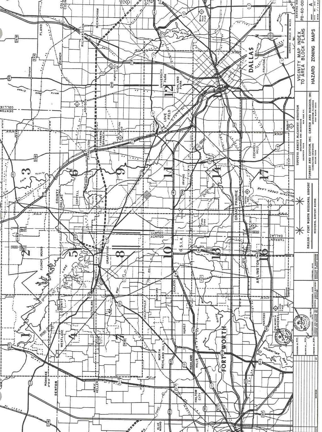
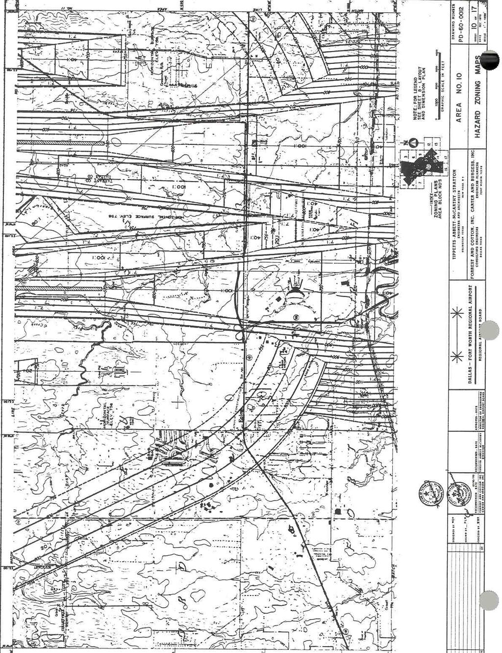
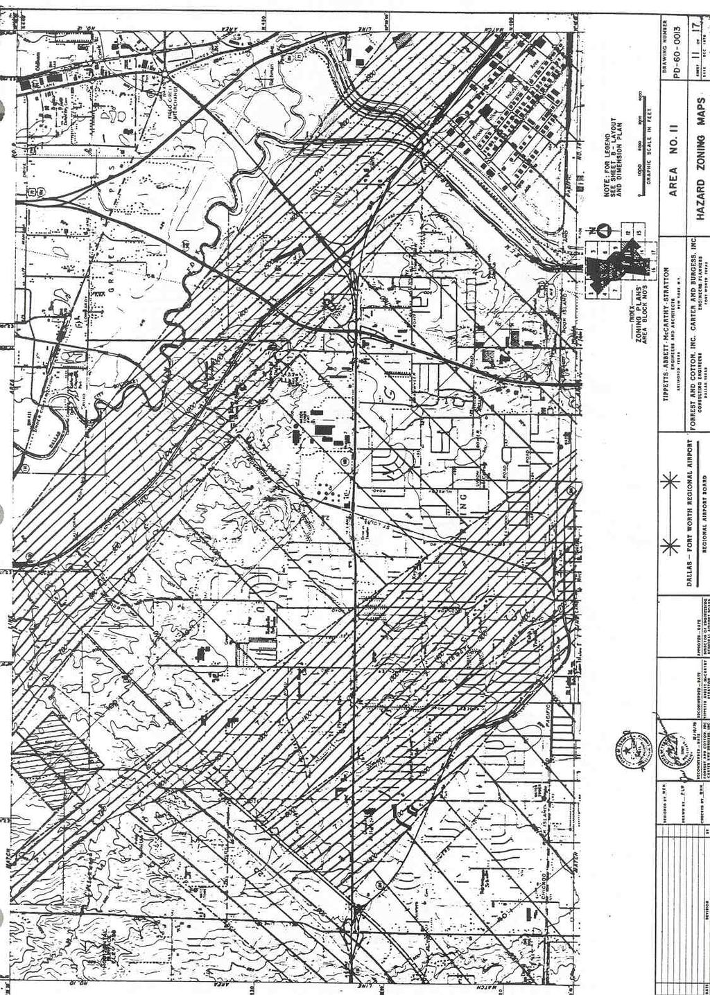
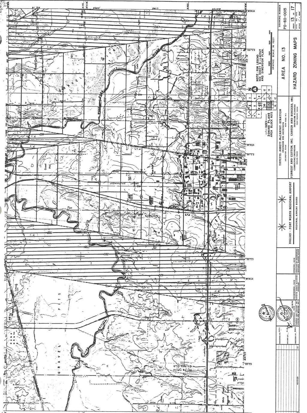
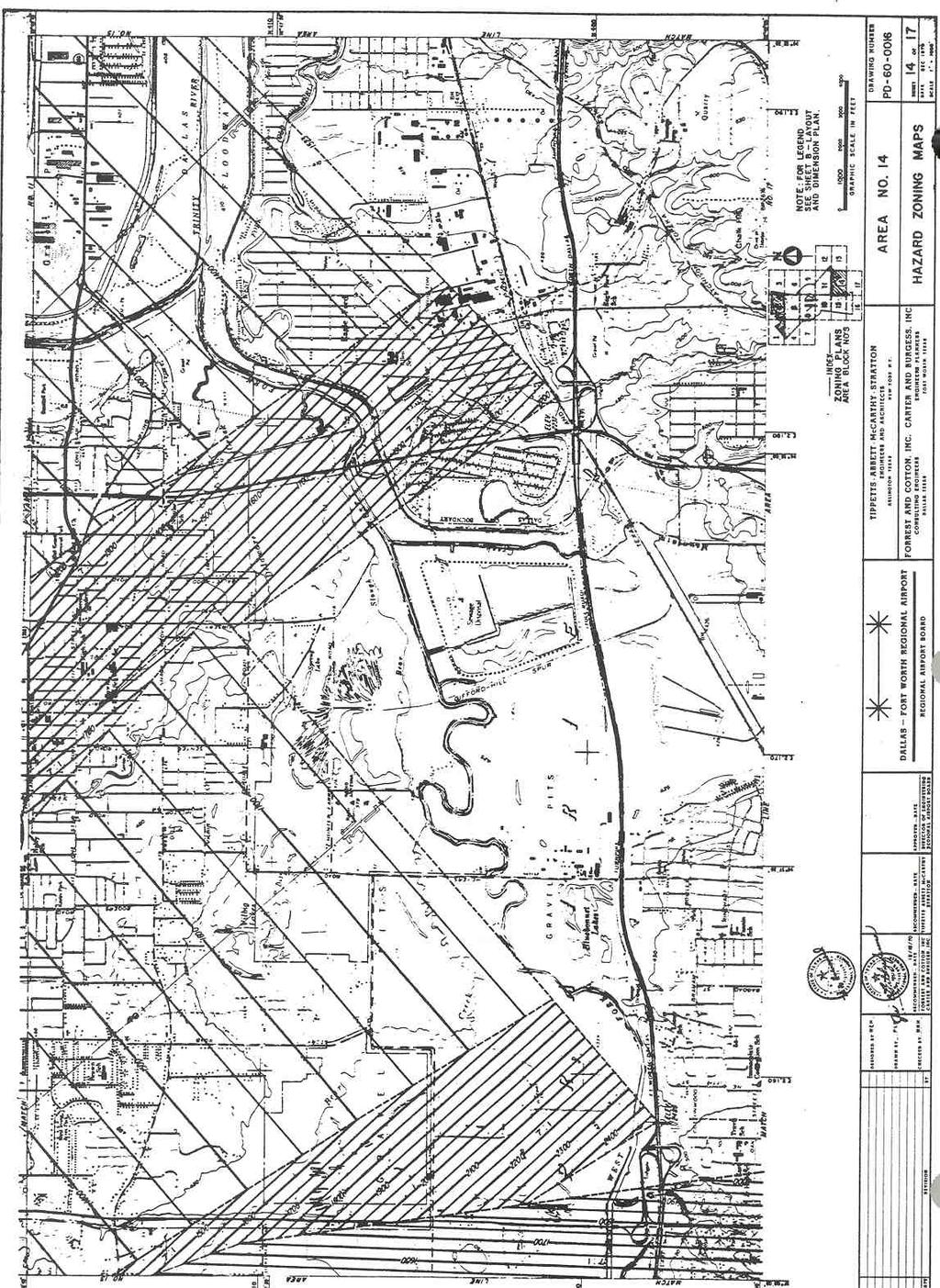
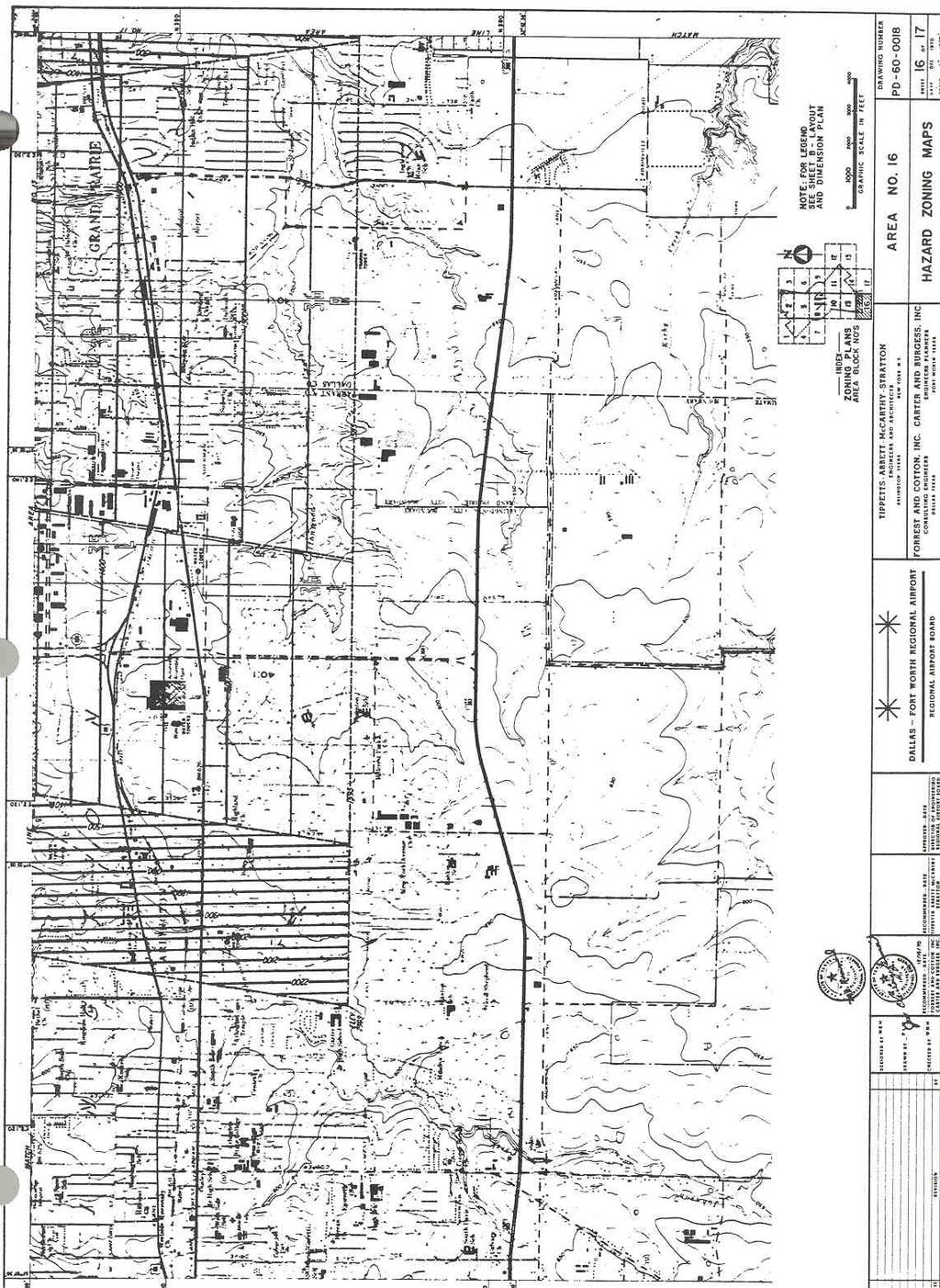
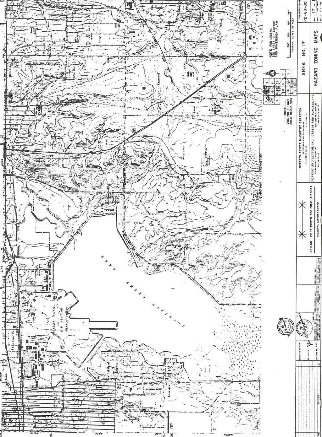
2 7.2.1 Purpose The purpose of an Airport Height/Hazard Overlay District is to prevent the establishment of hazards or obstructions to air navigation and to protect ground based property. 7.2A.1 Zones Established Dallas/Fort Worth International Airport An Airport Hazard District is hereby established for the Dallas/Fort Worth International Airport, to include all of the land lying beneath the Approach Surfaces, Transition Surfaces, Horizontal Surfaces and Conical Surfaces, as defined in this Section. Each district consists of an Approach Zone, a Transition Zone, a Horizontal Zone and a Conical Zone. The boundaries of each district and its constituent zones are shown on the Official Zoning Map for the City, and are incorporated by reference herein and made a part of these regulations. An area located in more than one of the constituent zones is considered to be only in the zone with the more restrictive height limitations. 7.2A.3 Incorporation of Hazard Maps The Hazard Zoning Maps for the Dallas/Ft. Worth Regional Airport, prepared by the engineering and architectural firm of Tippetts Abbett McCarthy Strattor, consisting of 20 pages and dated December, 1970, is hereby incorporated by reference and made a part hereof for all purposes. Reference Appendix "N". 7.2A.4 Imaginary Surfaces The following imaginary surfaces are established to implement the provisions of this ordinance. The dimensions, elevations above mean sea level, slopes and radii applicable to the imaginary surfaces shall be as shown on the Zoning Map. A. Primary Surface A surface longitudinally centered on a runway and extending beyond the ends of the runway. The elevation of any point on the primary surface is the same as the elevation of the nearest point on the runway centerline. B. Horizontal Surface A horizontal plan surface 150 feet above the established airport elevation, the perimeter of which is constructed by swinging arcs of specified radii from the center of each end of the primary surface of each runway and connecting the adjacent arcs by lines tangent to those arcs. C. Conical Surface A surface extending outward and upward from the entire perimeter, of the horizontal surface, at a specified slope and for a specified distance. B 2
3 D. Approach Surface A surface longitudinally centered on the extended runway centerline and extending outward and upward at a specified slope, and expands its horizontal dimension uniformly to a specified width. E. Transitional Surface A surface extending outward at right angles to the runway centerline and the runway centerline extended at a specified slope from the side of the primary surface and from the sides of the approach surfaces. Transitional surfaces for those portions of the conical surfaces extend a specified distance measured horizontally from the edge of the approach surface and at right angles to the runway centerline. 7.2A.5 Height Limitations Except as otherwise provided herein, no structure shall be erected, altered, or maintained, and no tree shall be allowed to grow in any Airport Hazard Zone Areas which will be above the imaginary surfaces as established by and shown on the Zoning Map. 7.2A.6 Use Restrictions Notwithstanding any other provisions of this Section, no use may be made of land or water within any airport hazard zone in such a manner as to create electrical interference with navigational signals or radio communications between the airport and aircraft, make it difficult for pilots to distinguish between airport lights and other lights, result in glare in the eyes of pilots using the airport, impair visibility in the vicinity 1 of the airport, create bird strike hazards, or otherwise in any way endanger or interfere with the landing, taking off, or maneuvering of aircraft intending to use the facilities of the airport. No other airport or landing field shall be constructed within the airport hazard area. 7.2A.7 Existing Non conformities Structures, trees or installation existing prior to the effective date of these regulations that do not conform to the requirements hereof shall be considered as legal nonconforming uses. These regulations shall not be constructed to require the removal, lowering, change or alteration of any legal non conforming use, structure, tree or installation. A permit shall be required for an illegal non conforming use and shall be issued on application of the owner or agent accompanied by affidavit that the use, structure, tree or installation was in existence on the effective date of these regulations. Applications for permits for nonconforming uses shall be made within 180 days from the effective date of these regulations. B 3
4 7.2A.8 Permits Required Before any new structure or use which could be defined as an airport hazard under this ordinance may be constructed or established and before any such existing use or structure may be increased in height or otherwise altered, a permit to do so must be secured by the owner involved or his agent. All permit applications shall be made to the Chief Building Official of the City of Grand Prairie, Texas. In any event that the Chief Building Official issues a permit erroneously allowing the beginning or erection of any structure or tree, said permit shall not constitute a variance or be construed in any manner to allow any person to penetrate the imaginary surfaces established. It will remain incumbent on the sponsor; builder, property owner or their agents, as the case may be, to prevent the creation of any object that will cause an airport hazard within the meaning of this ordinance. 7.2A.9 Notice to Federal Aviation Administration Nothing in these regulations shall be construed as relieving any owner, sponsor, or agent from the requirement for filing a notice of proposed construction or alteration with the appropriate Federal Aviation Administration Authority. 7.2A.10 Variances Any person desiring to erect any structure or increase the height of any structure, or permit the growth of any tree, or otherwise use his property in violation of these regulations may apply to the Airport Board of Adjustment for a variance from the zoning regulations in question. Such variance shall be allowed where a literal application or enforcement of the regulations would result in practical difficulty or unnecessary hardship and the relief granted would not be contrary to the public interest but do substantial justice and be in accordance with the spirit of the regulations; provided that any variance allowed shall be subject to any reasonable conditions that the Airport Board of Adjustment may deem necessary to effectuate the purposes of these regulations. 7.2A.11 Hazard Marking and Lighting Any permit granted under these regulations may, if such action is deemed advisable to effectuate the purposes of these regulations and reasonable in the circumstances, be so conditioned as to require the owner of the structure, tree or installation in question to permit the proper authority to install, operate and maintain thereon such markers and lights as the Board may find necessary to indicate the presence of the Airport Hazard. 7.2A.12 Appeals B 4 Any person aggrieved, or any taxpayer affected, by any decision of the Chief Building Official made in its administration of airport zoning regulations adopted under this Act, or any governing body of a political subdivision, or any joint airport zoning board, which
5 is of the opinion that a decision of the Chief Building Official is an improper application of airport zoning regulations of concern to such governing body or board, may appeal to the Airport Board of Adjustment authorized to hear and decide appeals. All appeals taken under this Section must be taken within a reasonable time as provided per Article 20 "General Procedures", Section 9 Airport Board of Adjustment. 7.2A.13 Judicial Review Any person aggrieved, or taxpayer affected, by any decision of the Airport Board of Adjustment, or any governing body of a political subdivision or the Joint Airport Zoning Board or Planning Department which is of the opinion that a decision of the Airport Board of Adjustment is illegal may, within ten (10) days after the decision is filed in the office of the Board, present a verified petition to a Court of Competent Jurisdiction for relief in a manner as provided in Article 46e 11(1), Texas Revised Civil Statutes. 7.2A.14 Enforcement and Remedies In addition, the City Attorney may institute in any Court of Competent Jurisdiction, an action to prevent, restrain, correct or abate any violation of these regulations or enforcement, and may be granted such relief, by way of injunction as may be proper under all the facts and circumstances of the case. 7.2A.15 Penalties Each violation of this ordinance or of any regulation, order, or ruling promulgated hereunder shall constitute a misdemeanor and be punishable by a fine of not more than $ and each day a violation continues to exist shall constitute a separate offense. 7.2A.16 Conflicting Regulations Where these regulations impose a greater or more stringent restriction upon the use of land, height of structure or trees, or the establishing or maintaining of any other airport hazard as herein defined, than is imposed by other ordinances or regulations applicable to the same area or location, the provisions of these regulations shall govern and prevail. 7.2A.17 Severability If any of the provisions of this ordinance or the application thereof to any person or circumstances is held invalid, such invalidity shall not affect other provisions or applications of this ordinance which can be given effect without the invalid provision or application, and to this end the provisions of this order are declared to be severable. B 5
6 7.2A.18 Amendments This ordinance may be amended or changed after a public hearing in relation thereto at which parties in intent and citizens shall have an opportunity to be heard. At least fifteen (15) days notice of the hearing shall be published in an official paper, or a paper of general circulation in the city in which the airport hazard area is located. 7.2A.19 Effective Date of this Ordinance October 31, 1972 The immediate operation of the provisions of this ordinance is necessary for the preservation of the public health, public safety and general welfare, an EMERGENCY is hereby declared to exist, and this ordinance shall be in full force and effect from and after is passage by the City Council and publication and posting as required by law. 7.2A.20 Administration and Enforcement The Chief Building Official shall be responsible for the administration and enforcement of these airport hazard zoning regulations. Application for a permit shall be made by filing such application with the Chief Building Official on a form published for that purpose. An application for a variance shall be made by filing such application with the Planning Director on a form published for that purpose and shall be transmitted to the Airport Board of Adjustments for determination in accordance with the procedures in Article 20 "General Procedures." 7.2A.21 Definitions The following definitions pertain only to the provisions of this Section: Airport Dallas/Fort Worth International Airport. Airport Board of Adjustments means a board of five members appointed by the Joint Airport Zoning Board as provided by Texas State law, specifically Vernon's Annotated Civil Statutes, Article 46c 10. Airport elevation means the established elevation of the highest point on the usable landing area, said elevation being 606 feet above mean sea level. Airport Hazard Any structure or tree or use of land which obstructs the air space required for the flights of aircraft or which obstructs or interferes with the control or tracking and/or data acquisition in the landing, taking off or flight at an airport, or at any installation or facility relating to flight, and tracking and/or data acquisition of the flight craft; hazardous, interfering with or obstructing such landing, taking off or flight of aircraft or which is hazardous to or interferes with tracking and/or data acquisition pertaining to flight and flight vehicles. B 6
7 Airport Hazard Area Any area of land or water upon which an airport hazard might be established if not prevented as herein provided. Airport Zone means the space between the earth's surface and the imaginary surfaces. Height for the purpose of determining the height limits in all zones set forth in this ordinance and shown on the zoning map, the datum shall mean sea level elevation unless otherwise specified. Installation means any electronic or visual interference that is not included within the definition of "structure" or "tree". Joint Airport Zoning Board means a board having as members two (2) representatives appointed by each political subdivision participating in its creation and in addition a chairman elected by a majority of the members so appointed, as established pursuant to Chapter 6 of the City Code of Ordinances and Article II of this Unified Development Code. Non conforming Use Any pre existing structure, object of natural growth, or use of land which is inconsistent with the provisions of this Section or amendment thereto. Persons means an individual, firm, partnership, corporation, company, association, joint stock association, or body politic, and includes a trustee, receiver, assignee, administrator, executor, guardian, or other representative. Chief Building Official means the person and/or department which has the responsibility for the administration and enforcement of this ordinance with regard to permits related to development and/or improvements. Political Subdivision means any municipality, city, town, village, or county. Runway A defined area on an airport prepared for landing and take off of aircraft along its length. Structure An object, including a mobile object, constructed or installed by man, including, but not limited to buildings, towers, cranes, smokestacks, earth formation, and overhead transmission lines. Tree Any object of natural growth. Zoning Map means "The Hazard Zone Maps of the Joint Airport Zoning Board for the Dallas Fort Worth Regional Airport" B 7 Utility Runway A runway that is constructed for and intended to be used by propeller driven aircraft twelve thousand five hundred (12,500) pounds maximum gross weight and less.
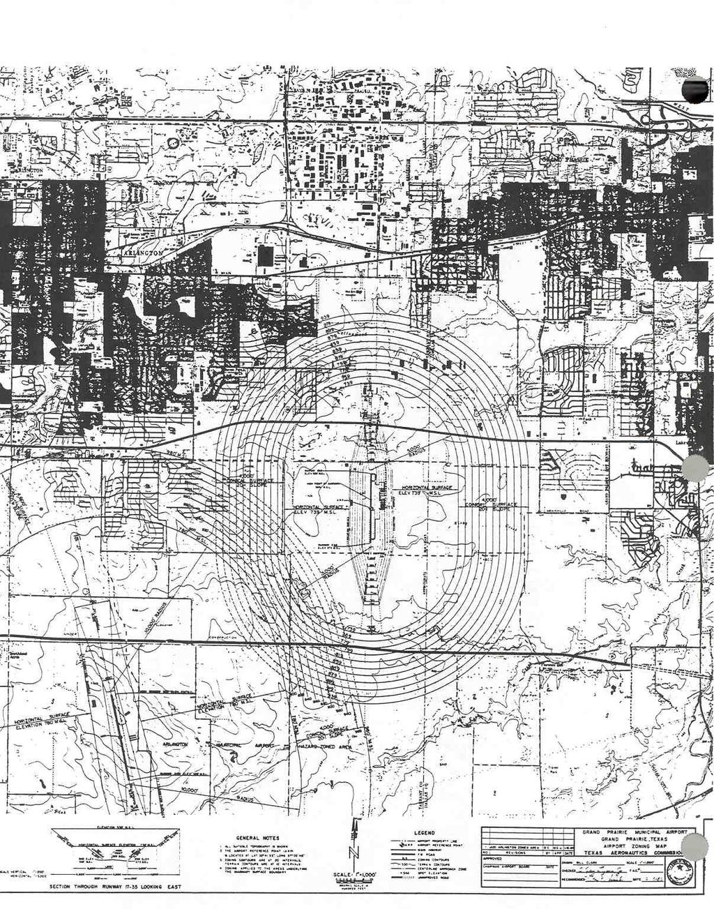
8 SECTION 2B MUNICIPAL AIRPORT ZONING ORDINANCE 7.2B.1 Zones In order to carry out the provisions of this ordinance, there are hereby created and established certain zones which include all of the land lying within the Approach Zones, Transition Zones, Horizontal Zone and Conical Zone. Such areas and zones are shown on the City of Grand Prairie Official Airport Zoning Map, consisting of one sheet, and is incorporated by reference herein and made a part of these regulations. An area located in more than one of the constituent zones is considered to be only in the zone with the more restrictive height limitations. The various zones are hereby established and defined as follows: A. Approach Zone Approach zone is established beneath the approach surface at each end of all runways on Grand Prairie Municipal Airport for north/south landings and take offs. The approach zone shall have a width of 250 feet at a distance of 200 feet beyond each end of the runway, widening thereafter uniformly to a width of 2250 feet of a horizontal distance of 10,000 feet beyond each end of the runway, its centerline being the continuation of the centerline of the runway. B. Transition Zones Transition zones are hereby established beneath the transition surface adjacent to each runway and approach surface as indicated on the zoning map. Transition surfaces, symmetrically located on either side of runways, have variable widths as shown on the zoning map. Transition surfaces extend outward from line of 125 feet on either side of the runway plus 200 feet on each end. The line is parallel to and level with the runway centerlines. The transition surfaces along such runways slope upward and outward one (1) foot vertically for each seven (7) feet horizontally to the point where they intersect the horizontal surface. Further, transition surfaces are established adjacent to approach surfaces. These transition surfaces have variable widths, as shown on the zoning map. Such transition surfaces flare symmetrically with either side of the runway approach surface from the base of such surfaces and slope upward and outward at the rate of one (1) foot vertically for each seven (7) feet horizontally to the points where they intersect the horizontal and conical surfaces. C. Horizontal Zone The area beneath a horizontal plane 150 feet above the established airport elevation, the perimeter of which is constructed by swinging arcs of 1050 feet radii from the center of each end of the primary surface of each runway and connecting the adjacent arcs by lines tangent to those arcs. D. Conical Zone The area beneath the conical surface extending outward and upward from the periphery of the horizontal surface at a slope of 20:1 for a horizontal distance of 4,000 feet. B 8
9 7.2B.2 Height Limitations Except as otherwise provided in the ordinance, no structure shall be erected, altered, allowed to grow, or maintained in any zone created by this ordinance to a height in excess of the height limit herein established for such zone. Such height limitations are herein established for such zone. Such height limitations that are hereby established for each of the zones in question are as follows: A. Approach Zones One (1) foot in height for each 20 feet in horizontal distance beginning at a point 200 feet from and at the elevation of the end of the runway and extending to a point 10,000 feet from the end of the runway. B. Transition Zones One (1) foot in height for each seven (7) feet in horizontal distance beginning at any point 125 feet normal to and at the elevation of the centerline of runway , extending 200 ft beyond each end thereof, extending to a height of 150 feet above the airport elevation or a height of feet above mean sea level. In addition to the foregoing, there are established height limits one (1) foot vertical height for each seven (7) feet horizontal distance measured from the edges of all approach zones for the entire length of the approach zones and extending upward and outward to the points where they intersect the horizontal or conical surfaces. C. Horizontal Zone That area beneath the horizontal surfaces which is located one hundred fifty (150) feet above the airport elevation, or a height of feet above mean sea level. D. Conical Zone That area beneath the conical surface which is one (1) foot in height for each twenty (20) feet of horizontal distance beginning at a periphery of the horizontal surface extending to a height of 500 feet above the airport elevation. Where an area is covered by more than one (1) height limitation, the more restrictive limitations shall prevail. 7.2B.3 Use Restrictions Notwithstanding any other provisions of this ordinance, no use may be made of land within any zone established by this ordinance in such a manner as to create electrical interference with radio communication between the airport and aircraft, make it difficult for flyers to distinguish between airport lights and others, result in glare in the eyes of flyers using the airport, impair visibility in the vicinity of the airport or otherwise endanger the landing, taking off, or maneuvering of aircraft. B 9 7.2B.4 Non Conforming Uses A. Removal of Non conforming Uses All uses, buildings, structures, or trees which
10 7.2B.5 Permits do not conform to the regulations contained in this ordinance shall be removed not later than ten (10) years from the date of this ordinance. B. Marking and Lighting During such ten (10) year period, the owner of any nonconforming structure or tree is hereby required to permit the installation, operation, and maintenance thereon of such markers and lights as shall be deemed necessary by the Grand Prairie City Council to indicate to the operators of aircraft in the vicinity of the airport, the presence of C. such airport hazards. Such markers and lights shall be installed, operated and maintained at the expense of the City of Grand Prairie. A. Future Uses Except as specifically provided in paragraphs 1, 2, and 3 hereunder, no material change shall be made in the use of land and no structure or tree shall be erected, altered, planted or otherwise established in any zone hereby created unless a permit therefore shall have been applied for and granted. Each application for a permit shall indicate the purpose for which the permit is desired, with sufficient particularity to permit it to be determined whether the resulting use, structure or tree would conform to the regulations herein prescribed. If such determination is in the affirmative, the permit shall be granted. 1 In the area lying within the limits of the Horizontal Zone and the Conical Zone, no permit shall be required for any tree or structure less than 75 feet of vertical height above the ground, except when because of terrain, land contour or topographic features, such tree or structure would extend above the height limits prescribed for such zone. 2 In the areas lying within the limits of the approach zones, but at a horizontal distance of not less than 4,200 feet from each end of the runways, no permit shall be required for any tree or structure less than 75 feet of vertical height above the ground, except when such tree or structure would extend above the height limit prescribed for such approach zone. 3 In the area lying within the limits of the transition zones beyond the perimeter of the horizontal zone, no permit shall be required for any tree or structure less than 75 feet of vertical height above the ground, except when such tree or structure, because of terrain, land contour or topographic features would extend above the height limit prescribed for such transition zone. Nothing contained in any of the foregoing exceptions shall be constructed as permitting or intending to permit any construction, alteration or growth of any structure or tree in excess of any of the height limits established by this ordinance except as set forth B 10
11 7.2B.4 "Use Restrictions". in Subsection Nothing contained in any of the foregoing shall be construed as permitting a violation of any other codes or ordinances of the City of Grand Prairie, Texas. B. Existing Uses No permit shall be granted that would allow the establishment or creation of an airport hazard or permit a non conforming use, structure, or tree to be made or become higher, or become a greater hazard to air navigation, than it was on the effective date of this ordinance or any amendments thereto or than it is when the application for a permit is made. Except as indicated, all applications for such a permit shall be granted. C. Non conforming Uses Abandoned or Destroyed Whenever the City Council determines that a non conforming structure or tree has been abandoned or more than 80 percent torn down, physically deteriorated, or decayed, no permit shall be granted that would allow such structure or tree to exceed the applicable height limit or otherwise deviated from the zoning regulations. D. Variances Any person desiring to erect or increase the height of any structure, or permit the growth of any tree, or use his property, not in accordance with the regulations prescribed in this ordinance, may apply to the Board of Adjustment for a variance from such regulations. Such variances shall be allowed where it is duly found that a literal application or enforcement of the regulations would result in unnecessary hardship and the relief granted would not be contrary to the public interest but will do substantial justice and be in accordance with the spirit of this ordinance. E. Hazard Marking and Lighting Any permit or variance granted may, if such action is deemed advisable to effectuate the purpose of this ordinance and be reasonable in the circumstances, be so conditioned as to require the owner of the structure or tree in question to permit the City of Grand Prairie at the owners expense to install, operate, and maintain thereon such markers and lights as may be necessary to indicate to flyers the presence of a hazard. 7.2B.6 Enforcement It shall be the duty of the Chief Building Official to administer and enforce the regulations prescribed herein. Application for permits shall be made to the Chief Building Official upon a form furnished by such department. Applications required by this ordinance to be submitted to the Chief Building Official shall be promptly considered and granted or denied by him. 7.2B.7 Appeals B 11 Any person aggrieved, or any taxpayer affected, by any decision of the Chief Building Official made in his administration of this ordinance, if of the opinion that a decision of
12 the Chief Building Official is an improper application of these regulations, may appeal to the Zoning Board of Adjustment. All appeals hereunder must be taken within a reasonable time as provided in Article XX "General Procedures", Section 7 Zoning Board of Adjustments and Appeals. 7.2B.8 Penalties Each violation of this ordinance or of any regulation, order, or ruling promulgated hereunder shall constitute a misdemeanor and be punishable by a fine of not more than $ and each day a violation continues to exist shall constitute a separate offense. 7.2B.9 Conflicting Regulations Where there exists a conflict between any of the regulations applicable to the same area, whether the conflict be with respect to the height of structures or trees, the use of land, or any other matter, the more stringent limitation or requirement shall govern and prevail. 7.2B.10 Severability If any of the provisions of this ordinance or the application thereof to any person or circumstances is held invalid, such invalidity shall not affect other provisions or applications of this ordinance which can be given effect without the invalid provision or application, and to this end the provisions of this order are declared to be severable. 7.2B.12 Effective Date of Ordinance March 22, 1977 Whereas, the immediate operation of the provisions of this ordinance is necessary for the preservation of the public health, public safety and general welfare, and emergency, is hereby declared to exist, and this ordinance shall be in full force and effect from and after its passage by the City Council and publication and posting as required by law. 7.2B.13 Definitions Airport means Grand Prairie Municipal Airport. Airport Elevation means the established elevation of the highest point on the usable landing area. Airport Hazard means any structure, tree or use of land which obstructs the airspace required for or is otherwise hazardous to the flight of aircraft in landing or taking off at the airport. B 12 Airport Reference Point means the point established as the approximate geographic center of the airport landing area and so designated.
13 Board of Adjustments means the Zoning Board of Adjustments and Appeals of the City of Grand Prairie, Texas. Height for the purpose of determining the height limits in all zones set forth in this ordinance and shown on the zoning map, the datum shall mean sea level elevation unless otherwise specified. Landing Area means the surface area of the Airport used for the landing, taking off or taxiing of aircrafts. Non conforming Use means any structure, tree, or use of land which is lawfully in existence at the time the regulation is prescribed in the ordinance or an amendment thereto becomes effective and does not then meet the requirements of said regulations. Person means an individual, firm, partnership, corporation, company, association, point stock association. Runway means the paved or unpaved surface of an airport landing strip. Structure means an object constructed or installed by man, including, but without limitation, buildings, towers, smokestacks, and overhead transmission lines. B 13
14 B 14
15 B 15
16 B 16
17 B 17
18 B 18
19 B 19
20 B 20
21 B 21
22 B 22
23 B 23
24 B 24
AIRPORT HAZARD ZONING ORDINANCE BRAZORIA COUNTY AIRPORT
 AIRPORT HAZARD ZONING ORDINANCE BRAZORIA COUNTY AIRPORT AN ORDINANCE REGULATING AND RESTRICTING THE HEIGHT OF STRUCTURES AND OBJECTS OF NATURAL GROWTH, AND OTHERWISE REGULATING THE USE OF PROPERTY, IN
BRECKNOCK TOWNSHIP, BERKS COUNTY, PENNSYLVANIA ORDINANCE NO. 167
 BRECKNOCK TOWNSHIP, BERKS COUNTY, PENNSYLVANIA ORDINANCE NO. 167 AN ORDINANCE OF THE BOARD OF SUPERVISORS OF BRECKNOCK TOWNSHIP AMENDING THE BRECKNOCK TOWNSHIP ZONING ORDINANCE TO ADD A NEW SECTION 27-210
CHAPTER 7 AIRPORT HEIGHT ZONING OF SCOTT COUNTY/DAVENPORT AIRPORT
 SECTIONS: 7-1. TITLE 7-2. CONFLICTING REGULATIONS 7-3. DEFINITIONS 7-4. ZONES AND HEIGHT LIMITATIONS 7-5. NONCONFORMING USES 7-6. APPLICATIONS AND PERMITS 7-7. ENFORCEMENT 7-8. VARIANCES 7-9. DAVENPORT
ORDINANCE TO LIMIT HEIGHT OF OBJECTS AND TO REGULATE PLACEMENT OF CERTAIN STRUCTURES WITHIN SPECIFIC AREAS OF NOISE LEVEL
 ORDINANCE TO LIMIT HEIGHT OF OBJECTS AND TO REGULATE PLACEMENT OF CERTAIN STRUCTURES WITHIN SPECIFIC AREAS OF NOISE LEVEL AROUND EASTERN WEST VIRGINIA REGIONAL AIRPORT REENACTMENT AND AMENDMENT OF BERKELEY
City of Winsted, Minnesota. Airport Zoning Ordinance. Winsted Municipal Airport
 CHAPTER 18 City of Winsted, Minnesota Airport Zoning Ordinance Winsted Municipal Airport September 25, 2002 18-1 Table of Contents Introduction... 18-4 Section I: Purpose and Authority... 18-5 Section
City of Winsted, Minnesota. Airport Zoning Ordinance. Winsted Municipal Airport
 CHAPTER 18 City of Winsted, Minnesota Airport Zoning Ordinance Winsted Municipal Airport September 25, 2002 18-1 Table of Contents Introduction... 18-4 Section I: Purpose and Authority... 18-5 Section
Airport Safety Zoning Ordinance for
 Airport Safety Zoning Ordinance for the Le Sueur Municipal Airport (12Y) Adopted March 18, 2014 Approved by the Joint Airport Zoning Board This ordinance amends and replaces adopted January 1979. Table
Table of Contents. Aitkin Airport Zoning Ordinance 1 of 20
 Table of Contents TITLE AND INTRODUCTION... 2 SECTION 1: PURPOSE AND AUTHORITY... 3 SECTION 2: SHORT TITLE... 4 SECTION 3: DEFINITIONS... 5 SECTION 4: AIR SPACE OBSTRUCTION ZONING... 7 SECTION 5: LAND
Instructions to assist you in completing the Minnesota Model Airport Safety Zoning Ordinance.
 Instructions to assist you in completing the Minnesota Model Airport Safety Zoning Ordinance. We encourage you to call our staff before you begin the zoning process. It puts us on notice of your zoning
CHAPTER 21 AIRPORT REGULATING HEIGHT OF STRUCTURES TREES AND PROPERTY
 CHAPTER 21 AIRPORT REGULATING HEIGHT OF STRUCTURES TREES AND PROPERTY 21.01 Definitions 21.02 Area of Jurisdiction 21.03 Activities Regulated 21.04 Nonconforming Use 21.05 Administration 21.06 Permits
(4) Airport hazard area means any area of land or water upon which an airport hazard might be established.
 Airport hazard area means any area of land or water upon which an airport hazard might be established.") New FS 333 CHAPTER 333 AIRPORT ZONING 333.01 Definitions. 333.02 Airport hazards and uses of land in airport vicinities contrary to public interest. 333.025 Permit required for obstructions. 333.03 Requirement
New FS 333 CHAPTER 333 AIRPORT ZONING 333.01 Definitions. 333.02 Airport hazards and uses of land in airport vicinities contrary to public interest. 333.025 Permit required for obstructions. 333.03 Requirement
City of Montevideo, Minnesota. Airport Zoning Ordinance. Montevideo-Chippewa County Airport. Adopted March 13, 1984 and Revised October 10, 2006
 City of Montevideo, Minnesota Airport Zoning Ordinance Montevideo-Chippewa County Airport Adopted March 13, 1984 and Revised October 10, 2006 Table of Contents Introduction...1 Section I: Purpose And Authority...2
The 2006 Florida Statutes
 Page 1 of 15 Select Year: 2006 Go The 2006 Florida Statutes CHAPTER 333 AIRPORT ZONING 333.01 Definitions. 333.02 Airport hazards and uses of land in airport vicinities contrary to public interest. 333.025
ZONING ORDINANCE FOR THE TRI-COUNTY REGIONAL AIRPORT
 ZONING ORDINANCE FOR THE TRI-COUNTY REGIONAL AIRPORT Section 1 Statutory Authorization and Purpose.... 1 Section 2 Definitions.... 1 Section 3 General Provisions.... 2 Section 4 Airport Zones.... 3 Section
ORDINANCE NO. _--,9,--_ THE COUNTY BOARDS OF THE COUNTIES OF IOWA, RICHLAND AND SAUK, WISCONSIN, DO ORDAIN AS FOLLOWS:
 ORDINANCE NO. _--,9,--_ REGULATING THE HEIGHT OF STRUCTURES AND TREES IN THE VICINITY OF THE TRI COUNTY REGIONAL AIRPORT, LONE ROCK, SAUK COUNTY, WISCONSIN. THE COUNTY BOARDS OF THE COUNTIES OF IOWA, RICHLAND
BRAZORIA COUNTY ANGLETON - LAKE JACKSON JOINT AIRPORT ZONING BOARD COMPATIBLE LAND USE ZONING ORDINANCE NO. II
 BRAZORIA COUNTY ANGLETON - LAKE JACKSON JOINT AIRPORT ZONING BOARD COMPATIBLE LAND USE ZONING ORDINANCE NO. II AN ORDINANCE REGULATING AND RESTRICTING THE USE OF PROPERTY IN THE VICINITY OF THE BRAZORIA
TUSCOLA AREA AIRPORT ZONING ORDINANCE
 TUSCOLA AREA AIRPORT ZONING ORDINANCE ADOPTED BY THE TUSCOLA COUNTY BOARD OF COMMISSIONERS UNDER THE AUTHORITY OF IN COMPLIANCE WITH PA110 OF 2006 COUNTY ORDINANCE # 01-2010 ORDINANCE ADMINISTRATED BY:
Greg Jones Airspace and Land Use Manager (850)
") Florida Chapter 333, Airport Zoning Greg Jones Airspace and Land Use Manager (850) 414-4502 Aviation and Spaceports Office 605 Suwannee Street, MS 46 Tallahassee, FL 32399-0450 Greg.Jones@dot.state.fl.us
Florida Chapter 333, Airport Zoning Greg Jones Airspace and Land Use Manager (850) 414-4502 Aviation and Spaceports Office 605 Suwannee Street, MS 46 Tallahassee, FL 32399-0450 Greg.Jones@dot.state.fl.us
DUPLIN COUNTY AIRPORT AIRPORT LAND USE AND HEIGHT RESTRICTION ORDINANCE
 DUPLIN COUNTY AIRPORT AIRPORT LAND USE AND HEIGHT RESTRICTION ORDINANCE PREPARED BY: THE DUPLIN COUNTY PLANNING BOARD AND THE DUPLIN COUNTY AIRPORT COMMISSION EFFECTIVE: MAY 1, 2009 ENACTMENT PREAMBLE
NC General Statutes - Chapter 63 1
 Chapter 63. Aeronautics. Article 1. Municipal Airports. 63-1. Definitions; singular and plural. (a) Definitions. For the purpose of this Chapter the following words, terms, and phrases shall have the meanings
MUNICIPALITY OF MONROEVILLE ALLEGHENY COUNTY, PENNSYLVANIA ORDINANCE NO. 2553
 MUNICIPALITY OF MONROEVILLE ALLEGHENY COUNTY, PENNSYLVANIA ORDINANCE NO. 2553 AN ORDINANCE OF THE COUNCIL OF THE MUNICIPALITY OF MONROEVILLE, ALLEGHENY COUNTY, PENNSYLVANIA, AMENDING ORDINANCE NO. 1443,
ORDINANCE FOR PRIVATE USE HELICOPTERS SECTION 1
 ORDINANCE FOR PRIVATE USE HELICOPTERS SECTION 1 SHORT TITLE: This Ordinance shall be known and may be cited as Ordinance for Heliports. SUMMARY: Helicopter landings, take-offs, and hovering are prohibited
A. Preserve and enhance Pottstown s traditional town character, protect its historic resources, and revitalize its older areas.
 APPENDIX A1 Purpose SECTION A100 General Purpose The intent of this Article is to establish a precise and detailed plan for the use of land in the Borough, and it is enacted to promote and to protect the
PURPOSE & APPLICABILITY
 1.1 TITLE This ordinance is officially titled The Planning Ordinance of the Town of Davidson, North Carolina and shall be known as the Planning Ordinance. The official map designating the various planning
Fence By-law. PS-6 Consolidated May 14, As Amended by: PS March 20, 2012 PS May 14, 2013
 Fence By-law PS-6 Consolidated May 14, 2013 As Amended by: By-law No. Date Passed at Council PS-6-12001 March 20, 2012 PS-6-13002 May 14, 2013 This by-law is printed under and by authority of the Council
ARTICLE IV ADMINISTRATION
 Highlighted items in bold and underline font are proposed to be added. Highlighted items in strikethrough font are proposed to be removed. CHAPTER 4.01. GENERAL. Section 4.01.01. Permits Required. ARTICLE
PROPERTY MAINTENANCE. Chapter 438 FENCES - HEIGHT - REGULATION
 PROPERTY MAINTENANCE Chapter 438 FENCES - HEIGHT - REGULATION 4381.1 Boulevard - defined 438.1.2 Engineer - defined CHAPTER INDEX Article 1 INTERPRETATION 438.1.3 Exterior side yard - defined 438.1.4 Fence
Section 3. Compliance with County and Appalachian Board of Health Rules.
 STATE OF NORTH CAROLINA COUNTY OF WATAUGA WATAUGA COUNTY MANUFACTURED HOME PARKS ORDINANCE Section 1. Authority and Purpose. Pursuant to the authority granted to counties in North Carolina General Statute
AN ORDINANCE REGULATING THE SETBACK DISTANCE OF STRUCTURES FROM THE RIGHT-OF-WAY OF HIGHWAYS
 ORDINANCE NUMBER 39 AN ORDINANCE REGULATING THE SETBACK DISTANCE OF STRUCTURES FROM THE RIGHT-OF-WAY OF HIGHWAYS WHEREAS, the Board of Commissioners of Wabasha County, Minnesota, deems it in the best interest
TITLE 18 - Signs and Related Regulations
 TITLE 18 - Signs and Related Regulations CHAPTER 18.01 GENERAL PROVISIONS 18.01.010 Title 18.01.020 Purpose 18.01.030 Compliance with Title Provisions 18.01.040 Interpretation 18.01.050 Relationship to
THE COUNTY BOARD OF SUPERVISORS OF THE COUNTY OF DOUGLAS DOES ORDAIN AS FOLLOWS:
 4.28 PRIMARY STRUCTURE ADDRESS ORDINANCE THE COUNTY BOARD OF SUPERVISORS OF THE COUNTY OF DOUGLAS DOES ORDAIN AS FOLLOWS: SECTION I. PURPOSE This ordinance provides a system by which all primary structures
SHOHOLA TOWNSHIP ORDINANCE # 53 REGULATING E-911 STREET & HOUSE NUMBER SIGNS
 SHOHOLA TOWNSHIP ORDINANCE # 53 REGULATING E-911 STREET & HOUSE NUMBER SIGNS AN ORDINANCE OF THE TOWNSHIP OF SHOHOLA, PIKE COUNTY, PENNSYLVANIA, ESTABLISHING A COORDINATED AND UNIFORM SYSTEM FOR 911 (EMERGENCY)
Iowa County Airport Zoning Ordinance
 Ordinance No. 400.16 Iowa County Airport Zoning Ordinance Iowa County, Wisconsin Copies are available at the Office of Planning & Development 222 N. Iowa Street Dodgeville, WI 53533 (608) 935-0398 www.iowacounty.org
ORDINANCE NO WHEREAS, by act of the General Assembly of Virginia as codified by Chapter 11,
 ORDINANCE NO. 640 AN ORDINANCE REGULATING AND RESTRICTING THE USE OF LAND AND THE USE AND LOCATION OF BUILDINGS AND STRUCTURES; REGULATING AND RESTRICTING THE HEIGHT AND BULK OF BUILDINGS AND STRUCTURES
CITY ORDINANCE NO. 585
 CITY ORDINANCE NO. 585 AN ORDINANCE OF THE CITY OF ABERNATHY AMENDING ORDINANCE 310 (ZONING CODE) OF THE CITY OF ABERNATHY AND REPEALING ALL LAWS OR ORDINANCES OR PARTS OF ORDINANCES IN CONFLICT THEREWITH;
Borough of Berwick ORDINANCE
 Borough of Berwick ORDINANCE 2016-02 AN ORDINANCE BY THE BOROUGH OF BERWICK IN COLUMBIA COUNTY, PENNSYLVANIA. SETTING RULES & REGULATIONS FOR THE POSTING OF SIGNS IN THE BOROUGH OF BERWICK BE IT ORDAINED
ARTICLE I GENERAL PROVISIONS
 CHAPTER 1.01. TITLE AND APPLICATION. Section 1.01.01. Title. ARTICLE I GENERAL PROVISIONS This ordinance shall be known, cited and referred to as the Joint Zoning Ordinance for Brookings County and the
City CQ)f WesiwCQ)Jrth Village 31]1 Bm ' ~o:n JHljl1 IRo 'Il '~ VVest-wodh Village, T :g: ]Pax ll7.7jlo.2501
![City CQ)f WesiwCQ)Jrth Village 31]1 Bm ' ~o:n JHljl1 IRo 'Il '~ VVest-wodh Village, T :g: ]Pax ll7.7jlo.2501](/thumbs/94/122322509.jpg "City CQ)f WesiwCQ)Jrth Village 31]1 Bm ' ~o:n JHljl1 IRo 'Il '~ VVest-wodh Village, T :g: ]Pax ll7.7jlo.2501") City CQ)f WesiwCQ)Jrth Village 31]1 Bm ' ~o:n JHljl1 IRo 'Il '~ VVest-wodh Village, T :g: 76114 817.710.2500 ]Pax ll7.7jlo.2501 ORDINANCE NO. 423 AN ORDINANCE OF THE CITY OF WESTWORTH VILLAGE AMENDING
City CQ)f WesiwCQ)Jrth Village 31]1 Bm ' ~o:n JHljl1 IRo 'Il '~ VVest-wodh Village, T :g: 76114 817.710.2500 ]Pax ll7.7jlo.2501 ORDINANCE NO. 423 AN ORDINANCE OF THE CITY OF WESTWORTH VILLAGE AMENDING
ARTICLE 15 ADMINISTRATIVE PROCEDURE AND ENFORCEMENT
 ARTICLE 15 ADMINISTRATIVE PROCEDURE AND ENFORCEMENT Section 1501 Brule County Zoning Administrator An administrative official who shall be known as the Zoning Administrator and who shall be designated
FRANKLIN TOWNSHIP YORK COUNTY, PENNSYLVANIA ORDINANCE NO
 FRANKLIN TOWNSHIP YORK COUNTY, PENNSYLVANIA ORDINANCE NO. 2018-3 AN ORDINANCE AMENDING THE FRANKLIN TOWNSHIP ZONING ORDINANCE (ORDINANCE NO. 2006-1, AS AMENDED) TO REPLACE SECTION 205, PERTAINING TO STEEP
COMMUNICATION TOWERS
 COMMUNICATION TOWERS INDEX SECTION PAGE Article I Definitions 1 Article II Application for Construction of a Communication Tower 1 Article III Approval Criteria 3 Article IV Co-location on Existing Structures
THE CORPORATION OF THE DISTRICT OF SAANICH BYLAW NO. 5576
 THE CORPORATION OF THE DISTRICT OF SAANICH BYLAW NO. 5576 TO REGULATE OR PROHIBIT THE REMOVAL OF SOIL, SAND, GRAVEL ROCK OR OTHER SUBSTANCE OF WHICH LAND IS COMPOSED FROM LANDS WITHIN THE CORPORATION OF
Rules of Procedure. Hamilton, Ohio. Board of Zoning Appeals. January, Introduction
 Rules of Procedure Hamilton, Ohio Board of Zoning Appeals January, 2018 Introduction Section 1160.20 of the Zoning Code of the City of Hamilton provides that the board shall adopt its own rules of procedure.
CITY OF SNOHOMISH Snohomish, Washington ORDINANCE 2325
 CITY OF SNOHOMISH Snohomish, Washington ORDINANCE 2325 AN ORDINANCE OF THE CITY OF SNOHOMISH, WASHINGTON, AMENDING THE CITY S DEVELOPMENT CODE BY AMENDING SMC SECTION 14.100.020 - DEFINITIONS; REPEALING
TITLE III BUILDING AND FIRE REGULATIONS CHAPTER 1 BUILDING CODE
 CHAPTER 1 BUILDING CODE Section 3.1.1 Adoption of Building Code There is hereby adopted by the City of Mount Vernon, South Dakota, for the purpose of establishing rules and regulations for the construction,
Suburban; Rural Town of Brookhaven Tree Preservation Ordinance. Abstract. Resource. Topic:
 Land Use Law Center Gaining Ground Information Database Topic: Resource Type: State: Jurisdiction Type: Municipality: Year (adopted, written, etc.): 1989-1992 Community Type applicable to: Title: Document
SIGN ORDINANCE NOTICE
 SIGN ORDINANCE NOTICE On October 18,1973 the Selectmen of the Town of Arlington adopted the Arlington Sign Ordinance, which Ordinance is hereafter set forth in full. TAKE NOTICE that this Ordinance shall
NC General Statutes - Chapter 136 Article 12 1
 Article 12. Junkyard Control Act. 136-141. Title of Article. This Article may be cited as the Junkyard Control Act. (1967, c. 1198, s. 1.) 136-142. Declaration of policy. The General Assembly hereby finds
ORDINANCE NO BE IT FURTHER ENACTED AND ORDAINED by the Mayor and City Council of Laurel, Maryland that
 ORDINANCE NO. 1932 AN ORDINANCE OF THE MAYOR AND CITY COUNCIL OF LAUREL, MD TO AMEND THE CITY OF LAUREL UNIFIED LAND DEVELOPMENT CODE; CHAPTER 20, LAND DEVELOPMENT AND SUBDIVISION, TO ADD ARTICLE VIA,
Montcalm County Address Ordinance
 Montcalm County Address Ordinance (Revisions dated 4/27/01) (Amended 03/08/04) (Amended 06/26/06) (Amended 09/24/12) (Amended 10/15/14) (Amended 07/25/16) (Amended 03/26/18) ARTICLE I TITLE, PURPOSE, AND
THE CORPORATION OF THE CITY OF WATERLOO
 THE CORPORATION OF THE CITY OF WATERLOO BY-LAW NUMBER 2013-0 1] A BY-LAW TO PROVIDE FOR THE REGULATION OF FENCES AND PRIVACY SCREENS WITHIN THE CITY OF WATERLOO WHEREAS section 11 (3)(7) of the Municipal
TITLE 16 STREETS AND SIDEWALKS, ETC 1 CHAPTER 1 MISCELLANEOUS
 16-1 TITLE 16 STREETS AND SIDEWALKS, ETC 1 CHAPTER 1. MISCELLANEOUS. 2. SIGNS IN RIGHTS-OF-WAY. 3. LINES OF SIGHT AT INTERSECTIONS. CHAPTER 1 MISCELLANEOUS SECTION 16-101. Definitions. 16-102. Permit to
STATE OF MICHIGAN COUNTY OF WAYNE CITY OF ALLEN PARK
 STATE OF MICHIGAN COUNTY OF WAYNE CITY OF ALLEN PARK ORDINANCE 04-2015 AN ORDINANCE OF THE CITY OF ALLEN PARK CODE OF ORDINANCES; AMENDING CHAPTER 52, ZONING, ARTICLE VI, SUPPLEMENTAL REGULATIONS, BY THE
CITY OF WEST LAKE HILLS. AMENDMENT No. 252 BUILDING HEIGHT
 CITY OF WEST LAKE HILLS AMENDMENT No. 252 BUILDING HEIGHT AN ORDINANCE AMENDING TITLE II, CHAPTER 22 OF THE WEST LAKE HILLS CODE OF ORDINANCES; MODIFYING METHODS FOR DETERMINING BUILDING HEIGHT, ESTABLISHING
ARTICLE CURB CUTS*
 ARTICLE 4.1100 CURB CUTS* Sec. 4.1101 Definitions For the purpose of construction and enforcement of this article, certain abbreviations, terms, phrases and their derivatives shall be construed as set
REPORT AND RECOMMENDATIONS RELATING TO AVIATION
 REPORT AND RECOMMENDATIONS RELATING TO AVIATION NEW JERSEY LAW REVISION COMMISSION 15 Washington Street Newark, New Jersey 07102 (201)648-4575 June, 1992 C:\rpts\aviat.doc CHAPTERS 41, 42 AND 43 AERONAUTICS,
BOARD OF ZONING APPEALS
 ARTICLE 24 BOARD OF ZONING APPEALS 2400 APPOINTMENT, SERVICE The Board of Zoning Appeals (BZA) shall consider a Variance, Exception, Conditional Use, or an Appeal request. The BZA shall consist of five
ORDINANCE NO * * * * * WHEREAS, the City Council of the City of Mont Belvieu, Texas, ( City ) is
 is") ORDINANCE NO. 2013- AN ORDINANCE AMENDING THE ZONING ORDINANCE OF THE CITY OF MONT BELVIEU, TEXAS, TO PROVIDE FOR CHANGES IN THE ZONING CODE RELATED TO LANDSCAPING; PROVIDING FOR SEVERABILITY; PROVIDING
ORDINANCE NO. 2013- AN ORDINANCE AMENDING THE ZONING ORDINANCE OF THE CITY OF MONT BELVIEU, TEXAS, TO PROVIDE FOR CHANGES IN THE ZONING CODE RELATED TO LANDSCAPING; PROVIDING FOR SEVERABILITY; PROVIDING
WASHINGTON COUNTY HIGHWAY DEPARTMENT Policy & Procedure Number Adopted on January 1, 1999 Revised on December 2, 2014
 WASHINGTON COUNTY HIGHWAY DEPARTMENT Policy & Procedure Number 12.05 Adopted on January 1, 1999 Revised on December 2, 2014 (1) This policy and procedure is adopted to promulgate rules to regulate and
APPLICATION FOR PIPELINE PUBLIC ROAD CROSSING PERMIT
 THE STATE OF TEXAS COUNTY OF BURLESON APPLICATION FOR PIPELINE PUBLIC ROAD CROSSING PERMIT TO: THE COMMISSIONERS COURT OF BURLESON COUNTY, TEXAS GENTLEMEN: ON THIS THE day of, 20, the undersigned, hereinafter,
Chapter SIGN REGULATIONS Statement of purpose Definitions. Page 1. Sections:
 Chapter 10.38 - SIGN REGULATIONS Sections: 10.38.020 - Statement of purpose. (a) The purpose of this chapter is to accommodate and promote sign placement consistent with the character and intent of the
ARTICLE 2. ADMINISTRATION CHAPTER 20 AUTHORITY OF REVIEWING/DECISION MAKING BODIES AND OFFICIALS Sections: 20.1 Board of County Commissioners.
 Article. ADMINISTRATION 0 0 ARTICLE. ADMINISTRATION CHAPTER 0 AUTHORITY OF REVIEWING/DECISION MAKING BODIES AND OFFICIALS Sections: 0. Board of County Commissioners. 0. Planning Commission. 0. Board of
Outer Continental Shelf Lands Act of 7 August 1953
 Page 1 Outer Continental Shelf Lands Act of 7 August 1953 Paragraph 1331. Definitions When used in this subchapter - The term "outer Continental Shelf" means all submerged lands lying seaward and outside
CHAPTER 13 HISTORIC PRESERVATION COMMISSION
 CHAPTER 13 HISTORIC PRESERVATION COMMISSION SECTION: 2-13- 1: Purpose Of Provisions 2-13- 2: Commission On Glen Ellyn Landmarks 2-13- 3: Designation Of Landmark Or Landmark District; Recommendation And
ARTICLE 1. GENERAL PROVISIONS
 ARTICLE 1. GENERAL PROVISIONS Table of Contents Section 1.010. Short title; introduction to Chapter... 2 Section 1.020. Authority... 2 Section 1.030. Jurisdiction... 2 Section 1.040. Purpose (Amend. #33)...
TOWN OF BELMONT NEW HAMPSHIRE DRIVEWAY REGULATIONS. Wording to be eliminated is crossed out Wording to be added is bold, italicized
 TOWN OF BELMONT NEW HAMPSHIRE DRIVEWAY REGULATIONS Wording to be eliminated is crossed out Wording to be added is bold, italicized ENACTED: MARCH 9, 1992 EDITION: TBD (Draft Date 6/7/18) TABLE OF CONTENTS
SESSION OF 1984 Act No AN ACT
 SESSION OF 1984 Act 1984-164 837 SB 785 No. 1984-164 AN ACT Amending Title 74 (Transportation) of the Pennsylvania Consolidated Statutes, adding revised, codified and compiled provisions relating to aviation;
BLDG. CONSTR. & FIRE PREV. LOCAL LAW BUILDING CONSTRUCTION AND FIRE PREVENTION
 BLDG. CONSTR. & FIRE PREV. LOCAL LAW 3-1992 BUILDING CONSTRUCTION AND FIRE PREVENTION ARTICLE I ADMINISTRATION AND E NFO RCEMENT OF UNIFORM CODE Sec. 100.0 Designation of Building Inspector Sec 100.1 Acting
Littering Statutes for Political Candidates in North Carolina
 2016 SIGN ORDINANCE INFORMATION Littering Statutes for Political Candidates in North Carolina 14-156. Injuring fixtures and other property of electric-power companies. It shall be unlawful for any person
BOARD OF ADJUSTMENT APPLICATION
 BOARD OF ADJUSTMENT APPLICATION Meeting Date: Application Deadline: Application Fee: See attached schedule for dates. Meeting begins promptly at 5:30 p.m. in the 2 nd Floor Conference Room, City Hall,
CITY OF RUSTON. Inspection Department Fax: OFF-PREMISE SIGN PERMIT APPLICATION SITE PLAN MUST BE INCLUDED WITH APPLICATION
 Permit # CITY OF RUSTON Inspection Department 318-251-8640 Fax: 318-251-8650 OFF-PREMISE SIGN PERMIT APPLICATION SITE PLAN MUST BE INCLUDED WITH APPLICATION APPLICANT/PERSON ENTITLED TO POSSESSION OF SIGN:
A. The Board of Adjustment members and appointment procedure.
 ARTICLE 27, BOARD OF ADJUSTMENT Section 1, Members and General Provisions. A. The Board of Adjustment members and appointment procedure. 1. The Board of Adjustment shall consist of five residents of the
EXCERPTS FROM ROSEMEAD MUNICIPAL CODE
 EXCERPTS FROM ROSEMEAD MUNICIPAL CODE TITLE 17 ZONING CHAPTER 17.100 OAK TREE PRESERVATION 17.100.010 Purpose and intent. This chapter is established to recognize oak trees as significant historical, aesthetic
MERCER COUNTY ZONING ORDINANCE
 MERCER COUNTY ZONING ORDINANCE Adopted 1975 Republished 1981 Updated 1994 Updated 2000 Updated 2009 Updated 2012 By The Board of Mercer County Commissioners TABLE OF CONTENTS ENABLING ACT Page CHAPTER
Fences and Walls Handout Excerpts from MBMC
 Fences and Walls Handout Excerpts from MBMC MBMC Section 10.12.030 (P) Property Development Regulations: RS, RM, and RH districts The maximum height of a fence or wall shall be 6 feet in required side
Chapter 160A - Article 19
 Page 1 of 10 Part 6. Minimum Housing Standards. 160A-441. Exercise of police power authorized. It is hereby found and declared that the existence and occupation of dwellings in this State that are unfit
CHAPTER 150: BUILDINGS. Building Code. Permits and General Requirements. Construction Sites. Electrical Inspections
 CHAPTER 150: BUILDINGS Section Building Code 150.01 Codes adopted by reference 150.02 Application, administration and enforcement 150.03 Permits and fees 150.04 Building Code optional chapter 150.15 Miscellaneous
NEW HAMPSHIRE DRIVEWAY REGULATIONS
 TOWN OF BELMONT NEW HAMPSHIRE DRIVEWAY REGULATIONS ENACTED: MARCH 9, 1992 EDITION: OCTOBER 25, 2010 Town of Belmont SECTION 1. TABLE OF CONTENTS BASIS OF THESE REGULATIONS Page A. Authority 2 B. Separability
ARTICLE VII ADMINISTRATION AND ENFORCEMENT
 ARTICLE VII ADMINISTRATION AND ENFORCEMENT SECTION 7.1 DUTIES OF ZONING OFFICER A. It shall be the duty of the Zoning Officer, who shall be appointed by the Borough Council to enforce the provisions of
City of. Lake Lillian
 City of Lake Lillian Zoning Ordinance Adopted: September 9, 2003 Prepared by the Mid-Minnesota Development Commission 333 West Sixth Street; Willmar, MN 56201 (320) 235-8504 By the Lake Lillian City Council
ARTICLE 7 AMENDMENTS TO ORDINANCE
 ARTICLE 7 AMENDMENTS TO ORDINANCE 7.1 GENERAL AMENDMENTS 7-1 7.1.1 Authority 7-1 7.1.2 Proposal to Amend 7-1 7.1.3 Application and Fee 7-1 7.1.4 Referral for Advisory Opinion 7-1 7.1.5 Public Hearing Notice
OFFICE CONSOLIDATION FENCE BY-LAW BY-LAW NUMBER By-Law Number Date Passed Section Amended
 OFFICE CONSOLIDATION FENCE BY-LAW BY-LAW NUMBER 119-05 Passed by Council on November 28, 2005 Amendments: By-Law Number Date Passed Section Amended 55-07 April 23, 2007 Delete Private Swimming Pool Definition
ARTICLE XIV ZONING BOARD OF APPEALS
 --------~ -~----- ------------------------------------------------- A. Purpose and Intent ARTICLE XIV ZONING BOARD OF APPEALS The purpose of this Article is to provide for the creation of a Zoning Board
CONSOLIDATED WITH BY-LAW THE CORPORATION OF THE TOWNSHIP OF MULMUR BY-LAW NO FENCE BY-LAW
 CONSOLIDATED WITH BY-LAW 17-2013 THE CORPORATION OF THE TOWNSHIP OF MULMUR BY-LAW NO. 14-2006 FENCE BY-LAW WHEREAS the Municipal Act, 2001, S.O. 2001, s. 8, provides that a Municipality has the capacity,
BE IT ORDAINED BY THE CITY COUNCIL OF THE CITY OF UNIVERSITY PARK, TEXAS:
 ORDINANCE NO. AN ORDINANCE OF THE CITY OF UNIVERSITY PARK, TEXAS, AMENDING THE COMPREHENSIVE ZONING ORDINANCE AND MAP OF THE CITY OF UNIVERSITY PARK, AS HERETOFORE AMENDED, SO AS TO AMEND A PORTION OF
Ashe County, NC Ordinance Chapter 163: Regulation of Wind Energy Systems
 Ashe County, NC Ordinance Chapter 163: Regulation of Wind Energy Systems Section 1 Authority and Purpose Inasmuch as Ashe County has determined that certain windmills are possibly exempt under the North
Article V - Zoning Hearing Board
 Section 500 POWERS AND DUTIES - GENERAL (also see Article IX of the Pennsylvania Municipalities Planning Code) '500.1 Membership of Board: The membership of the Board shall consist of five (5) residents
10/30/2015 Danbury, CT Code of Ordinances
 Sec. 12-14. - Regulation of noise. (a) Statement of purpose. The purpose of this section is to carry out and effectuate the public policy of the State of Connecticut, the federal government and the city
STATE OF MASSACHUSETTS CHAPTER 82
 STATE OF MASSACHUSETTS CHAPTER 82 SECTION 40. The following words, as used in this section and sections 40A to 40E, inclusive, shall have the following meanings: "Company", natural gas pipeline company,
ARTICLE I Enactment & Application. ARTICLE III Boundary Regulations. ARTICLE IV Manufactured Housing Requirements. ARTICLE V Nonconforming Uses
 8-16-2016 1 2 3 4 Title. Enactment; Authority. Purpose. Application of Regulations. 1 Word Usage. 2 Definitions. Land Use ARTICLE I Enactment & Application ARTICLE II Terminology 1 Minimum Lot Sizes. 2
ORDINANCE NO BE IT ORDAINED BY THE GOVERNING BODY OF THE CITY OF LAWRENCE, KANSAS:
 APPENDIX B FRANCHISE AGREEMENTS NOTE: The franchise agreements included herein are for information only. Each contains the substance as adopted by the Governing Body but publication clauses, repealers
TOWN OF ST. GERMAIN P. O. BOX 7 ST. GERMAIN, WI 54558
 TOWN OF ST. GERMAIN P. O. BOX 7 ST. GERMAIN, WI 54558 www.townofstgermain.org Minutes, Zoning Committee March 06, 2019 1. Call to order: Chairman Ritter called meeting to order at 5:30pm 2. Roll call,
ARTICLE 1 INTRODUCTION
 ARTICLE 1 INTRODUCTION 1.1 GENERAL PROVISIONS 1-1 1.1.1 Title and Authority 1-1 1.1.2 Consistency With Comprehensive Plan 1-2 1.1.3 Intent and Purposes 1-2 1.1.4 Adoption of Zoning Map and Overlays 1-3
CHAPTER 21 SIGNS (eff. 2/9/2017)
") CHAPTER 21 SIGNS (eff. 2/9/2017) SEC. 21-1-1 Purpose The purpose of this ordinance is to protect the public health, safety and welfare by providing for signage to direct safe and orderly traffic movement.1.
CHAPTER 21 SIGNS (eff. 2/9/2017) SEC. 21-1-1 Purpose The purpose of this ordinance is to protect the public health, safety and welfare by providing for signage to direct safe and orderly traffic movement.1.
STREETS, UTILITIES AND PUBLIC SERVICES CODE 16
 ARTICLE 909 Curbs and Sidewalks View Fees EDITOR S NOTE: Resolution 57-1996, passed March 19, 1996, established curb and sidewalk permit fees. 909.01 Permit required; repair defined. 909.02 Permit fee.
Zoning Board of Adjustment Rules Adopted Page 1
 RULES OF THE ZONING BOARD OF ADJUSTMENT OF THE CITY OF SIOUX FALLS, SOUTH DAKOTA (SDCL 11-4-18; Appendix B, 15.63.030) Rule 1. Board of Adjustment Membership. The Board of Adjustment shall consist of five
DIVISION 21. OVERLAY DISTRICTS
 JOBNAME: No Job Name PAGE: 491 SESS: 2 OUTPUT: Tue Jul 29 14:00:46 2003 /first/pubdocs/mcc/3/10256_takes 59-444 DIVISION 21. OVERLAY DISTRICTS Sec. 59-440. General. The provisions of this division 21 apply
WHEREAS, the Board of Commissioners adopted the restated Pasco County Land Development Code on October 18, 2011 by Ord. No.
 BOARD OF COUNTY COMMISSIONERS ORDINANCE NO. AN ORDINANCE BY THE PASCO COUNTY BOARD OF COUNTY COMMISSIONERS AMENDING THE PASCO COUNTY LAND DEVELOPMENT CODE; SECTION 1001.4 VISIBILITY; 1001.5 NAVIGABILITY
CHAPTER XXIII BOARD OF APPEALS SECTION MEMBERS, PER DIEM EXPENSES AND REMOVAL.
 CHAPTER XXIII BOARD OF APPEALS SECTION 23.01 MEMBERS, PER DIEM EXPENSES AND REMOVAL. There is hereby continued and/or created a Zoning Board of Appeals of five (5) members. The first member of such Board
Upon motion by, seconded by, the following. Ordinance was duly enacted, voting in favor of enactment, voting against enactment.
 Upon motion by, seconded by, the following Ordinance was duly enacted, voting in favor of enactment, voting against enactment. ORDINANCE 2006-4 An Ordinance to amend and revise Ordinance No. 2 and Ordinance