Navigation Issues in the South China Sea
|
|
|
- Randolf Hunt
- 5 years ago
- Views:
Transcription

1 Navigation Issues in the South China Sea Candidate name: Niu Ziru Supervisor: Erik Røsæg Delivered on September 1, 2005 Number of words: 16,600 14/08/2005
2 Preface After the graduation from a law school in China, I come to the Scandinavian Institute of Maritime Law, which is one of the best Maritime Law academic institutions in the world. During the whole year of the LL.M programme, I have gained a systematic education in Maritime Law and built up a general understanding of contemporary international tendency in this field. The fantastic collection of literatures of the libraries both of the Institute and the Faculty of Law, the comprehensive and convenient electronic databases, and the excellent teachers help me to get down to do the real academic thinking, research and discussion. This thesis is my Master Thesis, which I have spent almost 5 months to finishing it. The first idea of writing this thesis comes in November As I am from China, which is the strongest State in the South China Sea region, the question of how the disputes in this region influence international shipping interests me. Besides, by writing such a thesis, I have to push myself to read the relevant literature and learn more about the international law of the sea in order to understand the maritime law in an international angle of view. When writing this thesis, my supervisor, Professor Erik Røsæg, gives me tremendous help. Firstly, I cannot pick up the legal problems among all the disputes in the South China Sea. Actually, I went to a wrong direction by concentrating on political arguments. Professor Røsæg leads me to distinguish the legal issues from the political and economic issues by asking me a lot of heuristic questions. Nevertheless, at first, I still cannot figure out what should be discussed in a law thesis. But Professor Røsæg prompts me repeatedly with a lot of penitence. After I really find the legal issues, I got lost again. The overfull discussion of the sovereignty makes me losing my main subject navigation rights of foreign ships. At this time, Professor Røsæg enlightens me again until I finally get on the right way. When doing the research and writing, the library of the Institute and the databases (EBSCO and Hein online), help me to find many relevant literatures, especially a lot of articles. Since this thesis is my first time to write a thesis in English, I try best to 1
3 imitate other authors language and structure my own sentences and paragraphs. Meanwhile, by reading many literatures, I have enriched my vocabulary and improved my English. Of course, as a rudimental law student in the field of international law of the sea, I quote certain amount of others viewpoints and conclusion, by making the references. Additionally, my girlfriend Cecilia Cen also helps me a lot in English language, by giving suggestions on how to structure my words. After finishing this thesis, what I have got is not only how to argue a complicated legal problem, but also how to express myself clearly and logically in English. I want to declare my warm gratitude to Professor Erik Røsæg again. Without his effective and instant supervision, I cannot finish this thesis. 2
4 Content PREFACE 1-2 CONTENT 3-4 ABSTRACT 5 1 INTRODUCTION NAVIGATIONAL REGIMES IN UNCLOS THE REGIME OF INNOCENT PASSAGE THE REGIME OF PASSAGE THROU STRAITS THE REGIME OF ARCHIPELAGIC WATERS THE REGIME OF WARSHIPS 13 3 NAVIGATION IN THE SOUTH CHINA SEA: THE TERRITORIAL SEA TERRITORIAL SEA CLAIMS BASELINE CLAIMS HISTORIC WATERS NAVIGATION IN CONTIGUOUS ZONES AND SECURITY ZONES NAVIGATION IN THE SOUTH CHINA SEA: STRAITS THE MALACCA AND SINGAPORE STRAITS THE QIONGZHOU STRAIT NAVIGATION IN THE SOUTH CHINA SEA: ARCHIPELAGIC WATERS NAVIGATION IN THE SOUTH CHINA SEA: SPRATLYS
5 6.1 THE LEGAL STATUS OF SPRATLYS NAVIGAITON IN THE SPRATLYS REMARKS REFERENCES ANNEX
6 Abstract The South China Sea is one of the most important sea lane with numerous competing sovereignty disputes. The freedom of navigation in this region is critical to all major trading States in the world. After an introduction of the navigational regimes of UNCLOS, this article describes the whole navigation situation in this region, by separately introducing the navigation issues in the territorial sea, straits, archipelagic waters and the Spratly area. Meanwhile, since the legal status of the maritime zones decides the applicable navigational regimes, the validity of the claims of the coastal States in this region the historic claims, the claims of archipelagic waters, the characteristic of the straits (whether they are used for international navigation or not) and the claims of the Spratly Islands must be justified based in the international law. This article tries to justify the principle claims in this region and find the lawful and appropriate navigational regimes by clarifying the legal status of the specific maritime zones. 5
7 1 Introduction The South China Sea encompasses a portion of the Pacific Ocean stretching roughly from the Strait of Malacca in the southwest, to the Strait of Taiwan in the northeast (See Figure 1). This region is the world s second busiest international sea lane. More than half of the world's annual merchant fleet tonnage passes through the Straits of Malacca, Sunda, and Lombok, with the majority continuing on into the South China Sea (Figure 2). Therefore, the freedom of navigation in this region is critical not only to countries in the region but also to all major trading States. Moreover, this area is strategically important for military shipping, because fleets moving from the Pacific to the Indian Ocean need to transit the South China Sea. However, competing territorial claims by all the six coastal States China (including Taiwan) 1, Indonesia, Malaysia, the Philippines, Brunei and Vietnam, over the South China Sea are numerous, and moreover, these territorial disputes are the trigger of potential military conflicts and harmfully influence the safety and the freedom of international navigation through the South China Sea. Furthermore, none of the coastal States claims to the South China Sea has been recognised by the international community, and even not by each other. In any case, under international law, the navigational rights of foreign ships through the sea should not be hampered, no matter which coastal State has the sovereignty over the specific maritime area. Besides, the international law recognises foreign ships navigational rights by stipulating different regimes for different maritime zones. Under each regime, the coastal State has inequble control or intervention on foreign ships navigation. In addition, since there is no uniform interpretation to the international law of the sea, every coastal State, logically or reasonably, prefers applying a regime with more restrictions on foreign shipping to all its maritime zones and claims so. Nevertheless, some of the claims or the legal basis taken by the coastal State are either literally contradicted to the international law or far away from the subject of the law of the sea. 1 Since the Taiwan Government (Republic of China) and the Government of the People s Republic of China (PRC) both still assert there is only one China, the PRC and Taiwan claims currently overlap. We will not speculate on how their differences may be resolved in the future. Instead, we will treat them as a single Chinese claim. This is a reasonable simplification because, at the workshops sponsored by Indonesia and at the Senior Officers Meetings, China and Taiwan have had separate representatives but coordinated their positions in advance. 6
8 If movement through the South China Sea were restricted or unsafe, it would mean taking a much longer alternative route from the Indian Ocean to the Pacific Ocean, probably through the Lombok Strait. This would be slower, longer, and more costly. It would be more expensive for two reasons: the distance travelled would be greater and, if there was the perception of higher risk in the South China Sea region, insurance rates would rise. Therefore, it is necessary to clarify whether the regimes of navigation applied and the restrictions made by the coastal States to foreign ships have the legal basis under the international law. This article will focusing on describing the whole situation concerning about the navigation issues in different maritime zones throughout the South China Sea and justify the claims of the coastal States to this region, by finding the proportionate or applicable legal regimes under international law. 2 Navigational regimes in UNCLOS The 1982 United Nations Convention on the Law of the Sea (UNCLOS) provides the principles for settling the issues relating to the international shipping and all issues relating to the law of the sea. 2 All of the coastal states of the South China Sea have ratified UNCLOS, which entered into force on 16 November UNCLOS does not allow any reservations and exceptions unless expressly permitted by an article of this Convention. 4 This implies that the provisions of the convention concerning the international navigation are applicable unabridged to the coastal states of the South China Sea. UNCLOS provides different regimes of navigation for different maritime zones, such as the territorial sea, straits used for international navigation, and archipelagic waters etc. These legal regimes are the widely acceptable solutions to the conflicts of interests between the coastal States and the foreign States and clearly regulate the rights and duties of foreign ships navigation. This article will firstly introduce these legal regimes as the lawful standards and the legal bases for the further discussion. 2 UNCLOS, Preamble Paragraph 1. 3 Brunei Darussalam ratified the Convention on 5 November 1996; China on 7 June 1996; Indonesia on 3 February 1986; Malaysia on 14 October 1996; Philippines on 8 May 1984; and Vietnam on 25 July See A. G. Oude Elferink, The Islands in the South China Sea: How Does Their Presence Limit the Extent of the High Seas and the Area and the Maritime Zones of the Mainland Coasts?, Ocean Development & International Law 32, UNCLOS, Article
9 2.1 The regime of innocent passage The regime of innocent passage regulates that to what extent the sovereignty of a coastal State in its territorial sea may be restricted or set aside to permit unhindered passage of foreign vessels through this zone. Article 17 of UNCLOS states: ships of all States, whether coastal or land-locked, enjoy the right of innocent passage through the territorial sea, which is the principle recognizing the right of innocent passage of foreign ships through the territorial sea of the coastal State under international law. Additionally, according to this Article, the concept of innocent passage does not apply to ships, which are only present in the territorial sea, however innocent such presence might be. As the term itself illustrates, the foreign vessel must be in passage. Moreover, the passage means navigation through the territorial sea for the purpose of: (a) traversing that sea without entering internal waters or calling at a roadstead or port facility outside internal waters; or (b) proceeding to or from internal waters or a call at such roadstead or port facility. 5 Obviously, vessels engaged in coastal trade (cabotage) are excluded by the definition of passage. And the passage shall be continuous and expeditious, a condition which does not exclude the stopping and anchoring for only in so far as the same are incidental to ordinary navigation or are rendered necessary by force majeure or distress or for the purpose of rendering assistance to persons, ships in danger or distress. 6 Since defining the term of innocent passage is a matter of some difficulty, not only in respect of precision in stating the conditions of innocence, but also with regard to the question of a presumption in favour either of the visitor or of the coastal State in case of doubt, 7 the term innocent passage is vaguely described than precisely defined. Article 19 Paragraph 1 of UNCLOS gives a general definition of innocent passage, which is the starting point: Passage is innocent so long as it is not prejudicial to the peace, good order or security of the coastal State. Such passage shall take place in conformity with this Convention and with other rules of international law. Then Paragraph 2 of this Article gives a catalogue of activities can be used as a guide in determining whether passage is innocent or not. With the exception of a general 5 UNCLOS, Article 18(1). 6 UNCLOS, Article 18(2). 7 See Ian Brownlie, Principles of Public International Law, Oxford University Press, 6 th ed. 2003, at Page
10 clause which reads, all other activity not having a direct bearing on passage 8, this Article covers activities which pose a serious and unacceptable threat to the coastal State (e.g., practice with weapons, wilful and serious pollution). The general clause must be read with this in mind and applied only in the case of a threat, which would be of a weight equal to that of the activities listed. In addition, the general term innocent passage must be interpreted and applied in the light of national law, which has been implemented by the coastal State. 9 Every coastal State can adopt laws regarding the safety of navigation and implement sea lanes and traffic separation schemes 10 or suspend temporarily the right of innocent passage in specific areas of its territorial sea, if such suspension is essential for the protection of its security, including weapons exercises and such suspension shall take effect only after having been duly published. 11 However, the sovereignty of the coastal State in establishing law is also limited to the extent that the imposed requirement shall not have the practical effect of hampering, denying, or impairing the right of innocent passage or discriminate in form or in fact against the ships of any State or against ships carrying cargoes to, from or on behalf of any State 12. In any event, foreign ships can only enjoy the right of innocent passage in the territorial sea of the coastal State instead of free-will navigation. In other words, the coastal State would claim wider area as its territorial sea in order to apply this strict regime, which gives more discretion to the coastal State to restrict or prohibit a noninnocent passage defined by the national law or interpreted by the coastal State itself. 2.2 The regime of passage through straits The regime of passage through straits used for international passage transit passage is entirely independent of the regime of the territorial sea. To the extent to which it is applicable, the regime of transit passage takes precedence over any other regulations of UNCLOS. 13 Applicability of these provisions is dependent on two conditions: firstly, there must be a recognized strait used for international navigation 8 UNCLOS, Article 19(2) (l). 9 See Arnd Bernaerts, Bernaerts guide to the 1982 United Nations Convention on the Law of the sea : including the text of the UN Convention and final act, Coulsdon: Fairplay, 1988, at Page UNCLOS, Article UNCLOS, Article 25(3). 12 UNCLOS, Article 24(1). 13 See UNCLOS, Article 34 and Article 45. 9
11 that is not regulated by long-standing international conventions, 14 and secondly the vessel must be in transit passage, continuous and expeditious traversing without delay of the strait. 15 Other activities or vessels not in transit passage are treated in accordance with the provisions applying to the territorial sea 16. Article 38(1) of the UNCLOS provides that transit passage means the unimpeded exercise of the freedom of navigation solely for the purpose of continuous and expeditious transit of the strait. Under Article 38(2), ships are given the freedom or right to enter, leave, or return from a strait State and the right to continuous and expeditious navigation. Such ships include merchant ships and ships entitled to sovereign immunity such as warships and submarines. The transit passage regime implies, as regards navigation, that the strait is no longer to be considered as part of the territorial sea of a strait State and that coastal State powers in the strait are different from those it can exercise in the territorial sea. Treves offers an explanation of the doctrine of transit passage as an exception to the principle of sovereignty of the coastal State over its territorial seas. 17 The implication of the transit passage regime for all strait States is that foreign ships have unlimited and maximized freedom of passage. Strait States are required under the provisions of Article 44 to give appropriate publicity to any danger to navigation within the strait of which they have knowledge. However, to minimize the number of accidents and to enhance the safety of navigation, strait States have the right to prescribe sea lanes and traffic separation schemes provided they conform to international regulations approved by international organizations and they are duly publicized on charts. 18 To this end and pursuant to Articles 41 and 42, strait States have to adopt, enforce, and publicize municipal laws and regulations. Moreover, strait States are constrained by having to draft and enforce national laws and regulations that do not hamper, deny, discriminate, impair, or impede transit passage rights. Strait States have no right of direct enforcement against foreign ships for breach of compliance with national laws and regulations. But strait States have the right to give effect to international 14 UNCLOS, Article 35(c). 15 See UNCLOS, Article 38(2) and Article 29(1) (a). 16 UNCLOS, Article 38(3). 17 See T. Treves, Navigation in R.J. Dupuy and D. Vignes (eds.), A Handbook on the New Law of the Sea, Vol. 2, Dordrecht: Martinus Nijhoff, 1991, at Page See UNCLOS, Article
12 regulations on discharge of oil and oily wastes and other noxious substances in the strait through municipal regulations, e.g. MARPOL 73/ In general, comparing to the regime of innocent passage, the coastal State has less control and intervention on foreign ships navigation under the regime of transit passage. 2.3 The regime of archipelagic waters The definition of archipelagic waters should be introduced before the discussion of the navigational regime in such maritime zone. Article 46 of UNCLOS defines the archipelago as a group of islands, including parts of islands, interconnecting waters and other natural features which are so closely interrelated that such islands, waters and other natural features form an intrinsic geographical, economic and political entity, or which historically have been regarded as such. This definition alone is not legally constitutive of archipelagic status for the purpose of UNCLOS. The right to draw straight baselines in order to obtain the characterisation of the interconnecting waters as archipelagic, and the other benefits of archipelagic status under UNCLOS, is governed by the provisions of Article 47. These provisions are arbitrary: a maximum ratio of water to land within the area boxed in by baselines no longer than 9 to 1, and the length of each baseline not to exceed 100 nm (but up to 3% of such baselines permitted to exceed that length to a maximum of 125 nm). It is transparent that these criteria were agreed between the aspirant archipelagic claimants represented at the Third Conference on the Law of the Sea and did not take into account other possible claimants. 20 As regards to the navigational regime, the ships of all States enjoy in archipelagic waters the same right of innocent passage as they enjoy in the territorial sea. 21 This right may only be suspended, temporarily and in specified areas, for security reasons, after due notice has been give. 22 But Article 53(1), (2) and (9) of UNCLOS state that foreign ships enjoy rather more extensive right of archipelagic sea-lanes passage in sea lanes designated by the archipelagic State: sea lanes must be designated in 19 See Donald R. Rothwell, Navigational Rights and Freedoms in the Asia-Pacific Following Entry into Force of the Law of the Sea Convention, Virginia Journal of International Law, Vol. 35, 1995, at Page See van Shearer, Navigation Issues in the Asian Pacific Region in J. Crawford and D.R. Rothwell, The Law of the Sea in the Asian Pacific Region, Kluwer Academic Publishers, 1995, at Page See UNCLOS, Article 52(1). 22 See UNCLOS, Article 52(2). 11
13 consultation with the competent international organization (by which is meant the IMO) 23. Such sea lanes, which may be up to fifty miles in width, shall cross both archipelagic waters and the territorial sea beyond, and shall include all normal passage routes used for international navigation. 24 Archipelagic sea-lanes passage is essentially the same as transit passage through straits, and the right and duties of foreign States and the archipelagic States in respect of archipelagic sea-lanes passage are the same, mutatis mutandis, as the rights and duties of foreign States and strait States in respect of transit passage 25. On this latter point UNCLOS simply cross-refers to the articles on transit passage through straits. (A similar legislation technique is also used earlier when dealing with innocent passage in archipelagic waters.). This may have one unfortunate effect as far as the jurisdiction of the archipelagic State over foreign shipping in archipelagic waters is concerned. While the general jurisdictional competence both legislative and enforcement of the coastal State is set out in the provisions of UNCLOS on innocent passage and transit passage (and by cross-reference applied to innocent passage in archipelagic waters and archipelagic sea-lanes passage), UNCLOS in its provisions on pollution gives the coastal State additional enforcement jurisdiction in respect of pollution over foreign vessels in its territorial sea and straits. 26 This additional jurisdiction does not appear to apply in archipelagic waters. The result, therefore, seems to be that in its archipelagic waters an archipelagic State has less enforcement jurisdiction over foreign vessels in matters of pollution than a non-archipelagic State in its territorial sea or straits or than the archipelagic State itself has in its own territorial sea lying beyond its archipelagic waters In 1997 the IMO agreed on a procedure for designation of archipelagic sea lanes: see IMO Assembly Resolution A. at Page 858. In May 1998 the Maritime Safety Committee of the IMO adopted General Provisions for the Adoption, Designation and Substitution of Archipelagic Sea Lanes. 24 See UNCLOS, Article 53(4) and (5). 25 See R.R. Churchill and A.V. Lowe, The Law of the Sea, Manchester University Press, 3 rd ed., 1999, at Page See UNCLOS, Article 220 and On the other hand, some commentators have argued that because Article 233 provides that strait State may take enforcement action in respect of a violation of the anti-pollution legislation which it is permitted to enact under Article 42, and because Article 42 applies mutatis mutandis to archipelagic waters, therefore Article 233 is applicable to archipelagic waters. See M.H. Nordquist, United Nations Convention on the Law of the Sea: A Commentary, Dordrecht: Nijhoff, Vol. II, 1993, at Page
14 2.4 The passage of warships When analysing the regimes of navigation, it is necessary to distinguish between the navigation for commercial vessels and that for warships. The question of the right of warships to engage in innocent passage has long been one of the controversial aspects of the law of the sea. The argument against their enjoying this right was succinctly put by Elihu Root, counsel for the United States in the North Atlantic Coast Fisheries Arbitration in 1910: Warships may not pass without consent into this zone, because they threaten. Merchant ships may pass and repass because they do not threaten. 28 Ironically, Root had previously been the Secretary of State of the country that, in recent time, has been one of the stoutest defenders of the right of innocent passage for warships. The source of the controversy is clear. The major naval powers seek maximum freedom of manoeuvre for their warships in order to secure their interests, whereas other States seek to deny foreign warships close access to their shores precisely in order to protect their own security. This stark conflict of interests has prevented the adoption of any clear rules on the matter. The 1930 Hague Conference text provided: As a general rule, a coastal State will not forbid the passage of foreign warships in its territorial sea and will not require a previous authorisation or notification. 29 According to Shearer, while the Corfu Channel case settled the right of warships to innocent passage though straits, it did not deal expressly with their rights in the territorial sea simpliciter. The question remained open at the 1958 Geneva conference. The International Law Commission, noting that the laws of many States required previous authorisation or notification, proposed that the international law should allow such requirements. The proposed text was adopted by one of the conference s committees, being supported by States that sought a requirement of authorisation and by those that, though not seeking authorisation, did demand prior notification. In plenary session the latter group joined with those States seeking an unrestricted right of innocent passage for warships and secured the deletion of the authorisation requirement, leaving a text under which only prior notification could be required See North Atlantic Coast Fisheries Arbitration, Proceedings, Vol. II, at Page Quote from Ivan Shearer, Navigation Issues in the Asian Pacific Region in J. Crawford and D.R. Rothwell, The Law of the Sea in the Asian Pacific Region, Kluwer Academic Publishers, 1995, at Page Quote from Ivan Shearer, Navigation Issues in the Asian Pacific Region, see footnote Ibid. 13
15 3 Navigation in the South China Sea: the territorial sea The freedom of navigation along the sea-lanes throughout the South China Sea is not only a fundamental factor contributing to Asia s recent economic dynamism, but it is also significant for international economy and safety. For commercial shipping, the main shipping routes of oil tankers in the South China Sea are through the straits of Malacca, the waters surrounding the Spratlys (navigation issues in these two areas will be discussed in Section 4 and 5) and the territorial sea of all the six coastal States. (See Figure 2) For military purpose, most regional States and marine powers, especially the United States and Russia, have warships passing through the whole South China Sea. Although foreign ships have the rights of innocent passage though the territorial sea of the coastal State under international law, the numerous competing territorial claims complicate foreign ships navigation in this region. As introduced above, if the coastal State claims a maritime zone as internal waters or archipelagic waters other than territorial sea, the foreign ships will enjoy different navigational rights and the coastal State will have different control or jurisdiction than those under the regime of innocent passage. Therefore, it is necessary to demonstrate the validity of those territorial claims under international law and their influences on foreign ships navigation. 3.1 Territorial sea claims Although most of the States in this region, such as China, Vietnam and Malaysia, claim a territorial sea of 12 nm, Singapore only claims a 3 nm territorial sea 31. And the Philippines has declared no territorial sea, as such, but claims as historic and thus as internal waters varying in breadth up to 285 nm. Besides, Indonesia s territorial sea of 12 nm is measured seaward of the baselines which enclose its claimed archipelagic waters. China and Vietnam draw the straight baselines to delimitate their territorial sea. As regards to these territorial sea claims, two of particular problems arise. 31 This is because of its cramped geographical situation would derive little or no benefit from extending its territorial sea beyond 3 nm. See Phiphat. Tangsubkul, ASEAN and the Law of the Sea, Institute of Southeast Asian Studies, Singapore,
16 3.1.1 Baseline claims A State s territorial sea is measured from the baseline. 32 Rules for drawing baselines are contained in Articles 5 through 11, 13 and 14 of UNCLOS. These rules distinguish between the normal baselines and straight baselines. The normal baseline used for measuring the breadth of the territorial sea is the lowwater line along the coast as marked on the State s official large-scale charts 33. Special provisions relate to islands and other offshore features. 34 Straight baselines are permitted to draw where the coastal line is deeply indented and cut into, or if there is fringe of islands along the coast in its immediate vicinity 35, in order to in order to simplify the measurement of the territorial sea. Concerning the case that the territorial sea baseline may be drawn across the mouth of the bay, if the distance between the low-water marks of the natural entrance points of a bay does not exceed 24 nautical miles, a closing line may be drawn between these two low-water marks, and the waters enclosed thereby shall be considered as internal waters 36 ; if the distance between the low-water marks of the natural entrance points of a bay exceeds 24 nautical miles, a straight baseline of 24 nautical miles shall be drawn within the bay in such a manner as to enclose the maximum area of water that is possible with a line of that length 37. In the cases where a State either has a discretion as to which kind of baseline it chooses or has to construct an artificial line to serve as the baseline namely, straight baselines, bay and river-mouth closing lines and low-tide elevations the coastal State s action in exercising its discretion and construction lines remains subject to international law. As the International Court of Justice put it in the Anglo-Norwegian Fisheries case in an oft-quoted dictum: The delimitation of sea areas has always an international aspect; it cannot be dependent merely upon the will of the coastal State as expressed in its municipal law. Although it is true that the act of delimitation is necessarily a unilateral act because only the coastal State is competent to undertake it, the validity of the delimitation with regard to other States depends upon international law See UNCLOS, Article UNCLOS Article See UNCLOS, Article UNCLOS, Article 7(1). 36 UNCLOS, Article 10(4). 37 UNCLOS, Article 10(5). 38 See ICJ Report, 1951, at Page
17 In addition, although it upheld the validity of straight baselines in international law, ICJ still made it clear that the coastal State does not have an unfettered discretion as to how it draws straight baselines, and this is confirmed in UNCLOS. First, such lines must be drawn so that they do not depart to any appreciable extent from the general direction of the coast. 39 Secondly, they must be drawn so that the sea areas lying within these lines are sufficiently closely linked to the land domain to be subject to the regime of internal waters. 40 Thirdly, the straight baseline may take into account certain economic interests peculiar to a region, the reality and importance of which are clearly evidenced by a long usage. 41 Thus, the attitude of other States in acquiescing in or objecting to the baseline is likely to prove crucial in determining its validity. 42 Having said this, it must, however, be pointed out that few doubtful baselines have encountered active opposition or led to serious disputes, the Norwegian straight baseline system prior to 1950 and the Gulf of Sidra closing line being notable exceptions. Most States, it seems, do not bother to protest against baseline claims which are not in conformity with international law, the major exception being the United States. 43 Among the coastal States in the South China Sea, Vietnam has drawn straight baselines, which have prompted protests by the United States. 44 China has drawn a closing line across the Gulf of Tonkin, and established a baseline system having the effect of enclosing the Qiongzhou Strait (Hainan Strait) as internal waters, in These actions do not appear to have drawn protest. (See Figure 1) In analyzing Vietnam s straight baseline claims, the Office of the Geographer of the Department of State commented: Several of the island base-points used by Vietnam are at a considerable distance from the mainland. This is particularly true of the Tho Chu Archipelago, the Con Dao group, and the Phu Quy group (Catwick Islands), all of which are at least 50 nm from the mainland and neighbouring island groups, and 39 UNCLOS, Article 7(3). 40 Ibid. 41 UNCLOS, Article 7(5). 42 An example for this, see the Anglo-French Continental Shelf case, 1977, paras , where France was estopped from denying that Eddystone Rock (whose status as an island was in doubt) could be used as a base-point because of its previous acquiescence in the use of the Rock as a base-point. Quote from R.R. Churchill and A.V. Lowe, The Law of the Sea, see footnote For US protests, see J.A. Roach and R.W. Smith, United States responses to Excessive Maritime Claims, The Hague, Nijhoff, 2 nd edition, 1996, pp For US protest, see J.A. Roach and R.W. Smith, Straight Baselines: The Need for a Universally Applied Norm, Ocean Development & International Law 31, 2000, at Page
18 the main segments of which are nm long. 45 Obviously, these claims exceed the norms of UNCLOS. Similarly, the United States also protests China s straight baseline system by noting that China s coastline is not entirely deeply indented or cut into, or fringed with islands along the coast in the immediate vicinity 46. Although the United States has protested the validity of these claims, it is China and Vietnam, who are parties to UNCLOS, have the legal duty to conform these claims to the legal standards set out in UNCLOS. Other States do not have legal duty to stand up for objections. Furthermore, the disputes concerning sovereignty or other rights over territory are excluded from the reach of the compulsory dispute settlement provisions of UNCLOS. There is no effective way to deny the validity of these straight baseline claims until now. Thus, in practice, it seems that the acquiescence of the international community has passively recognised their validity. Hence, the ships of foreign States such as the United States have to navigate under the regime of innocent passage in Vietnam s territorial sea, which marked out by such straight baselines. For military ships, Vietnam requires prior authorization. For China s claim of Qiongzhou Strait, it can be considered valid, without any protests since And the foreign ships cannot pass through or access to the Qiongzhou Strait, which is the internal water marked by the straight baseline, without China s permission Historic waters The principal historic waters claim in the South China Sea region is the claim of Vietnam to part of the Gulf of Tonkin as its historic waters 47. The significance of a claim to historic waters is that in consequence the waters are to be recognised as internal waters and thus not open to navigation by foreign vessels without permission. Thus, the validity of these claims of historic waters decides foreign ships navigational rights in such areas. 45 Quote from J.A. Roach and R.W. Smith, Straight Baselines: The Need for a Universally Applied Norm, at Page 60, see footnote Ibid., at Page The United States protest in 1982 noted that China also borders on the Gulf and had made no claim for itself that the waters are historic. This alone would make the Vietnamese claim suspect. France and Thailand have also protested against the claim. While not referring to the claim of historic waters, China has protested against the Vietnamese claim to a meridional boundary within the Gulf. Quote from Ivan Shearer, Navigation Issues in the Asian Pacific Region, at Page 209, see footnote
19 UNCLOS did not discuss the issue of historic waters. 48 Although a variant term of historic bay or historic title is mentioned in provisions of UNCLOS relating to bays, delimitation of the territorial sea between states with opposite or adjacent coasts, and limitations and exceptions in the settlement of disputes, Article 298 permits the contracting States to exclude the compulsory procedure provided for in UNCLOS from applying to the disputes involving historic bays or titles. It is obvious that UNCLOS deliberately avoids the issue of historic rights or historic waters, leaving it to be governed by customary international law as reaffirmed in its preamble. 49 But a number of judicial awards support and elaborate upon the concept of historic waters. One historic claim was accepted in 1951 by the ICJ in the Norwegian Fisheries case. The issue before the court was whether the Norwegian method of delimiting territorial waters was valid as the basis of historic title, even if the method violated international law. After examining past Norwegian practice, the Court found that the Norwegian system of delimitation had been applied consistently and without interruption for some 60 years and that this practice had not been opposed by other states and instead tolerated by them. 50 Based on these facts, the Court ruled that the Norwegian system was not contrary to international law, thus upholding the validity of the Norwegian claim to historic title. The same court also accepted the Gulf of Fonseca as a historic bay and its waters as historic waters in the Gulf of Fonseca case in Thus, the international practice demonstrates that to qualify the status of any waters as historic a claimant State must show open, effective, continuous and well established usage of the waters by itself as internal, and recognition of or acquiescence in that status by other States. It follows that true historic waters will never lie across the path of normal navigation routes between other States. 52 It can be concluded, from the above, that there are three conditions to be fulfilled to sustain an historic waters claim: (1) the exercise of the authority over the area; (2) the 48 During the conference, the proposal advanced in 1976 by Colombia regarding the standards of claiming historic waters was discarded. See UNCLOS III, Official Records, 1977, Vol. 5, at Page 202. Quote from Ivan Shearer, Navigation Issues in the Asian Pacific Region, see footnote The preamble of UNCLOS affirms that matters not regulated by this Convention continue to be governed by the rules and principles of general international law. 50 See Zou Keyuan, Historic Rights in the International Law and in China s Practice, Ocean Development & International law 32, 2001, at Page Ibid. 52 See J. Crawford and D.R. Rothwell, The Law of the Sea in the Asian Pacific Region: developments and prospects, Dordrecht: M. Nijhoff, 1995, at Page
20 continuity over time of this exercise of authority; and (3) the acquiescence of foreign states to the claim. 53 Concerning the validity of Vietnam s historic claim, firstly, Vietnam declared the Gulf of Tonkin as historic waters only as recently as 1982 in its Statement on the Territorial Sea Baseline of Vietnam, claiming that the part of the Gulf appertaining to Vietnam constituted historic waters and should be subjected to the juridical regime of internal waters of Vietnam. 54 But Vietnam cannot prove its historically continuing exercise of authority in this Gulf. For instance, Vietnam was part of China for more than a thousand years, until 939 and China even also has controlled part of this Gulf until now. Secondly, China, which is the only other country with rights in there, has refused to recognize such historic status for the Gulf. It should be absurd and illogical if half of the waters in the Gulf were historic and the other half were not. With China s obvious protest this Gulf cannot be regarded as historic waters as Vietnam has claimed. Additionally, this Gulf is not a juridical bay either. Article 10(2) defines a juridical bay as a bay that is a well-marked indentation whose penetration is in such proportion to the width of its mouth as to contain land-locked waters and constitute more than a mere curvature of the coast. An indentation shall not, however, be regarded as a bay unless its area is as large as, or larger than, that of the semicircle whose diameter is a line drawn across the mouth of that indentation. But as regards to the Gulf of Tonkin, the closing baseline is more than 125 nm, which much wider than the required maximum of 24 nautical miles. Thus the Gulf of Tonkin is neither a historic gulf nor a juridical bay. Vietnam s claim of historic waters to this Gulf cannot be justified by the international law. In addition, Vietnam and China have resolved their dispute over areas in the Gulf of Tonkin by signing an agreement in December 2000, which delineated the boundary between their territorial seas, EEZs and the continental shelf. This seems to be a solution to this dispute. But, shooting to the fishermen by each other s army, Vietnam s obstinate historic claim and war games of Chinese army still makes this 53 See Juridical Regime of Historic Waters, Including Historic Bays, Yearbook of the International Law Commission, 1962, vol. 2, at Page 6. Quote from Zou Keyuan, Maritime Boundary Delimitation in the Gulf of Tonkin, Ocean Development & International Law 30, 1999, at Page See United Nations, Office for Ocean Affairs and the Law of the Sea, The Law of the Sea: Baselines: National Legislation with Illustrative Maps, New York: United Nations, 1989, at Page 384. Quote from Zou Keyuan, Maritime Boundary Delimitation in the Gulf of Tonkin, at Page 7, see footnote
21 area unsafe and unstable. Foreign ships still have no right to pass or access this area without permission from the coastal States, although this, indeed, draws a lot of inconveniences to international shipping. 3.2 Navigation in Contiguous Zones and Security Zones Contiguous zones and security zones have in some instances been proclaimed in addition to territorial seas. The concept of a contiguous zone is confirmed by UNCLOS. It is defined in Article 33 that a zone contiguous to its territorial sea as the contiguous zone. The contiguous zone may not extend beyond 24 nautical miles from the baselines from which the breadth of the territorial sea is measured. 55 It is important that UNCLOS limits the sovereignty exercise in the contiguous zone to four aspects the control necessary to prevent infringement of its customs, fiscal, immigration or sanitary laws and regulations within its territory or territorial sea 56 and this zone did not extend to security or natural resources (although the latter come under the regime of the exclusive economic zone which overlaps the contiguous zone). Notwithstanding these clear conventional provisions, several States in the South China Sea have proclaimed security zones of varying breadth beyond their territorial seas. For instance, China claims security jurisdiction within her contiguous zones of 24 nm but without the restriction of merchant shipping. The vital issue in the South China Sea region is how the contiguous zone and security claims affect the freedom of navigation. Actually, this question is mainly about the passage rights of warships. Concerning foreign warships innocent passage, China requires prior authorisation or notification. 57 Other regional States denying innocent passage to warships without permission are Vietnam and Indonesia (except in designated sea lanes). In addition, it should also be mentioned the security zones of the type permitted by UNCLOS: the right of a State, without discrimination among foreign ships, to suspend temporarily in specified parts of its territorial sea the right of innocent passage if essential for the protection of its security. 58 It is clear that this right is exercisable only for short periods of genuine emergency or danger and not as a permanent zone. Vietnam restricts the right of foreign warships to passage through its 55 UNCLOS, Article 33(2). 56 UNCLOS, Article 33(1)(a). 57 See further discussion in Section 4.2 of this article. 58 UNCLOS, Article 25(3). 20
22 contiguous zone of 24 nm, as well as in its territorial sea, by requiring permission to be obtained at least 30 days in advance and forbidding the presence of more than 3 foreign warships at any one time. China s claim to a 12-mile territorial sea, within which non-military foreign ships enjoy the right of innocent passage but foreign military ships must obtain permission form the Government of People s Republic of China, was reaffirmed in the Law in the Territorial Sea and Contiguous Zone of 25 February It is also provided that foreign nuclear-powered ships and other ships carrying nuclear, toxic or other dangerous substances must carry certain documents and observe special precautionary measures when they pass though the territorial sea of the People s Republic of China. This requirement will be in accordance with UNCLOS, Article 23, provided that for certain documents, and for precautionary measures, is meant those established by international agreements and not such as may be devised unilaterally by China. Besides, in its Law of 1992 China also reaffirmed its territorial claims to the islands of the South China Sea, including the Pescadores, the Pratas Islands, the Paracel Islands, the Spratly Islands, and other islands that belong to the People s Republic of China. Thus, the same restrictions on passage by warships would apply in the territorial seas of these islands, although various of them are also claimed by other States. 4. Navigation in the South China Sea: straits The three entrances into the South China Sea: the Straits of Malacca, Sunda, and Lombok are particularly important chokepoints in the world trade system. According to Alexander, the choke point imply that there is the opportunity for a country to close off, or at least restrict, the flow of ocean-borne traffic critical, or of considerable importance, to a particular State or a number of States. 59 However, no State of this region denies the principle of transit passage through international straits, as defined in UNCLOS, nor of the regime of innocent passage. The only objections raised are as to the characterisation of the straits as used for international navigation, or are based on the claimed character of the waters to which a disputed strait leads. Article 37 of UNCLOS recognizes straits covered by territorial seas situated between the high seas or an EEZ and another part of the high seas or an EEZ as international 59 See L. M. Alexander, Exceptions to the Transit Passage Regime: Straits with Routes of Similar Convenience, Ocean Development and International Law 18, 1987, at Page
23 straits. Alexander notes that reliance on transit passage only arises where the relevant coastal States claim a territorial sea of 12 nm that removes a high seas/eez corridor, in other words, straits less than 24 nm in breadth. For straits greater than 24 nm in breadth or in straits where territorial seas have not been claimed, thus leaving a high seas/eez corridor, the high seas freedoms of navigation would prevail in the corridor. 60 And as mentioned in Section 2.2 of this article, the regime of transit applies to such international straits. The regime of innocent passage for straits applies where the straits link the high seas or an EEZ with the territorial sea, or where the strait lies between the costal State and an island belonging to it and an alternative navigation route of similar convenience exists seaward of the island. 61 In addition, the principal differences in content between the two regimes of passage refer to the unimpeded, unimpaired, and unhampered right of transit passage of all ships and submarines of all States in straits used for international navigation. Submarines and other underwater vehicles can transit submerged and are not required to show their flags. This article gives two important straits 62 here to clarify the status and the navigational regimes applied to the straits in the South China Sea. 4.1 The Malacca and Singapore straits The importance of the Malacca and Singapore straits as the shortest navigational route between the Indian Ocean, the South China Sea, and the Pacific Ocean cannot be exaggerated. Commercial traffic though them is heavy. They are also a significant route for warships, although the issue of submerged passage by submarines does not arise owing to the relatively shallow depth of the waters of the strait. The length of the combined straits is total approximately 600 nm. The coastal States of the Malacca Strait are Indonesia and Malaysia, which have drawn a boundary line in their overlapping territorial seas within the strait. At its narrowest point the Strait is 8.4 nm wide. 63 The coastal States of the Singapore Strait are Indonesia, Malaysia and Singapore. That Strait, at its narrowest point, is 3.2 nm. In neither Strait is there any 60 Ibid. 61 See UNCLOS, Article The straits belong to the claimed archipelagic waters by Philippines and Indonesia will be discussed in Section 5 of this article. 63 See Ivan Shearer, Navigation Issues in the Asian Pacific Region, at Page 215, see footnote
24 body of waters other than territorial waters. 64 Thus, according to the discussion above, these straits should be considered as international straits. However, prior to and during the Third Law of the Sea Conference, Malaysia and Indonesia tried very hard to promote the view that the Straits of Malacca were not international straits and thus to avoid the growing consensus that international straits should be governed by the more liberal regime of transit passage rather than innocent passage. But Singapore did not share this view. Its concerns were with pollution and the prospects of maritime casualties, and a desire to subject passage of warships to regulation. Eventually, at the conclusion of the Conference they had to concede the irresistible application of the regime of the transit passage. 65 But they did achieve one final concession. On the adoption of UNCLOS in April 1982, Malaysia addressed a letter to the President of the Conference setting forth an understanding regarding the application to the Strait of Article 233, which relates to safeguards with respect to straits used for international navigation. 66 The problem perceived was that Article 42 did not clearly express the power of the coastal State to prescribe under-keel clearance regulations, a matter of keen concern to Malaysia and Indonesia and as to which there had been disagreement with Japan, a major user of the Strait by way of large oil tankers. The letter referred to the under-keel clearance regulations approved for the Strait by the International Maritime Organisation on 14 November 1977 and asked that a breach of these be deemed, in view of the peculiar geographic conditions of the States, to be a violation within the meaning of Article The letter further proposed an understanding that these regulations could be enforced, if necessary, by measures which would interfere with the delinquent vessel s right of unimpeded passage. It was recognised that this power could not be exercised against ships enjoying sovereign immunity (including warships). This Understanding was supported by letters of concurrence sent to the President of the Conference by Indonesia, Singapore, France, the United Kingdom, the United States, Japan, Australia, and the Federal Republic of Germany. 68 Indonesia, Malaysia and 64 K.L. Koh, Straits in International Navigation: Contemporary Issues, London: Oceana, 1982, at Page See Ivan Shearer, Navigation Issues in the Asian Pacific Region, at Page 216, see footnote Ibid. 67 UN Doc. A/CONF. 62/L. 145, 29 April 1982, reproduced in R.Platzoeder, Third United Nations Conference on the Law of the Sea: Documents, London: Oceana, 1988, vol. 16, 101. Quote from Ivan Shearer, Navigation Issues in the Asian Pacific Region, at Page 216, see footnote See J. Crawford and D.R. Rothwell, The Law of the Sea in the Asian Pacific Region: developments and prospects, at Page , see footnote
25 Singapore also concluded a tripartite agreement on 24 February 1977 designating routes, a traffic separation scheme and other safety and cooperative measures. Voluntary pilotage was encouraged in certain sections of the Strait. The traffic Separation Scheme was approved by the Maritime Safety Committee of the International Maritime Organisation. 69 Additionally, when navigating through the Strait of Malacca, all ships should be aware of the sea piracy. The sea piracy has emerged as a growing and significant threat to maritime security in the South China Sea. According to the International Maritime Organization, pirate attacks in the year 2000 rose by 57 percent over the previous year to 469 incidents worldwide; more than two-thirds of these attacks occurred in Asian waters, and 75 were in the Strait of Malacca. Besides, the triangular area that borders Hong Kong, Hainan Island (China), and Luzon (Philippines), and the area around the Philippines are also the hardest hit areas. The waters throughout the Indonesian archipelago also are a high-risk piracy zone. However, defining piracy is a problem. Under UNCLOS, piracy is limited to an illegal act committed on the high seas. Because most attacks occur within territorial waters, they fall outside the UNCLOS definition. Moreover, the different spheres of jurisdiction over waters in the South China Sea have caused severe problems in the regional fight against piracy. Given the sensitivities in the region regarding maritime jurisdiction and sovereignty, cross-jurisdictional arrangements between the region s coastal States have been conspicuously absent. The restrictions on cross-jurisdictional rights written into most countries maritime agreements have undermined efforts against piracy. In a number of instances, pirates have used this legal gap to their advantage, deliberately fleeing to territorial or archipelagic waters, or to areas of contested jurisdiction, where it is most risky for naval vessels to operate unilaterally. Overlapping claims over EEZs further complicate the problem. Coastal States are generally unwilling to prosecute offenders for acts of piracy committed in overlapping EEZs, and prefer to deport them instead. In any event, multilateral efforts, such as coordination with the activities of the International Maritime Bureau, are being promoted to stem further challenges to international economic security. Pirate terrorism may also be an appropriate agenda item for such organizations as the ASEAN Regional Forum (ARF) and the Asia Pacific Economic Cooperation (APEC) organization. 69 Ibid. 24
26 4.2 The Qiongzhou Strait As discussed in Section 3.1, this strait lies entirely within China s claimed internal waters, a claim as to which there is apparent acquiescence by the international community. The strait is situated between Hainan Island and the Leizhou Peninsula. It is about 50 miles long and from 9.8 to 19 miles wide. 70 It is nevertheless an important shipping route between Hong Kong and Haiphong. The 1958 Declaration on the Territorial Sea of China treated the Qiongzhou Strait as an internal strait. This is based upon historical considerations. In China s view, in the historical context, this strait has an extremely important meaning for our economy and national defence. Historically, it has always been subject to our sovereign jurisdiction and has constituted an inalienable, composite part of our country. Since liberation our country has always administered it as an internal strait. The present Declaration on the Territorial Sea issued by our government is merely to reaffirm once more a historical fact. 71 For administrative purposes, China promulgated the Regulations Concerning the Passage of Foreign Non-Military Vessels Through the Qiongzhou Strait in According to these Regulations, warships are not allowed to navigate through this strait, while non-military vessels may pass through it subject to strict regulations. When any merchant vessel intends to make a passage, it must apply to the Qiongzhou Strait Authority 48 hours before the vessels enters the strait, or before the vessel leaves port, with detailed information on the name, nationality, tonnage, speed, colour of hull, funnel marking, port of departure, time of departure and destination. 72 The vessel, after having obtained permission, must inform the Authority of the exact time of entering the strait 24 hours before its entry. 73 Moreover, the Authority may, when it deems it necessary, close the Strait. 74 The speed of the vessel shall be less than See Cheng Tao, Communist China and the Law of the Sea, American Journal of International Law 63, 1969, at Page See Fu Chu, Concerning the Question of Our Country s Territorial Sea (Chinese), Beijing China, 1959, at Page Regulations Concerning the Passage of Foreign Non-Military Vessels Through the Qiongzhou Strait, China (Chinese), Ibid. Article 4(2). 74 Ibid. Article 5. 25
27 knots. 75 The vessel should pass through the central channel in the strait and should not use radar, unless it is specially permitted to do so by the Authority. The above regulations are very stringent in terms of the passage of foreign vessels through this strait. Some countries, particularly the United States, protested at the promulgation of these regulations. 76 However, the international law of the sea only governs innocent passage in the territorial sea and transit passage for the straits used for international navigation it leaves the power to regulate the passage in internal straits to costal states. Moreover, it should be borne in mind that, besides the Qiongzhou Strait, there also other navigable channels outside Hainan Island. As written in Article 36 of UNCLOS, these sea routes are through an exclusive economic zone of similar convenience with respect to navigational and hydrographical characteristics of Qiongzhou Strait. 5. Navigation in the South China Sea: archipelagic waters As discussed in Section 2.3, archipelagic waters form part of State maritime territory having, however, a sui generis legal status different from that governing either the internal waters or the territorial sea. The navigational rights of third States within archipelagic waters are the most essential part of the archipelagic State regime, in as much as they are of decisive impact on the concept of the unity and sovereignty of the archipelagic State which is sanctioned by the Article 2(1) and 49 of UNCLOS and the legislative and treaty 77 practice of States. Concerning the navigation in archipelagic waters in the South China Sea, a major aspect, the importance of which cannot be overstated, is the primarily military concern of third States in the maintenance of their inclusive navigational rights within the archipelagic waters. The regime of archipelagic waters is a highly politicized problem due to this military side of the matter. This often results in a confusion of the various legal aspects related thereto. Such confusion is exemplified by the requirement of the Philippines and Indonesia of prior notification and/or authorization 75 Ibid. Article 6. The first version of this Article is much stricter: the passage of the Strait must be made in the daytime. The Hainan Authority shall decide the specific hours of entrance and exit for nonmilitary foreign vessels that apply for passage, based upon the speed of the vessel. 76 Even very recently, the United States continued to regard the Hainan Strait as an international strait : see Bureau of Oceans and International Environmental and Scientific Affairs, United States Department of State (BOIESA), Straight Baseline Claim: China (Limits in the Seas No. 117, 9 July 1996) at Page 8. Quote from J.A. Roach and R.W. Smith, Straight Baselines: The Need for a Universally Applied Norm, see footnote Apart from bilateral delimitation and other treaties concluded by archipelagic States, this relates to the 1985 South Pacific Nuclear Free Zone Treaty. 26
28 for the innocent passage of warships. This practice is regarded by the United States and the USSR as well as other major maritime States to be contrary to general international law as reflected in Part II of UNCLOS. Nevertheless, according to Kwiatkowska, the prohibition of prior notification and/or authorization for innocent passage of foreign warships through the archipelagic waters and the territorial sea could at present hardly be asserted as the norm of general international law. 78 Another instance of confusion is provided by the equation of the regime of transit passage through straits used for international navigation with the regime of archipelagic sea-lanes passage. Article 54 of UNCLOS provides for the applicability of several transit passage articles of Part III mutatis mutandis to archipelagic sea-lanes passage, are often misinterpreted as implying that both regimes are virtually identical. 79 To avoid such misinterpretation, Indonesia attempted during UNCLOS III to have set down exactly what the term mutatis mutandis meant in Article 54, but the Chairman of Committee II, Ambassador Aguilar, found that such specification would make this article too long. 80 Thus, without entering into intricate arguments relating to the differences between the two regimes that preclude the possibility of regarding them as the same, concluded by Kwiatkowska, it should be pointed out that under the UNCLOS: Ships enjoy transit passage through straits as matter of general rights, while they enjoy a general right of archipelagic sea-lanes passage if the archipelagic State designates sea lanes. Since archipelagic sea-lanes passage clearly serves a broader purpose than sea lanes established in straits as there is no right of straits sealanes passage, archipelagic sea-lanes passage may be also exercised when the archipelagic State has not designated sea lanes. In addition, unlike transit passage, archipelagic sea lanes are required to include all normal passage routes through and over archipelagic waters. However, if the archipelagic States does not designate sea lanes, the regime of archipelagic sea-lanes passage may be exercised under UNCLOS not necessarily through all the normal routes Moreover, as illustrated in Articles 52 and 53(5), a vessel can only exercise the right of sea-lanes passage within 78 See Barbara Kwiatkowska, The Archipelagic Regime in Practice in the Philippines and Indonesia Making or Breaking International Law, International Journal of Estuarine and Coastal Law, Vol. 6, No1, 1991, at Page Ibid., at Page Ibid. 81 See UNCLOS, 53(4). 82 See Barbara Kwiatkowska, The Archipelagic Regime in Practice in the Philippines and Indonesia Making or Breaking International Law, at Page 25, see footnote
29 a 50 nm corridor 83. However, the Philippines and Indonesia invoke restrictive interpretation limiting such normal routes to the shortest routes through archipelagic waters which are really essential for international navigation, so as to prevent an excessive number of those routes crossing all the parts of their archipelagic waters. Meanwhile, Article 53(3) says that the regime of archipelagic sea-lanes passage is exercised for the purpose of transit the straits between one part of the high seas or an exclusive economic zone, while Articles 37 and 38(2) states the regime of transit passage applies to straits between parts of the high seas and/or exclusive economic zone. This, also according to Kwiatkowska, in conjunction with Article 53(1) that archipelagic sea-lanes passage may further proceed through the territorial sea, can promote a interpretation that archipelagic straits might be regarded sensu largo as connecting parts of the high seas and/or EEZ 84. Nevertheless, The Philippines and Indonesia oppose such an interpretation by arguing that straits located within archipelagic waters connect sensu stricto either two parts of archipelagic waters, or part of archipelagic waters with the territorial sea or economic zone of an archipelagic State. 85 This argument seems more close to a strictly literal interpretation of Article 53(3). Based on this, the Indonesia Straits of Sunda and Lombok or the Philippine Strait of Surigao which lie wholly within archipelagic waters, do not qualify for transit passage but for archipelagic sea-lanes passage. The same applies to the Strait of Lombok, which connects the Indonesia EEZ in the Indian Ocean to the Flores Sea within Indonesia archipelagic waters. Furthermore, if considering straits in the archipelagic waters of Indonesia and the Philippines as subject to transit passage, it would require ignoring a geographic notion of straits and an acceptance that, for example, the Lombok Strait forms one unit with the Makassar Strait and then northeast with the Balut Channel between Indonesia and the Philippines wherefrom this whole north-south route connects further to the North-west (Japan) and North-east (United States) Pacific. Similarly, the Sunda Strait would need to be considered in terms of the whole other north-south route. (See Figure 3) 83 See UNCLOS, Article 53(5): Such sea lanes and air routes shall be defined by a series of continuous axis lines from the entry points of passage routes to the exit points. Ships and aircraft in archipelagic sea lanes passage shall not deviate more than 25 nautical miles to either side of such axis lines during passage, provided that such ships and aircraft shall not navigate closer to the coasts than 10 per cent of the distance between the nearest points on islands bordering the sea lane. 84 See Barbara Kwiatkowska, The Archipelagic Regime in Practice in the Philippines and Indonesia Making or Breaking International Law, at Page 27, see footnote Ibid. 28
30 The ambiguities as to specific issues outlined above enhance, furthermore, confusion on the general question as to whether the archipelagic State regime, as laid down in UNCLOS, has already acquired the status of customary international law. In particular, the problem remains in the case of those archipelagic States, the legislation of which does not provide for archipelagic sea-lanes passage and/or does not envisage the possibility of utilizing the routes normally used for international navigation in the absence of established sea lanes, whether the right to utilize such routes within archipelagic waters can be exercised under general international law. A reluctance to answer this question in the affirmative stems from the fact that, while not all archipelagic States envisage the establishment of archipelagic sea lanes, in the case of those States which do, there is no evidence whether such sea lanes have actually been designated and, if they have, what specific rules have been followed to this effect. 86 In addition, these two major archipelagic States, the Philippines and Indonesia, especially affected by the archipelagic sea-lanes passage regime. They continue to ascribe to their archipelagic waters the status of internal waters, while Indonesia has established sea lanes only for fishery vessels and those under its bilateral Jakarta Treaty with Malaysia. The process of customary law formation is further complicated by the specificity of the archipelagic sea-lanes passage regime as distinct from the transit passage regime under UNCLOS, including the requirement to designate or substitute archipelagic sea lanes through the procedure within the competent international organization (presumably IMO). So far, such a procedure does not exist; the IMO s role in this respect appearing somewhat dubious since the major issue relates to the archipelagic sea-lanes passage not of commercial fleets (for which innocent passage always was an adequate solution) but of warships. 87 Moreover, with their view to the package-deal theory 88, Indonesia and the Philippines deny the benefits of the archipelagic State regime to non-parties of the UNCLOS. Although these non-signatory States, such as the United States, may achieve their objectives through bilateral concessions agreed within a framework of 86 Ibid. 87 IMO s role is envisaged in Implications of the UNCLOS, 1982 for the IMO, UN Doc. IMO LEG/MISC/1, at Page and 52-53, and Annex, at Page 4-5, but no further measures in this respect appear to be undertaken. 88 UNCLOS was a package deal adopted in its relevant parts by consensus and the opinio juris necessary to support an argument that this or that part of package can be said to have entered independently into force as customary law cannot be discerned: see Barbara Kwiatkowska, The Archipelagic Regime in Practice in the Philippines and Indonesia Making or Breaking International Law, at Page 29, see footnote
31 their broader political and economic relations with Indonesia, the Philippines and other archipelagic States, such conduct bears a risk that, as one author rightly indicates, attempts by non-party States to rely upon supposed rights in customary law corresponding to rights included in the UNCLOS III package deal could, in circumstances of political tension, be a further source of conflict. 89 The scope of such risk is illustrated by the fact that, since most of the major straits in the South China Sea pass through the archipelagic waters of either Indonesia or the Philippines, these two States could seek to close a series of alternative straits at the same time. For instance, in September 1988 Indonesia temporarily closed the Sunda and Lombok Straits for certain days during a period of two weeks by reason of Indonesia naval exercises. These closures appear to have been staggered so that when Lombok Strait was closed Sunda Strait was open, and vice versa. Moreover, there are also a number of other actual and potential claimants of archipelagic status in the South Pacific, Indian Ocean and East Atlantic which may affect unimpeded navigation in archipelagic waters as well as restrict innocent passage of warships and likewise ships with special characteristics. The probability of such measures will increase with the progressive development of enforcement capability on the part of archipelagic States. Therefore, the development of the archipelagic State regime outside UNCLOS may gradually lead to the consolidation of the restrictive navigational regime within archipelagic waters, its extreme form being innocent passage through designated sea lanes and the passage of warships and ships with special characteristics being subject to authorization and/or notification, as originally claimed by archipelagic States. This, in conjunction with the possible proliferation of the archipelagic State regime through the widening of the criteria applicable to straight archipelagic baselines and the inclusion of non-state archipelagos in the archipelagic concept, would mean a noticeable reduction of inclusive rights of the third States to the detriment of both their commercial and military concerns. According to Schachter, the possibility of such a perspective, based on the irony in customary law namely, that violations of 89 A.V. Lowe, Some Legal Problems Arising from the Use of the Seas for Military Purpose, Marine Policy 10, 1986, at Page 171 and 181. Quote from Barbara Kwiatkowska, The Archipelagic Regime in Practice in the Philippines and Indonesia Making or Breaking International Law, at Page 29, see footnote
32 law create new law, 90 could not with certainty be excluded within at least the next two decades. Hence, until so far, the foreign ships passage though the archipelagic waters of Indonesia and the Philippines have to be under the archipelagic sea-lanes passage regime. 6. Navigation in the South China Sea: Spratlys There are over 100 islands and reefs in the Spratly group (See Figure 4), clustered in the South China Sea in the shape of a parallelogram, between the Philippine island of Palawan and the southeast coast of Vietnam. The total land area of the Spratlys 91 is less than 3 square miles (5 square kilometres). The coordinate is 8 38 N E. They are surrounded by rich fishing grounds and potentially by gas and oil deposits. And the Spratlys strategically located near several primary shipping lanes in the central South China Sea. Thus, all six coastal States in the South China Sea have claimed this region entirely or partly under their sovereignty for the natural resources and the control of the significant sea lanes. This article gives a detailed introduction to all these claims in Table 1 in the Annex. From this table, it can be seen that most of these claims are not only historical, but they are also based upon internationally accepted principles extending territorial claims offshore onto a country's continental shelf, as well as UNCLOS. However, the tangle of sovereignty claims also makes clear that no country has both an unassailable legal basis and continuous occupancy to support its claims. Furthermore, none of the countries occupying an island/reef seems likely, voluntarily, to relinquish it, at least without some form of compensation or broader political settlement. Although the sovereignty is the central problem, this article will focus on the legal status of the Spratlys and find the applicable navigational regime for this maritime zone under UNCLOS. If UNCLOS is applied to establish the extent of the maritime zones of these islands, it may help in reaching a mutually acceptable solution to this intense dispute. For instance, According to Oude Elferink, if all of the Spratly islands 90 O. Schachter, Entangled Treaty and Custom, in Y. Dinstein and M. Tabory, International Law at a Time of Perplexity: Essays in Honour of Shabtai Rosenne, Dordrecht: Nijhoff, 1989, at Page 717 and 733. Quote from Barbara Kwiatkowska, The Archipelagic Regime in Practice in the Philippines and Indonesia Making or Breaking International Law, at Page 30, see footnote Since all the claims in this region include territorial waters, when using the term Spratlys I mean Spratly Islands and surrounding waters. 31
33 clearly fall under the definition of Article 121(3) of UNCLOS, States might be persuaded to give up claims for maritime zones of the islands beyond a 12 nm territorial sea The legal status of Spratlys Firstly, Article 121(1) of UNCLOS defines an island as a natural formed area of land, surrounded by water, which is above water at high tide. Then Article 121(2) goes on to provide that the territorial sea of an island is measured in accordance with the general rules on baselines. This means that every island, no matter what its size has a territorial sea. With large islands, such as Great Britain, Greenland and Madagascar, there are obviously no problems. But it also means that every islet or rock, no matter how small in size, has a territorial sea, i.e. the islet or rock, or rather the low-water mark around it, will serve as part of the baseline. The question then arises whether this is the baseline for territorial se only, or baseline for all maritime zones. Article 121(3) provides an answer to this. It poses an important restriction for rocks which cannot sustain human habitation or economic life of their own to have an EEZ and continental shelf, i.e. such rock can only serve as the baseline for the territorial sea and contiguous zone. But Article 121(3) raises a number of complicated interpretative questions, making it difficult to define to what a rock is. The present analysis does not purport to provide a final answer on this. However, in view of the characteristics of the Spratly islands, any assessment of their impact on the extent of maritime zones should take into consideration Article 121(3). In order to reach a preliminary conclusion concerning the applicability of Article 121(3) to the Spratly islands, it is necessary to seek to narrow the uncertainties surrounding its interpretation. Two elements can be distinguished from a reading of Article 121(3). One is the size of the rock and the other is its capacity to sustain human habitation or economic life of its own. The relevance of size is indicated both by the wording of Article 121(3) and its drafting history. 93 Writings on Article 121(3) also indicate the relevance of 92 See A.G. Oude Elferink, The Islands in the South China Sea: How Does Their Presence Limit the Extent of the High Seas and the Area and the Maritime Zones of the Mainland Coasts?, Ocean Development & International Law 32, 2001, at Page For the drafting history of Article 121(3), see S.N. Nandan and S. Rosenne, United Nations Convention on the Law of the Sea 1982: A Commentary, Volume III, Martinus Nijhoff Publishers, Dordrecht, 1995, at Page The discussion on Article 121 at the Third United Nations Conference on the Law of the Sea suggests that proposals to limit the extent of maritime zones of 32
34 this criterion. However, a review of the literature indicates that there is no agreement on what the size criterion should be for an island or a rock. Churchill and Lowe suggest that a rock is to measure significantly less than the larger islands under consideration in the present analysis. 94 This is illustrated by the reference to Rockall, which measures only 624 m², as an example of a typical rock. 95 Other authors consider that features similar in size to the major Spratly islands fall under the definition of rocks. 96 In any case, size in itself is not decisive. An island of certain size may be a rock, but may still be able to maintain human habitation or economic life of its own, thus escaping the scope of application of Article 121(3). The term sustain human habitation or economic life of their own also has given rise to some questions. The drafting history of Article 121(3) offers little help for the interpretation of such a term. Authors have discussed these terms in considerable detail. One difference of opinion is whether the word or has to be interpreted as being conjunctive or disjunctive. 97 An interpretation in accordance with the ordinary meaning of this term 98 would suggest that the latter interpretation is correct. As regard to the question of what constitutes human habitation or economic life of their own, Article 7(4) which is related to straight baselines, seems to give a hint that the presence of lighthouses or similar installations which are permanently above sea level have been built can consist of the economic life. However, whether such presence would really constitute economic life can be questioned, as it would seem to render Article 121(3) virtually meaningless. According to Van Dyke and Brooks, another approach would be to define economic life in terms of an island or its certain islands served two distinct purposes. One was to deny small islands any entitlement to an EEZ and continental shelf. The other was to deny such islands a role in the delimitation of these zones with neighbouring states. The outcome of the discussion between the opponents and proponents of these separate issues is contained in the single provision which became Article 121(3) of UNCLOS. Quote from A.G. Oude Elferink, The Islands in the South China Sea: How Does Their Presence Limit the Extent of the High Seas and the Area and the Maritime Zones of the Mainland Coasts?, at Page 173, see footnote See R.R. Churchill and A.V. Lowe, The Law of the Sea, at Page 50, see footnote Ibid. 96 See J.M. Van Dyke and R.A. Brooks, Uninhabited Islands: Their Impact on the Ownership of the Oceans Resources, Ocean Development and International Law 12, 1983, at Page and at Page See B. Kwiatkowska and A.H.A. Soons, Entitlement to Maritime Areas of Rocks which Cannot Sustain Human Habitation or Economic Life of Their Own, Netherlands Yearbook of International Law 21, 1990, at Page Article 31(1) of the 1969 Vienna Convention on the Law of Treaties provides that a treaty shall be interpreted in good faith in accordance with the ordinary meaning to be given to terms of the treaty in their context and in the light of its object and purpose. Vienna Convention on the Law of Treaties of 23 May 1969, entered into force on 27 January
35 resources significantly contributing to an activity that is economically viable. The most far-reaching requirement that has been suggested for rocks to be able to have an EEZ and continental shelf is whether they can support a stable community of organized groups of human beings. 99 To justify such a standard it is important to clarify that the object and purpose of Article 121(3) is to prevent small islands, which do not have a population dependent on ocean resources, from infringing on the extent of the area. 100 In any case, there are no indications that there was a consensus at either the Third United Nations Conference on the Law of the Sea or in subsequent practice that human habitation has to be interpreted in these broad terms 101. A less stringent criterion that has been suggested is that the presence of one person on an island may provide an indication that the island can support human habitation. 102 However, concerning the term of of its own, the Chinese text of UNCLOS uses the term wei chi, which means sustain ; does not use zhi sheng wei chi, which means self-sustaining, indicating that this term does not require the ability to survive independently. Nevertheless, an interpretation of this term, based on its subject, should be the capacity to sustain human habitation and not that a rock is actually inhabited. 103 Actually, most islands with a certain size can have such capability. Thus, only the islands of a very small size can be qualified as a rock under Article 121(3). However, there may still exist human habitation or economic life on a rock. According to Elferink, the available arguments indicate that the threshold that has to be met in this respect is rather low and almost certainly is lower than the most farreaching requirement, a stable community 104. In any case, the requirements of human habitation and economic life do not have to be met at the same time. 105 This indicates that even if human habitation can only be met by the presence of a stable community, economic life of a rock without a stable community would still result in it having an EEZ and continental shelf. 99 See J.M. Van Dyke and R.A. Brooks, Uninhabited Islands: Their Impact on the Ownership of the Oceans Resources, at Page 288, see footnote Ibid. 101 Ibid. 102 Ibid. 103 See B. Kwiatkowska and A.H.A. Soons, Entitlement to Maritime Areas of Rocks which Cannot Sustain Human Habitation or Economic Life of Their Own, at Page , see footnote See A.G. Oude Elferink, The Islands in the South China Sea: How Does Their Presence Limit the Extent of the High Seas and the Area and the Maritime Zones of the Mainland Coasts?, at Page 174, see footnote Ibid. 34
36 As far as entitlement to maritime zones in the Spratlys is concerned, the main question is which islands are entitled to the full suite of maritime zones. UNCLOS categorizes the islands as low-tide elevation and island above water at high tide. Article 13 defines a low-tide elevation is a naturally formed area of land which is surrounded by and above water at low tide but submerged at high tide. Many lowtide elevations in the Spratlys are situated wholly or partly within 12 nautical miles of islands and can be used as part of the baseline for measuring the territorial sea according to Article 13(1). There are numerous low-tide elevations in the Spratlys: Alison Reef, Ardasier Reef, Bombay Shoal, Cornwallis South Reef, Hardy Reef, Hughes Reef, Ladd Reef, and Subi Reef. (See Figure 4) These low-tide elevations are only to be part of the baseline for measuring the outer limit of the territorial sea if they are within 12 nautical miles of an island. 106 This implies that, if a low-tide elevation is located in the territorial sea of a State, in principle it is only that State which can use this low-tide elevation for establishing the extent of its maritime zones. A claim of another State to such a low-tide elevation is, in principle, impermissible. However, there are a number of atolls in this region, raising the question of whether Article 6 of UNCLOS can be applied. One difficulty is that in most cases there are no fringing reefs on a large part of the perimeter of the atoll. Closing lines may be used across openings in fringing reefs to establish the limit between internal waters and the territorial sea. It has been suggested that if a fringing reef is found only along one side of an island, it would probably be reasonable to use the shortest possible line to close the internal waters. 107 This solution might be applied to some of the features in the Spratlys. Even if Article 6 is not applicable to these features, in most cases the fringing reefs in this region are close enough to an island to be used as the baseline for the territorial sea and other maritime zones. For instance, two fringing reefs, Chigua Reef and Collins Reef are both less than 10 nm away from the Sin Cowe Island ( N E) and separately located in the north and south. In this case the waters within these features are part of the territorial sea and do not, as is the case under Article 6, form part of the internal waters. Meanwhile, a large number of features in the Spratlys are permanently above water, making them islands in the sense of Article 121(1). However, as discussed above, 106 See UNCLOS, Article See The Law of the Sea: Baselines: An Examination of the Relevant Provisions of the United Nations Convention on the Law of the Sea, United Nations, New York, 1989, at Page
37 Article 121(3) directs that certain islands are not entitled to an EEZ or continental shelf. A subdivision of islands into three categories can be made. Some islands in this region seem to fall squarely within the definition of rocks, due to their very limited size. On the other hand, the largest islands, due to their size and other characteristics, do not appear to fall within Article 121(3). These include, but are not necessarily limited to, Itu Abu, Spratly Island, and Thi Tu. The reported area of these islands is: Itu Abu, 0.46 km²; Spratly Island, 0.3 km²; and Thi Tu, 0.22 km². 108 Finally, there are a number of islands in the Spratlys which might or might not fall under Article 121(3). A detailed discussion of each of these islands is beyond the scope of this article. In summary, although there is a considerable amount of uncertainty concerning the interpretation and application of this provision, it seems that at least some of the islands in the Spratlys have an EEZ and continental shelf. Other insular formations can almost certainly be considered to fall under the scope of Article 121(3). Additionally, the entitlement of those islands to an EEZ and continental shelf severely limits the extent of the high seas and the maritime zones of the mainland coasts in the South China Sea. The parts of the maritime zones of the islands that do not overlap with those of the mainland coasts cannot be the subject of delimitation. But in areas of overlap of the EEZ and continental shelf of the islands with those of the mainland coasts there is a need for delimitation. Delimitation between these zones of the islands and the mainland coasts under maritime delimitation law should, in any case, not result in a boundary that coincides with the 200 nm limit of the mainland coast, leaving the islands only the remaining maritime zones. 109 Thus, a large part of the area involved is only within 200 nautical miles from the islands and cannot be claimed as part of the EEZ of the mainland coasts. The areas within 12 nautical miles from the baselines of the islands, also those which are rocks in the sense of Article 121(3), are part of their territorial sea. 6.2 Navigation in the Spratlys Based on the discussion above, this article uses the hypothetical EEZs drawn by the circle in Figure 5 to show the effect of extending 200 nm EEZs from Thi Tu Island, 108 See CIA Factbook, See A.G. Oude Elferink, The Islands in the South China Sea: How Does Their Presence Limit the Extent of the High Seas and the Area and the Maritime Zones of the Mainland Coasts?, at Page 182, see footnote
38 Itu Iba Island and Spratly Island. Thus the navigation though these EEZs should be under the regime of the EEZ in UNCLOS. With regard to navigation in the EEZ, Article 86 of UNCLOS must be read together with Article 58, on the rights and duties of other states in the EEZ. The second sentence of Article 86 provides that the exclusion of the EEZ from the regime of the high seas does not entail any abridgement of the freedoms enjoyed by all States in the EEZ in accordance with Article 58. That is, certain high seas freedoms are enjoyed by all States in the EEZ; by Article 58(1). According to Article 58 of UNCLOS, all States, whether coastal or land-locked, enjoy, subject to the relevant provisions of this Convention, the freedoms referred to in Article 87 of navigation. And Article 87 recognises the freedom of navigation. Meanwhile, the foreign shipping in the EEZ shall have due regard to the rights and duties of the coastal State and shall comply with the laws and regulations adopted by the coastal State in accordance with the provisions of UNCLOS and other rules of international law in so far as they are not incompatible with this convention. 110 The result achieved by the combination of article 58 and 86 is that all the rules relating to navigation and communication on the high seas are applicable beyond the outer limits of the territorial sea, but other rights formerly included within the concept of the freedom of the high seas, in particular those relating to natural resources, are abridged or abrogated entirely in the EEZ. Thus pure navigation in the EEZ is not subject to regulations by the coastal States, provided that no activity is involved affecting the natural resources of that zone or causing pollution there. Laws and regulations enacted by coastal States for prevention, reduction and control of pollution from ships in their EEZs must, by reason of Article 211, be those which confirm and give effect to generally accepted international rules and standards established through the competent international organisation or general diplomatic conference. Thus, unilaterally devised regulations cannot be enacted or enforced so as to impede freedom of navigation. It should also be mentioned here, so far as the navigation of nuclear-powered vessels or oil tankers and the carriage of nuclear weapons, radioactive material or other hazardous cargo are concerned, there are no applicable international agreements or regulations restricting passage. Hence navigation by such vessels is free. Even in the territorial sea coastal State may not deny passage to such vessels but may, under 110 UNCLOS, Article 58(3). 37
39 Articles 22(2) and 23, confine their passage to sea lanes, require them to carry documents and observe special precautionary measures established for such ships by international agreements. In any event, all the discussions above are based on the existence of the hypothetical EEZs and the precondition for this assumption is that certain State has the sovereignty over a specific island or islands. But, in the real world, the sovereignty disputes of the Spratlys are still intense and probably will not reach a solution satisfied by all six coastal States. At present, no country is proposing to restrict sea passage through the Spratlys, and three different Chinese leaders have affirmed that the China will not impede passage. 111 In addition, the world s pre-eminent naval power, the United States has explicitly stated that freedom of passage must not be interrupted. These commitments would seem to settle the freedom of navigation issues in this region. But even if the Chinese and American avowals are firm, the stakes are enormous. All six coastal States have occupied some of the islands, and/or stationed troops and built fortified structures on the reefs in Spratlys (See Table 1). Military skirmishes have occurred numerous times over the past two decades. Besides, the bathymetric features off the Spratlys are such that submarines could easily hide in some of the waters around the islands and reefs. 112 All these make a perception of high risk and unsafety to the international shipping, both commercial and military. Although the member States of ASEAN and China signed Declaration on the Conduct Parties in the South China Sea in 2002 and they are trying to build trust and confidence, the sovereignty disputes cannot be easily solved by one or more regional agreements. Nevertheless, the freedom of navigation through the Spratlys cannot be prohibited or restricted under the international law, no matter which State/States has/have the sovereignty. 7. Remarks The South China Sea region is the world's second busiest international sea-lane. The largest archipelagic States in the world Indonesia and the Philippines are situated in this region. In addition, most straits of special importance of the world lie within this region. Attention is focused on the Strait of Malacca and the Straits of Lombok 111 Deng Xiaoping in 1988 in Beijing, Li Peng in 1990 in Singapore, and Qian Qichen in Brunei in See David Denoon and Steven Brams, Fair Division: A New Approach to the Spratlys Islands Controversy, International Navigation 2, Kluwer Law International, 1997, at Page
40 and Sunda. The waters surrounding the Spratlys also constitute a strategical sea-lane. Although focuses always being attracted by the sovereignty disputes in this region, the navigation issues are still important not only for the regional States, but also for the main trade States in the world. Discussing the navigation issues should base on the international law, especially UNCLOS, which is an important part of the environment of the South China Sea region. It contains principles and rules which seek to set bounds to the policies and actions of costal States governments. Whether that law is presently clear, or applicable in the given circumstances, or ultimately enforceable are all important considerations to be borne in mind when coastal States are seeking to advance, or to resist, a claim, policy, or act. The importance of the navigation issues is also reflected by the slight interest of the regional States in ratifying UNCLOS, due to the perception that they might be compromising a national claim, or limiting their flexibility in an uncertain political climate, by an early adherence to the Convention. 113 Thus, disputable claims to historic waters have been made, and security inadmissibly added to the rights exercised in contiguous zones, by some coastal States of the region. It is unlikely that these claims will be verified, adjusted, or abandoned until regional security is established on a firm and enduring basis. Additionally, this region is rich in State practice, much of its poorly documented, and often overlooked by Eurocentric commentators, as in the past. 114 Inevitably, these State practices will influence other States in the world by their imitating on the similar areas. Meanwhile, the international practice will also continue to advance and consummate the UNCLOS and other international law by finding a peaceful way. For instance, building the regional trust and confidence is an effective way to drive the regional States to verify their claims and national laws to the norms of the international law. In any event, this article just gives a summary of the issues concerning about the navigation in different maritime zones and the applicable navigational regimes for each category of maritime zones in the international law, mainly UNCLOS. Without a solution to the sovereignty disputes, this article also justifies under the international law, some claims and State practice, which are related to foreign ships navigation. 113 See Ivan Shearer, Navigation Issues in the Asian Pacific Region, at Page 222, see footnote Ibid. 39
41 References Arnd Bernaerts, Bernaerts guide to the 1982 United Nations Convention on the Law of the sea: including the text of the UN Convention and final act, Coulsdon: Fairplay, A.G. Oude Elferink, The Islands in the South China Sea: How Does Their Presence Limit the Extent of the High Seas and the Area and the Maritime Zones of the Mainland Coasts?, Ocean Development & International Law 32, B. Kwiatkowska and A. H. A. Soons, Entitlement to Maritime Areas of Rocks which Cannot Sustain Human Habitation or Economic Life of Their Own, Netherlands Yearbook of International Law 21, Barbara Kwiatkowska, The Archipelagic Regime in Practice in the Philippines and Indonesia Making or Breaking International Law, International Journal of Estuarine and Coastal Law, Vol. 6, No 1, Cheng Tao, Communist China and the Law of the Sea, American Journal of International Law 63, David Denoon and Steven Brams, Fair Division: A New Approach to the Spratlys Islands Controversy, International Navigation 2, Kluwer Law International, D.R. Rothwell, Navigational Rights and Freedoms in the Asia-Pacific Following Entry into Force of the Law of the Sea Convention, Virginia Journal of International Law, Vol. 35, Ivan Shearer, Navigation Issues in the Asian Pacific Region in J. Crawford and D.R. Rothwell, The Law of the Sea in the Asian Pacific Region, Kluwer Academic Publishers, J.A. Roach and R.W. Smith, Straight Baselines: The Need for a Universally Applied Norm, Ocean Development & International Law 31, J. Crawford and D.R. Rothwell, The Law of the Sea in the Asian Pacific Region: developments and prospects, Dordrecht: M. Nijhoff, Jeanette Greenfield, China s Practice in the Law of the Sea, Oxford, Clarendon Press, J.M. Van Dyke and R.A. Brooks, Uninhabited Islands: Their Impact on the Ownership of the Oceans Resources, Ocean Development and International Law 12, K.L. Koh, Straits in International Navigation: Contemporary Issues, London: Oceana,
42 L. M. Alexander, Exceptions to the Transit Passage Regime: Straits with Routes of Similar Convenience, Ocean Development and International Law 18, M.H. Nordquist, United Nations Convention on the Law of the Sea: A Commentary, Dordrecht, Nijhoff, Vol. II, P. Tangsubkul, ASEAN and the Law of the Sea, Institute of Southeast Asian Studies, Singapore, R.R. Churchill and A.V. Lowe, The Law of the Sea, Third Edition, T. Treves, Navigation in R.J. Dupuy and D. Vignes (eds.), A Handbook on the New Law of the Sea, Vol. 2, Dordrecht: Martinus Nijhoff, United Nations, The Law of the Sea: Baselines: An Examination of the Relevant Provisions of the United Nations Convention on the Law of the Sea, New York, V.D. Bordunov, The Right of Transit Passage under the 1982 Convention, Marine Policy 12, Yann-Huei Song, The Overall Situation in the South China Sea in the New Millennium: Before and After the September 11 Terrorist Attacks, Ocean Development & International Law 34, Zou Keyuan, Maritime Boundary Delimitation in the Gulf of Tonkin, Ocean Development & International Law 30, Zou Keyuan, Historic Rights in the International Law and in China s Practice, Ocean Development & International law 32,
43 Annex Figure 1 The South China Sea Source: Stein Tønnesson, International Peace Research Institute, Oslo (PRIO) 42


44 Figure 2 Supertanker Movements Source: Centre for Naval Analyses and the Institute for National Strategic Studies Figure 3 Archipelagic Waters of Indonesia Source: CIA Maps and Publications for the Public 43

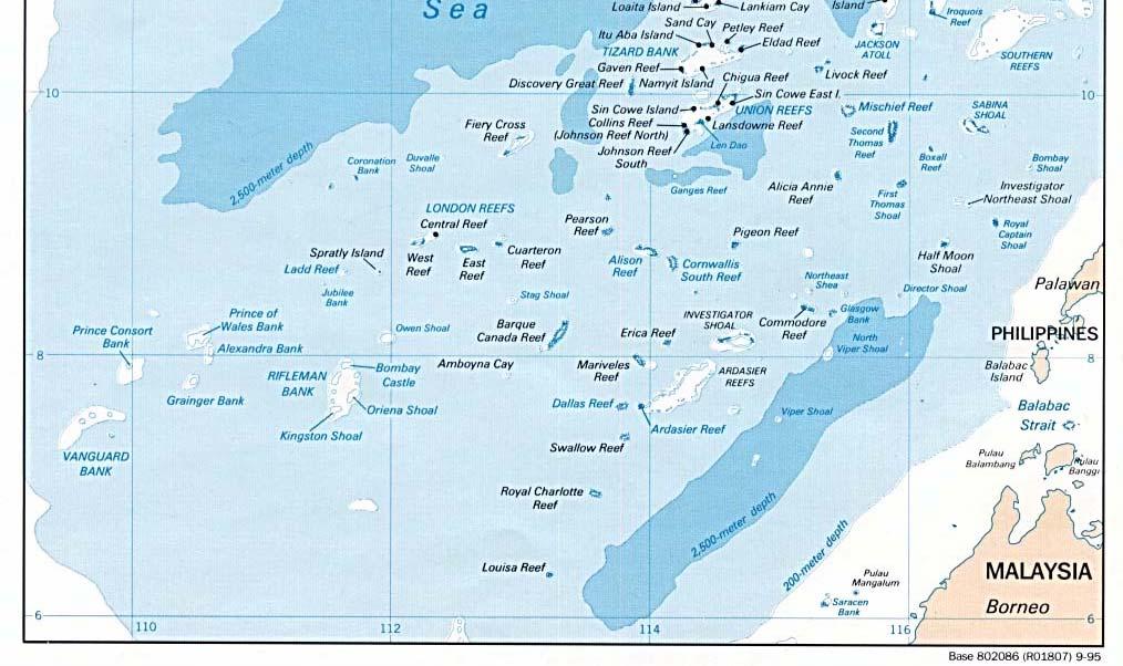
45 Figure 4 Spratly Islands Source: 44

46 Figure 5 Hypothetical EEZ of the Spratlys Source: Centre for Naval Analyses and the Institute for National Strategic Studies 45
CONVENTION ON THE TERRITORIAL SEA AND THE CONTIGUOUS ZONE
 CONVENTION ON THE TERRITORIAL SEA AND THE CONTIGUOUS ZONE THE STATES PARTIES TO THIS CONVENTION HAVE AGREED as follows: PART I TERRITORIAL SEA SECTION I GENERAL Article 1 1. The sovereignty of a State
UNITED NATIONS CONVENTION ON THE LAW OF THE SEA. Signed at Montego Bay, Jamaica, 10 December Entry into force: 16 November 1994
 UNITED NATIONS CONVENTION ON THE LAW OF THE SEA Signed at Montego Bay, Jamaica, 10 December 1982 Entry into force: 16 November 1994 The States Parties to this Convention, Prompted by the desire to settle,
Basic Maritime Zones. Scope. Maritime Zones. Internal Waters (UNCLOS Art. 8) Territorial Sea and Contiguous Zone
 Territorial Sea and Contiguous Zone") Basic Maritime Zones Dr Sam Bateman (University of Wollongong, Australia) Scope Territorial Sea and Contiguous Zone Territorial sea baselines Innocent passage Exclusive Economic Zones Rights and duties
Basic Maritime Zones Dr Sam Bateman (University of Wollongong, Australia) Scope Territorial Sea and Contiguous Zone Territorial sea baselines Innocent passage Exclusive Economic Zones Rights and duties
Law of the Sea. CDR James Kraska, JAGC, USN Howard S. Levie Chair of Operational Law
 Law of the Sea CDR James Kraska, JAGC, USN Howard S. Levie Chair of Operational Law Enduring Forward Presence Deterrence Sea Control Power Projection Expanding Maritime Security Humanitarian Assistance
THE LEGAL REGIME OF STRAITS USED FOR INTERNATIONAL NAVIGATION
 THE LEGAL REGIME OF STRAITS USED FOR INTERNATIONAL NAVIGATION Institute of Diplomacy and Foreign Relations (IDFR) IDFR Maritime Seminar Series Straits of Malacca Kuala Lumpur, 10 November 2009 Professor
Federal Law No. 19 of 1993 in respect of the delimitation of the maritime zones of the United Arab Emirates, 17 October 1993
 Page 1 Federal Law No. 19 of 1993 in respect of the delimitation of the maritime zones of the United Arab Emirates, 17 October 1993 We, Zayed bin Sultan Al Nahayyan, the President of the United Arab Emirates,
Unit 3 (under construction) Law of the Sea
 Law of the Sea") Unit 3 (under construction) Law of the Sea Law of the Sea, branch of international law concerned with public order at sea. Much of this law is codified in the United Nations Convention on the Law of the
Unit 3 (under construction) Law of the Sea Law of the Sea, branch of international law concerned with public order at sea. Much of this law is codified in the United Nations Convention on the Law of the
United Nations Conference on the Law of the Sea
 United Nations Conference on the Law of the Sea Geneva, Switzerland 24 February to 27 April 1958 Documents: A/CONF.13/C.1/L.52-L.85 Annexes Extract from the Official Records of the United Nations Conference
The Legal Regime Governing Passage on Routes used for International Navigation through Indonesian Waters. Robert Beckman
 42 nd Annual Conference of the Center for Oceans Law & Policy Cooperation and Engagement in the Asia Pacific Region Beijing, China, 24-26 May 2018 Panel 4: Straits Governance The Legal Regime Governing
UNITED NATIONS CONVENTION ON THE LAW OF THE SEA 1982 A COMMENTARY
 UNITED NATIONS CONVENTION ON THE LAW OF THE SEA 1982 A COMMENTARY UNITED NATIONS CONVENTION ON THE LAW OF THE SEA 1982 A COMMENTARY Myron H. Nordquist, Editor-in-Chief Satya N. Nandan and Shabtai Rosenne,
United Nations Convention on the Law of the Sea
 7 United Nations Convention on the Law of the Sea CONTENTS Page PREAMBLE... 21 PART I. INTRODUCTION... 22 Article 1. Use of terms and scope... 22 PART II. TERRITORIAL SEA AND CONTIGUOUS ZONE... 23 SECTION
Environmental Protection in Archipelagic Waters and International Straits-The Role of the International Maritime Organisation
 University of Miami Law School University of Miami School of Law Institutional Repository Articles Faculty and Deans 1995 Environmental Protection in Archipelagic Waters and International Straits-The Role
I. Is Military Survey a kind of Marine Scientific Research?
 On Dissection of Disputes Between China and the United States over Military Activities in Exclusive Economic Zone by the Law of the Sea Jin Yongming (Institute of Law, Shanghai Academy of Social Sciences,
Captain J. Ashley Roach, JAGC, USN (ret.) Office of the Legal Adviser U.S. Department of State (retired) Senior Visiting Scholar, CIL NUS ARF Seminar
 Office of the Legal Adviser U.S. Department of State (retired) Senior Visiting Scholar, CIL NUS ARF Seminar") Captain J. Ashley Roach, JAGC, USN (ret.) Office of the Legal Adviser U.S. Department of State (retired) Senior Visiting Scholar, CIL NUS ARF Seminar on UNCLOS Session 2.3 Manila May 28, 2014 Importance
Captain J. Ashley Roach, JAGC, USN (ret.) Office of the Legal Adviser U.S. Department of State (retired) Senior Visiting Scholar, CIL NUS ARF Seminar on UNCLOS Session 2.3 Manila May 28, 2014 Importance
Law No. 28 (1) Chapter I Definitions
 Chapter I Definitions") Page 1 Law No. 28 (1) The President of the Republic, Pursuant to the provisions of the Constitution and the decision of the People's Assembly taken at its session held on 13 Ramadan 1424 A.H., corresponding
Page 1 Law No. 28 (1) The President of the Republic, Pursuant to the provisions of the Constitution and the decision of the People's Assembly taken at its session held on 13 Ramadan 1424 A.H., corresponding
THE PHILIPPINE BASELINES LAW
 THE PHILIPPINE BASELINES LAW by Michael Garcia Tokyo, Japan 13 April 3009 Outline Introduction Legal Framework Extended Continental Shelf Options for establishing Philippine baselines Reactions to the
South China Sea- An Insight
 South China Sea- An Insight Historical Background China laid claim to the South China Sea (SCS) back in 1947. It demarcated its claims with a U-shaped line made up of eleven dashes on a map, covering most
Maritime Zones Act, 1999 (Act No. 2 of 1999) PART I PRELIMINARY
 PART I PRELIMINARY") Page 1 Maritime Zones Act, 1999 (Act No. 2 of 1999) AN ACT to repeal the Maritime Zones Act (Cap 122) and to provide for the determination of the Maritime Zones of Seychelles in accordance with the United
Page 1 Maritime Zones Act, 1999 (Act No. 2 of 1999) AN ACT to repeal the Maritime Zones Act (Cap 122) and to provide for the determination of the Maritime Zones of Seychelles in accordance with the United
Tara Davenport Research Fellow Centre for International Law
 Maritime Security in Southeast Asia: Maritime Governance Session 3 Provisional Arrangements of a Practical Nature: Problems and Prospects in Southeast Asia Tara Davenport Research Fellow Centre for International
This document is downloaded from DR-NTU, Nanyang Technological University Library, Singapore.
 This document is downloaded from DR-NTU, Nanyang Technological University Library, Singapore. Title Who governs the South China Sea? Author(s) Rosenberg, David Citation Rosenberg, D. (2016). Who governs
Game Changer in the Maritime Disputes
 www.rsis.edu.sg No. 180 18 July 2016 RSIS Commentary is a platform to provide timely and, where appropriate, policy-relevant commentary and analysis of topical issues and contemporary developments. The
South China Sea: Realpolitik Trumps International Law
 South China Sea: Realpolitik Trumps International Law Emeritus Professor Carlyle A. Thayer Presentation to East Asian Economy and Society, Institut für Ostasienwissenschaften Universität Wien Vienna, November
Romania. ACT concerning the Legal Regime of the Internal Waters, the Territorial Sea and the Contiguous Zone of Romania, 7 August 1990 * CHAPTER I
 Romania ACT concerning the Legal Regime of the Internal Waters, the Territorial Sea and the Contiguous Zone of Romania, 7 August 1990 * [Original: Romanian] CHAPTER I The territorial sea and the internal
Geopolitics, International Law and the South China Sea
 THE TRILATERAL COMMISSION 2012 Tokyo Plenary Meeting Okura Hotel, 21-22 April 2012 EAST ASIA I: GEOPOLITICS OF THE SOUTH CHINA SEA SATURDAY 21 APRIL 2012, ASCOT HALL, B2F, SOUTH WING Geopolitics, International
The Maritime Areas Act, 1984 Act No. 3 of 30 August 1984
 Page 1 The Maritime Areas Act, 1984 Act No. 3 of 30 August 1984 AN Act to make provision with respect to the territorial sea and the continental shelf of Saint Kitts and Nevis; to establish a contiguous
Vietnam s First Maritime Boundary Agreement
 74 Articles Section Vietnam s First Maritime Boundary Agreement Nguyen Hong Trao Introduction On 9 August 1997, in Bangkok, the Foreign Minister of the Socialist Republic of Vietnam (SRV), His Excellency
Disputed Areas in the South China Sea
 Diplomatic Academy of Vietnam The 5 th International Workshop The South China Sea: Cooperation for Regional Security and Development 10-12 November, 2013, Hanoi, Viet Nam Vietnam Lawyers Association Disputed
12 August 2012, Yeosu EXPO, Republic of Korea. Session I I Asia and UNCLOS: Progress, Practice and Problems
 2012 Yeosu International Conference Commemorating the 30 th Anniversary of the Opening for Signature of the United Nations Convention on the Law of the Sea 12 August 2012, Yeosu EXPO, Republic of Korea
Can the COC Establish a Framework for a Cooperative Mechanism in the South China Sea? Robert Beckman
 9 th South China Sea International Conference: Cooperation for Regional Security & Development 27-28 Nov 2017, Ho Chi Minh City, Viet Nam Session 7: Panel Discussion: Code of Conduct (COC): Substance and
A Brief of Cambodia s Claims to Baselines and Maritime Zones By: Dany Channraksmeychhoukroth* (Aug 2015)
") A Brief of Cambodia s Claims to Baselines and Maritime Zones By: Dany Channraksmeychhoukroth* (Aug 2015) Cambodia was under French colonization for 90 years from 1863 until 1953. Beside the 1907 Franco-
A Brief of Cambodia s Claims to Baselines and Maritime Zones By: Dany Channraksmeychhoukroth* (Aug 2015) Cambodia was under French colonization for 90 years from 1863 until 1953. Beside the 1907 Franco-
Maritime Areas Act of 1996
 Page 1 Maritime Areas Act of 1996 Arrangement of sections Preliminary 1. Short title. 2. Interpretation. 3. Declaration of Archipelagic State. 4. Internal Waters. Declaration of Archipelagic State Internal
Baltic Marine Environment Protection Commission
 Baltic Marine Environment Protection Commission Revised HELCOM RECOMMENDATION 31E/5 Adopted 20 May 2010, having regard to Article 20, Paragraph 1 b) of the Helsinki Convention Revised 6 March 2014, having
United Nations Conference on the Law of the Sea
 United Nations Conference on the Law of the Sea Geneva, Switzerland 24 February to 27 April 1958 Documents: A/CONF.13/C.1/L.3-L.35 Annexes Extract from the Official Records of the United Nations Conference
Some legal aspects of the drilling rig incident in the South China Sea in
 China. 6 Vietnam asserted that the locations were within Vietnam s exclusive Some legal aspects of the drilling rig incident in the South China Sea in 2014 1 Pham Lan Dung 2 1. The positioning of the drilling
BELIZE MARITIME AREAS ACT CHAPTER 11 REVISED EDITION 2000 SHOWING THE LAW AS AT 31ST DECEMBER, 2000
 BELIZE MARITIME AREAS ACT CHAPTER 11 REVISED EDITION 2000 SHOWING THE LAW AS AT 31ST DECEMBER, 2000 This is a revised edition of the law, prepared by the Law Revision Commissioner under the authority of
Which High Seas Freedoms Apply in the Exclusive Economic Zone? *
 Law of the Sea Interest Group American Society of International Law Which High Seas Freedoms Apply in the Exclusive Economic Zone? * Raul Pete Pedrozo ** I. INTRODUCTION. II. COASTAL STATE RIGHTS AND JURISDICTION.
A BILL FOR [SB. 240] [ ] Maritime Zones 2009 No. C 31. An Act to Repeal the Exclusive Economic Zone Act Cap. E17 LFN 2004 and the
![A BILL FOR [SB. 240] [ ] Maritime Zones 2009 No. C 31. An Act to Repeal the Exclusive Economic Zone Act Cap. E17 LFN 2004 and the](/thumbs/95/124432694.jpg "A BILL FOR [SB. 240] [ ] Maritime Zones 2009 No. C 31. An Act to Repeal the Exclusive Economic Zone Act Cap. E17 LFN 2004 and the") [SB. 0] A BILL FOR Maritime Zones 00 No. C [Executive] An Act to Repeal the Exclusive Economic Zone Act Cap. E LFN 00 and the Territorial Waters Act Cap. TS LPN 00 and Enact the Maritime Zones Act to Provide
[SB. 0] A BILL FOR Maritime Zones 00 No. C [Executive] An Act to Repeal the Exclusive Economic Zone Act Cap. E LFN 00 and the Territorial Waters Act Cap. TS LPN 00 and Enact the Maritime Zones Act to Provide
and the role of Japan
 1 Prospect for change in the maritime security situation in Asia and the role of Japan Maritime Security in Southeast and Southwest Asia IIPS International Conference Dec.11-13, 2001 ANA Hotel, Tokyo Masahiro
Yan YAN, National Institute for South China Sea Studies, China. Draft Paper --Not for citation and circulation
 The 10 th CSCAP General Conference Confidence Building in the Asia Pacific: The Security Architecture of the 21 st Century October 21-23, 2015 Ulaanbaatar, Mongolia Yan YAN, National Institute for South
TERRITORIAL SEA AND EXCLUSIVE ECONOMIC ZONE ACT
 C T TERRITORIAL SEA AND EXCLUSIVE ECONOMIC ZONE ACT Terririal Sea and Exclusive Economic Zone Act CAP. 01.21 Arrangement of Sections C T TERRITORIAL SEA AND EXCLUSIVE ECONOMIC ZONE ACT Arrangement of
Prof T Ikeshima. LLB, LLM, DES, PhD. 03/06/2016 Session 1 (Ikeshima) 1
 1") Prof T Ikeshima LLB, LLM, DES, PhD 03/06/2016 Session 1 (Ikeshima) 1 Outline Arctic coastal states and the Arctic Ocean Russia The law of the sea as applicable law in the NSR Some legal issues under the
Prof T Ikeshima LLB, LLM, DES, PhD 03/06/2016 Session 1 (Ikeshima) 1 Outline Arctic coastal states and the Arctic Ocean Russia The law of the sea as applicable law in the NSR Some legal issues under the
ASEAN & the South China Sea Disputes
 Asian Studies Centre, St Antony s College University of Oxford China Centre 19-20 October 2017 Session V, Friday 20 th, 11.15-12.45 ASEAN & the South China Sea Disputes Robert Beckman Head, Ocean Law and
Federal Act relating to the Sea, 8 January 1986
 Page 1 Federal Act relating to the Sea, 8 January 1986 The Congress of the United Mexican States decrees: TITLE I General Provisions CHAPTER I Scope of application of the Act Article 1 This Act establishes
Definition of key terms
 Committee: Security Council Issue title: Terriotorial disputes over the South China Sea Submitted by: Stuart Verkek, Deputy President of Security Council Edited by: Kamilla Tóth, President of the General
The Nomocracy Pursuit of the Maritime Silk Road On Legal Guarantee of State s Marine Rights and Interests
 Journal of Shipping and Ocean Engineering 6 (2016) 123-128 doi 10.17265/2159-5879/2016.02.007 D DAVID PUBLISHING The Nomocracy Pursuit of the Maritime Silk Road On Legal Guarantee of State s Marine Rights
Page 1. Arrangements of Sections PART I PRELIMINARY. 1. Short title and commencement. 2. Interpretation. PART II MARITIME AREAS OF BELIZE
 Page 1 Maritime Areas Act, 1992 (An Act to make provision with respect to the Territorial Sea, Internal Waters and the Exclusive Economic Zone of Belize; and for matters connected therewith or incidental
Joint Marine Scientific Research in Intermediate/Provisional
 Joint Marine Scientific Research in Intermediate/Provisional Zones between Korea and Japan Chang-Wee Lee(Daejeon University) & Chanho Park(Pusan University) 1. Introduction It has been eight years since
The Legal Regime of Maritime Areas and the Waning Freedom of the Seas
 www.maritimeissues.com The Legal Regime of Maritime Areas and the Waning Freedom of the Seas HELMUT TUERK Abstract: The principle of the freedom of the seas dates back to the early 17 th century. The balance
TITLE 33. MARINE ZONES AND PROTECTION OF MAMMALS
 TITLE 33. MARINE ZONES AND PROTECTION OF MAMMALS CHAPTER 1. MARINE ZONES ARRANGEMENT OF SECTIONS Section PART I - PRELIMINARY 109. The Contiguous zone. 101. Short Title. 110. Legal Character of Marine
The Belt and Road Initiative: The China-Philippines relation in the South China Sea beyond the Arbitration
 The Belt and Road Initiative: The China-Philippines relation in the South China Sea beyond the Arbitration Professor Vasco Becker-Weinberg Faculty of Law of the Universidade NOVA de Lisboa The Belt and
I. Background: An Exclusive Economic Zone (EEZ) is an area of water a certain distance off the coast where countries have sovereign rights to
 is an area of water a certain distance off the coast where countries have sovereign rights to") South China Seas Edison Novice Committee I. Background: An Exclusive Economic Zone (EEZ) is an area of water a certain distance off the coast where countries have sovereign rights to economic ventures
South China Seas Edison Novice Committee I. Background: An Exclusive Economic Zone (EEZ) is an area of water a certain distance off the coast where countries have sovereign rights to economic ventures
CHAPTER 100:01 MARITIME BOUNDARIES ACT ARRANGEMENT OF SECTIONS PART I PART II
 Maritime Boundaries 3 CHAPTER 100:01 MARITIME BOUNDARIES ACT ARRANGEMENT OF SECTIONS SECTION 1. Short title. 2. Interpretation. PART I THE TERRITORIAL SEA 3. Territorial Sea. 4. Internal waters. 5. Sovereignty
UNITED NATIONS CONVENTION ON THE LAW OF THE SEA
 UNITED NATIONS CONVENTION ON THE LAW OF THE SEA By Tullio Treves Judge of the International Tribunal for the Law of the Sea, Professor at the University of Milan, Italy The United Nations Convention on
MARITIME BOUNDARY DISPUTES AMONG ASEAN MEMBER COUNTRIES: COULD ASEAN DO SOMETHING? Amrih Jinangkung
 MARITIME BOUNDARY DISPUTES AMONG ASEAN MEMBER COUNTRIES: COULD ASEAN DO SOMETHING? Amrih Jinangkung Background Cambodia Thailand dispute is an example of how a longstanding unresolved boundary dispute
TOF WHITE PAPER - SECTION re EXTENDED CONTINENTAL SHELF
 TOF WHITE PAPER - SECTION re EXTENDED CONTINENTAL SHELF Introduction The 1982 United Nations Convention on the Law of the Sea (UNCLOS or the Convention), which went into effect in 1994, established a comprehensive
Recent Developments in the South China Sea: Reclamation, Navigation and Arbitration
 Recent Developments in the South China Sea: Reclamation, Navigation and Arbitration EIAS Briefing Seminar 16 June 2016 The South China Sea, through which USD 5.3 trillion worth of maritime trade passes
Prospects for the Code of Conduct in the South China Sea after Hague decision
 Prospects for the Code of Conduct in the South China Sea after Hague decision by Richard Q. Turcsányi, PhD. On 12 July 2016, the Permanent Arbitration Court in The Hague issued the final decision in the
THE LEGAL REGIME OF STRAITS
 THE LEGAL REGIME OF STRAITS The right of transit passage in straits and the analogous right of archipelagic sea lanes passage in archipelagic States, negotiated in the 1970s and embodied in the 1982 UNCLOS,
HARMUN Chair Report. The Question of the South China Sea. Head Chair -William Harding
 HARMUN Chair Report The Question of the South China Sea Head Chair -William Harding will_harding@student.aishk.edu.hk Introduction Placed in between the Taiwan Strait and the Straits of Malacca Straits
This article from Hague Justice Journal is published by Eleven international publishing and made available to anonieme bezoeker
 COMMENTARY The Guyana/Suriname Arbitration: A Commentary Dr. Yoshifumi Tanaka * 1. INTRODUCTION Guyana and Suriname are situated on the northeast coast of the South American continent, and the coastlines
International Conference on Maritime Challenges and Market Opportunities August 28, 2017
 International Conference on Maritime Challenges and Market Opportunities August 28, 2017 John A. Burgess, Professor of Practice Fletcher School of Law and Diplomacy A Tale of Two Seas The Arctic and the
THE INTERNATIONAL LEGAL FRAMEWORK FOR RESCUE AT SEA By: Prof. Dr. Hasjim Djalal, M.A.
 THE INTERNATIONAL LEGAL FRAMEWORK FOR RESCUE AT SEA By: Prof. Dr. Hasjim Djalal, M.A. 1. According to customary international law, the states, through the ships flying their flag, are obliged to help rescue
Defining EEZ claims from islands: A potential South China Sea change
 University of Wollongong Research Online Faculty of Law, Humanities and the Arts - Papers Faculty of Law, Humanities and the Arts 2014 Defining EEZ claims from islands: A potential South China Sea change
Tokyo, February 2015
 The Rule of Law in the Seas of Asia - Navigational Chart for Peace and Stability - Compulsory Dispute Settlement Procedures under UNCLOS - Their Achievements and New Agendas - Tokyo, 12-13 February 2015
INTERNATIONAL TERRITORIAL DISPUTES AND CONFRONTATIONS IN THE SOUTH CHINA SEA FROM A LEGAL PERSPECTIVE
 INTERNATIONAL TERRITORIAL DISPUTES AND CONFRONTATIONS IN THE SOUTH CHINA SEA FROM A LEGAL PERSPECTIVE Yurika ISHII (Dr.) National Defense Academy of Japan eureka@nda.ac.jp INTRODUCTION (1) Q: What is the
This report is published and distributed by America s Survival, Inc. Cliff Kincaid, President
 This report is published and distributed by America s Survival, Inc. Cliff Kincaid, President. Kincaid@comcast.net 443-964-8208 The House of Representatives and the U.N. Convention on the Law of the Sea
The South China Sea Territorial Disputes in ASEAN-China Relations Aileen S.P. Baviera, University of the Philippines
 The South China Sea Territorial Disputes in ASEAN-China Relations Aileen S.P. Baviera, University of the Philippines Recent events call attention to the territorial disputes in the South China Sea as a
Basics of International Law of the Sea
 Basics of International Law of the Sea ReCAAP ISC Capacity Building Workshop 2018 4 September 2018, Yangon, Myanmar Zhen Sun Research Fellow, Centre for International Law http://www.recaap.org/reports
Grenada Territorial Waters Act, No. 17 of 1978
 Page 1 Grenada Territorial Waters Act, No. 17 of 1978 Short title and commencement 1. This Act may be cited as the GRENADA TERRITORIAL WATERS ACT, 1978, and shall come into force on such day as the Minister
} { THE PRESIDENT OF THE UNITED STATES MESSAGE AGREEMENT WITH THE UNION OF SOVIET SOCIALIST REPUBLICS ON THE MARITIME BOUNDARY
 } { 101ST CONGRESS TREATY DOC. SENATE 2d Session 101-22 AGREEMENT WITH THE UNION OF SOVIET SOCIALIST REPUBLICS ON THE MARITIME BOUNDARY MESSAGE FROM THE PRESIDENT OF THE UNITED STATES TRANSMITTING THE
CHAPTER 2. MARINE ZONES ARRANGEMENT OF SECTIONS
 ARRANGEMENT OF SECTIONS Section PART I- PRELIMINARY I. Short title. 2. Interpretation. 3. References to rules of international law. 4. Application of this Act. PART II THE S. Internal waters. 6. Archipelagic
1. Article 80, paragraph 1, of the Rules of the Court provides:
 SEPARATE OPINION OF JUDGE DONOGHUE Article 80, paragraph 1, of the Rules of Court Jurisdiction over counter-claims Termination of the title of jurisdiction taking effect after the filing of the Application
The Territorial Sea and Exclusive Economic Zone Act, Act No. 30 of 23 October 1978, as amended by Act No. 19 of 1989
 Page 1 The Territorial Sea and Exclusive Economic Zone Act, Act No. 30 of 23 October 1978, as amended by Act No. 19 of 1989 Short title and commencement 1. (1) This Act may be cited as The Territorial
Submarine Cables & Pipelines under UNCLOS
 HIELC 2016 Bucerius Law School Hamburg 15 April 2016 Submarine Cables & Pipelines under UNCLOS Robert Beckman Director, Centre for International Law (CIL) National University of Singapore Part 1 UNCLOS
Dr Fraser Cameron Director EU-Asia Centre, Brussels
 Dr Fraser Cameron Director EU-Asia Centre, Brussels Importance of SCS The SCS is the largest maritime route after the Mediterranean and a vital corridor for EU trade to and from East Asia - 25% of world
Japan s Position as a Maritime Nation
 Prepared for the IIPS Symposium on Japan s Position as a Maritime Nation 16 17 October 2007 Tokyo Session 1 Tuesday, 16 October 2007 Maintaining Maritime Security and Building a Multilateral Cooperation
INTERNATIONAL SYMPOSIUM ON THE LAW OF THE SEA. The Rule of Law in the Seas of Asia: Navigational Chart for the Peace and Stability
 (Check against delivery) INTERNATIONAL SYMPOSIUM ON THE LAW OF THE SEA The Rule of Law in the Seas of Asia: Navigational Chart for the Peace and Stability 12-13 February, 2015 Keynote Speech by Judge Shunji
This document is downloaded from DR-NTU, Nanyang Technological University Library, Singapore.
 This document is downloaded from DR-NTU, Nanyang Technological University Library, Singapore. Title UNCLOS and its Limitations as the Foundation for a Regional Maritime Security Regime Author(s) Sam, Bateman
East Asian Maritime Disputes and U.S. Interests. Presentation by Michael McDevitt
 East Asian Maritime Disputes and U.S. Interests Presentation by Michael McDevitt Worlds top ports by total cargo 2012 1. Shanghai, China (ECS) 744 million tons 2. Singapore (SCS) 537.6 3. Tianjin, China
Committee Introduction. Background Information
 Committee: Disarmament and International Security (DISEC) Agenda: Peaceful yet effective solutions to the territorial disputes in the South China Sea Written by: 정윤철, 박진원 Committee Introduction The Disarmament
Treaty on the Southeast Asia Nuclear-Weapon-Free Zone (Bangkok Treaty)
") Treaty on the Southeast Asia Nuclear-Weapon-Free Zone (Bangkok Treaty) The States Parties to this Treaty: DESIRING to contribute to the realization of the purposes and principles of the Charter of the
Treaty on the Southeast Asia Nuclear-Weapon-Free Zone (Bangkok Treaty) The States Parties to this Treaty: DESIRING to contribute to the realization of the purposes and principles of the Charter of the
Territorial Waters Act, No (1)
") Page 1 Territorial Waters Act, No. 1977-26(1) Short title 1. This Act may be cited as the Barbados Territorial Waters Act, 1977. 2. For the purposes of this Act: Interpretation "Competent Authority" means
Page 1 Territorial Waters Act, No. 1977-26(1) Short title 1. This Act may be cited as the Barbados Territorial Waters Act, 1977. 2. For the purposes of this Act: Interpretation "Competent Authority" means
Legislation Defining Louisiana's Coastal Boundaries
 Louisiana Law Review Volume 15 Number 1 Survey of 1954 Louisiana Legislation December 1954 Legislation Defining Louisiana's Coastal Boundaries Victor A. Sachse Repository Citation Victor A. Sachse, Legislation
The Disputes in the South China Sea -From the Perspective of International Law 1. The essence of the disputes in the South China Sea
 The Disputes in the South China Sea -From the Perspective of International Law (Forum on South China Sea, 16-17 October 2011, Manila) Draft only, no citation without the express consent of the author GAO
CENTRE FOR INTERNATIONAL LAW. Conference on Joint Development and the South China Sea June 2011, Grand Copthorne Hotel, Singapore
 CENTRE FOR INTERNATIONAL LAW Conference on Joint Development and the South China Sea 16 17 June 2011, Grand Copthorne Hotel, Singapore Conference Report by Tara Davenport, Ian Townsend-Gault, Robert Beckman,
IMPLICATIONS OF THE UNITED NATIONS CONVENTION ON THE LAW OF THE SEA FOR THE INTERNATIONAL MARITIME ORGANIZATION
 E LEG/MISC.7 19 January 2012 IMPLICATIONS OF THE UNITED NATIONS CONVENTION ON THE LAW OF THE SEA FOR THE INTERNATIONAL MARITIME ORGANIZATION Study by the Secretariat of the International Maritime Organization
GUIDELINES FOR REGIONAL MARITIME COOPERATION
 MEMORANDUM 4 GUIDELINES FOR REGIONAL MARITIME COOPERATION Introduction This document puts forward the proposed Guidelines for Regional maritime Cooperation which have been developed by the maritime Cooperation
Maritime Law Association of South Africa Conference Shelley Point 15 September 2012
 Webber Wentzel 2012 Maritime Law Association of South Africa Conference Shelley Point 15 September 2012 PLACES OF REFUGE FOR SHIPS IN NEED OF ASSISTANCE an international overview Patrick Holloway 5379525_1
Thailand s Contribution to the Regional Security By Captain Chusak Chupaitoon
 Thailand s Contribution to the Regional Security By Captain Chusak Chupaitoon Introduction The 9/11 incident and the bombing at Bali on 12 October 2002 shook the world community and sharpened it with the
IN THE HON BLE INTERNATIONAL COURT OF JUSTICE, HEGUE IN THE MATTER OF (AEGEAN SEA CONTINENTAL SHELF CASE) GREECE... APPELLANT TURKEY...
 GREECE... APPELLANT TURKEY...") IN THE HON BLE INTERNATIONAL COURT OF JUSTICE, HEGUE IN THE MATTER OF (AEGEAN SEA CONTINENTAL SHELF CASE) GREECE.... APPELLANT Vs TURKEY.... RESPONDENT SUBMITTED BEFORE THE HON BLE COURT IN EXCERSISE OF
IN THE HON BLE INTERNATIONAL COURT OF JUSTICE, HEGUE IN THE MATTER OF (AEGEAN SEA CONTINENTAL SHELF CASE) GREECE.... APPELLANT Vs TURKEY.... RESPONDENT SUBMITTED BEFORE THE HON BLE COURT IN EXCERSISE OF
Foster: New Zealand's Coastal Jurisdiction NEW ZEALAND'S COASTAL JURISDICTION
 Foster: New Zealand's Coastal Jurisdiction NEW ZEALAND'S COASTAL JURISDICTION WILLIAM F. FOSTER* I. INTRODUCTION The purpose of this note is to outline and comment upon the position of New Zealand on the
International Environmental Law JUS 5520
 The Marine Environment, Marine Living Resources and Marine Biodiversity International Environmental Law JUS 5520 Dina Townsend dina.townsend@jus.uio.no Pacific Fur Seal Case 1 Regulating the marine environment
PART 1 - checklists Course breakdown
 PART 1 - checklists Course breakdown 1) Nature + customary international law 2) Law of treaties + other sources of international law 3) Sovereignty and territory 4) Maritime jurisdiction 5) State responsibilities
THE SOUTH CHINA SEA: EVERY NATION FOR ITSELF
 THE SOUTH CHINA SEA: EVERY NATION FOR ITSELF A Monograph by MAJ Thomas A. Elmore United States Army School of Advanced Military Studies United States Army Command and General Staff College Fort Leavenworth,
South China Sea Arbitration and its Application to Dokdo
 University of Wollongong Research Online Faculty of Law, Humanities and the Arts - Papers Faculty of Law, Humanities and the Arts 2018 South China Sea Arbitration and its Application to Dokdo Seokwoo Lee
FIFTH REGULAR SESSION, 2016 C.B. NO A BILL FOR AN ACT
 NINETEENTH CONGRESS OF THE FEDERATED STATES OF MICRONESIA FIFTH REGULAR SESSION, C.B. NO. - A BILL FOR AN ACT To amend sections,,,,, and of title of the Code of the Federated States of Micronesia (Annotated),
THE GOVERNMENT REPUBLIC OF INDONESIA ACT OF THE REPUBLIC OF INDONESIA NUMBER : 6 OF 1996 DATED: AUGUST 8, 1996 INDONESIAN WATERS
 2 THE GOVERNMENT REPUBLIC OF INDONESIA ACT OF THE REPUBLIC OF INDONESIA NUMBER : 6 OF 1996 DATED: AUGUST 8, 1996 RE INDONESIAN WATERS THE PRESIDENT OF THE REPUBLIC OF INDONESIA, Considering a. that based
Foreign Military Research in a Coastal State s Maritime Zones Preliminary Analysis
 Foreign Military Research in a Coastal State s Maritime Zones Preliminary Analysis By R. Douglas Brubaker i FNI Report 8/2001 FRIDTJOF NANSENS INSTITUTT THE FRIDTJOF NANSEN INSTITUTE Tittel/Title Foreign
Legal and Geographical Implications of the South China Sea Arbitration
 1 Legal and Geographical Implications of the South China Sea Arbitration Clive Schofield Director of Research Australian National Centre for Ocean Resources and Security (ANCORS) University of Wollongong
The Association of the Bar of the City of New York
 The Association of the Bar of the City of New York Office of the President PRESIDENT Bettina B. Plevan (212) 382-6700 Fax: (212) 768-8116 bplevan@abcny.org www.abcny.org September 19, 2005 Hon. Richard