Census Limerick Metropolitan Area Socio-Economic and Demographic Profile
|
|
|
- Imogene Collins
- 6 years ago
- Views:
Transcription


1 Census 2016 Limerick Metropolitan Area Socio-Economic and Demographic Profile Helen Fitzgerald Co-ordinator Research, Monitoring and Communications, PAUL Partnership, Unit 25a Tait Business Centre, Dominic St. Limerick


2 Limerick Metropolitan Area - Key Trends and Findings Increasing population Outer suburban areas are the most populated Biggest population increases experienced in city centre area comprising of people of working age, with high percentage of non-irish nationals Biggest population declines in Regeneration areas Overall, relative affluence has improved, but not for all communities Approximately one-fifth of population live in areas classified as disadvantaged Regeneration and neighbouring communities have: Higher rates of unemployment Lower rates of educational attainment Higher rates of unskilled/low skilled workers Higher lone parent rates Higher age dependency rates Decreasing populations 1
 and Small Areas (SAs). EDs are the smallest legally defined administrative areas in the State.")
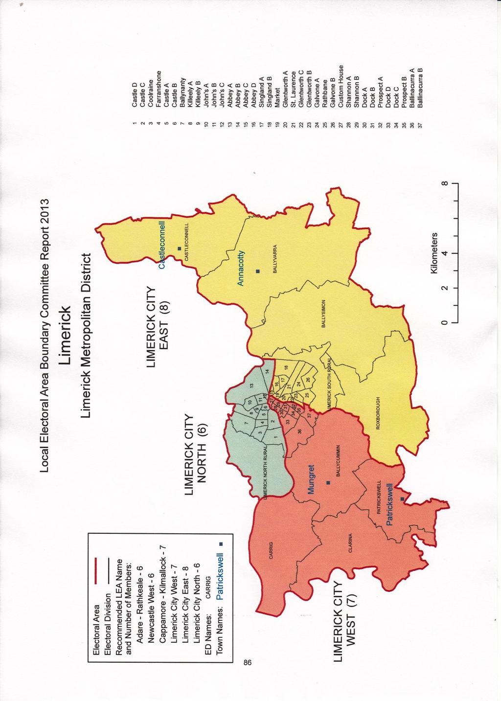
3 This report presents a socio-economic and demographic profile of the Limerick Metropolitan area, drawing on Census data 1. For the purpose of demographic analysis, the area can be divided into Electoral Divisions (EDs) and Small Areas (SAs). EDs are the smallest legally defined administrative areas in the State. The Limerick Metropolitan area is made up of 47 EDs in total. SAs are areas of population, located within EDs, comprising between 50 and 200 dwellings. They are the smallest geographic area for which Small Area Population Statistics (SAPS) are published from the Census. There are over 400 Small Areas in the Limerick Metropolitan area. In most cases in this section, communities are referred to by their ED name with explanations of approximate location provided. The following two maps showing the names and locations of all EDs in the city centre and surrounding area are a useful reference guide when reading this profile. Limerick City Centre Electoral Divisions 1 Not all Census 2016 data has been published yet at Small Area or Electoral Division level. This profile uses Census 2016 data that was publicly available at local area level during the tendering period. Four key resources were used to extract and analyse local area Census data and maps for this profile: 1. Central Statistics Office 2. Pobal Maps 3. Trutz Haase Deprivation Index 4. AIRO, Maynooth University Mapping Resources 2
4 3
5 Population As per the 2016 Census, the total population of the Limerick Metropolitan area is 104,952, up from 102,161 in 2011 an increase of just 2.7%. The Limerick Metropolitan area accounts for just over a half (54%) of the total population in the county of Limerick which has a total population of 194,899. Area Total Population Change Limerick Metropolitan Area 104,952 +3% Limerick County (incl. Metropolitan Area) 194, % The most densely populated community in the area is the Ballycummin ED which contains the residential estates of Raheen and Dooradoyle and has a population of 18,388. The next most populated ED is Ballysimon. It has a population of 13,590 and is comprised of the residential areas of Castletroy, Monaleen and parts of Annacotty as well as the more rural area just to the east of the M7 motorway. These two EDs alone account for 30% of the Limerick Metropolitan area population. After this, the next most populated areas in are: Limerick North Rural (Coonagh, Caherdavin, parts of Moyross) population of 6,801 Abbey A (Corbally) population of 4,636 Ballyvarra (Annacotty area) population of 4,288 Singland B (Lynwood Park, Norwood Park, Castletroy View ) population of 3,873 The remaining EDs range in population size from 4,214 (Dock C O Connell Avenue/South Circular Avenue area) to 456 (John s C Athlunkard St./George s Quay area). 18 EDs have populations of less than 1,000. These EDs are primarily the older, residential areas located closer to the city centre and include: Glentworth A (Sexton St., Upper Carey s Road) 554 residents Castle B (Clancy Strand and parts of Thomondgate) 488 residents John s C (Athlunkard St./George s Quay) 456 residents Population Change Analysis of 2011 and 2016 Census data reveals changing population patterns in the Limerick Metropolitan area. The city centre area has experienced significant change in population over the past 5 to 10 years. In particular, the EDs of Shannon A and Shannon B (covering the city centre streets between the Shannon river, William Street, Parnell Street, and Mallow Street) have 4
6 experienced population increases of 41% and 40% respectively since 2011, and by 117% and 78% since Likewise, the EDs of Dock A (Upper Henry St./Steamboat Quay area), Custom House (Ruthland St. to Watergate) and John s C (Athlunkard St./George s Quay), all located in or close to the city centre area, also saw large increases in population since 2011, as shown in the Table and Maps below. Custom House, Market (Upper Mulgrave St./Cathedral Place,) and Abbey B (Clare St./Rhebogue) have also experienced significant population increases over the past 10 years. EDs with Largest Population Increases & ED Population 2016 Change ED Population 2016 Change Shannon A % Shannon A % Shannon B % Shannon B % Dock A 2,339 30% Market 2,035 44% Custom House % Custom House % John's C % Abbey B 2,653 30% The next table lists the EDs that have experienced the highest levels of depopulation in the past 5 years, and in the 10 year period since Since 2006, the Regeneration communities of O Malley Park (Galvone B), St. Mary s Park (John s A) and Ballinacurra Weston (Prospect A and B) have seen significant decreases in population. In particular, the population of O Malley Park has fallen by 58% since Dock D (Dock Road, Upper Henry St., Summerville Avenue area) has also experienced a relatively large population decline. EDs with Largest Population Decreases & ED Population 2016 Change ED Population 2016 Change Galvone B % Galvone B % Prospect A % John s A % St. Laurence % Prospect B % John s A % Prospect A % Dock D % Dock D % The following Maps highlight the population changes since 2011 and since The EDs in the red have experienced the greatest depopulation and those in dark blue have experienced the largest increases in population. 5

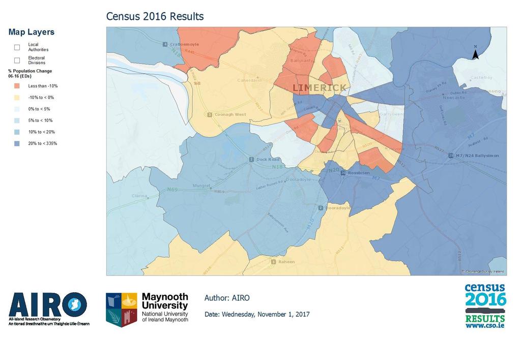
7 Population Change at ED Level Population Change at ED Level
 has the highest average age with 47.4, followed by Coolraine (Ennis Road to Brookville Ave, 46.6), Castle B (Clancy Strand, 45.")
8 Age Profile The average age for the Limerick City and County region, according to the 2016 Census, is 37.7, up from 36.5 in This mirrors the national average and trend which increased from 36.1 to 37.4 over the same period. Farranshone (Mayorstone/Shelbourne Road) has the highest average age with 47.4, followed by Coolraine (Ennis Road to Brookville Ave, 46.6), Castle B (Clancy Strand, 45.3), Ballinacurra B (Ballinacurra Gardens, Greenfields Road, 44.9), John s B (Nicholas St, Island Road, Lee Estate, 44). The city centre, Rhebogue, and the outer suburban communities of Castletroy, Raheen and Dooradoyle have a younger average age as shown by the lighter colours in the Map below. Average Age by ED The EDs with higher age averages generally have the largest proportions of people aged over 65 - ranging from 22% to 29% of their total population as shown in the map below. (The corresponding national rate for this age cohort is 19%), and include the EDs of: Coolraine (29%), Farranshone (28%), Castle B (26%), and Ballinacurra B (26%). 7
 has the highest proportion of children and young people (under 18 years) with 31.3% in this age group.")
9 Percentage Population Aged % of the national population is aged under 18. For Limerick City and County, this rate is 24.2%. In the Limerick Metropolitan area, Galvone B (O Malley Park) has the highest proportion of children and young people (under 18 years) with 31.3% in this age group. Limerick South Rural (includes parts of Old Cork Road and Castletroy View), Abbey B (Rhebogue), Prospect B (Ballinacurra Weston), Ballycummin (Raheen, Dooradoyle), John s A (John s A), Kileely A (Kileely), and Ballynanty (Moyross) also have high percentages of their population in this age bracket ranging from 26% to 30%, as shown in the map below. The city centre EDs of Shannon A and Shannon B have the lowest percentage of residents aged under 18. 8

10 Percentage Population Aged Under 18 Age Dependency Ratio The age dependency ratio shows the ratio of people aged under 14 and over 65 to people of working age (aged 15-64). The age dependency ratio at national level increased from 49.3% in 2011 to 52.7% in 2016, i.e. the number of people who are aged under 15 or over 65 is more than half the number of people who are of working age. The age dependency for Limerick city and county, according to the 2016 Census is at a similar rate of 52.4%, up from 48.2%. However, 20 EDs in the Limerick Metropolitan area have age dependency rates in excess of the national and county average. These include communities that have an older population, e.g. Farranshone 71%, Coolraine 70%, Ballinacurra B 69%, Castle B 68%. It also includes communities with a higher proportion of young people - Galvone B 71%. The EDs in and close to the city centre have the lowest overall dependency rates, as shown in the next Map. Shannon B and A have age dependency rates of 15% and 18% respectively. 9

11 Age Dependency Rates Employment and Unemployment The national unemployment rate, when calculated on Principal Economic Status (PES) 2, is 12.9%, down from 19% in Unemployment among males fell from 22.3% to 13.7%, while the rate among females fell from 15% to 12%. Unemployment rates remain higher among younger people with 21.8% of year olds unemployed in 2016, compared to 11.3% of year olds. The unemployment rate for the Limerick area has fallen since the 2011 Census in line with the national and county trend. The unemployment rate for Limerick City and County in 2016 is 14.4%, down from 21% in Unemployment Blackspots are defined by the Central Statistics Office as Electoral Divisions which have a labour market in excess of 200 people and an unemployment rate in excess of 27%. In 2016, 79 EDs in the country were classified as unemployment blackspots with an average unemployment rate of 31.2%. 18 of these blackspots are located in Limerick City and County (17 in the Metropolitan area). Of the 10 blackspots with the highest unemployment rates in the country, 8 are located in the 2 The CSO uses Principal Economic Data from the Census to calculate the unemployment rate as follows: Number of people looking for 1 st job plus the number of unemployed people having lost or given up last job calculated as a percentage of the total of number of people at work plus number of people looking for 1 st job plus the number of unemployed people having lost or given up last job. 10

12 Limerick Metropolitan area. These include: John's A (58.3%), Galvone B (45.0%), Ballynanty (43.6%), Abbey C (Pennywell, 41.9%) and Prospect B (40.7%), as shown in the Map below. The EDs around the Ennis Road area of the city - Castle D, Farranshone as well as the suburban communities of Annacotty, Castletroy, Corbally, Raheen and Dooradoyle have the lowest unemployment rates. John s A (St. Mary s Park) also has the highest rate of Male Unemployment in the Limerick Metropolitan area with 69.9% of the labour force not in employment, up from 61.5% in Galvone B (O Malley Park) has the second highest rate of male unemployment with a rate of 47.8%. However, this represents a significant improvement on the 2011 rate of 64.5%. At 45.8%, the ED of Ballynanty (containing parts of Moyross and Ballynanty) has the highest female unemployment rate (up from 40% in 2011). Galvone B has the second highest rate of female unemployment with 40.5% of the female labour force out of work. improvement on the 2011 rate of 44.2%. However, this is also an Unemployment Rate (Male and Female) Educational Attainment 13.5% of the population (over the age of 15) in Limerick City and County have left school with just a primary education or no formal education. This is just slightly higher than the national rate of 12.5%. 11
, Galvone B (39.4%), Glentworth C (Hyde Road area) (37.")
13 However, in many parts of the city, the proportion of the population who left school with just a primary education is considerably higher than the national average. In 18 EDs, the rate is 20% or higher, with 9 EDs recording an early school leaving rate in excess of 30%. This includes John s A (46.8%), Galvone B (39.4%), Glentworth C (Hyde Road area) (37.2%), Kileely A (35.7%), and Ballynanty (35.3%). Although with the exception of Prospect A, Kileely A and Ballynanty, the rates for these particular EDs have actually improved slightly since Percentage Population with No Formal or Primary Education Only However, in 15 EDs, the percentage of the total population who had left school with just a Junior Certificate or equivalent exceeds 50%. It is as high as 76% in John s A (St. Mary s Park), 65% in O Malley Park (Galvone B), and 61% in Glentworth C (Ballinacurra Weston/Prospect), Ballynanty, and Kileely A. 30% of the population (over the age of 15) in Limerick City and County have a Third Level qualification. This compares to a national average of 33.4%. However, in 18 EDs in the Metropolitan area, this rate is less 19%, and for 8 EDs, it is lower than 10%. Again, these include the EDs of John s A, Glentworth C, and Galvone B (all with rates of less than 5%), as well as Ballynanty, Kileely A, Rathbane, Prospect A and Singland A (Garryowen). However, despite the low rates overall, all but one ED among this group (Glentworth C) have seen the rate of third level attainment increase slightly from the 2011 Census. 12
14 Percentage Population with Third Level (Higher and Lower) Social Class The EDs of Castle C and Castle D (North Circular Road area) have the highest proportions of people in the Professional and Managerial social classes with 60.5% and 56.5% of their population respectively in these socio-economic classes. Seven EDs have less than 10% of their population in these two social classes, as shown in the Table below. The same seven EDs also have the highest percentage of people in the unskilled and semi-skilled social classes. 13 Social Class Professional and Managerial Electoral Division % Population John's A 4.0 Galvone B 7.1 Glentworth C 7.4 Prospect A 7.4 Ballynanty 8.3 Kileely A 8.4 Rathbane 8.7 Social Class Unskilled/Semi-Skilled Electoral Division % Population John's A 55.4 Glentworth C 49.7 Prospect A 49.6 Galvone B 41.2


15 Ballynanty 40.7 Rathbane 40.3 Kileely A 39.1 Social Class Professional Workers Social Class - Unskilled 14

16 Nationality 11% of the population nationally is comprised of people who reported their nationality as other than Irish in the 2016 Census. In Limerick City and County, the rate is 9.4%. As the Table below shows that more than half of the population in two EDs in the city centre Shannon A and Dock A - reported their nationality as other than Irish in the 2016 Census. Similarly, the city centre and neighbouring EDs of Shannon B, Custom House, Market, and Dock B also have large immigrant communities, with in excess of 40% of residents in these areas reporting their nationality as other than Irish. EDs with Largest Non-Irish Population Electoral Division % Non-Irish Nationality Shannon A 58% Dock A 54% Shannon B 49% Custom House 49% Market 49% Dock B 40% Non-Irish Population (EDs and Small Areas) 15

17 Traveller Community 553 people identified themselves as members of the Traveller Community in the 2016 Census. The ED of Limerick North Rural which incorporates Coonagh and parts of Caherdavin has the highest number of members of the Traveller Community. 68 people identified themselves as members of the Traveller Community in the 2016 Census. The following table lists the EDs with the highest numbers of Traveller Community living in the area. The EDs correspond with the location of Traveller halting sites in the Limerick Metropolitan area, as shown in the Map below. The Map also shows small numbers of the Traveller Community living in other accommodation across the metropolitan area. EDs with Largest Traveller Population Electoral Division Number of Travellers Limerick North Rural 68 Galvone B 54 Ballinacurra A 48 Ballysimon 45 Abbey B 43 Singland B 42 Kileely A 38 Galvone A 34 Ballynanty 22 Traveller Population (EDs and Small Areas) 16
.")
18 Lone Parent Households The Lone Parent Rate for the country as a whole is 20% 3. The rate for the county is similar, at 21%. However, in 12 EDs in the Limerick Metropolitan area, the Lone Parent Rate exceeds 50%. It is as high as 74% in John s A (St. Mary s Park). Other EDs where the Lone Parent Rate exceeds 50% include Glentworth C (69.4%), Galvone B (68.1%), John s B (60.8%), as well as the other EDs in Southill, Moyross, Kileely, Ballinacurra Weston/Prospect, and Garryowen. People with Disabilities According to the 2016 Census, 15% of total population in the country have a disability. The rate for the Limerick City and County is also 15%. In 18 EDs in the Limerick Metropolitan area this percentage is in excess of 20%. Glentworth A (Carey s Road area) has the highest percentage of people with disabilities (31%), followed by Killeely B (29.8%), John s B (29.4%) and Glentworth C (29.3%). Percentage Population with a Disability General Health The 2016 Census asked people to rate their perception of their overall health. At a national level, 90% of people perceived their general heath to be Very Good or Good. Similarly, 89% of residents in 3 This rate is calculated as follows: Number of lone parents with at least one child aged under 15 as a percentage of all couples and lone parents with at least one child aged under

19 Limerick City and County rated their health as either Very Good or Good. However, this percentage was lower in some EDs in the city. In particular, in 7 EDs, the percentage of residents who considered their general health to be Very Good or Good was less than 80%, as shown in the Table below. These EDs are located in the communities of Kileely, King s Island, Garryowen, and Ballinacurra Weston. Perception of General Health Very Good or Good Electoral Division % of Residents Kileely B 76% John's B 76% Abbey D 77% Prospect A 77% Glentworth A 77% Glentworth C 78% Prospect B 78% Housing According to the 2016 Census, social housing accounts for 9% of private households in Ireland. The rate for Limerick County as a whole is the same. However, in some locations in the city, the percentage of social housing is significantly higher. For example, it is 58% in Galvone B (O Malley Park), 46% in the Ballynanty ED, and 40% in John s A. 18
 had a vacancy rate of 22%.")
20 Housing Vacancy Rate 12% of all permanent dwellings in Ireland were vacant on Census night The rate for Limerick County as a whole was 10%. The city centre ED of Shannon B (O Connell St to Parnell St.) had a vacancy rate of 22%. Other EDs with higher than average vacancy rates were Glentworth A (Sexton St, Parnell St, Upper Carey s Road; 18.3%), Dock A (Upper Henry St, Steamboat Quay; 18.1%) and Shannon A (O Connell St to Howley/Harvey Quays; 16%). ICT Access 71% of private households in the country have access to broadband. In Limerick City and County, this rate is slightly lower at 65%. However, in parts of the Limerick Metropolitan area, this rate is less than 50%, as shown in the map below. Abbey C (Pennywell area) has the lowest rate with just 41% of private households with broadband access. Percentage Private Households with Broadband Access Deprivation Index Many of the socio-economic and demographic indicators discussed so far are used in the calculation of the Pobal HP Deprivation Index. The Index, developed by Socio-Economic Consultants Trutz Haase and Jonathan Pratschke, provides valuable information about the varying levels of affluence and deprivation at local area level. The Index draws on the following statistics: Percentage of population aged under 16 or over 65 (age dependency rate) 19
21 Percentage of population with primary school education only Percentage of population with a third level education Percentage of households with children aged 15 and under headed by a single parent Percentage change in population over the previous 5 years Percentage of households headed by professionals, or managerial and technical employees, inc farmers with 100 acres or more Percentage of households headed by semi-skilled or unskilled manual workers, inc farmers with less than 30 acres Male employment rate Female employment rate Mean number of persons per room. The above statistics are mathematically combined into an Absolute Deprivation Score and a Relative Deprivation Score. The Absolute Deprivation Score represents the actual level of affluence or deprivation in any one area at a particular point in time (i.e. during a Census year). It is used to make comparisons in the level of affluence/deprivation for a geographic area over different Census years. The mathematical calculation of the Relative Deprivation Score takes into account the change in the national average over time. This means that the Relative Deprivation Score can be used to compare the level of affluence/disadvantage between different geographic areas during any one Census year. The 2016 Pobal HP Absolute Deprivation Index shows that the situation across Limerick City and County has improved since the previous Census, mirroring the trend at a regional and national level. However, the Index also shows that parts of the city have not experienced the same recovery. 9 EDs in the Limerick Metropolitan area have declined (in absolute deprivation) since the last Census. These include the EDs of John s A, Galvone B, Glentworth C, Ballynanty, Prospect A and Prospect B located in St. Mary s Park, Southill, Ballinacurra Weston/Prospect, Ballynanty and Moyross. The 2016 Relative Deprivation Index also shows that these communities are among the most disadvantaged in the country. John s A is classified as Extremely Disadvantaged relative to other EDs in the country, while 17 EDs are classified as either Very Disadvantaged or Disadvantaged. Again, these include the EDs in St. Mary s Park (John s A), Southill (Galvone B), Ballinacurra Weston/Prospect (Glentworth C), Moyross/Ballynanty, Kileely and Garryowen (Singland A). In total, 20,563 people (19.6% of the total population) live in EDs classified as either Disadvantaged, Very Disadvantaged or Extremely Disadvantaged in the Limerick Metropolitan Area, as shown in the areas in light orange (disadvantaged), orange (very disadvantaged), and dark orange (extremely disadvantaged) below. 20

.")
22 Pobal HP Deprivation Index Small Areas The next map below depicts the Limerick Metropolitan area in terms of Relative Deprivation or Affluence at Small Area Level. The areas in red are classified as Extremely Disadvantaged. Those in dark orange are Very Disadvantaged, while the areas in light orange are classified as Disadvantaged. On the other hand, the areas in dark blue are classified as Very Affluent (all located in Annacotty/Monaleen), and those in blue are Affluent (Annacotty, Monaleen, Castletroy, City Centre, parts of Corbally, North Circular Road, O Callaghan Strand, parts of Ballinacurra Road, Dooradoyle an Raheen). Pobal HP Deprivation Index Small Areas 21
23 Summary This report has presented a large amount of information on the socio-economic needs and demographic profile the Limerick Metropolitan area. The population of the area has increased since the previous census. While the outer suburban areas are by far the most populated communities, it is the city centre area that has seen the biggest rise in population and which now has a significantly larger immigrant population. On the other hand, the Regeneration communities have continued to experience significant population decline. Just under a fifth of the total population (19.6%) live in communities that continue to experience high levels of socio-economic disadvantage with higher rates of unemployment, lower rates of educational achievement, higher representation among the unskilled/low-skilled socio-economic groupings, high low parent rates, and higher age dependency rates. These comprise mainly of the Regeneration and neighbouring communities of Moyross, St. Mary s Park, Ballinacurra Weston/Prospect, and Southill as well as neighbouring communities of Ballynanty, Kileely, Thomondgate, and Garryowen. 22
Statistics Update For County Cavan
 Social Inclusion Unit November 2013 Key Figures for Cavan Population 73,183 Population change 14.3% Statistics Update For County Cavan Census 2011 Shows How Cavan is Changing Population living in 70% rural
A Socio-economic Profile of Ireland s Fishery Harbour Centres. Castletownbere
 A Socio-economic Profile of Ireland s Fishery Harbour Centres Castletownbere A report commissioned by BIM Trutz Haase* and Feline Engling May 2013 *Trutz-Hasse Social & Economic Consultants www.trutzhasse.eu
A Socio economic Profile of Ireland s Fishing Communities. The FLAG South West Region including Castletownbere Harbour Centre
 A Socio economic Profile of Ireland s Fishing Communities The FLAG South West Region including Castletownbere Harbour Centre Trutz Haase and Feline Engling May 2013 Table of Contents 1 Introduction...
A Socio economic Profile of Ireland s Fishing Communities. The FLAG West Region including Rossaveal Harbour Centre
 A Socio economic Profile of Ireland s Fishing Communities The FLAG West Region including Rossaveal Harbour Centre Trutz Haase and Feline Engling March 2013 Table of Contents 1 Introduction... 1 2 Background...
Balbriggan Today; A Summary Socio-Economic Profile
 Balbriggan Today; A Summary Socio-Economic Profile 1 Table of Contents 2.0 Balbriggan Today: Summary Baseline Information 2.1 Introducing Balbriggan 2.1.1Population 2.1.2 Age Profile 2.1.3 Ethnicity, Nationality
Oola Community Survey
 Community Planning Facilitators; Paul O Raw, Niall Heenan, Dr. Shane O Sullivan Oola Community Survey Contractor logo Community Planning For What? To bring community together To articulate a shared vision
 Census 2002 Cork City: Summary Report November 2004 Cork City Council Comhairle Cathrach Chorcai Planning and Development Directorate Navigation House, Albert Quay East, Cork Tel: 021 492 4086 e-mail:planning@corkcity.ie
Social and Demographic Trends in Burnaby and Neighbouring Communities 1981 to 2006
 Social and Demographic Trends in and Neighbouring Communities 1981 to 2006 October 2009 Table of Contents October 2009 1 Introduction... 2 2 Population... 3 Population Growth... 3 Age Structure... 4 3
Gender. Total Male Female. Total years old years old
 C4I - COMMUNICATION FOR INTEGRATION DEMOGRAPHICS C4I CITIES PROFILES Possible sources of evidence for questions related to city demographics include municipal registers; local results from national censuses;
District Demographic Profile: Ipswich
 District Demographic Profile: All data is sourced from Office of National Statistics (ONS). The data sets provided cover a range of different periods and these are highlighted next to charts as appropriate.
Private Sector Commission
 Private Sector Commission Technical Information Bulletin No. 4 Labour Force and Employment in the Guyana Economy Private Sector Commission 157 Waterloo Street North Cummingsburg Georgetown Labour Force
Census 2016 Summary Results Part 1
 Census 2016 Summary Results Part 1 Press conference, Government Buildings 6 th April 2017 Reminder Census Day : Sunday April 24 th 2016 Just over 2 million dwellings visited by 5,000 staff Preliminary
Ward profile information packs: Ryde North East
 % of Island population % of Island population Ward profile information packs: The information within this pack is designed to offer key data and information about this ward in a variety of subjects. It
2006 Census Bulletin #10 Labour Force Activity
 Issue Date: November 2008 2006 Census Bulletin #10 Labour Force Activity Introduction This bulletin provides an overview of the labour force of Metro Vancouver based on data from the 2006 Census. Included
Chapter 2: Population Size and Composition
 HH SIZE / Map 2-21 Average Household Size in 28 The average household size is a measure of the number of persons per household. It is important in the planning process because many people are found in
Population and Dwelling Counts
 Release 1 Population and Dwelling Counts Population Counts Quick Facts In 2016, Conception Bay South had a population of 26,199, representing a percentage change of 5.4% from 2011. This compares to the
Fiscal Impacts of Immigration in 2013
 www.berl.co.nz Authors: Dr Ganesh Nana and Hugh Dixon All work is done, and services rendered at the request of, and for the purposes of the client only. Neither BERL nor any of its employees accepts any
How s Life in Ireland?
 How s Life in Ireland? November 2017 Relative to other OECD countries, Ireland s performance across the different well-being dimensions is mixed. While Ireland s average household net adjusted disposable
POLICY BRIEFING. Poverty in Suburbia: Smith Institute report
 Poverty in Suburbia: Smith Institute report Sheila Camp, LGIU Associate 8 May 2014 Summary The Smith Institute's recent report "Poverty in Suburbia" examines the growth of poverty in the suburbs of towns
What is the All-Island Research Observatory (AIRO) AIRO & ICLRD
 AIRO & ICLRD") Ireland 2040: The National Planning Framework in an All- Island Context People and Place The Current State of Play Ulster University Magee Campus 10 th March, 2017 Outline What is the All-Island Research
Ireland 2040: The National Planning Framework in an All- Island Context People and Place The Current State of Play Ulster University Magee Campus 10 th March, 2017 Outline What is the All-Island Research
The case for an inwork progression service
 The case for an inwork progression service 1 Contents 1. Introduction 2. Underemployment in the UK 3. Individual characteristics 4. Industry 5. Recommendations 2 Summary of findings Scale of underemployment:
% of Total Population
 12 2. SOCIO-ECONOMIC ANALYSIS 2.1 POPULATION The Water Services Development Plan: Demographic Report (October December 2000, WSDP) provides a detailed breakdown of population per settlement area for the
Rural Manitoba Profile:
 Rural Manitoba Profile: A Ten-year Census Analysis (1991 2001) Prepared by Jennifer de Peuter, MA and Marianne Sorensen, PhD of Tandem Social Research Consulting with contributions by Ray Bollman, Jean
Equality Awareness in Northern Ireland: General Public
 Equality Awareness in Northern Ireland: General Public Equality Awareness Survey General Public 2016 Table of Contents 1. Introduction... 1 2. Social Attitudes and Perceptions of Equality... 11 3. Perception
Section 1: Demographic profile
 Section 1: Demographic profile Geography North East Lincolnshire is a small unitary authority covering an area of 192km 2. The majority of the resident population live in the towns of Grimsby and Cleethorpes
how neighbourhoods are changing A Neighbourhood Change Typology for Eight Canadian Metropolitan Areas,
 how neighbourhoods are changing A Neighbourhood Change Typology for Eight Canadian Metropolitan Areas, 1981 2006 BY Robert Murdie, Richard Maaranen, And Jennifer Logan THE NEIGHBOURHOOD CHANGE RESEARCH
SUMMARY ANALYSIS OF KEY INDICATORS
 SUMMARY ANALYSIS OF KEY INDICATORS from the FSM 2010 Census of Population and Housing DIVISION OF STATISTICS FSM Office of Statistics, Budget, Overseas Development Assistance and Compact Management (S.B.O.C)
Attitudes towards Refugees and Asylum Seekers
 Attitudes towards Refugees and Asylum Seekers A Survey of Public Opinion Research Study conducted for Refugee Week May 2002 Contents Introduction 1 Summary of Findings 3 Reasons for Seeking Asylum 3 If
European Integration Consortium. IAB, CMR, frdb, GEP, WIFO, wiiw. Labour mobility within the EU in the context of enlargement and the functioning
 European Integration Consortium IAB, CMR, frdb, GEP, WIFO, wiiw Labour mobility within the EU in the context of enlargement and the functioning of the transitional arrangements VC/2007/0293 Deliverable
Post-Secondary Education, Training and Labour September Profile of the New Brunswick Labour Force
 Post-Secondary Education, Training and Labour September 2018 Profile of the New Brunswick Labour Force Contents Population Trends... 2 Key Labour Force Statistics... 5 New Brunswick Overview... 5 Sub-Regional
1. A Regional Snapshot
 SMARTGROWTH WORKSHOP, 29 MAY 2002 Recent developments in population movement and growth in the Western Bay of Plenty Professor Richard Bedford Deputy Vice-Chancellor (Research) and Convenor, Migration
Demographic Data. Comprehensive Plan
 Comprehensive Plan 2010-2030 4 Demographic Data Population and demographics have changed over the past several decades in the City of Elwood. It is important to incorporate these shifts into the planning
Belonging to Limerick: Connecting People and Communities. Limerick Integration Plan
 Belonging to Limerick: Connecting People and Communities A Plan for delivery of services and the implementation of activities that promote the integration of migrants in Limerick City and County Limerick
Chapter One: people & demographics
 Chapter One: people & demographics The composition of Alberta s population is the foundation for its post-secondary enrolment growth. The population s demographic profile determines the pressure points
Le Sueur County Demographic & Economic Profile Prepared on 7/12/2018
 Le Sueur County Demographic & Economic Profile Prepared on 7/12/2018 Prepared by: Mark Schultz Regional Labor Market Analyst Southeast and South Central Minnesota Minnesota Department of Employment and
Rural Newfoundland and Labrador Profile: A Ten-year Census Analysis ( )
") Rural Newfoundland and Labrador Profile: A Ten-year Census Analysis (1991-2001) Prepared by Jennifer de Peuter, MA and Marianne Sorensen, PhD of Tandem Social Research Consulting with contributions by
Rural Newfoundland and Labrador Profile: A Ten-year Census Analysis (1991-2001) Prepared by Jennifer de Peuter, MA and Marianne Sorensen, PhD of Tandem Social Research Consulting with contributions by
HOUSEHOLD LEVEL WELFARE IMPACTS
 CHAPTER 4 HOUSEHOLD LEVEL WELFARE IMPACTS The household level analysis of Cambodia uses the national household dataset, the Cambodia Socio Economic Survey (CSES) 1 of 2004. The CSES 2004 survey covers
BELONGING TO LIMERICK. Limerick City and County Integration Plan
 BELONGING TO LIMERICK Limerick City and County Integration Plan 2018-22 Author: Eugene Quinn Designed by: www.obriencreative.ie Printed by: IMAGE PRINT @Limerick Integration Working Group 2018 Photography:
,CHAPTER II SUMMARY OF THE MAIN RESULTS
 ,CHAPTER II SUMMARY OF THE MAIN RESULTS 2.1 The 19~Q!,.,Sfnsusdatabase amounts to perhaps the most extensive. and most important. source of planning infqnnation the Cayman Islands has ever had. The tables
Internal Migration to the Gauteng Province
 Internal Migration to the Gauteng Province DPRU Policy Brief Series Development Policy Research Unit University of Cape Town Upper Campus February 2005 ISBN 1-920055-06-1 Copyright University of Cape Town
Telephone Survey. Contents *
 Telephone Survey Contents * Tables... 2 Figures... 2 Introduction... 4 Survey Questionnaire... 4 Sampling Methods... 5 Study Population... 5 Sample Size... 6 Survey Procedures... 6 Data Analysis Method...
DANISH TECHNOLOGICAL INSTITUTE. Supporting Digital Literacy Public Policies and Stakeholder Initiatives. Topic Report 2.
 Supporting Digital Literacy Public Policies and Stakeholder Initiatives Topic Report 2 Final Report Danish Technological Institute Centre for Policy and Business Analysis February 2009 1 Disclaimer The
MIGRATION AND DEVELOPMENT: THE KERALA EXPERIENCE. S Irudaya Rajan K C Zachariah
 MIGRATION AND DEVELOPMENT: THE KERALA EXPERIENCE INTRODUCTION S Irudaya Rajan K C Zachariah Kerala Migration Survey (1998) estimated the number of international emigrants from Kerala at 13.6 lakh and the
Community Profile for Growing Together operational area
 Community Profile for Growing Together operational area The physical environment Location The Growing Together operational area is located in the north-east of Northampton. It consists of four estates
Global Employment Trends for Women
 December 12 Global Employment Trends for Women Executive summary International Labour Organization Geneva Global Employment Trends for Women 2012 Executive summary 1 Executive summary An analysis of five
STRENGTHENING RURAL CANADA: Fewer & Older: Population and Demographic Crossroads in Rural Saskatchewan. An Executive Summary
 STRENGTHENING RURAL CANADA: Fewer & Older: Population and Demographic Crossroads in Rural Saskatchewan An Executive Summary This paper has been prepared for the Strengthening Rural Canada initiative by:
Published by the Stationery Office, Dublin, Ireland. To be purchased from the: or through any bookseller.
 Published by the Stationery Office, Dublin, Ireland. To be purchased from the: Central Statistics Office, Information Section, Skehard Road, Cork. Government Publications Sales Office, Sun Alliance House,
A Profile of CANADiAN WoMeN. NorTHerN CoMMuNiTieS
 A Profile of CANADiAN WoMeN in rural, remote AND NorTHerN CoMMuNiTieS DeMogrAPHiC Profile in 2006, the last census year for which data are currently available, approximately 2.8 million women resided in
LATINO DATA PROJECT. Astrid S. Rodríguez Ph.D. Candidate, Educational Psychology. Center for Latin American, Caribbean, and Latino Studies
 LATINO DATA PROJECT Demographic, Economic, and Social Transformations in the South Bronx: Changes in the NYC Community Districts Comprising Mott Haven, Port Morris, Melrose, Longwood, and Hunts Point,
NATIONAL HOUSEHOLD SURVEY: LABOUR FORCE, EMPLOYMENT, AND INCOME
 Clause No. 15 in Report No. 1 of was adopted, without amendment, by the Council of The Regional Municipality of York at its meeting held on January 23, 2014. 15 2011 NATIONAL HOUSEHOLD SURVEY: LABOUR FORCE,
How s Life in Belgium?
 How s Life in Belgium? November 2017 Relative to other countries, Belgium performs above or close to the OECD average across the different wellbeing dimensions. Household net adjusted disposable income
CENSUS ANALYSIS. St. BRENDAN s PARISH, FLEMINGTON 2011 Census Details
 CENSUS ANALYSIS The Pastoral Research Office of the Australian Catholic Bishops Conference, auspiced by the Australian Catholic University in Fitzroy, has in January released the 2011 census data for each
bulletin 139 Youth justice in Australia Summary Bulletin 139 MArch 2017
 Bulletin 139 MArch 2017 Youth justice in Australia 2015 16 Summary This bulletin examines the numbers and rates of young people who were under youth justice supervision in Australia during 2015 16 because
How s Life in Hungary?
 How s Life in Hungary? November 2017 Relative to other OECD countries, Hungary has a mixed performance across the different well-being dimensions. It has one of the lowest levels of household net adjusted
Chapter 1: The Demographics of McLennan County
 Chapter 1: The Demographics of McLennan County General Population Since 2000, the Texas population has grown by more than 2.7 million residents (approximately 15%), bringing the total population of the
Trends across Australian Education sectors:
 Trends across Australian Education sectors: Census Results 2006 to 2011(16) ABS School Census 1998 to 2016 My School Fees 1998 to 2016 Ind profile 2011 minus 2006 Independent Sector market share shifted
CAEPR Indigenous Population Project 2011 Census Papers
 CAEPR Indigenous Population Project 2011 Census Papers Paper 10 Labour Market Outcomes Matthew Gray, a Monica Howlett b and Boyd Hunter c a. Professor of Public Policy and Director, CAEPR b. Research Officer,
Regional Disparities in Employment and Human Development in Kenya
 Regional Disparities in Employment and Human Development in Kenya Jacob Omolo 1 jackodhong@yahoo.com; omolo.jacob@ku.ac.ke ABSTRACT What are the regional disparities in employment and human development
Internal migration determinants in South Africa: Recent evidence from Census RESEP Policy Brief
 Department of Economics, University of Stellenbosch Internal migration determinants in South Africa: Recent evidence from Census 2011 Eldridge Moses* RESEP Policy Brief february 2 017 This policy brief
Socio-Economic Mobility Among Foreign-Born Latin American and Caribbean Nationalities in New York City,
 Socio-Economic Mobility Among Foreign-Born Latin American and Caribbean Nationalities in New York City, 2000-2006 Center for Latin American, Caribbean & Latino Studies Graduate Center City University of
Abbreviations 2. List of Graphs, Maps, and Tables Demographic trends Marital and fertility trends 11
 CONTENTS Abbreviations 2 List of Graphs, Maps, and Tables 3 Introduction 5 1. Demographic trends 7 2. Marital and fertility trends 11 3. Literacy, education and training 20 4. Migration 25 5. Labour force
The Planning & Development Department recommends that Council receive this report for information.
 CORPORATE REPORT NO: R237 COUNCIL DATE: November 19, 2018 REGULAR COUNCIL TO: Mayor & Council DATE: November 15, 2018 FROM: General Manager, Planning & Development FILE: 6600-01 SUBJECT: Surrey Community
Working women have won enormous progress in breaking through long-standing educational and
 THE CURRENT JOB OUTLOOK REGIONAL LABOR REVIEW, Fall 2008 The Gender Pay Gap in New York City and Long Island: 1986 2006 by Bhaswati Sengupta Working women have won enormous progress in breaking through
CLACLS. Demographic, Economic, and Social Transformations in Bronx Community District 5:
 CLACLS Center for Latin American, Caribbean & Latino Stud- Demographic, Economic, and Social Transformations in Bronx Community District 5: Fordham, University Heights, Morris Heights and Mount Hope, 1990
EGGE EC s Expert Group on Gender and Employment
 EGGE EC s Expert Group on Gender and Employment Indicators on Gender Equality in the European Employment Strategy Country Fiche Files Copyright Disclaimer: This report was produced as part of the work
8.1 Trends in Agency Assisted Employment: Galway 1
 8.1 Trends in Agency Assisted Employment: Galway 1 Summary In 2013 there were 23,655 assisted jobs in Galway, close to its highest level of the ten years 2004-2013. Galway has the highest percentage of
Demographic, Economic, and Social Transformations in Queens Community District 3: East Elmhurst, Jackson Heights, and North Corona,
 Demographic, Economic, and Social Transformations in Queens Community District 3: East Elmhurst, Jackson Heights, and North Corona, 1990-2006 Astrid S. Rodríguez Fellow, Center for Latin American, Caribbean
Racial Inequities in Fairfax County
 W A S H I N G T O N A R E A R E S E A R C H I N I T I A T I V E Racial Inequities in Fairfax County Leah Hendey and Lily Posey December 2017 Fairfax County, Virginia, is an affluent jurisdiction, with
The Demography of the Territory s
 The Demography of the Territory s Midtowns : Jabiru (Issue No.201401) The Northern Institute, 2013: This material is submitted for peer review. Correct citation is necessary. KEY FINDINGS The West Arnhem
$58,761 ($93,586) 57% (29%) 8% (7%) 36% (15%)
 57% (29%) 8% (7%) 36% (15%)") CITY OF COMMUNITY PROFILES 2016 Census Data City of Surrey Statistics CITY WHALLEY GUILDFORD FLEETWOOD NEWTON CLOVERDALE AREA 548 ha (32,621 ha) AVERAGE HOUSEHOLD INCOME $58,761 ($93,586) SOUTH POPULATION
CITY OF COMMUNITY PROFILES 2016 Census Data City of Surrey Statistics CITY WHALLEY GUILDFORD FLEETWOOD NEWTON CLOVERDALE AREA 548 ha (32,621 ha) AVERAGE HOUSEHOLD INCOME $58,761 ($93,586) SOUTH POPULATION
STRENGTHENING RURAL CANADA: Fewer & Older: The Coming Population and Demographic Challenges in Rural Newfoundland & Labrador
 STRENGTHENING RURAL CANADA: Fewer & Older: The Coming Population and Demographic Challenges in Rural Newfoundland & Labrador An Executive Summary 1 This paper has been prepared for the Strengthening Rural
Aboriginal Youth, Education, and Labour Market Outcomes 1
 13 Aboriginal Youth, Education, and Labour Market Outcomes 1 Jeremy Hull Introduction Recently, there have been many concerns raised in Canada about labour market shortages and the aging of the labour
Introduction... i. Population Family Structure Education Mobility Status... 7
 Table of Contents Introduction... i Population... 2 Family Structure... 5 Education... 6 Mobility Status... 7 ward two Ethnicity, Language, Immigrants and Visible Minority... 9 Labour Force Characteristics...13
Police Firearms Survey
 Police Firearms Survey Final Report Prepared for: Scottish Police Authority Prepared by: TNS JN:127475 Police Firearms Survey TNS 09.12.2014 JN127475 Contents 1. Background and objectives 3 2. Methodology
Town of Niagara-on-the-Lake Official Plan Review Growth Analysis Technical Background Report
 Town of Niagara-on-the-Lake Official Plan Review Growth Analysis Technical Background Report In association with: October 16, 2015 Contents Page Executive Summary... (i) 1. Introduction... 1 2. Population,
Astrid S. Rodríguez Fellow, Center for Latin American, Caribbean & Latino Studies. Center for Latin American, Caribbean & Latino Studies
 Demographic, Economic, and Social Transformations in Bronx Community District 9: Parkchester, Unionport, Soundview, Castle Hill, and Clason Point, 1990-2006 Center for Latin American, Caribbean & Latino
Profile of the New Brunswick Labour Force
 Profile of the New Brunswick Labour Force October 213 213 Profile of the New Brunswick Labour Force Province of New Brunswick PO 6, Fredericton NB E3B 5H1 www.gnb.ca 213.11 ISBN 978-1-465-247-1 (Print
All Party Parliamentary Group on ethnic minority female employment
 Vicki Butler, The Runnymede Trust 7 Plough Yard, Shoreditch, London EC2A 3LP vicki@runnymedetrust.org Mary Weastell, Strategic Director Business Support City Hall Bradford BD1 5EW Tel: (01274) 434330 Email:
AVERAGE HOUSEHOLD INCOME $83,026 ($93,586) RENTERS 37% (29%) UNEMPLOYMENT RATE 7% (7%) TAKE TRANSIT TO WORK 20% (15%)
 RENTERS 37% (29%) UNEMPLOYMENT RATE 7% (7%) TAKE TRANSIT TO WORK 20% (15%)") CITY OF COMMUNITY PROFILES 2016 Census Data City of Surrey Statistics CITY CENTRE GUILDFORD FLEETWOOD NEWTON CLOVERDALE AREA 3,131 ha (32,621 ha) AVERAGE HOUSEHOLD INCOME $83,026 ($93,586) SOUTH POPULATION
CITY OF COMMUNITY PROFILES 2016 Census Data City of Surrey Statistics CITY CENTRE GUILDFORD FLEETWOOD NEWTON CLOVERDALE AREA 3,131 ha (32,621 ha) AVERAGE HOUSEHOLD INCOME $83,026 ($93,586) SOUTH POPULATION
Release of 2006 Census results Labour Force, Education, Place of Work and Mode of Transportation
 Backgrounder Release of 2006 Census results Labour Force, Education, Place of Work and Mode of Transportation On March 4, 2008 Statistics Canada released further results from the 2006 census focusing on
ANNUAL SURVEY REPORT: BELARUS
 ANNUAL SURVEY REPORT: BELARUS 2 nd Wave (Spring 2017) OPEN Neighbourhood Communicating for a stronger partnership: connecting with citizens across the Eastern Neighbourhood June 2017 1/44 TABLE OF CONTENTS
Dominicans in New York City
 Center for Latin American, Caribbean & Latino Studies Graduate Center City University of New York 365 Fifth Avenue Room 5419 New York, New York 10016 212-817-8438 clacls@gc.cuny.edu http://web.gc.cuny.edu/lastudies
Plean Forbairt Development Plan
 17 STRATEGIC CONTEXT 18 CHAPTER 2 STRATEGIC CONTEXT 2.1 The National Development Plan 2000 2006 The purpose of the National Development Plan 2000 2006 is essentially to enhance regional economies and foster
Rural Wiltshire An overview
 Rural Wiltshire An overview March 2010 Report prepared by: Jackie Guinness Senior Researcher Policy, Research & Communications Wiltshire Council Telephone: 01225 713023 Email: Jackie.guinness@wiltshire.gov.uk
Vermonters Awareness of and Attitudes Toward Sprawl Development in 2002
 Vermonters Awareness of and Attitudes Toward Sprawl Development in 2002 Written by Thomas P. DeSisto, Data Research Specialist Introduction In recent years sprawl has been viewed by a number of Vermont
Submission to National Planning Framework
 The European Anti-Poverty Network (EAPN) Ireland Submission to National Planning Framework March 2017 Contact: Paul Ginnell. EAPN Ireland, 100 North King Street, Smithfield, Dublin 7, Email: The European
How s Life in the Netherlands?
 How s Life in the Netherlands? November 2017 In general, the Netherlands performs well across the OECD s headline well-being indicators relative to the other OECD countries. Household net wealth was about
People. Population size and growth. Components of population change
 The social report monitors outcomes for the New Zealand population. This section contains background information on the size and characteristics of the population to provide a context for the indicators
How s Life in Austria?
 How s Life in Austria? November 2017 Austria performs close to the OECD average in many well-being dimensions, and exceeds it in several cases. For example, in 2015, household net adjusted disposable income
Background Paper Series. Background Paper 2003: 3. Demographics of South African Households 1995
 Background Paper Series Background Paper 2003: 3 Demographics of South African Households 1995 Elsenburg September 2003 Overview The Provincial Decision-Making Enabling (PROVIDE) Project aims to facilitate
Community Social Profile Cambridge and North Dumfries
 Community Trends for 2013 in Cambridge, North Dumfries, Wellesley, Wilmot and Woolwich Community Social Profile - Cambridge and North Dumfries Published December 2014 Community Social Profile Cambridge
As a result of these principles, Te Pou Matakana is embarking on a new way of undertaking a needs assessment process.
 Executive Summary Background Commissioning for outcomes In 2014 Te Pou Matakana (TPM) became the Whānau Ora commissioning agency for the North Island. The first task that TPM was charged with was to develop
Population Vitality Overview
 8 Population Vitality Overview Population Vitality Overview The Population Vitality section covers information on total population, migration, age, household size, and race. In particular, the Population
Residential & labour market connections of deprived neighbourhoods in Greater Manchester & Leeds City Region. Ceri Hughes & Ruth Lupton
 Residential & labour market connections of deprived neighbourhoods in Greater Manchester & Leeds City Region Ceri Hughes & Ruth Lupton 1 Contents 1. Introduction... 3 1.1 Overview of the report... 3 1.2
2016 Census of Canada
 2016 Census of Canada People Introduction This release examines the demographic and geographic aspects of the identity population in Alberta from the 2016 Census. The population is relatively young and
12 Socio Economic Effects
 12 Socio Economic Effects 12.1 Introduction This chapter considers the socio-economic impact of Edinburgh Tram Line One during its construction and operation. Two main aspects of the scheme are considered:
Understanding Transit s Impact on Public Safety
 Understanding Transit s Impact on Public Safety June 2009 401 B Street, Suite 800 San Diego, CA 92101-4231 Phone 619.699.1900 Fax 619.699.1905 Online www.sandag.org UNDERSTANDING TRANSIT S IMPACT ON PUBLIC
Settling In 2018 Main Indicators of Immigrant Integration
 Settling In 2018 Main Indicators of Immigrant Integration Settling In 2018 Main Indicators of Immigrant Integration Notes on Cyprus 1. Note by Turkey: The information in this document with reference to
ANALYSIS OF 2011 CENSUS DATA Irish Community Statistics, England and Selected Urban Areas
 ANALYSIS OF 2011 CENSUS DATA Irish Community Statistics, England and Selected Urban Areas REPORT FOR NORTH EAST Louise Ryan, Alessio D Angelo, Michael Puniskis, Neil Kaye July 2014 Supported and funded
Regarding question 1:
 UN Special Rapporteur on adequate housing Office of the High Commissioner for Human Rights Special Procedures Branch, Palais Wilson CH 1211, Geneva Switzerland W I L D E R S P L A D S 8 K DK-1403 C O P