How did North Carolina get its shape?
|
|
|
- Maurice Hunter
- 6 years ago
- Views:
Transcription


1 How did North Carolina get its shape?
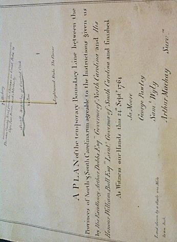
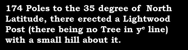
2 How did North Carolina get its shape? North Carolina/South Carolina boundary King George II issued a decree in 1735 that: The line shall begin at the sea, thirty miles from the west side of the mouth of the Cape Fear River. From thence, it shall run on a northwest course to the thirty-fifth parallel of north latitude [35 North latitude], and from thence due west to the South Seas.

3 How did North Carolina get its shape? The line shall: 1. Begin at the sea, 30 miles from the west side of the mouth of the Cape Fear River 2. From thence, it shall run on a northwest course to 35⁰ N latitude 3. From thence due west to the South Seas
4 Chapter 141 State Boundaries Governor to cause boundaries to be established and protected. The Governor of North Carolina is hereby authorized to appoint two competent commissioners and a surveyor and a sufficient number of chainbearers, on the part of the State of North Carolina, to act with the commissioners or surveyors appointed or to be appointed by any of the contiguous states of Virginia, Tennessee, South Carolina, and Georgia, to return and remark, by some permanent monuments at convenient intervals, not greater than five miles, the boundary lines between this State and any of the said states. The Governor is also authorized, whenever in his judgment it shall be deemed necessary to protect or establish the boundary lines between this State and any other state, to institute and prosecute in the name of the State of North Carolina any and all such actions, suits, or proceedings at law or in equity, and to direct the Attorney General or such other person as he may designate to conduct and prosecute such actions, suits, or proceedings. (1881, c. 347, s. 1; Code, s. 2289; 1889, c. 475, s. 1; Rev., s. 5315; 1909, c. 51, s. 1; C.S., s ) Payment of expenses of establishing boundaries. When the line has been rerun and remarked as above provided between this State and any of the contiguous states, or such portion of said lines as shall be mutually agreed by the commissioners, the Governor is authorized to issue his warrant upon the State Treasurer for such portion of the expenses as shall fall to the share of this State. (1881, c. 347, s. 2; Code, s. 2290; 1889, c. 475, s. 2; Rev., s. 5316; C.S., s ) Appointment of arbitrators. If any disagreement shall arise between the commissioners, the Governor of this State is hereby authorized to appoint arbitrators to act with similar officers to be appointed by the other states in the settlement of the exact boundary. (1881, c. 347, s. 3; Code, s. 2291; 1889, c. 475, s. 3; Rev., s. 5317; C.S., s ) Disagreement of arbitrators reported to General Assembly. In case of any serious disagreement and inability on the part of the said arbitrators to agree upon said boundary, such fact shall be reported by the Governor to the next General Assembly for their action. (1881, c. 347, s. 4; Code, s. 2292; 1889, c. 475, s. 4; Rev., s. 5318; C.S., s ) Approval of survey. When the commissioners shall have completed the survey, or so much as shall be necessary, they shall report the same to the Governor, who shall lay the same before the Council of State; and when the Governor and the Council of State shall have approved the same the Governor shall issue his proclamation, declaring said lines to be the true boundary line or lines, and the same shall be the true boundary line or lines between this and the states above referred to. (1881, c. 347, s. 5; Code, s. 2293; 1889, c. 475, s. 5; Rev., s. 5319; C.S., s ) Eastern boundary of State; jurisdiction over territory within littoral waters and lands under same. (a) The Constitution of the State of North Carolina, adopted in 1868, having provided in Article I, Sec. 34, that the "limits and boundaries of the State shall be and remain as they now are," and the eastern limit and boundary of the State of North Carolina on the Atlantic seaboard having always been, since the Treaty of Peace with Great Britain in 1783 and the Declaration of Independence of July 4, 1776, one marine league eastward from the Atlantic seashore, measured from the extreme low-water mark, the eastern boundary of the State of North Carolina is hereby declared to be fixed as it has always been at one marine league eastward from the seashore of the Atlantic Ocean bordering the State of North Carolina, measured from the extreme low-water mark of the Atlantic Ocean seashore aforesaid. (b) The State of North Carolina shall continue as it always has to exercise jurisdiction over the territory within the littoral waters and ownership of the lands under the same within the boundaries of the State, subject only to the jurisdiction of the federal government over navigation within such territorial waters. (c) The Governor and the Attorney General are hereby directed to take all such action as may be found appropriate to defend the jurisdiction of the State over its littoral waters and the ownership of the lands beneath the same. (1947, c. 1031, ss. 1-3; 1969, c. 541, s. 1.)

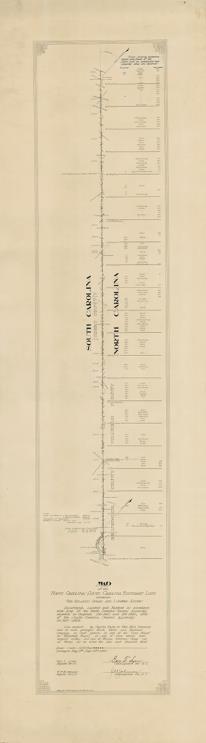
5 Survey

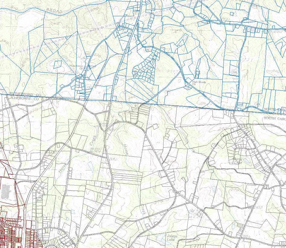
6 Survey Dillon County


7 Survey Dillon County


8 THE LITTLE BOUNDARY HOUSE

9
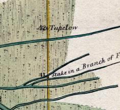
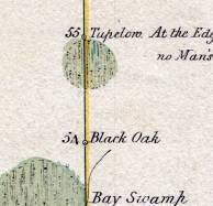
10 1772 Survey

11 1905 SURVEY TO RE-ESTABLISH THE SC NC BOUNDARY BETWEEN MARLBORO COUNTY, SC AND RICHMOND AND SCOTLAND COUNTIES, NC


12 NC-SC Boundary 1905 Survey


13 NC-SC Boundary 1905 Survey

14


15 GOAT ISLAND MARSH BETWEEN GOAT ISLAND AND MAINLAND BOUNDARY MON 1 GRANITE NC SC SOUTHEASTERNMOST 1928 GRANITE MONUMENT BOUNDARY MON 2 GRANITE NC SC


16 GRANITE MONUMENTS SET AT TWO-MILE INTERVALS 6 MILE STONE 26 MILE STONE
17 How did North Carolina get its shape? The line shall: 1. Begin at the sea, 30 miles from the west side of the mouth of the Cape Fear River 2. From thence, it shall run on a northwest course to 35⁰ N latitude 3. From thence due west to the South Seas

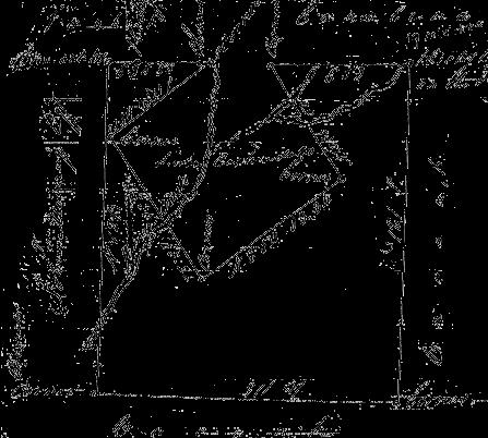
18 Phil Cort at Ellicott's Rock The Boundaries Sid Miller at Commissioner's Rock

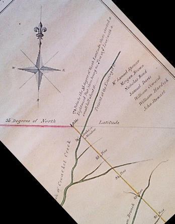
19 How did North Carolina get its shape? North Carolina/South Carolina boundary 1815 survey Proceeded from the terminus of the 1772 survey Along a ridgeline separating two watersheds West-southwest to Commissioners Rock, which is a rock outcrop on the east bank of the Chattooga River that the NC & SC boundary commissioners had inscribed thinking that it was on the 35 th parallel Although Commissioners Rock is 493 ft north of the 35th parallel, it defines a tri-state/quad-county corner: North Carolina: Henderson and Transylvania counties South Carolina: Oconee County Georgia: Rabun County


20 Block House Stone

21 The Boundaries Alex at the NC/SC stones

22 The Boundaries SC rock

23 The Boundaries NC rock

24 1772 Survey


25 Concurrent Boundary Surveys Tree Mile Tree 19 Mile Tree

26 James Parsons 19 Mile Tree

27 Linking Historical and Current
28 Joseph Warren 44 Mile Tree

29 Linking Historical and Current
30
31 How did North Carolina get its shape? What tools did we use to reestablish the NC- SC boundary? Historical documents GIS and CAD mapping tools Global Navigation Satellite Systems GPS GLONASS Total station
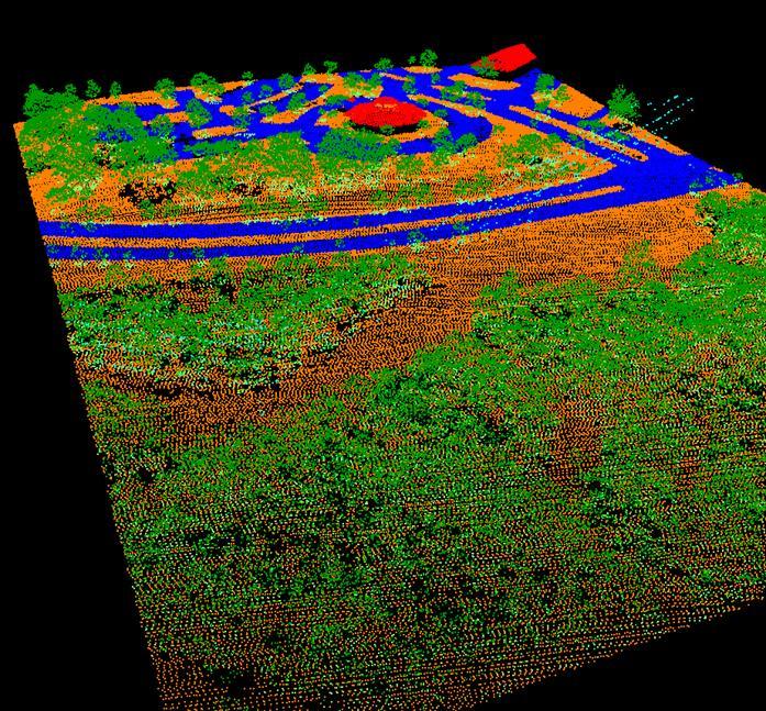
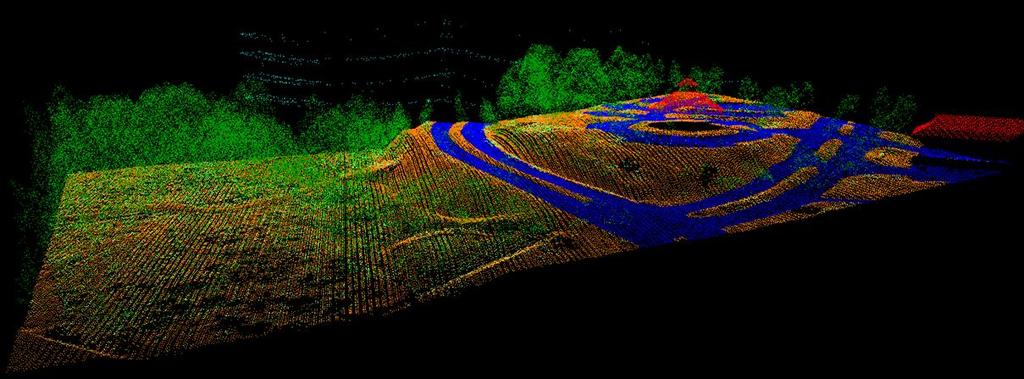
32 Non-Differential GPS (Autonomous or Stand-alone) d 23 X 23 Y 23 Z 23 X 19 Y 19 Z 19 d 19 d 14 X 14 Y 14 Z 14 X 21 Y 21 Z 21 d 21 Rover unit at an unknown location Measured: X Y Z

33 Real-Time Differential GPS X 23 Y 23 Z 23 X 19 Y 19 Z 19 X 14 Y 14 Z 14 X 21 Y 21 Z 21 Rover unit Base station Base radio broadcasting correction signals Measured: X Y Z Delta: X Y Z True: X Y Z Corrections applied during the survey True: X Y Z Measured: X Y Z Delta: X Y Z
 receiver, antenna (with a surveyed")
* UNCC (NC49)* 1 decommissioned Clinton (NCCL * = Not accepted")
34 NC CORS Network Continuously Operating Reference Station (CORS) A permanent and continuously recording Global Navigation Satellite System (GNSS) receiver, antenna (with a surveyed reference position), & support equipment NC CORS Network Composed of 91 CORS 2 new CORS have been installed Bethel (NCBT)* UNCC (NC49)* 1 decommissioned Clinton (NCCL * = Not accepted by NGS


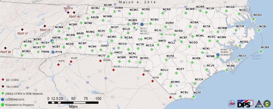
35 NC CORS Network

36 Data flow in the RTN CORS CORS Raw Data CMR+ / RTCM RTN Network Servers Router *Virtual Ref. Station NMEA Position CORS CORS


37 NC CORS Supports Surveying & Mapping

38 Total Station

39 LIDAR laser sensor
40

41
42


43 Mobile Scanning Applications NC Railroad Company s Hy-Rail vehicle Mobile scanners and positioning equipment installed on vehicle NC CORS provides real-time positioning info to support the Hy-Rail vehicle s GNSS equipment
44

45
46 South of the Border 1 3/4 PIPE #
47 Questions? Gary W. Thompson, PLS Office: Direct: Mailing address: Gary W. Thompson, PLS NC Geodetic Survey 4298 Mail Service Center Raleigh, NC Building (shipping) address: Gary W. Thompson, PLS NC Geodetic Survey Bowers Building NC National Guard complex 4105 Reedy Creek Rd Raleigh, NC 27607
TREATY BETWEEN THE UNITED STATES OF AMERICA
 TREATY BETWEEN THE UNITED STATES OF AMERICA AND THE UNITED KINGDOM CONCERNING THE BOUNDARY BETWEEN THE UNITED STATES AND THE DOMINION OF CANADA FROM THE ATLANTIC OCEAN TO THE PACIFIC OCEAN Signed at Washington,
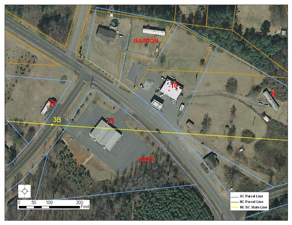
SOUTH CAROLINA BOUNDARY COMMISSION REPORT for FY South Carolina North Carolina Boundary
 SOUTH CAROLINA BOUNDARY COMMISSION REPORT for FY 2013-14 South Carolina North Carolina Boundary When issues arose regarding the state boundary between York County, SC and Gaston County, NC in the early
No. 1 THE ROYAL PROCLAMATION October 7, 1763
 The Royal Proclamation. October 7, 1763. No. 1 THE ROYAL PROCLAMATION October 7, 1763 BY THE KING. A PROCLAMATION GEORGE R. Whereas We have taken into Our Royal Consideration the extensive and valuable
1. What did the Articles of Capitulation allow the French to do in Quebec. Do you think they changed the average French Canadiens life greatly?
 Name/Date: Social Studies 9 Unit 4 Struggle for Control of a Continent 4D Aftermath of the Seven Years War References: Cranny, M. (1998) Crossroads: A Meeting of Nations, Ch. 10 p. 294-299 Topographic
Minutes of the Meeting
 The office of the Secretary of State for The United States of America Office hours: 9 A.M- 8:30 P.M. Monday Friday Phone: 1-951-389-0313 Email: secretaryofstatefortusa@generalpost.org Letterhead for International
The Paris Peace Treaty of 1783
 The Paris Peace Treaty of 1783 OVERVIEW In this treaty, Britain recognized the United States of America as a new nation with the Missippippi River as its western border. Britain also returned Florida to
NC General Statutes - Chapter 104 Article 1 1
 Chapter 104. United States Lands. Article 1. Authority for Acquisition. 104-1. Acquisition of lands for specified purposes authorized; concurrent jurisdiction reserved. The United States is authorized,
CHAPTER Council Substitute for House Bill No. 1315
 CHAPTER 2007-222 Council Substitute for House Bill No. 1315 An act relating to local government boundaries; amending ss. 7.06 and 7.50, F.S.; extending and enlarging the boundaries of Broward County to
THE PARIS PEACE TREATY (PEACE TREATY of 1783): In the name of the most holy and undivided Trinity.
: In the name of the most holy and undivided Trinity.") THE PARIS PEACE TREATY (PEACE TREATY of 1783): In the name of the most holy and undivided Trinity. It having pleased the Divine Providence to dispose the hearts of the most serene and most potent Prince
THE PARIS PEACE TREATY (PEACE TREATY of 1783): In the name of the most holy and undivided Trinity. It having pleased the Divine Providence to dispose the hearts of the most serene and most potent Prince
An Act to Regulate Trade and Intercourse with the Indian Tribes, and to Preserve Peace on the Frontiers
 An Act to Regulate Trade and Intercourse with the Indian Tribes, and to Preserve Peace on the Frontiers SECTION 1. Be it enacted lay the Senate and House of Representatives of the United States of America
Revolution and the Early Republic
 Date REVIEW CHAPTER 2 Form B CHAPTER TEST Revolution and the Early Republic Part 1: Main Ideas If the statement is true, write true on the line. If it is false, change the underlined word or words to make
Treaty of Ghent, Treaty of Peace and Amity between His Britannic Majesty and the United States of America.
 Treaty of Ghent, 1814 Treaty of Peace and Amity between His Britannic Majesty and the United States of America. His Britannic Majesty and the United States of America desirous of terminating the war which
CHARTER* ARTICLE I. HISTORICAL BACKGROUND
 CHARTER* Art. I. Historical Background Div. 1. Private Laws Of 1883, Chapter 103 Div. 2. Private Laws Of 1885, Chapter 5 Div. 3. Private Laws Of 1905, Chapter 415 Div. 4. Private Laws, Extra Session 1920,
PLEASE NOTE Legislative Counsel Office not Table of Public Acts
 c t LAND SURVEY ACT PLEASE NOTE This document, prepared by the Legislative Counsel Office, is an office consolidation of this Act, current to December 2, 2015. It is intended for information and reference
BEFORE THE BOARD OF COUNTY COMMISSIONERS MARTIN COUNTY, FLORIDA
 BEFORE THE BOARD OF COUNTY COMMISSIONERS MARTIN COUNTY, FLORIDA ORDINANCE NO. 521 AN ORDINANCE AMENDING PORTIONS OF CHAPTER 13, FINANCE AND TAXATION, ARTICLE III, SPECIAL TAXING DISTRICTS; AND PORTIONS
TREATY BETWEEN THE UNITED STATES AND GREAT BRITAIN RELATING TO BOUNDARY WATERS, AND QUESTIONS ARISING BETWEEN THE UNITED STATES AND CANADA
 TREATY BETWEEN THE UNITED STATES AND GREAT BRITAIN RELATING TO BOUNDARY WATERS, AND QUESTIONS ARISING BETWEEN THE UNITED STATES AND CANADA The United States of America and His Majesty the King of the United
page 1 Delimitation Treaties Infobase accessed on 14/03/2002 DOALOS/OLA - UNITED NATIONS
 page 1 Delimitation Treaties Infobase accessed on 14/03/2002 Convention between the Government of the French Republic and the Government of the Spanish State on the Delimitation of the Continental Shelves
CHAPTER MCDLVII. ANACT TO ESTABLISH AND CONFIRM THE BOUNDARY LINE BETWHEN THIS STATE AND THF.~STATE OF NEW YORK.
 378 The ìstatutes at Large of Pei~nsylvania. [1789 in the said county of Muffin to attend at the house of Thomas Wilson for the purpose of holding their annual elections: [Section III.] (Section IV, P.
IOWA-NEBRASKA BOUNDARY COMPACT
 (1) Ratification by Nebraska Legislature IOWA-NEBRASKA BOUNDARY COMPACT AN ACT to establish the boundary line between Iowa and Nebraska by agreement; to cede to Iowa and to relinquish jurisdiction over
REPORTS OF INTERNATIONAL ARBITRAL AWARDS RECUEIL DES SENTENCES ARBITRALES
 REPORTS OF INTERNATIONAL ARBITRAL AWARDS RECUEIL DES SENTENCES ARBITRALES Declaration under Article V of the Treaty of 1794, between the United States and Great Britain, respecting the true River Saint
RESOLUTION NO. WHEREAS, both cities have an ETJ which extends three and one-half (3-1/2) miles beyond the corporate limits; and
 miles beyond the corporate limits; and") RESOLUTION NO. A RESOLUTION OF THE CITY OF BRYAN, TEXAS, AUTHORIZING THE MAYOR TO EXECUTE AN INTERLOCAL AGREEMENT WITH THE CITY OF COLLEGE STATION, TEXAS, IN ACCORDANCE WITH THE INTERLOCAL COOPERATION
RESOLUTION NO. A RESOLUTION OF THE CITY OF BRYAN, TEXAS, AUTHORIZING THE MAYOR TO EXECUTE AN INTERLOCAL AGREEMENT WITH THE CITY OF COLLEGE STATION, TEXAS, IN ACCORDANCE WITH THE INTERLOCAL COOPERATION
Events Leading to the War of 1812
 Events Leading to the War of 1812 The United States fought the Revolutionary War with Great Britain to gain independence and become a new nation. The Revolutionary War started in 1775. Eight years later,
GNSS Performance Monitoring IGMA-IGS Joint Trial Project
 International Global Navigation Satellite Systems Service www.igs.org GNSS Performance Monitoring IGMA-IGS Joint Trial Project Call for Participation Document prepared by: International Committee on GNSS
SECTION SIXTEEN GENERAL RULES AND REGULATIONS - VESSELS ANCHORAGE GROUNDS AND FAIRWAYS
 First Revised Page... 143 Cancels Original Page... 143 SECTION SIXTEEN GENERAL RULES AND REGULATIONS - VESSELS ANCHORAGE GROUNDS AND FAIRWAYS The anchorage grounds for vessels in the navigable waters of
Marine Boundaries and Jurisdiction Act, , 25 February 1978 PART I PRELIMINARY
 Page 1 Marine Boundaries and Jurisdiction Act, 1978-3, 25 February 1978 An Act to provide for the establishment of Marine Boundaries and Jurisdiction. Commencement (By Proclamation) ENACTED by the Parliament
The Webster- Ashburton Treaty 1 Signed in Washington City - August 9,1842
 The Webster- Ashburton Treaty 1 Signed in Washington City - August 9,1842 A Treaty to settle and define the Boundaries between the Territories of the United States and the possessions of Her Britannic
U.S. International Borders: Brief Facts
 Order Code RS21729 Updated February 1, 2007 U.S. International Borders: Brief Facts Janice Cheryl Beaver Information Research Specialist Knowledge Services Group Summary This report 1 provides information
2013 No CONTINENTAL SHELF. The Continental Shelf (Designation of Areas) Order 2013
 Order 2013") S T A T U T O R Y I N S T R U M E N T S 2013 No. 3162 CONTINENTAL SHELF The Continental Shelf (Designation of Areas) Order 2013 Made - - - - 11th December 2013 Coming into force - - 31st March 2014 At
S T A T U T O R Y I N S T R U M E N T S 2013 No. 3162 CONTINENTAL SHELF The Continental Shelf (Designation of Areas) Order 2013 Made - - - - 11th December 2013 Coming into force - - 31st March 2014 At
SOUTH PACIFIC NUCLEAR-FREE ZONE (TREATY OF RAROTONGA)
") SOUTH PACIFIC NUCLEAR-FREE ZONE (TREATY OF RAROTONGA) Signed at Rarotonga: 6 August 1985. Entered into force: 11 December 1986. Depositary: Director of the South Pacific Bureau For Economic Cooperation.
SOUTH PACIFIC NUCLEAR-FREE ZONE (TREATY OF RAROTONGA) Signed at Rarotonga: 6 August 1985. Entered into force: 11 December 1986. Depositary: Director of the South Pacific Bureau For Economic Cooperation.
TITLE 33. MARINE ZONES AND PROTECTION OF MAMMALS
 TITLE 33. MARINE ZONES AND PROTECTION OF MAMMALS CHAPTER 1. MARINE ZONES ARRANGEMENT OF SECTIONS Section PART I - PRELIMINARY 109. The Contiguous zone. 101. Short Title. 110. Legal Character of Marine
Treaty concerning the Archipelago of Spitsbergen, and Protocol (Paris, 9 February 1920) TREATY CONCERNING THE ARCHIPELAGO OF SPITSBERGEN
 TREATY CONCERNING THE ARCHIPELAGO OF SPITSBERGEN") Treaty concerning the Archipelago of Spitsbergen, and Protocol (Paris, 9 February 1920) TREATY CONCERNING THE ARCHIPELAGO OF SPITSBERGEN The President of the United States of America; His Majesty the King
Treaty concerning the Archipelago of Spitsbergen, and Protocol (Paris, 9 February 1920) TREATY CONCERNING THE ARCHIPELAGO OF SPITSBERGEN The President of the United States of America; His Majesty the King
July 5, 2011 RESOLUTION NO : APPROVAL OF COUNCIL PROCEEDINGS
 COUNCIL PROCEEDINGS The City Council of Thief River Falls, Minnesota, met in regular session at 5:00 p.m. on in the Council Chambers of City Hall. The following Councilmembers were present: Erickson, Haj,
International Convention for the Prevention of Pollution of the Sea by Oil, 1954.
 Downloaded on July 21, 2018 International Convention for the Prevention of Pollution of the Sea by Oil, 1954. Region United Nations (UN) Subject Maritime Sub Subject Type Conventions Reference Number Place
Study Island. Generation Date: 04/03/2014 Generated By: Cheryl Shelton Title: Grade 8 Government/ Economics
 Study Island Copyright 2014 Edmentum - All rights reserved. Generation Date: 04/03/2014 Generated By: Cheryl Shelton Title: Grade 8 Government/ Economics 1. A committee chairperson may call for hearings,
CHAPTER House Bill No. 1787
 CHAPTER 2000-478 House Bill No. 1787 An act relating to the St. Augustine Port, Waterway and Beach District; codifying the district s charter; providing for the levy of ad valorem taxes in a manner consistent
STATE OF SOUTH CAROLINA ) ) IN THE COURT OF COMMON PLEAS COUNTY OF BEAUFORT ) ) ) ) ) ) ) ) ) ) ) )
 ) IN THE COURT OF COMMON PLEAS COUNTY OF BEAUFORT ) ) ) ) ) ) ) ) ) ) ) )") STATE OF SOUTH CAROLINA IN THE COURT OF COMMON PLEAS COUNTY OF BEAUFORT Harbor Island Owners Association, vs. State of South Carolina, Plaintiff, Defendant. TO: THE DEFENDANT ABOVE-NAMED: Case No. 18-CP-22-
STATE OF SOUTH CAROLINA IN THE COURT OF COMMON PLEAS COUNTY OF BEAUFORT Harbor Island Owners Association, vs. State of South Carolina, Plaintiff, Defendant. TO: THE DEFENDANT ABOVE-NAMED: Case No. 18-CP-22-
Legislation Defining Louisiana's Coastal Boundaries
 Louisiana Law Review Volume 15 Number 1 Survey of 1954 Louisiana Legislation December 1954 Legislation Defining Louisiana's Coastal Boundaries Victor A. Sachse Repository Citation Victor A. Sachse, Legislation
The Boundaries of the State of Louisiana
 Louisiana Law Review Volume 42 Number 3 Student Symposium: Sentence Review in Louisiana Spring 1982 The Boundaries of the State of Louisiana Oliver P. Stockwell Repository Citation Oliver P. Stockwell,
CHARTER OF THE TOWN OF GATES, TENNESSEE 1 CHAPTER NO. 286 HOUSE BILL NO (By Haynes of Lauderdale)
") C-1 CHARTER OF THE TOWN OF GATES, TENNESSEE 1 CHAPTER NO. 286 HOUSE BILL NO. 607 (By Haynes of Lauderdale) AN ACT incorporating the Town of Gates, Lauderdale County, Tennessee; to give it a corporate title;
C-1 CHARTER OF THE TOWN OF GATES, TENNESSEE 1 CHAPTER NO. 286 HOUSE BILL NO. 607 (By Haynes of Lauderdale) AN ACT incorporating the Town of Gates, Lauderdale County, Tennessee; to give it a corporate title;
CHAPTER Committee Substitute for House Bill No. 1363
 CHAPTER 2017-221 Committee Substitute for House Bill No. 1363 An act relating to Santa Rosa County; creating the Pace Fire Rescue District, an independent special district; creating a district charter;
PCA PRESS RELEASE ARBITRATION BETWEEN THE REPUBLIC OF CROATIA AND THE REPUBLIC OF SLOVENIA
 PCA PRESS RELEASE ARBITRATION BETWEEN THE REPUBLIC OF CROATIA AND THE REPUBLIC OF SLOVENIA THE HAGUE, 29 June 2017 Tribunal Determines Land and Maritime Boundaries in Final Award In the arbitration concerning
1 LEGISLATIVE ANALYSIS FORM
 COUNTY OF SANTA BARBARA 1 LEGISLATIVE ANALYSIS FORM This form is required for the Legislative Program Committee to consider taking an advocacy position on an issue or legislative item BILL NUMBER: AUTHOR:
NORTH CAROLINA GENERAL ASSEMBLY 1959 SESSION CHAPTER 108 HOUSE BILL 293
 NORTH CAROLINA GENERAL ASSEMBLY 1959 SESSION CHAPTER 108 HOUSE BILL 293 AN ACT TO PROVIDE FOR ELECTIONS IN THE TOWNS OF LEAKSVILLE AND SPRAY ON THE CONSOLIDATION OF SAID TOWNS AND SUBJECT TO SAID ELECTIONS
Federal Act relating to the Sea, 8 January 1986
 Page 1 Federal Act relating to the Sea, 8 January 1986 The Congress of the United Mexican States decrees: TITLE I General Provisions CHAPTER I Scope of application of the Act Article 1 This Act establishes
No Be it enacted by the General Assembly of the State of South Carolina:
 No. 498 An Act To Create The James Island Public Service District In Charleston County And To Provide That Bonds Of Such District May Be Issued In An Amount Not To Exceed One Hundred Thousand Dollars And
Proclamation of Introduction
 1 Introduction At the end of the Seven Years War in 1763, France surrendered Canada and much of the Ohio and Mississippi valleys two-thirds of eastern North America to England. The Proclamation of 1763
NC General Statutes - Chapter 40A Article 1 1
 Chapter 40A. Eminent Domain. Article 1. General. 40A-1. Exclusive provisions. (a) Notwithstanding the provisions of any local act, it is the intent of the General Assembly that, effective August 15, 2006,
CONSTITUTION OF THE CHOCTAW NATION. November 10, 1842 PREAMBLE
 CONSTITUTION OF THE CHOCTAW NATION November 10, 1842 PREAMBLE We, the people of the Choctaw Nation, having a right to establish our own form of Government, not inconsistent with the Constitution, Treaties
CONSTITUTION OF THE CHOCTAW NATION November 10, 1842 PREAMBLE We, the people of the Choctaw Nation, having a right to establish our own form of
 CONSTITUTION OF THE CHOCTAW NATION November 10, 1842 PREAMBLE We, the people of the Choctaw Nation, having a right to establish our own form of Government, not inconsistent with the Constitution, Treaties
United States. The governor shall reside in said Territory, shall be the commander-in-chief of the militia thereof, shall perform the duties and
 Organic Act of 1853 Be it enacted by the Senate and House of Representatives of the United States of America in Congress assembled, That from and after the passage of this act, all that portion of Oregon
PETROLEUM CHAPTER 219 PETROLEUM
 [CH.219 1 LIST OF AUTHORISED PAGES 1-2 LRO 1/2008 3-6 Original 7-8 LRO 1/2008 9-17 Original CHAPTER 219 ARRANGEMENT OF SECTIONS PART I PRELIMINARY SECTION 1. Short title. 2. Interpretation. 3. Property
KENTUCKY TENNESSEE BOUNDARY
 KENTUCKY TENNESSEE BOUNDARY The foundation for what was to become the boundary between Kentucky and Tennessee was laid on June 30, 1677 when King Charles II of England granted a charter to Clarendon &
CHAPTER House Bill No. 1183
 CHAPTER 2001-338 House Bill No. 1183 An act relating to the Englewood Area Fire Control District in Sarasota and Charlotte Counties; codifying, reenacting, amending, and repealing special laws relating
FIFTH REGULAR SESSION, 2016 C.B. NO A BILL FOR AN ACT
 NINETEENTH CONGRESS OF THE FEDERATED STATES OF MICRONESIA FIFTH REGULAR SESSION, C.B. NO. - A BILL FOR AN ACT To amend sections,,,,, and of title of the Code of the Federated States of Micronesia (Annotated),
NC General Statutes - Chapter 160A Article 23 1
 Article 23. Municipal Service Districts. 160A-535. Title; effective date. This Article may be cited as "The Municipal Service District Act of 1973," and is enacted pursuant to Article V, Sec. 2(4) of the
The Confederation Era
 1 The Confederation Era MAIN IDEA The Articles of Confederation were too weak to govern the nation after the war ended. WHY IT MATTERS NOW The weakness of the Articles of Confederation led to the writing
PUBLIC LAW NOV. 16, An Act SHORT TITLE FINDINGS
 PUBLIC LAW 101-605 NOV. 16, 1990 Public Law 101-605 101st Congress 104 STAT. 3089 An Act To establish the Florida Keys National Marine Sanctuary, and for othei purposes. Be it enacted by the Senate and
Number 18 of 1999 SEA POLLUTION (AMENDMENT) ACT, 1999
 ACT, 1999") Page 1 Number 18 of 1999 SEA POLLUTION (AMENDMENT) ACT, 1999 ARRANGEMENT OF SECTIONS Section 1. Interpretation. 2. Preparation and submission of plans to Minister. 3. Oil pollution emergency plans. 4.
Page 1 Number 18 of 1999 SEA POLLUTION (AMENDMENT) ACT, 1999 ARRANGEMENT OF SECTIONS Section 1. Interpretation. 2. Preparation and submission of plans to Minister. 3. Oil pollution emergency plans. 4.
CHAPTER House Bill No. 1205
 CHAPTER 2006-343 House Bill No. 1205 An act relating to Indian River Farms Water Control District, Indian River County; codifying, amending, reenacting, and repealing special acts relating to the district;
CHARTER FOR THE TOWN OF LIBERTY, TENNESSEE 1 CHAPTER NO. 796 HOUSE BILL NO (By Foutch)
") C-1 CHARTER FOR THE TOWN OF LIBERTY, TENNESSEE 1 CHAPTER NO. 796 HOUSE BILL NO. 1428 (By Foutch) AN ACT to incorporate the Town of Liberty, in the County of Dekalb, State of Tennessee; to provide for the
C-1 CHARTER FOR THE TOWN OF LIBERTY, TENNESSEE 1 CHAPTER NO. 796 HOUSE BILL NO. 1428 (By Foutch) AN ACT to incorporate the Town of Liberty, in the County of Dekalb, State of Tennessee; to provide for the
Article 1. Article 2. Article 3. Article 4
 page 1 Delimitation Treaties Infobase accessed on 18/03/2002 Agreement between the Government of the United Kingdom of Great Britain and Northern Ireland and the Government of the United States of America
CONVENTION AND PROTOCOL
 15 GEORGE V. SESSIONAL PAPER No. 98 CONVENTION AND PROTOCOL Between HIS BRITANNIC MAJESTY IN RESPECT OF THE DOMINION OF CANADA AND THE UNITED STATES For Regulating the Level of the Lake of the Woods, and
Kansas-Nebraska Act (1854) An Act to Organize the Territories of Nebraska and Kansas.
 An Act to Organize the Territories of Nebraska and Kansas.") Kansas-Nebraska Act (1854) An Act to Organize the Territories of Nebraska and Kansas. Be it enacted by the Senate and House of Representatives of the United States of America in Congress assembled, That
Kansas-Nebraska Act (1854) An Act to Organize the Territories of Nebraska and Kansas. Be it enacted by the Senate and House of Representatives of the United States of America in Congress assembled, That
ATLANTIC STATES MARINE FISHERIES COMPACT
 The Governor of this State shall execute a Compact on behalf of this State with any 1 or more of the States of Maine, New Hampshire, Massachusetts, Connecticut, Rhode Island, New York, New Jersey, Maryland,
IC 8-3 ARTICLE 3. RAILROADS GENERALLY
 IC 8-3 ARTICLE 3. RAILROADS GENERALLY IC 8-3-1 Chapter 1. Railroad Regulation)Department of Transportation IC 8-3-1-1 Financial and business operations report Sec. 1. (a) As used in this chapter, "department"
UNITED STATES DISTRICT COURT EASTERN DISTRICT OF WASHINGTON. Plaintiff,
 Case :-cv-0 ECF No. filed /0/ PageID. Page of Ethan Jones, WSBA No. Yakama Nation Office of Legal Counsel (0) - ethan@yakamanation-olc.org Joe Sexton, WSBA No. 0 Galanda Broadman PLLC 0 th Ave NE, Suite
Circuit Court, D. California. September 17, 1883.
 10 PACIFIC COAST STEAM-SHIP CO. V. BOARD OF RAILROAD COM'RS. Circuit Court, D. California. September 17, 1883. INTERSTATE COMMERCE POWER OF THE STATE TO REGULATE. The state board of railroad commissioners
LOOKING GLASS RIVER INTERCOUNTY DRAIN
 LOOKING GLASS RIVER INTERCOUNTY DRAIN DRAINAGE BOARD MEETING Wednesday, August 16, 2017 Clinton County Courthouse St. Johns, Michigan PRESENT: ABSENT: Michael Gregg, Michigan Department of Agriculture
Jurisdiction of the Interstate Commerce Commission--Abandonment of Road Entirely Within a State
 St. John's Law Review Volume 6, May 1932, Number 2 Article 9 Jurisdiction of the Interstate Commerce Commission--Abandonment of Road Entirely Within a State Sidney Brandes Follow this and additional works
CHAPTER House Bill No. 1853
 CHAPTER 2000-489 House Bill No. 1853 An act relating to Palm Beach County; amending chapter 87-450, Laws of Florida, as amended, relating to the Palm Beach County Health Care Act; changing name of the
NDB LIST AWARDS INTRODUCTION:
 NDB LIST AWARDS INTRODUCTION: The NDB List Awards Program recognizes the achievements of radio hobbyists who DX non-directional radio beacons in the LF/MF frequency range (190 to 1800 khz). These certificates
Submit the deed or legal instrument identifying the applicant s interest in the property.
 ZONING PERMIT for TELECOMMUNICATIONS ANTENNA TOWER (ZPTT) SUBMITTAL CHECKLIST DEPARTMENT OF PLANNING SERVICES * 1555 N. 17 TH AVENUE * GREELEY, CO 80631 www.weldgov.com * 970-400-6100 * FAX 970-304-6498
CHAPTER 2. MARINE ZONES ARRANGEMENT OF SECTIONS
 ARRANGEMENT OF SECTIONS Section PART I- PRELIMINARY I. Short title. 2. Interpretation. 3. References to rules of international law. 4. Application of this Act. PART II THE S. Internal waters. 6. Archipelagic
Completion Surveys and Subdivision of Sections
 Completion Surveys and Subdivision of Sections 1. Introduction and basic concepts regarding completion surveys 2. Case 1 Resolving basic lotting of completion surveys 3. Case 2 Resolving more advanced
172 THIRTY-SIXTH CONGRESS. SESS. II. CH
 SOURCE: The Statutes at Large, Treaties and Proclamations of the United States of America from December 5, 1859 to March 3, 1863. Ed. By George P. Sanger. Vol. 12, pp.172-177. Boston: Little, Brown and
CHAPTER House Bill No. 1603
 CHAPTER 2000-436 House Bill No. 1603 An act relating to the Indian Rocks Fire District, Pinellas County; providing for codification of special laws regarding independent special fire control districts
NC General Statutes - Chapter 18B Article 6 1
 Article 6. Elections. 18B-600. Places eligible to hold alcoholic beverage elections. (a) Kinds of Elections. The following kinds of alcoholic beverage elections shall be permitted: (1) Malt beverage; (2)
We re Free Let s Grow!
 Atlantic Ocean Find Those States! The United States started out with just thirteen states. Use the list below to correctly identify each one on the map. Watch out: Things were a little different back then!
Washington s Presidency
 !CHAPTER 9 SECTION 1 REVIEW Washington s Presidency Specific Objective Learn that George Washington and his advisers faced many challenges during his Presidency. Directions: Read the summary below to answer
BE it enacted by the Kings Most Excellent Majesty,
 RIVER MURRAY WATERS (AMENDMENT) ACT. Act No. 31, 1934. An Act to ratify and approve an Agreement for the further variation of a certain Agreement entered into between the Prime Minister of the Commonwealth
The Sabine River Boundary between Texas and Louisiana
 SMU Law Review Volume 29 1975 The Sabine River Boundary between Texas and Louisiana Price Sr. Daniel Follow this and additional works at: https://scholar.smu.edu/smulr Recommended Citation Price Sr. Daniel,
South China Sea- An Insight
 South China Sea- An Insight Historical Background China laid claim to the South China Sea (SCS) back in 1947. It demarcated its claims with a U-shaped line made up of eleven dashes on a map, covering most
IN THE STATE OIL AND GAS BOARD OF MISSISSIPPI DOCKET NO
 FILED FOR RECORD JUN 211984 IN THE STATE OIL AND GAS BOARD OF MISSISSIPPI STATE OIL AND GAS BOARt A. Richard Henderson. Supervisor DOCKET NO. 170-34-591 ORDER NO. IN RE: PETITION OF ADCO PRODUCING COMPANY,
S. ll. To provide for the admission of the State of New Columbia into the Union. IN THE SENATE OF THE UNITED STATES
 TH CONGRESS D SESSION S. ll To provide for the admission of the State of New Columbia into the Union. IN THE SENATE OF THE UNITED STATES llllllllll Mr. LIEBERMAN (for himself, Mr. DURBIN, Mrs. MURRAY,
Power Point Maps & Boundary Details
 Power Point Maps & Boundary Details (to supplement the History Channel video) prepared and compiled by Max Beauregard based upon the book by Mark Stein Original maps courtesy of Perry Castaneda Library,
Mar. 2, Stat., 888.
 Mar. 2, 1889. 25 Stat., 888. An act to divide a portion of the reservation of the Sioux Nation of Indians in Dakota into separate reservations and to secure the relinquishment of the Indian title to the
SYLLABUS BY THE COURT
 1 SANTE FE GOLD & COPPER MINING CO. V. ATCHISON, T. & S. F. RY., 1915-NMSC-016, 21 N.M. 496, 155 P. 1093 (S. Ct. 1915) SANTA FE GOLD & COPPER MINING COMPANY vs. ATCHISON, T. & S. F. RY. CO. No. 1793 SUPREME
BEULAVILLE TOWN CHARTER. INCORPORATION AND CORPORATION POWERS Incorporation and General Powers
 BEULAVILLE TOWN CHARTER TITLE 1 ARTICLE I Section 1.1 INCORPORATION AND CORPORATION POWERS Incorporation and General Powers The Town of Beulaville shall continue to be a body politic and corporate under
c t EXPROPRIATION ACT
 c t EXPROPRIATION ACT PLEASE NOTE This document, prepared by the Legislative Counsel Office, is an office consolidation of this Act, current to December 2, 2015. It is intended for information and reference
==-f=-pl u- DEPARTMENT OF MARINE ADMINISTRATION MINISTRY OF TRANSPORT AND COMMUNICATIONS
 MINISTRY OF TRANSPORT AND COMMUNICATIONS DEPARTMENT OF MARINE ADMINISTRATION No-363/421, Corner of Merchant & Theinbyu Road, Botataung Township, Yangon, Myanmar E-mail: dsdma.mm@gmail.com; dma.myan@gmail.com
SYDNEY TO MELBOURNE RAILWAY STANDARDISATION AGREEMENT ACT. Act No. 48, 1958.
 SYDNEY TO MELBOURNE RAILWAY STANDARDISATION AGREEMENT ACT. Act No. 48, 1958. An Act to approve an Agreement between the Commonwealth of Australia and the States of New South Wales and Victoria in relation
Apr 18, 2016 UNITED STATES DISTRICT COURT EASTERN DISTRICT OF WASHINGTON. KLICKITAT COUNTY, a political subdivision of the State of Washington,
 Case :-cv-000-lrs Document Filed 0// 0 David R. Quesnel, WSBA # Klickitat County Prosecuting Attorney S. Columbus Ave. MS-CH, Room 0 Goldendale, WA 0 Telephone: (0) - Facsimile: (0) - Email: davidq@klickitatcounty.org
Tokelau Act 1948 (NZ)
") Tokelau Act 1948 (NZ) TOKELAU TOKELAU ACT 1948 ANALYSIS Title Preamble 1. Short Title. Commencement 2. Interpretation 3. Tokelau to form part of New Zealand 3A. General Fono may make rules 3B. Rules subject
Tokelau Act 1948 (NZ) TOKELAU TOKELAU ACT 1948 ANALYSIS Title Preamble 1. Short Title. Commencement 2. Interpretation 3. Tokelau to form part of New Zealand 3A. General Fono may make rules 3B. Rules subject
CONSTITUTION PRELIMINARY NOTE. For page numbers appropriate to references in this Note, consult pp ante.
 677 CONSTITUTION PRELIMINARY NOTE For page numbers appropriate to references in this Note, consult pp. 665-675 ante. Constitutional Origins and Development Almost the whole of the territory now constituting
DSM: international and national law. Hannah Lily Legal Advisor, Deep Sea Minerals Project, SPC (SOPAC Division) Rarotonga, 13 May 2014
 Rarotonga, 13 May 2014") DSM: international and national law Hannah Lily Legal Advisor, Deep Sea Minerals Project, SPC (SOPAC Division) Rarotonga, 13 May 2014 UN Convention on the Law of the Sea International treaty on the management
DSM: international and national law Hannah Lily Legal Advisor, Deep Sea Minerals Project, SPC (SOPAC Division) Rarotonga, 13 May 2014 UN Convention on the Law of the Sea International treaty on the management
George Washington s Presidency. ch?v=obupqgv8ybm
 George Washington s Presidency http://www.youtube.com/wat ch?v=obupqgv8ybm Foreign Policy The French Revolution Americans, in general, support the French people wanting a Republic Most are horrified by
BILL CREEK, GRAND BAHAMA (DEEP WATER HARBOUR AND INDUSTRIAL AREA) HARBOUR AND INDUSTRIAL AREA) CHAPTER 262
 HARBOUR AND INDUSTRIAL AREA) CHAPTER 262") [CH.262 1 HAWKSBILL CREEK, GRAND BAHAMA (DEEP WATER CHAPTER 262 SECTION HAWKSBILL CREEK, GRAND BAHAMA (DEEP WATER (AMENDMENT OF AGREEMENT) ARRANGEMENT OF SECTIONS 1. Short title. 2. Governor in Council
[CH.262 1 HAWKSBILL CREEK, GRAND BAHAMA (DEEP WATER CHAPTER 262 SECTION HAWKSBILL CREEK, GRAND BAHAMA (DEEP WATER (AMENDMENT OF AGREEMENT) ARRANGEMENT OF SECTIONS 1. Short title. 2. Governor in Council
The Government of The Bahamas - Home
 Page 1 of 6 CHAPTER 262 HAWKSBILL CREEK, GRAND BAHAMA (DEEP WATER HARBOUR AND INDUSTRIAL AREA) (AMENDMENT OF AGREEMENT) ARRANGEMENT OF SECTIONS SECTION 1. Short title. 2. Governor in Council authorised
NORTH CAROLINA GENERAL ASSEMBLY 1969 SESSION CHAPTER 1089 HOUSE BILL 1324 AN ACT TO ESTABLISH THE LAKE NORMAN MARINE COMMISSION.
 NORTH CAROLINA GENERAL ASSEMBLY 1969 SESSION CHAPTER 1089 HOUSE BILL 1324 AN ACT TO ESTABLISH THE LAKE NORMAN MARINE COMMISSION. The General Assembly of North Carolina do enact: Section 1. Definitions.
CHAPTER House Bill No. 943
 CHAPTER 2002-348 House Bill No. 943 An act relating to the North Lake County Hospital District, Lake County; codifying special laws relating to the district; providing legislative intent; amending, codifying,