The Advisability of Designating the Bears Ears as a Monument Under the Antiquities Act
|
|
|
- Marylou Carroll
- 5 years ago
- Views:
Transcription

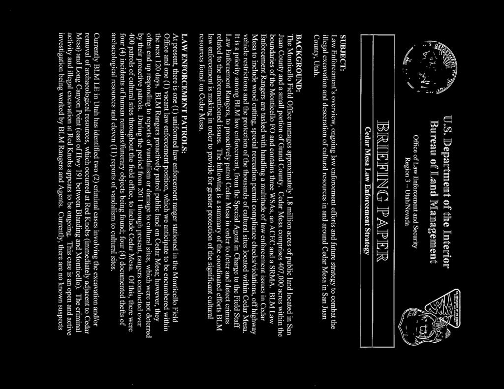
1 The Advisability of Designating the Bears Ears as a Monument Under the Antiquities Act Procedural Requirements, Governmental Prerogatives, and a Required Statutory Process Prepared for: County Commission San Juan County, Utah 117 South Main Street Monticello, Utah October, 2016 Complex Problems Solved Well Stillwater Technical Solutions PO Box 93 Garden City, KS Principal Author: J.R. Carlson Principal Researchers & Contributing Authors: Norm MacLeod Angus McIntosh, PhD Alva Byron Clarke, IV, J.D., Blue Mountain Diné Community Group
2 Table of Contents 1.0 INTRODUCTION Background Land Management & Land Use Planning Situation Appraisal; Issue Identification Purpose and Approach STATUTORY BACKDROP The Federal Land Policy and Management Act The Data Quality Act The Antiquities Act The National Environmental Policy Act DISCUSSION Proposal by the Bears Ears Intertribal Coalition Jurisdiction Damage to Antiquities Legislative Considerations Valid Existing Rights Grazing Allotments SITLA Lands Implied Reservation of Water Rights-of-Way Uranium Other Considerations Human Health, Safety & Welfare NPS Backlog; Interagency Cultural Issues CONCLUSIONS RECOMENDATIONS Table of Authorities List of Exhibits Exhibit 1: Maps Exhibit 2: List of Inholdings Exhibit 3: Land Use Plans in San Juan County Exhibit 4: MOA Between SJC & The Navajo Nation Exhibit 5: Briefing Paper: DOI BLM Office of Enforcement & Security Exhibit 6: SJC Lands Council: Items for PLI Legislation Exhibit 7: Impact Letters from Two County Sheriffs Exhibit 8: Cultural & Fiscal Problems at NPS Exhibit 9: San Juan County Resolutions ii
3 EXECUTIVE SUMMARY Over the past twenty years, the quantity and area proposed for monuments in the United States has increased dramatically. Withdrawal of what are supposed to be public lands from productive use has kindled scrutiny of the President s discretionary authority, raised questions about the procedural responsibilities of administrative agencies, and focused review on the Federal government s responsibility to inventory and safeguard property inholdings that have valid existing rights. Upon bringing the Antiquities Act under Title 54 of the United States Code in the National Park Service body of statutory law, the Congress eliminated potential for the Antiquities Act to be considered a stand-alone privilege enjoyed by the President. The 2014, in para materia adoption of the Antiquities Act into the National Park Service Statutes now requires the Secretaries of Interior and Agriculture to implement the procedural, duediligence obligations that balance human and natural environments, preserve valid existing rights, and which demonstrate deference for State and local jurisdictional prerogatives. The methodological language of the Antiquities Act presupposes an inventory of private inholdings has been conducted, that those interests have been distinguished from lands owned and controlled by the Federal government, and that inholding owners have been given opportunity to relinquish their properties prior to the designation process. Similarly, the logic of the Antiquities Act requires advance understanding of the areal extent of the tract, knowledge of the nature and care required for the objects, and a minimum, scientific understanding of the occurrence and relationship of the objects to non-federal inholdings. A non-governmental organization (NGO) of Native American tribes has proposed designation of a 1.9 million acre national monument in San Juan County, Utah. We reviewed that proposal in a procedural, statutory context using the historical definition of public lands, congressionally-mandated land use planning prerogatives, and a county inventory of valid existing rights that occur in the proposed monument area. The proposal by the Coalition - though well intended - is severely deficient, requesting actions by the Secretaries and the President that are clearly contrary to law. As an NGO, the Coalition lacks jurisdiction to make the request, and the proposal itself disregards no less than 18 land use planning efforts. If carried forward, the Coalition s plan would preempt agreements between San Juan County and the Navajo Nation and circumvent the role and jurisdiction of State and local governments in land use planning. With respect to documentation, the proposal asserts an urgency disproved by governmental reports, and the 1.9 million acre area proposed for the monument incorporates vast areas of public, private and patented properties that enjoy longstanding, valid existing rights. This survey demonstrates that for purposes of a monument designation, grazing allotments (districts) are a limited-fee, surface title property, and as a result such lands are not owned or controlled by the Federal government. As a consequence, grazing allotments in San Juan County are property having valid existing rights, are subject to State and local jurisdiction, and should be inventoried and managed in the San Juan County Master Plan. Our finding that grazing allotments do not constitute lands owned or controlled by the Federal government has implications that reach far beyond presidential designation of monuments. Federal land management agencies should be required by Congress, State and local governments to review and revise their resource, land use, and land management programs to accommodate historical statutory definitions and accept grazing allotments as real property with valid existing rights.
4 Introduction 1.1 Background - San Juan County is the largest county in Utah, occupying an area of approximately 7,933 square miles (5,077,120 acres). San Juan County is characterized by an interspersed patchwork of grazing districts, wilderness lands, state and national recreation areas, state parks, two national monuments, national conservation areas, and the Manti-La Sal National Forest. For its part, the Manti-La Sal National Forest contains the watershed that the cities of Monticello and Blanding depend upon to meet their entire culinary water needs. A 1.9 million acre region within San Juan County s jurisdictional boundaries has been proposed for designation as a national monument under the Antiquities Act by the Bears Ears Inter-Tribal Coalition 1 (Coalition), a regional consortium of five Native American tribes. The proposed monument contains approximately 1,411,000 acres of Bureau of Land Management (BLM) lands, 155,000 acres of National Park Service (NPS) holdings, 366,000 acres of US Forest Service (USFS) administrated lands, and 151,000 acres of Utah School and Institutional Trust Lands Administration (SITLA) lands. 2 (Exhibit 1) Government-managed lands within the proposed monument are interspersed with vast areas of private inholdings, including forty-three (43) grazing allotments, no less than 661 appropriated water-right diversion points, the sole operating uranium mill in the United States, multiple oil and gas production areas, and approximately 18,000 acres of patented property. (Exhibit 2) Right-of-way access within the proposed monument boundary includes a network of State Highways, State-classified B and D roads, and RS-2477 roads. Of the 3,542 combined road-miles within the proposed monument area, some roads possess in-perpetuity rights-of-way, others have permanent easements or pending easement-applications, and still others maintain rights-of-way predating Utah statehood in January, Demographically, San Juan County contains a near-equal distribution of Native American (51%) and Anglo (45%) populations, with the remaining percentage split among other ethnicities. Economically, San Juan County ranks 29 th out of 29 Utah counties with a per-capita, annual income of approximately $23,244. Approximately 29% of San Juan County residents reportedly fall below the Federal poverty line. 4 1 Proposal to President Barak Obama for the Creation of Bears Ears National Monument. The Bears Ears Inter-Tribal Coalition. October 15, List of Federal, State, Private and Tribal Holdings Data. San Juan County, Utah Surveyor s Office. August 25, ibid. Utah County Surveyor Economic Report to the Governor. The Utah Economic Council. 1
5 Land Management and Land Use Planning - Land use management and planning within San Juan County is characterized by a multi-layered, diverse collection of Federal, State and local land planning interests with each having its own discreet area of responsibility. San Juan County has identified no less than eighteen (18) separate land use, land management, and wildlife management plans within its jurisdiction. (Exhibit 3) San Juan County maintains a comprehensive, land use Master Plan (MP) and the County is actively engaged in land use planning with Federal and State agencies and the Navajo Nation. 5 The Navajo Nation and San Juan County have an ongoing Memorandum of Agreement (MOA) for joint land use planning and land management throughout the County. The San Juan County/Navajo MOA specifically addresses collaborative management of cultural resources, land use planning of recreational areas, and joint participation in SITLA and Federal land exchanges and transfers 6 (Exhibit 4). San Juan County is currently revising its land use and management MP. With this revision, San Juan County is considering alternatives for integrating the BLM s 2008 Resource Management Plan (RMP) and planned revisions to the USFS Manti-La Sal National Forest Plan with County planning processes through the assure consideration, assist-in-resolving and attempt consistency mandates of the Federal Land Policy and Management Act (FLPMA). 7 The sheer volume, overlap and layering of multiple land use planning efforts in San Juan County raises questions as to the effectiveness of any one effort. Even though natural systems do not accommodate manmade political boundaries, the United State Federal code - through a collective, statutory body of law - requires Federal agencies to respect, defer to and defend State and local jurisdictional boundaries. 1.3 Situation Appraisal; Issue Identification - Native American ruins, artifacts and other sites may be located within the jurisdictional boundaries of San Juan County. Governmental reports have referred to objects in the vicinities of Cedar Mesa, Red Knobs, Indian Creek, Alkali Ridge, Montezuma Creek, Long Canyon Point and other areas, with the actual number of sites varying considerably. 5 San Juan County Master Plan. San Juan County, Utah. March, Memorandum of Agreement Between San Juan County, Utah and Navajo Nation. May 5, USC 1712(c)(9). 2
6 Despite the reported, significant quantity of objects and artifacts in San Juan County, over a six-year period Federal investigators have identified two (2) criminal-level excavations, four (4) incidents of funerary excavations, four (4) thefts of archeological resources, and eleven (11) reports of vandalism. 8 Of these macabre activities, some are thought to be historical in nature, occurring well before discovery and reporting (Exhibit 5). Discrepancies between claims of "rampant looting" made to government agencies by environmental groups and facts documented by local BLM investigators began to emerge in May, 2015, when San Juan County law enforcement wrote a letter to a local newspaper (Exhibit 7). The availability, reliability, and quality of documentation supporting claims is further explored in section 3.1. In October, 2015, representatives from five (5) regional Native American tribes proposed that the President of the United States (POTUS) withdraw 1.9 million acres 9 of lands within San Juan County s boundaries under the authority of the Antiquities Act of and Title 54 of the National Park Service Preservation Statutes. 11 Of the five tribes comprising the Coalition, only two possess lands within the proposed national monument boundaries for a total of 4,818 acres. 12 The Coalition's proposal to withdraw 37% of the surface area of San Juan County from current uses raises national-level policy, technical, procedural, jurisdictional, property, health and safety, and local-sovereignty related questions. We explore these questions in context of Federal statutory requirements. In its proposal, the Coalition recommends that the POTUS create a new Federal Entity - a quasi-governmental agency - whose existence has no precedent and the authority for which cannot be traced to Federal statutes. The new entity is proposed to be managed by a salaried, eight-member commission - one member from each tribe - and three participants from Federal agencies. No participation from State or local governments is contemplated, either during the designation process or in subsequent operations, land-management, or decision-making. With respect to funding, the Coalition points to the interest of unnamed philanthropic foundations before transitioning into a request that the POTUS "direct agencies to use their best efforts to provide funding under the Indian Self- Determination Statutes and other authorities for collaborative management at Bears Ears." 13 The proposal is silent on the Congressional land withdrawal and appropriations process associated with land transactions of the magnitude contemplated by the Coalition, and no budgetary or cost estimates were included in the proposal. 8 Briefing Paper. US Department of Interior, Bureau of Land Management. Office of Law Enforcement and Security, Region 3. 9 Proposal to President Barak Obama for the Creation of Bears Ears National Monument. The Bears Ears Inter-Tribal Coalition. October 15, USC USC Sec ; (Pub.L , S3, December 19, Stat ) 12 Navajo Nation has 18 acres and the Ute Mountain Ute tribe has 4,800 acres in the proposed boundary. SJC, Utah Surveyors Office. 13 Ibid. Proposal to President Barak Obama. Page 30. 3
7 Historically, a proposal of the quality of that submitted by the Coalition would not be significant enough to merit Presidential attention. In the context of elevated jurisdictional tensions, prerogative incursions, and even proposed Federal rules that are contrary to Federal statutes, a deeper, more organic problem exists Purpose and Approach - Our approach examines the Coalition s proposal in the context of ongoing encroachment by Federal land management agencies and the Executive Branch on the prerogatives of State and local governments. In seeking solutions to a complex, emotionally-charged situation, we avoid assigning blame or ascribing intent. Our objective is to survey the Coalition's urgent claim for artifact protection in the historical, jurisdictional, and statutory context of rightful Federal, State, and local land use planning prerogatives. Following review of the Coalition's proposal we apply the statutory, procedural framework required of Federal agencies during the designation process and that are protective of human health and the environment. Finally, we conclude with solutions that utilize the existing, jurisdictional, San Juan County land use planning and management system Comments, Statutory Analysis and Recommendations on BLM's 2.0 Planning Rule. Stillwater Technical Solutions. May,
8 Statutory Backdrop 2.1 The Federal Land Policy and Management Act - Through the 1976 Federal Land Policy and Management Act (FLPMA), Congress consolidated a century of land-management statutes into one comprehensive body of law to be implemented by the Secretaries of the Departments of Interior and Agriculture. FLPMA is the controlling statutory mandate governing Federal land use planning, land withdrawals, range allotment permitting, minerals management, land set-asides, prior existing rights, and protected rights-of-way on or over public lands. Public lands and antiquities proposed for withdrawal by the POTUS are to be reviewed in accordance with the provisions of this [FLPMA] Act 15 and managed according to the mandates of FLPMA, the Archeological Resources Protection Act, 16 the National Historic Preservation Act (NHPA), 17,18 and Title 54 of the National Park Service Preservation statutes. 19 At the state level, the lead authority for artifacts management is the State Historic Preservation Office (SHPO). Prior to initiating Major Federal (withdrawal) Action, 20,21 the Secretary(s) are to implement the Environmental Assessment (EA) mandates of the National Environmental Policy Act (NEPA), 22 codified in rule by the Council of Environmental Quality (CEQ). 23 All statutory responsibilities surrounding monument designations are to be undertaken in the context of minimum data quality and scientific standards of the Data Quality Act and Department of Interior policies. The NEPA requirement is more fully applied throughout this survey. After five years of deliberation and in response to the conclusions of the Public Land Law Review Commission, 24 the 94 th Congress changed the definition of what constitutes public land. This change - central to implementation of the doctrine of multiple use and its list of limited, principal uses - was necessary because Congress determined that most lands and minerals throughout the west had been allocated, and as a result, significant portions of the public lands now exist in split estate ownership. Following promulgation of FLPMA, it is the property doctrine of split-estates that determines which governmental entity has controlling, jurisdictional authority over surface land. Federal land management agencies are limited to commercial timber and subsurface mineral estate, whereas State and their political subdivisions have USC 1701(a)(3) USC 470aa-mm. 17 Pub. L ; 80 STAT.915; 16 USC Executive Order Protection And Enhancement Of The Cultural Environment. May 13, Pub. L , 3, Dec. 19, 2014, 128 Stat CFR CFR USC CFR One Third of the Nations Land. A Report to the President and to the Congress by the Public Land Law Review Commission. June,
9 jurisdiction over private property interests, including grazing allotments. It is only within National Parks, where private inholdings have been acquired thorough relinquishment, condemnation or purchase - or where the State has ceded its authority - that Federal land management agencies possess exclusive jurisdiction over surface lands. Over time, Federal agencies have lost sight of their limited, statutory authority to regulate the surface portion of split-estate lands, resulting in encroachments. Encroachments have taken place through a variety of mechanisms, including administrative orders, errant regulations and unchecked policy directives, with a corresponding lack of resistance at the State and local level. Jurisdictional confusion can be traced to a non-understanding of the origin and longstanding history of the definition of "public lands" in Federal statutes and case law. The relationship of public lands to split estates, reservations, and other land appropriations was defined in the Federal Water Power Act of 1920 and since has been abundantly adjudicated in case law: "most enduringly public lands have been defined as those lands subject to sale and other disposal under the general land laws" 25 and, Public lands means such lands and interests in lands owned by the United States as are subject to private appropriations and disposal under public land laws. It shall not include "reservations" as hereinafter defined. "Reservations" means national monuments, national parks, national forests, tribal lands embraced within Indian reservations, military reservations, and other lands and interests in land owned by the United States and withdrawn, reserved or withheld from private appropriation and disposal under the public land laws When the 94th Congress revised the definition of "public lands" it had in view that split-estate conditions, reservations for National Monuments and Parks - including grazing allotments - not be included in the definition of what constitutes "public lands." 27 This led to the current FLPMA definition: 25 Utah Div. Of State Lands v. United States. 482 US 193 (1987) Stat Agricultural Entry of Mineral Lands Act 1914; Stock-Raising Homestead Act 1916; Mineral Leasing Act 1920; Federal Power Act [See Kinney Coastal Oil v Kieffer, 277 US 488 (1928); Watt v Western Nuclear, 462 US 36 (1983)] 6
10 The term public lands means any land and interest in land owned by the United States within the several States and administered by the Secretary of the Interior through the Bureau of Land Management, without regard to how the United States acquired ownership The addition of interest in land and removal of "subject to appropriation and disposal" language reflected the need for comprehensive land use planning that respects the split estate nature of pre-existing mining claims, land interests, property rights, and land uses that had been granted throughout 200 years of history. In promulgating FLPMA, the Congress moved Federal land planning closer to State and local jurisdictions, intending co-planning with Federal agencies to be carried out on an equal-footing basis. FLPMA places Department of Interior as a partner for the overall process; e.g., to be reviewer and coordinator of land use plans, including Federal plans. Complications have arisen because county governments have not adequately understood the responsibilities, technical requirements, or limits of Federal control in land use management and planning. The combination of unrestrained growth of administrative government and a wholesale, shallow understanding of the bright-line limits of Federal, State and local prerogatives has led to confusion in land use planning. This situation can be restored through a clear understanding of history and firm, ground-up assertion of rightful prerogatives. Recognizing the intermingled, pre-existing status of water rights, easements, grazing allotments, mining claims, timber operations and various private inholdings, the 94th Congress established a hierarchal system that provides for the diverse land use interests around a central philosophy of productivity 29 - not sequestration. To that end, the limited FLPMA doctrine of principal use 30 establishes a first-among-multiple-use hierarchy for land use planning within the grazing districts of San Juan County: 1. Domestic livestock grazing; 2. Fish and wildlife development and utilization; 3. Mineral exploration and production; 4. Rights-of-way; 5. Outdoor recreation; and, 6. Timber production. The first in the hierarchy of FLPMA principal uses is domestic livestock grazing. Federal courts have determined allotments for livestock grazing to be limited-fee titles that constitute a property right. 31 As a FLPMA-protected, pre-existing USC 1702 (e) USC 1702 (c) USC 1702 (l). 31 US v. Estate of Hage. No 2:07-CV RCJ P. 41 D Nev. May 24,
11 property right, grazing allotments and range improvements in San Juan County are surface-right entitlements that enjoy legal and regulatory safeguards so long as they are exercised. 32,33 Because the 43 grazing allotments in San Juan County are limited-fee title, surfaceestate entitlements that do not meet the definition of public lands, those surface allotment lands, absent Federal purchase, condemnation or due process, are excluded from a monument designation as they are not lands fully owned or controlled by the Federal Government. From a land management perspective, further investigation is needed to identify and segregate surface timber interests and Federally-owned minerals from water rights, grazing allotments and other private holdings that occur in split estate. This inventory will vastly reduce the management claim of Federal agencies to surface lands in San Juan County and ideally take place during revision of the San Juan County MP. 2.2 The Data Quality Act - The Data Quality Act (DQA) 34,35 requires administrative agencies to establish and maintain minimum standards and internal policies that afford local government and the public a process through which information can traced, corrected and verified. Information which could inform major Federal actions or executive decisions - such as the proposed Bears Ears National Monument designation - must be of high quality, reliability, transparency and veracity: The more important the information, the higher the quality standards to which it should be held, for example, in those situations involving influential scientific or statistical information. 36 Congress has established a minimum, DQA threshold consisting of four components: 1) Quality; 2) Utility; 3) Objectivity; and, 4) Integrity. 32 Pub. L Sec. 701 (a). 33 Pub. L Sec. 701 (h). 34 Section 515(a) US Treasury and General Government Appropriations Act. Pub. L H.R. 5658; 66 FR September 28, Ibid. Federal Reg.Vol. 66, No
12 The Objectivity component requires information used in natural resource planning to identify all sources of information, standards for models, data, financial information; information in statistical contexts are to be specifically documented so the public can assess for itself whether there may be some reason to question the objectivity of the sources. Objectivity means information must be clear, complete, and unbiased with sources being identified. To be reviewable, information must first be made available. The "Reproducibility" requirement states that information must be capable of being substantially reproduced subject to an acceptable degree of imprecision. This DQA requirement means that information for a proposed monument, such as inventory of property inholdings and studies for proper care and management - must be available from common and readily-available sources and such information must be replicable. An example of the "reproducibility" standard includes information-sourcing of the scientific basis used to determine the monument boundary. The "Utility" requirement pertains to usefulness. Information from Federal agencies - and by extension the POTUS - needs to consider the uses of the information not only from the perspective of the agency, but also from the perspective of the public. An example of the utility component is that information must be specific for the purpose, not random, unrelated citations or references. The "Integrity" component pertains to security of information such that it is not subject to compromise. In his Federal Register notification for the proposed P2R Planning Rule, the BLM director proposed diluting and altering existing Federal standards for information dissemination under the Data Quality Act. Specifically, the Director cites the example of Traditional Ecological Knowledge (TEK) - knowledge from a specific location acquired by indigenous and local people who have had direct contact with the environment - as a type of information that constitutes high quality information. TEK falls well short of the Federal definition of what constitutes science and it does not meet the Quality, Utility, Objectivity, and Integrity standards in DQA The Antiquities Act - The Antiquities Act (AA) was promulgated by the Congress in 1906 and amended in 1950 to exclude extensions to existing or designations of new national monuments in Wyoming without Congressional authorization. 38 In 2014, the AA was reauthorized by Congress and brought under Title code of the National Park Service Preservation statutes. 40 In placing the AA under Title 54, Congress removed any potential for the AA to be considered a stand-alone, executive 37 Comments, Statutory Analysis and Recommendations on BLMs Planning 2.0 Rule. Stillwater Technical Solutions. May, pps USC (d) USC Sec STAT Public Law December 19,2014. "National Park Service and Related Programs." 54 USC
13 prerogative; the AA is now a corpus juris part of the National Park Service statutes, and all monument designations are subject to the standards, procedures, human protections, and regulatory processes - in para materia - as all other Department of Interior National Park Service programs. The purpose of the AA is to set aside objects, landmarks, and structures for care and management that have been identified in small, discreet tracts of Federal lands. The scope of protection offered by the AA is limited to objects, items and structures; withdrawal of public lands, natural resources or lands beneath landmarks is to take place in full compliance with FLPMA mandates. 41,42 The statutory construction and semantics of the AA are methodological in imposing procedural and technical obligations upon the POTUS - and by extension the Secretaries of Interior and Agriculture. The simple AA language presupposes up-front, due diligence has been accomplished prior to proclaiming the designation; as example, it is not possible to minimize a parcel size without first understanding the relationship of public lands to State and private inholdings. Likewise, "proper care and management" needs cannot adequately be determined without first assessing the occurrence, nature, and best management practices for the object(s) to be protected. Finally, in order to properly exercise their right of relinquishment, inholders have a fundamental right to notification while their property interests have full market value - a right that is impossible to exercise without an accurate, pre-inventory 43 of objects, Federal lands, and State and private holdings. The specific language of AA clearly precludes designate-then-investigate actions. In support of the monument designation process and statutorily provided, local land use planning role, we have developed a 6-part test. The test applies the core procedural tenets of the AA that must be undertaken prior to the designation being made, and can be applied to any monument proposal in the United States, its territories, and possessions. While the details of each situation vary, the objective behind the test is to illuminate the principles required of the Secretaries of Interior and Agriculture - and by extension, the POTUS. These statutory requirements balance safeguards of valid exiting rights, inholdings, private property, notification, and local land use planning prerogatives with the cultural and secondary value protections any AA designation might have USC 1702(j) USC 1714(a)-(l) USC 1701(a)(2) 10
14 The Antiquities Act 44 - (a) PRESIDENTIAL DECLARATION - The President may, in the President's discretion, declare by public proclamation historic landmarks, historic and prehistoric structures, and other objects of historic or scientific interest that are situated on land owned or controlled by the Federal Government to be national monuments. (b) RESERVATION OF LAND - The President may reserve parcels of land as a part of the national monuments. The limits of the parcels shall be confined to the smallest area compatible with the proper care and management of the objects to be protected. (c) RELINQUISHMENT TO FEDERAL GOVERNMENT - When an object is situated on a parcel covered by a bona fide unperfected claim or held in private ownership, the parcel, or so much of the parcel as may be necessary for the proper care and management of the object, may be relinquished to the Federal Government and the Secretary may accept the relinquishment of the parcel on behalf of the Federal Government. Antiquities Act: Procedural Requirements Test - a. What credible, reliable, replicable and readily-available scientific studies have been performed to assess the range, occurrence and proper care of objects in the area proposed for designation? b. Through what means has the Secretary(s) created and published inventories that distinguish public land from inholdings of reserved water right(s), mining or mineral claims, State and private property inholdings, grazing allotments, pre-1976, in-perpetuity easements, and/or rights-of-way? c. How have parcels of public land been delineated such that the relationship of inholdings can reasonably be understood and the smallest area compatible with proper care and management of the objects responsibly be determined? d. By what means, measures and timing did the Secretary notify government, corporate and/or private property in-holders of their right to participate in or opt out of the relinquishment process? e. What local input has been sought to document what constitutes proper management of the objects for the protections being sought? f. What State and local political subdivision inholdings have been identified that could experience tax, impaired right-of-way, affected water right, safety, or other derogation as a result of a premature or inappropriate designation? USC Subtitle III: National Preservation Programs. Sec
15 The National Environmental Policy Act - The National Environmental Policy Act of 1969 (NEPA) 46 and implementing regulations from the Council on Environmental Quality (CEQ) 47 mandate balancing of human and natural environments during decision making by Federal agencies. The policy of the United States, mandated through NEPA, is to assure protection and productivity of the human and natural systems in the context of general human welfare and harmony with existing social, economic, and cultural systems. it is the continuing policy of the Federal Government, in cooperation with State and local governments, and other concerned public and private organizations, to use all practicable means and measures, including financial and technical assistance, in a manner calculated to foster and promote the general welfare, to create and maintain conditions under which man and nature can exist in productive harmony, and fulfill the social, economic, and other requirements of present and future generations of Americans. 48 and,... to use all practicable means, consistent with other essential considerations of national policy, to improve and coordinate Federal plans, functions, programs, and resources The POTUS, by definition, is not a Federal agency and is exempt from NEPA mandates 50 during the routine exercise of his office. For their part, the Secretaries of Interior and Agriculture are not exempt from NEPA requirements when carrying out their responsibilities under Title 54, 51 and this includes monument designations. A simple-to-ask but complex-to-answer question is whether the POTUS, by virtue of his office, has the Constitutional or Congressional latitude to override or negate the statutory mandates required of the Secretaries of Federal agencies put another way, can the POTUS circumvent specific activities that Congress mandated Federal agencies to implement? We believe the POTUS is constrained by the statutory mandates governing the Federal agencies who act on his authority and in his stead. Once a statutory bright line has been breached, there remains no objective limits by which local government, Congress or the courts can measure his actions, decisions or behavior. 45 Pub.L Sec. 701 (a) USC CFR USC 4331(a) USC 4331(b) CFR USC Sec et.seq. 12
16 Should the POTUS fail to comply with procedural mandates binding subordinate Secretaries, such an example lends tacit approval for subordinates to disregard laws, which in turn leads to the degradation at all levels of government. As the planning process for the Manti-La Sal National Forest proceeds - and if the Coalition's proposal gains consideration - the procedural requirements of NEPA apply to the Secretaries of Interior and Agriculture at the earliest possible opportunity. 52 As result, we recommend San Juan County consider requesting Co- Lead Agency status during the EA/EIS and include the process and results, as appropriate, in revision of the MP CFR
17 Discussion 3.1 Proposal by The Bears Ears Inter-Tribal Coalition Jurisdiction On October 15, 2015, representatives from the Hopi Tribal Council, Navajo Nation, Ute Indian Tribe Business Committee, Ute Mountain Ute Tribal Council, and Pueblo of Zuni tribes submitted to President Obama and the Departments of Interior and Agriculture a proposal 53 to withdraw 1.9 million acres of land currently within the jurisdictional boundaries of San Juan County. The proposal was clearly prepared with a heart of genuine concern for the history and safeguarding of the objects and artifacts contained within discreet areas of the proposed Bears Ears Monument area. STS does not question the spirit or authenticity of the concerns exhibited in that proposal; however, the purpose of our analysis is to apply Federal statutory requirements that bind the Secretaries of Interior and Agriculture - and therefore the POTUS - to the procedural processes and jurisdictional deference in land use planning. In requesting adoption of its collaborative management concept, the Coalition proposes an additional, quasi-governmental layer of land use planning that would preempt at least 19 existing land use plans - including ten plans of four Federal agencies. The Coalition's proposal would preempt an existing Memorandum of Agreement (MOA) between the Navajo Nation and San Juan County whose express purpose is to include objects of historical value in the land use and planning process. Further, the proposal provides no role for statutorily mandated participation from existing political subdivisions of the State of Utah, San Juan County, or other qualified local government entities Damage to Antiquities The factual basis for the Coalition's "more than a dozen serious looting cases were reported between May, 2014 and April 2015" was not included or referenced in the proposal. The assertion of "rampant looting" contrasts greatly with reports from local law enforcement (Exhibit 8) and a US Department of Interior briefing paper on looting and pillaging activities (Exhibit 5). When the cases documented by law enforcement are weighed against the varying, reported quantity of sites, the magnitude of the Coalition's urgency claim pales, particularly against the backdrop of foreseeable, adverse impacts to the human environment that could result from reactionary-based decision-making. Indeed, the negative experiences documented by Garfield County should lead Federal agencies to exercise caution and full procedural compliance to ensure adequate human protections (Exhibit 8). 53 Proposal to President Barak Obama for the Creation of Bears Ears National Monument. The Bears Ears Inter-Tribal Coalition. October 15,
18 With respect to the monument boundary proposed by the Coalition, neither the map by Grand Canyon Trust nor the proposal itself provides data, replicable details, or calculations as to how the boundary limits were determined or how the proposed 1.9 million acres could possibly meet the smallest-possible-area and land-controlled-by-federal-government requirements for monument designations. In glaring contrast, we conclude the interspersed grazing allotments, SITLA lands, water rights, and valid, pre-existing rights-of-way pose significant additional complexities to the designation process - one that must be examined through scientific and procedural means Legislative Considerations Significant land use legislative activities have been taking place at both the Utah State and national levels. In 2015, Utah passed H.B. 393, a statute that created energy zones within San Juan County and amended the Utah resource management plan. At the national level, Congressman Rob Bishop has introduced into the House Natural Resources Subcommittee H.R. 5780, the Utah Public Lands Initiative (PLI) and that legislation is progressing through the House of Representatives. H.R. 5780, if passed, would establish eleven new national conservation areas (NCAs), six special management areas, designate forty-one new wilderness areas, add land to Arches National Park, create a new national monument, and establish a new national recreation area. The product of a large, multi-group effort, the PLI is astonishingly detailed in scope, offering much to many stakeholders responsible for its development. For their part, environmental groups and the Department of Interior oppose specific language in the PLI that would transfer authority for energy permitting to the State, limit BLM's ability to manage some grazing activities, and grant RS 2477 roads and rights-of-way. Also drawing ire are provisions that allow limited motorized access in wilderness areas and limit BLM's ability to close roads, trails, and corridors. San Juan County, through its Lands Council, has contributed positively to development of the PLI (Exhibit 6). Specific contributions to the PLI include designation of two NCAs, several wilderness areas, and identification of productive energy zones consistent with newly enacted State statutes. The San Juan County Council and Commission has expressed particular interest in the transfer of the McCracken mesa mineral rights from the Federal government to the Utah Navajo Nation Trust Fund (UNTF), continuation of livestock grazing allotments during future land transfers, inclusion of setbacks (positive buffer zones) from rights-of-way, transfer of infrastructure and other interests. Other initiatives identified by the San Juan County Commission include interests that would revise how mineral royalties are allocated within the State, protection of cultural sites such as the White Mesa and the Allen County Burial Grounds, and allocation of some SITLA land to the Southern San Juan Paiute Tribe. These 15
19 important, local, cultural items must not be lost in the fervor of legislative negotiations, language adjustments or changes that accommodate special interest groups. In our brief exposure to the history of San Juan County s Native Americans, we observed several economic injustices and multi-generational, cultural injuries - wounds we believe would be exacerbated if the Coalition's proposal results in a national monument. We do believe San Juan County should convene a subcommittee within its management planning process to collect, assess, recommend and oversee cultural protections consistent with the purpose and objectives of land use planning. 3.2 Valid Existing Rights Grazing Allotments The Agricultural Entry of Mineral Land Act of 1914, 54 the Mineral Leasing Act of 1920, and the Stock-Raising Homestead Act of 1916 created a split-estate condition that segregated mineral rights from the surface-estate on public lands. The legislative philosophy behind these acts, carried forward in the Congressional record and codified in FLPMA, granted the surface-fee title to agriculture and ranching, while reserving merchantable timber and the mineral estate to the United States. 55,56 The intent of Congress in severing "Limited Surface fee title for Agriculture and Ranching" while reserving to the United States the mineral estate and commercial timber was to recognize, through allocation of limited surface ownership interests, ranching and livestock grazing as having a longstanding history, priority, and value in American culture. Grazing allotments are a limited-fee, surface title property interest that enjoys substantive and procedural property rights. 57 In areas where grazing allotments occur as surface estate, such as throughout San Juan County, those grazing allotments constitute valid, pre-existing, property rights not under the ownership or control of Federal agencies or the United States. As a result, grazing rights may not be encumbered or revoked without procedural or due-process actions, adjudications, or compensation. 58 If a monument is to be proposed, 59 surface-estate grazing allotments must first be inventoried and the ownership characteristics of each allotment determined. If, as part of procedural due diligence, the POTUS elects to proceed with monument designation, owners of grazing allotments are to be notified of their opportunity to relinquish as would be the case with any other property right Stat 267, 38 Stat 609, 38 Stat Kinney Coastal Oil v. Kieffer, 277 US 488 (1928). 56 Watt v. Western Nuclear, 462 US 36 (1983). 57 US v. Estate of Hage, No 2:07-CV RCJ P. 41 D Nev. May 24, USC 1702 (f); 43 USC 1769 (a). 59 USC Sec
20 The prolific confusion surrounding the history of grazing districts and the property rights of grazing allotments lends to the need for San Juan County to establish the occurrence and scope of grazing-allotment holdings throughout the county, including within the Manti-La Sal National Forest. We recommend inclusion of a grazing allotment inventory in the San Juan County Land Use and Management Plan as well as notification of Federal and State agencies of County policies, mapping, and management ordinances, such that those entities may attempt consistency through inclusion of grazing allotment in their planning process SITLA Lands The Utah School and Institutional Trust Lands Administration (SITLA) is an independent, revenue-generating State agency established to manage lands granted to Utah by Congress. SITLA manages 3.4 million acres of state trust lands, and an additional 1 million acres of mineral estate. Taxable activities on SITLA lands support twelve state institutions and include real estate development and sales; oil, gas, and mineral lease rents and royalties; renewable energy projects and surfaceestate sales, leases, and easements. There are approximately 151,000 acres of revenue-generating, SITLA lands interspersed throughout the monument area proposed by the Coalition (Exhibits 1 and 2; Map 3). SITLA parcels - being State owned - do not constitute land owned or controlled by the Federal Government, and cannot be legitimately withdrawn for a monument without an inventory, notification-for-relinquishment, due-process or tax compensation review. 60 In requesting the POTUS withdraw 1.9 million acres of lands containing 151,000 acres of interspersed SITLA inholdings, the Coalition is indirectly asking the Secretaries of Interior and Agriculture to violate Federal procedural land use and human-protection statutes without the benefit of study, notification, due process, or compensation. Because monuments - over time - have been demonstrated to eliminate revenueproducing activities, the impacts to human health, the human environment and the state economy must - prior to proposing a monument - be investigated through the NEPA Environmental Assessment (EA) or Environmental Impact Statement (EIS) process. (It seems unconscionable to us that any Federal agency would take the position that NEPA does not apply, particularly in the context of SITLA, taxrelated impacts on the State economy.) The Coalition's major objective to keep most of the [1.9 million acres] of the Bears Ears roadless and pristine 61 is contrary to established law as it advocates the POTUS - through the Secretaries of Interior and Agriculture - to arbitrarily encumber or close legitimate access corridors, including 79 miles of easementholding, SITLA roadways. Granting the Coalition's broad, unsubstantiated request USC 1701(a)(13). 61 Proposal to President Barak Obama for the Creation of Bears Ears National Monument. The Bears Ears Inter-Tribal Coalition. October 15, 2015.p
21 for a 1.9 million acre Bears Ears monument would result in clear derogation 62 of Utah State authority by terminating - over time - valid SITLA leases, lands, and rights-of-way Implied Reservation of Water Located within the Manti-La Sal National Forest is the surface water collection, storage and distribution system for the Cities of Monticello and Blanding. With the exception of a few intermittent wells, both cities are entirely dependent upon the watershed of the Manti-La Sal National Forest. Water captured in impoundments within the Manti-La Sal National Forest is delivered through a series of conveyances, pipelines and tunnels; water delivery and conveyance infrastructure that resides within easements and rights-of-way have been set aside for that purpose. 63 Within the area proposed for the Bears Ears Monument, the United States has limited, appropriated water rights. Water reserved to the United States in the Manti-La Sal National Forest and the BLM Resource Areas includes set asides for firefighting purposes, culinary use at administrative sites, reservations for a few head of pack stock, and limited-use appropriations at discreet sites as determined by the State of Utah. Historically, surface and ground water rights in San Juan County were severed from the public lands and water appropriation prerogatives are now under the jurisdiction of the State of Utah. 64 In US v. New Mexico (1978) the SCOTUS ruled ranchers in national forests own stock watering rights; 65 in other related case law, ranchers have been determined to own stock watering rights and improvements located on Grazing Allotments. 66 Under the Implied Reservation of Water Doctrine, the Multiple Use and Sustained Yield Act of 1960, and rulings from the Supreme Court of the United States (SCOTUS), the Federal government does not have the prerogative to appropriate water from national forests for recreation, range, fish or environmental uses outside of the State water appropriation framework. In U.S. v. New Mexico, the SCOTUS found it is the intent of Congress to reserve enough water to meet specific uses and no more; that the Federal government is to utilize the State water appropriations process as others, and even pay to purchase water rights under state systems, including monuments Sec.701 Pub.L (g)(6). 63 Personal interview: Blanding City Manger Jeremy Redd and City Engineer Terry Ekker, PE. August 8, California v. United States, 438 US 645 (1978). 65 United States v. New Mexico, 438 US 696 (1978). 66 Fallini v. Hodel, 725 F. Supp 1113 (D. Nev 1989) affm 963 F2d 275 (9th Cir 1992) U.S. 696,
22 Superimposition of a monument over the Manti-La Sal National Forest, as contemplated by Coalition and drawn by Grand Canyon Trust environmental group, 68 would have foreseeable, indirect and long-term adverse effects on Monticello and Blanding s water conveyance system and water rights by inappropriately superseding state water appropriations, 69 derogation of ditch and conveyance rights-of-way, 70,71 and preemption of state jurisdiction 72,73 over water appropriations and programs. Because Blanding s rights-of-way and Manti-La Sal National Forest watershed conveyance systems do not constitute land owned or controlled by the Federal government, those systems are only eligible for Federal acquisition through relinquishment, procedural actions, due process and/or adjudication Rights-of-Way Ongoing and unencumbered right-of-way access is essential to inholder property rights, civic duties of law enforcement, and the day-to-day operational aspects of managing livestock grazing allotments. Pre-FLPMA, in-perpetuity easements, prescriptive RS 2477 roads, ditches, water conduits, utility routes, and firstresponder corridors across public lands constitute valid, pre-existing, rights not under the ownership or control of Federal agencies or the United States. 74,75,76 Pre-FLPMA right-of-way corridors are real property interests and regulation of those corridors across Federal land resides within the purview and prerogative of State and local jurisdictions. In circumstances where rights-of-way are to be relinquished to the United States, such reversionary actions are subject to normal land transaction, adjudicatory, or compensatory processes. Federal agencies have statutory authority to issue term-limited, revocable FLPMA Title V rights-of-way to control mining activities, commercial timber activities, transportation, mineral transport, communication and similar utilities. We believe it is important, as part of local land use planning, to survey, distinguish, and document rights-of-way in local land use and management plans. As part of the right-of-way process, we recommend San Juan County insist its right-of-way prerogatives be included in Federal land plans through the FLPMA consistency doctrine. 68 Proposal to President Barak Obama for the Creation of Bears Ears National Monument. The Bears Ears Inter-Tribal Coalition. October 15, pg United States v. Krall, 174 US 385 (1899). 70 Pub.L (a). 71 San Jose L.&W. Co. v. San Jose Ranch, 189 US 177 (1903). 72 Sec.701 Pub.L (g)(6). 73 Sec.701 Pub.L (g)(7). 74 Curtin v. Benson, 222 US 78 (1911). 75 Colorado v. Toll, 268 US 228 (1925). 76 United States v. 9, Acres, 220 F Supp 328 (1963). 19
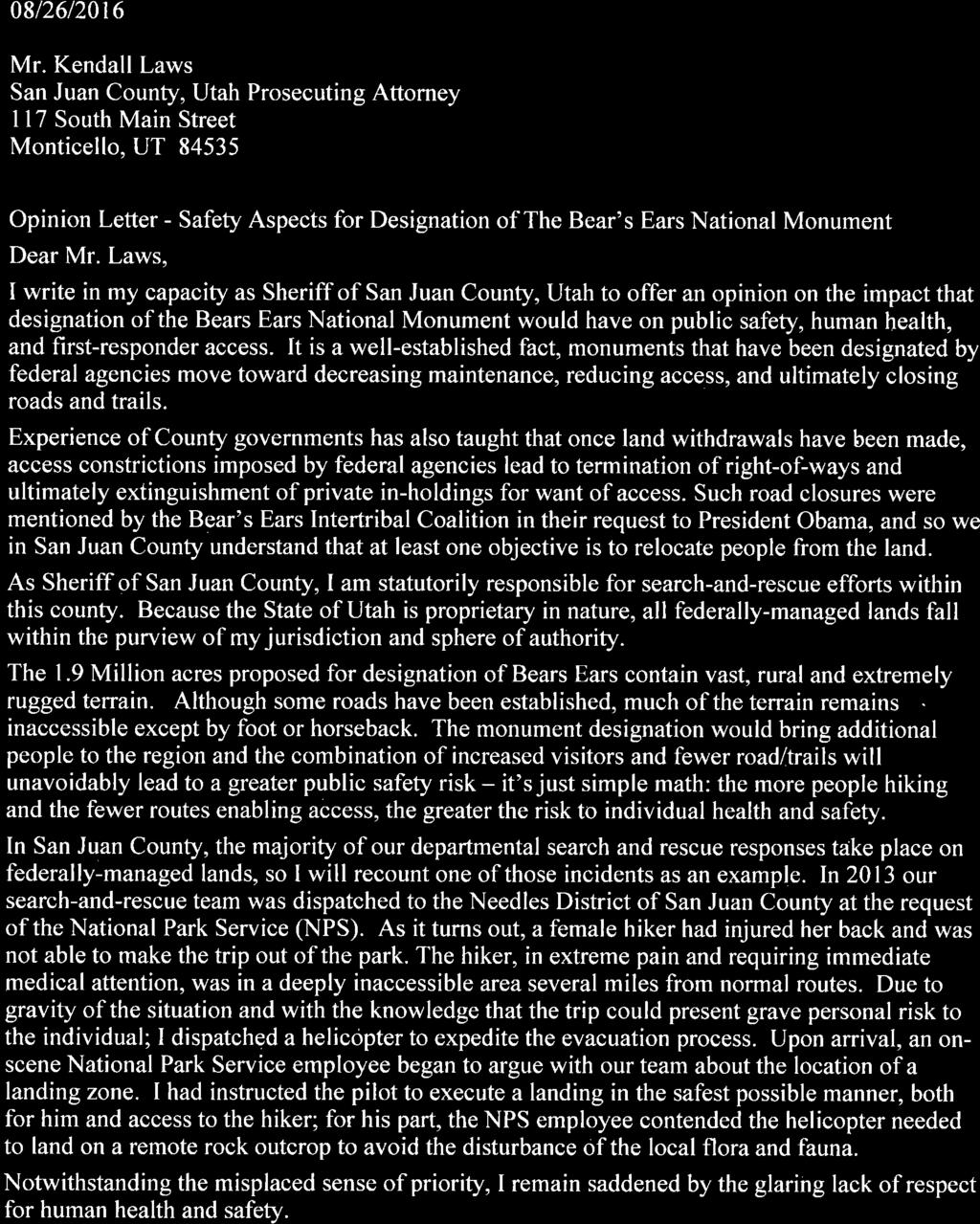
23 Uranium Uranium is a strategic mineral that has both civilian and military uses. In civilian applications, uranium can be processed to facilitate generation of electricity in nuclear power plants; in military applications, uranium has a productive use as a high-density, projectile penetrator. The sole, remaining mill capable of producing conventional uranium is owned by Energy Fuels, Inc. and is located on Highway 191, between Bluff and Blanding - well within boundary proposed by the Coalition for a monument. Because of the strategic importance of uranium to the United States and the economic contribution of productive, life-wage industrial activities to San Juan County, the potential impact of plant closure on the human environment would need to be reviewed thorough the NEPA EA/EIS process if the Coalitions monument proposal were to gain acceptance. 3.3 Other Considerations Human Health, Safety and Welfare - The 10th Amendment to the Constitution and State law vests local sheriffs as the final authority for local law enforcement, including ensuring the health, safety and welfare of citizenry under their charge. We approached two county sheriffs - one having recent experience with a monument and the other from San Juan County - to gain their views on the Coalition's desire to close access routes and rights-ofway corridors. Sheriff Rick Eldridge of San Juan County expressed considerable concern that the combination of more visitors and reduced access resulting from road closures would have detrimental impact on his ability to perform search and rescue activities (Exhibit 8). Sheriff Eldridge then recounted a rescue event where a National Park Service employee - in the midst of an actual rescue effort displayed more concern for protecting plants and dirt than with timely evacuation of a severely injured woman. (In our opinion, someone has a skewed sense of priorities). This view was corroborated and extended by Garfield County Sheriff James Perkins, who is responsible for law enforcement over the Grand Staircase- Escalante National Monument. Sheriff Perkins minced no words in recounting his experience that national monuments lead to civil unrest, economic impacts, employment disparities, degradation of infrastructure, and higher costs due to increasing search and rescue efforts. In his correspondence testifying to the social and economic consequence of monument designations, Sheriff Perkins recounts his department's experience with increasing alcohol and drug use, domestic violence, increased juvenile delinquency, and a 66% drop in high school enrollment (Exhibit 8). 20
24 It is the statutory policy of the United States for Federal agencies to use all practicable means in land use planning to ensure Federal decisions do not degrade, risk, or have unintended consequences: (b) In order to carry out the policy set forth in this chapter, it is the continuing responsibility of the Federal Government to use all practicable means, consistent with other essential considerations of national policy, to improve and coordinate Federal plans, functions, programs, and resources to the end that the Nation may.- (3) attain the widest range of beneficial uses of the environment without degradation, risk to health or safety, or other undesirable and unintended consequences; 77 In light of the Sheriff Perkins testimony of impacts to human health, cultural and social systems from the Grand Staircase-Escalante National Monument, if the Coalition's proposal gains consideration, performance of an Environmental Assessment (EA) or Environmental Impact Statement (EIS) for the Bears Ears is not only mandatory but now necessary NPS Backlog; Interagency Cultural Issues The Coalition's proposal for creation of a 1.9 million acre monument in San Juan County, along with their attendant request for funding, led to the question if the National Park Service has the funding to create, operate or maintain a monument of that size and complexity. Investigative work on this question unearthed a more disquieting and serious discovery, the question as to whether NPS has a culture which is protective of the quality of artifacts and sites found in San Juan County. The National Park Service has been accumulating a staggering and increasing deferred maintenance backlog for years. In 2014, NPS reported an ongoing national backlog of deferred maintenance of $11,493,168,812 - including $278,094,606 for Utah alone (Exhibit 8). For FY 2017, the Obama Administration has requested $3.101 billion in discretionary appropriations for NPS, an increase of $250.2 million (8.8%) over FY 2016 funding of $2.851 billion. In addition to the discretionary funding increase, the Administration proposed $1.238 billion in mandatory appropriations for NPS, a growth of 135.6% over the FY 2016 funding of $525.4 million USC 4331 (b)(3). 21
25 We were astonished to find that a 2,526 acre monument under the protection of NPS - Effigy Mounds - was the subject of a serious, wholesale and long-term breakdown in NPS chain-of-command that resulted in over a decade of criminal mismanagement. Even the US Attorney General s office, upon investigation, refused to prosecute for concern that the weak and inappropriate initial response by the Agency 78 would lead to non-conviction (Exhibit 8). The combination of increased spending, tangled bureaucracy, and serious mismanagement of a modest sized, 2,526 acre monument lends serious question as to the ability of NPS, BLM or Department of Agriculture to protect the sites, artifacts and interests found in the Bears Ears region. If the Departments of Interior and Agriculture are unable to provide even the basic level of infrastructure protection and maintenance for resources entrusted to their care, how could San Juan County - or the Coalition expect that they are in any position to protect antiquities within the boundaries of the proposed Bears Ears National Monument? 78 Serious Mismanagement Report. Effigy Mounds National Monument. David Barland-Liles, Chief Investigator. April,
26 Conclusions The request by the Coalition for the POTUS to designate 1.9 million acres of a sovereign, political subdivision of the State of Utah raises a significant question as to the limit of the POTUS s discretionary authority under Title 54 of the US Code. If the POTUS has authority to designate a monument of any size, shape, or area - for any reason - then what is to stop POTUS from withdrawing large swaths, regions, or even entire States under the cover of the Antiquities Act? We believe the congressional mandate granting the POTUS authority to designate monuments are neither unrestrained nor unlimited, and that in its FLPMA Title I Policy statement, Congress addressed that topic. By subordinating executive withdrawals to review in accordance with FLPMA statutes, Congress ensured a uniform land use and land management policy across the executive branch and the entire administrative government. Following review of the Coalitions proposal in the context of FLPMA, NEPA, DQA, Federal statutes, and relevant case law, we conclude: It is the Policy of the United States that land withdrawals by the POTUS under the Antiquities Act are subject to review in accordance with the provisions of the Federal Land Policy and Management Act. By placing the Antiquities Act under Title 54 of the United States Code, the Congress has created a nexus that now requires the Secretaries of Interior and Agriculture to perform procedural due-diligence under the National Environmental Policy Act and the Federal Land Policy and the Management Act. NEPA is not optional. The Coalition is Non-Government Organization that does not possess government land use planning jurisdictional prerogatives. The Coalition proposes to circumvent State and local land use planning prerogatives by advocating a relationship with Federal agencies that neither the POTUS nor the Secretaries of Interior or Agriculture have the authority to grant. The Coalition's proposal advocates pre-emption of no less than 18 established Federal and State land use planning efforts, including an agreement between San Juan County and the Navajo Nation. Only two of the five Native American signatories to the Coalition's proposal possess land within the boundary, for a total land area of 4,818 acres. 23
27 The ratio of land owned by two members of the Coalition to land requested for the monument is %. The 1.9 million acre parcel was arbitrarily determined and contains vast, intermingled and un-inventoried inholdings of private lands, water-right diversion points, state tax generating lands, pre-existing rightsof-way, and patented properties rendering it impossible for the POTUS to meet the Antiquities Act condition that lands must be owned or controlled by United States. The basis for the looting and pillaging claim purported by the Coalition cannot be substantiated and is contradicted by internal Bureau of Land Management reports. The proposal by the Coalition does not contain data, scientific information or references that allow local government, property inholders or Native Americans to replicate how the 1.9 million acre parcel was concluded to be the smallest possible area. There is no evidence the Coalition or the Secretaries of Interior and Agriculture have undertaken to understand the implications, impacts or ramifications that designation of a national monument would have on valid existing rights in San Juan County. There is no evidence the Coalition or the Secretaries of Interior and Agriculture have conducted an inventory of inholdings such that notifications can be made. Valid existing rights known to occur within the tract proposed by the Coalition include: a. 151,000 acres of SITLA lands accessed by 79 miles of inperpetuity easements; b. 43 grazing allotments; c. 18,000 acres of patented property; d. No less than 661 state-appropriated water diversion points; e. 3,542 miles of roadway; f. 161 miles of State highway; g. 949 miles of Utah Class B Roads; h. 2,401 miles of Utah Class D Roads; and, i. 1,730 acres of State Parks, Recreation and other sovereign state lands. 24
28 The POTUS and Secretaries of Interior and Agriculture do not have authority to appropriate water rights, diminish local prerogatives, encumber pre 1976 rightsof-way, or indirectly take patented properties or grazing allotments without due process, adjudication and/or compensatory procedures. Existing San Juan County land use planning processes, the Heritage Council, and Utah State archeological programs are the appropriate mechanisms to facilitate investigation, planning, and derivation of any necessary protections of structures, artifacts, and cultural items of interest in the County. Title II, Section 202(c)(9) of the Federal Land Policy and Management Act gives first-among-equals authority to local governments in land use planning by requiring Federal Agencies to assure consideration, assist-in-resolving and attempt consistency in planning efforts. The structure of this language is no accident, placing federal agencies, their plans, and planning-efforts in the role of reconciliation. Conflicts, tensions and struggles between Federal land planning agencies and State/local governments can be traced to non-understanding/application of historic, organic, statutory law governing land use planning and prerogatives. Application of the historical definition of public lands would appropriately transition jurisdictional oversight of vast areas of surface, San Juan County lands holding surface grazing allotments (grazing districts) to State and local oversight. Programs facilitating this shift should be explored. 25
29 Recommendations We recommend San Juan County consider the following actions and programs in response to the conclusions in this survey: 1. Conduct a county-wide inventory of valid, existing, Federal, State and County split-estate holdings in the context historical definition of public lands. This inventory should include easements, grazing allotments, 79 mining claims, rights-of-way, commercial timber interests and various private inholdings; 2. Prepare a comprehensive map of Federal, State and county wide split-estate holdings to facilitate the Coordination process with Federal, land management agencies, and include the map in revision of the San Juan County MP; 3. Cultivate corroborative relationships with State and county governments to facilitate information exchange, participate in regional negotiations with Federal land management agencies, procure funding, and further county-based policies. While utilization of existing organizations may be beneficial, we recommend creation of a non-risk adverse start-up whose mission focuses on historical application of federal statutory mandates in land use planning; 3. Establish a regionally-funded, web-based archive, database and information center. The purpose of the website would be to archive split-estate information, track land use activities/decision-making and centralize communications for local government. 4. Develop an Implementation Plan (IP). The IP would be a living, road-map style document to be used member governments. The IP would document organizational specifics, vision, purpose and mission statements, and contain development, funding and strategic plans. 79 Incorporation of the ranching, farming and Native American communities would be highly beneficial toward obtaining historical maps, contracts and grazing allotment information. 26
30 Table of Authorities Statutes 128 STAT Public Law USC 470aa-mm USC Stat Stat Stat Stat USC USC 4331 (b)(3) USC 4331(a) USC 4331(b) USC USC 1701(a)(13) USC 1701(a)(2) USC 1701(a)(3) USC 1702 (c) USC 1702 (e) USC 1702 (f) USC 1702 (l) USC 1702(j) USC 1712(c)(9) USC 1714(a)-(l) USC 1769 (a) USC USC Sec USC Sec ; (Pub.L , S3, December 19, Stat ) USC Subtitle III: National Preservation Programs. Sec Agricultural Entry of Mineral Lands Act Federal Power Act Mineral Leasing Act Pub. L ; 80 STAT.915; 16 USC Pub. L Sec Pub.L (a) Sec.701 Pub.L (g) Sec.701 Pub.L (g)(6) Section 515(a) US Treasury and General Government Appropriations Act. Pub. L Stock-Raising Homestead Act USC Sec Supreme Court of the United States Cases 438 U.S. United States v. New Mexico 438 U.S. 696, 702 (1978) California v. United States, 438 US 645 (1978) Colorado v. Toll, 268 US 228 (1925) Curtin v. Benson, 222 US 78 (1911) Kinney Coastal Oil v. Kieffer, 277 US 488 (1928)... 6, 16 San Jose L.&W. Co. v. San Jose Ranch, 189 US 177 (1903) United States v. Krall, 174 US 385 (1899) United States v. New Mexico, 438 US 696 (1978) Utah Div. Of State Lands v. United States. 482 US 193 (1987) Watt v. Western Nuclear, 462 US 36 (1983)... 6, 16 26
31 Federal Cases Fallini v. Hodel, 725 F. Supp 1113 (D. Nev 1989) affm 963 F2d 275 (9th Cir 1992) United States v. 9, Acres, 220 F Supp 328 (1963) US v. Estate of Hage, No 2:07-CV RCJ P. 41 D Nev. May 24, , 16 Regulations 40 CFR , CFR , CFR CFR Executive Order Protection And Enhancement Of The Cultural Environment. May 13, Executive Order Federal Reg.Vol. 66, No H.R. 5658; 66 FR September 28, Pub. L , 3, Dec. 19, 2014, 128 Stat Pub.L Sec. 701 (a) Other Authorities 2016 Economic Report to the Governor. The Utah Economic Council Bears Ears Inter-Tribal Coalition... 1 Briefing Paper. US Department of Interior, Bureau of Land Management. Office of Law Enforcement and Security, Region Memorandum of Agreement Between San Juan County, Utah and Navajo Nation. May 5, Personal interview: Blanding City Manger Jeremy Redd and City Engineer Terry Ekker, PE. August 8, Proposal to President Barak Obama for the Creation of Bears Ears National Monument. The Bears Ears Inter-Tribal Coalition. October 15, Proposal to President Barak Obama for the Creation of Bears Ears National Monument. The Bears Ears Inter-Tribal Coalition. October 15, San Juan County Master Plan. San Juan County, Utah. March, School and Institutional Trust Lands Administration (SITLA)... 1 Serious Mismanagement Report. Effigy Mounds National Monument. David Barland-Liles, Chief Investigator. April, Statutory Analysis and Recommendations on BLM's 2.0 Planning Rule. Stillwater Technical Solutions. May, Treatises One Third of the Nations Land. A Report to the President and to the Congress by the Public Land Law Review Commission. June,
32 EXHIBIT 1 - Map 1: Regional Location Map - Map 2: Federal & Native American Lands Map - Map 3: Federal Lands; Ste and Private Inholdings Map
33 Map 1 Regional Location Map San Juan County, Utah ± Proposed 1.9 M. Acre Bears Ears Boundary San Juan County (5,077,120 Acres) "Complex Problems Solved Well"

34
35 Emery County Grand County Moab Map 3 Federal Lands; State and Private in Holdings San Juan County, Utah Hanksville Wayne County Legend Proposed Bears Ears Monument Boundary ± Colorado River US 191 US Highways County Lines Water Point of Diversion Sites Federally Managed Lands and Grazing Allotments Navajo Indian Nation White Mesa Ute Reservation Garfield County US 491 Monticello Manti-La Sal National Forest SITLA (State) Municipal Boundaries Private Land San Juan County Bears Ears Outcrop Blanding US 191 Holdings within Proposed Boundary BLM: 1,411,000 Acres NPS: 155,000 Acres USFS: 366,000 Acres SITLA: 151,000 Acres Grazing Allotments: 43 Water Diversions: 661 Roadways: 19,000 Acres State Parks: 1,730 Acres Kane County US 163 Federal Lands with surface Grazing Allotments are indistinguishable without mapping and research of ownership rights.
36 EXHIBIT 2 - List of Federal, State & Private Inholdings
37 The following data was compiled and examined from existing San Juan County and State of Utah Geographic Information Data bases. It consists of various data categories as they pertain to the proposed Bears Ears Inter-Tribal Coalition Monument boundary designation in San Juan County, Utah. Data is inclusive to that proposed boundary area and relates to boundary, cadastre, energy, farming, transportation, utilities and water resources. Federal Holdings Data: The Bureau of Land Management has holdings approximating 1,411,000 acres within the boundary. The National Park Service has holdings approximating 155,000 acres within the boundary. The United States Forest Service has holdings approximating 366,000 acres within the boundary State of Utah Property Holdings Data: The State of Utah Institutional Trust lands Administration has title to approximately 151,000 acres within the boundary. The Utah Department of Transportation holds easements and rights of way to all of the highway system within the boundary. The State in addition has approximately 1,730 acres in Sovereign land holdings and State Parks and Recreation areas. Private Property Holdings Data: There are approximately 18,000 acres of private property holdings within the boundary. Owners vary from private citizens to corporations to governmental agencies. Tribal Government Holdings Data: The Ute Mountain Ute Tribe holds title or trust to approximately 4,800 acres. The Navajo Tribe has holdings of approximately 18 acres near the community of Bluff that are within the boundary area. There are no records of Hopi Tribe holdings within the boundary area. There are no records of Southern Ute Tribe holdings within the boundary area. There are no records of Ute Tribe holdings within the boundary area. There are no records of Uinta Ute Tribe holdings within the boundary area. There are no records of Zuni Tribe holdings within the boundary area.
38 Grazing Allotment Data: A total of 43 named grazing allotments under 3 land managers occur within the boundary area. The 3 land managers are the Bureau of Land Management. United States Forest Service and the Utah State Institutional Trust Lands Administration. Water Rights Data: There are 661 water right locations* under various status designations found within the boundary. *Water right data obtained from Utah Division of Water Rights: Power Transmission Data: There are approximately 34 miles of major electrical power transmission lines located within the boundary Road Data: There are approximately 3,542 miles of combined roads in 3,243 segments within the boundary. Of which: There are approximately 949 miles of Class B roads* in 418 segments. * Class B roads are defined in: (Utah Code ) There are approximately 2401 miles of Class D roads* in 2,815 segments. * Class D roads are defined in: (Utah Code ) There are approximately 161 miles of Utah State Highway roads* in 7 segments. * Utah State Highway roads are defined in: (Utah Code ) and (Utah Code 72-4) There are approximately 31 miles of United States Federal Highway roads* in 2 segments. * Utah State Highway roads are defined in: (United States Code Title 23) Of the 949 miles of Class B roads within the boundary: There are approximately 79 miles in 119 segments that cross State Institutional Trust Lands Administration lands.
39
40 EXHIBIT 3 - Partial List of Land Use Plans in San Juan County
41 PARTIAL LIST OF LAND USE PLANS IN SAN JUAN COUNTY, UTAH STATE OF UTAH PLANS Regional plans of the Utah Department of Transportation (UDOT) State of Utah plans relating to water quality and management, nonpoint-source pollution, watershed management, and air quality Utah's State Comprehensive Outdoor Recreation Plan (SCORP) Utah s Bighorn Sheep Statewide Management Plan San Juan Elk Management Plan San Juan Deer Management Plan 2015 COUNTY LAND-USE PLANS San Juan County, Utah: San Juan County Master Plan (2008) Grand County, Utah: Grand County General Plan Update (2004) FEDERAL PLANS Canyonlands National Park General Management Plan (1974) Canyonlands National Park Backcountry Management Plan (1984, 1995) Canyonlands National Park Natural Resource Management Plan (1994) Manti-La Sal National Forest Land and Resource Management Plan (1986) Glen Canyon National Recreation Area General Management Plan 1979 Strategic Plans for Glen Canyon National Recreation Area and Rainbow Bridge National Monument (2005, 2007) Natural Bridges National Monument General Management Plan 1997 Hovenweep National Monument General Management Plan 2011 BLM Monticello Field Office Resource Management Plan 2008 BLM Moab Field Office Resource Management Plan 2008
42 EXHIBIT 4 - Memorandum of Agreement between San Juan County and the Navajo Nation
43
44
45
46 EXHIBIT 5 - Briefing Paper: Department of Interior BLM Office of Law Enforcement &Security
47

48

49
50 EXHIBIT 6 - San Juan County Lands Bill Items for Public Lands Initiative Legislation
51 August 31, 2015 SAN JUAN COUNTY UTAH LANDS BILL PROPOSAL San Juan County has endorsed a lands bill proposal that includes the June 15, 2015, proposal developed by the County Lands Council with the addition of other items of importance to the County. LANDS COUNCIL PROPOSAL The Lands Council Proposal includes designation of 2 National Conservation Areas (NCAs), several wilderness areas and designation of an Energy Zone. Designations are as shown below: (all acres are not additive due to overlap of designations) NCAs (including Wilderness) 703,047 acres * Cedar Mesa 557,880 acres Indian Creek 145,167 acres Wilderness within NCAs Wilderness outside NCAs Total Wilderness proposed Grand Total Designations (NCAs and Wilderness outside of NCAs) Indian Creek Recreation Area 294,545 acres 242,351 acres 538,896 acres 945,398 acres 10,470 acres Energy Zone: Area of high energy and or mineral development potential where permitting for exploration and development of energy and minerals would be expedited. (The Utah Legislature designated Energy and Mineral Zones in San Juan County by H.B. 393 signed March 23, 2015). * Acreages predominantly include BLM administered lands but also include areas within Glen Canyon National Recreation Area (66,180 ac.) and Manti-LaSal National Forest (16,270 ac.) ADDITIONAL ITEMS - Expand the meaning of cooperating agency to mean invited participation of the State of Utah, San Juan County, the Navajo Nation and the Ute Mountain Ute Tribe in all Federal agency decisions subject to NEPA compliance - Implement co-management (Federal, State, County and Tribes) of Cedar Mesa NCA - Federal recognition and prioritization to San Juan County Energy Zone
52 - Adoption of Federal Agency Travel Plans with the addition of other roads/trails requested by San Juan County. - Recognition of San Juan County RS2477 claims on County B roads - Recognition of the importance of motorized access on roads/trails to the County s economy and lifestyle such that road/trail closure would be the action of last resort when access/resource conflicts or damage cannot be mitigated in any other way - Release of all WSAs and wilderness character areas not designated as wilderness from further consideration for wilderness designation - Exclusion of San Juan County from Presidential authority to designate national monuments under the Antiquities Act - Transfer of mineral rights currently held by the Federal government on the McCracken Extension of the Navajo Reservation to the Utah Navajo Trust Fund - Transfer title of the Cal Black Airport and selected adjoining lands to San Juan County - Transfer title of the Bluff Airport to San Juan County - Transfer title to certain selected lands south and southeast of Bluff along the north bank of the San Juan River to San Juan County - Transfer title to San Juan County of lands in a corridor(s) along the historic Hole-In- The-Rock Trail and current conventional access known as the Hole-In-The-Rock Trail (HITRT) in San Juan County - Transfer title of lands occupied by Monticello Municipal Water Storage and Treatment Plant to Monticello City - Issue an R&PP lease to Blanding City for approximately 8000 acres currently within the annexation area west of Blanding - Transfer title of the Blanding Shooting Range to San Juan County - NPS recognize Lockhart Basin North Road within Park or exclude road from Park - Continuation of livestock grazing on federal and state lands that may be transferred (land ownership) or placed under special designations such as National Conservation Area or Wilderness Area. - Designate sufficient setback of wilderness boundaries from recognized roads to provide for multiple use activities (vegetation harvest, camping, parking etc.) - No buffer zones around National Conservation or Wilderness Areas.
53 EXHIBIT 7 - Sheriff Eldridge May, 2015 News Article of Record - August 26, 2016 letter from SJC Sheriff Rick Eldridge - September 13, 2016 Letter from Garfield Sheriff James Perkins

54
55

56
57
58
59
60 EXHIBIT 8 - Demonstration of Cultural & Fiscal Problems in National Park Service Effigy Mounds Monument: Serious Mismanagement Report 2017 Congressional Research Report on Escalating NPS Expenditures
. NPS Photo.")
61 SERIOUS MISMANAGEMENT REPORT EFFIGY MOUNDS NATIONAL MONUMENT Nazekaw Terrace Boardwalk, constructed without completing SHPO or tribal consultation in (construction terminated by the NPS in 2009, boardwalk removed in 2010). NPS Photo. SERIOUS MISMANAGEMENT REPORT EFFIGY MOUNDS NATIONAL MONUMENT David Barland-Liles Team Leader / Chief Investigator NPS Special Agent Bob Palmer Chief Ranger EFMO (2012 Present) Jim Nepstad Superintendent EFMO (2011 Present) Caven Clark PhD Archeologist - BUFF

62 SERIOUS MISMANAGEMENT REPORT EFFIGY MOUNDS NATIONAL MONUMENT April 2014 Preface 3 Incident Overview 4 Findings 8 Matters For Consideration 13 Conclusion 15 The team members of this Serious Mismanagement Report were originally assembled as subject matter experts by the investigating Special Agent during the criminal investigation. The criminal investigation used portions of the findings of a 2009 Operations Evaluation of EFMO created by the Midwest Regional Office as a starting point. Methodical searches of available EFMO records were eventually carried out by Midwest Region Cultural Resources staff and the Superintendent who replaced the Principal. Hanging Rock Bridge under construction (2004). A simple hiking trail footbridge was replaced with a five ton vehicle bridge. A quarter-mile long access road was blazed through mature forest to accommodate construction equipment used at the site. Despite the fact that extensive ground disturbance would be taking place in an archeological park, this work was done in the absence of any NHPA, ARPA, or NEPA compliance. NPS Photo.
.")
63 SERIOUS MISMANAGEMENT REPORT 3 EFMO NHPA/ARPA/NEPA VIOLATIONS Preface The purpose of this Serious Mismanagement Report (SMR) is to present pertinent data and facts related to violations of the National Historic Preservation Act, the Archeological Resources Protection Act, and the National Environmental Policy Act by employees of Effigy Mounds National Monument (EFMO). The SMR Team respectfully presents these facts in an effort to inform concerned National Park Service employees of the causes and contributing factors of these incidents so they may assist the agency in preventing similar occurrences. As with a Serious Accident Report, the intent is not to defame individuals or assign blame, but rather to provide an opportunity for employees across the NPS to reflect on the lessons learned from these unfortunate actions. Consequently, this SMR avoids the use of names and avoids any discussion of administrative actions that may or may not have resulted from these events. This SMR includes numerous position titles. It is important to note current NPS employees in those positions are most likely not associated with the events of this report. Effigy Mounds National Monument Est. October 25, 1949 Effigy Mounds National Monument was established in 1949 by Presidential Proclamation (President Truman) to preserve excellent examples of nationally significant archeological resources which include earthen American Indian mound groups. At least 206 visible mounds are within the monument. Of these, 31 are in the shape of animals or birds, representing a cultural phenomenon unique to the Upper Midwest. Some of these mounds were built as early as 500 BCE. The monument is sacred to the descendants of the mound builders. Currently, there are nearly twenty tribes who have either a cultural or treaty association with EFMO. The 2,526 acres of the monument are located in northeast Iowa adjacent to the Mississippi River. EFMO is one of two NPS units in Iowa.

64 SERIOUS MISMANAGEMENT REPORT 4 EFMO NHPA/ARPA/NEPA VIOLATIONS Incident Overview Nazekaw Terrace Boardwalk construction terminus (linear mounds visible in left background). NPS Photo. Background In 1999 the Principal became Superintendent of Effigy Mounds National Monument after successfully completing the Midwest Region s Superintendent Development Program. Prior to becoming Superintendent at EFMO, the Principal had been on a relatively fast track within the NPS, having accepted their first permanent position in Only three years after becoming a permanent employee, the Principal was appointed as Acting Superintendent at Martin Van Buren National Historic Site (in 1994), and only three years after that became Superintendent at Perry s Victory and International Peace Memorial (in 1997). Throughout the Principal s career, they attended multiple training events focusing on the Section 106 review process. Additionally, the Principal served as the Section 106 Coordinator at Martin Van Buren NHS, and through the years had numerous cultural resource professionals providing often at the Principal s request - detailed written summaries of the steps involved in the Section 106 review process. Despite all this, during the Principal s tenure ( ), park staff failed to comply with the National Historic Preservation Act (NHPA) and/or the National Environmental Policy Act (NEPA) on at least 78 projects using $3,368,704 in federal funds. In 2009, during an Operations Evaluation at the park, a Midwest Regional Office team of subject matter experts learned of a boardwalk under construction to a mound group that had been rerouted and extended without proper NHPA and NEPA compliance. Many other non-compliant projects were also discovered. In August of 2010, the Department of the Interior Office of Inspector General (OIG) received a complaint from a concerned citizen. The citizen alleged incidents of waste, fraud, and abuse by EFMO employees related to the non-compliant projects and an alleged cover-up by regional officials. At the direction of the OIG, a criminal investigation was conducted by the Investigative Services Branch (ISB) of the National Park Service. At the conclusion of the investigation, ISB requested
 and the North Unit Maintenance Shed (2007).")
65 SERIOUS MISMANAGEMENT REPORT 5 EFMO NHPA/ARPA/NEPA VIOLATIONS Incident Overview consideration for prosecution by the U.S. Attorney s Office of the Principal and the EFMO Chief of Maintenance for violations of the Archeological Resources Protection Act (ARPA). Due to the constraints imposed by the statute of limitations the investigation focused on two construction projects; the Nazekaw Terrace Boardwalk (2009) and the North Unit Maintenance Shed (2007). An archeological damage assessment revealed the two projects resulted in $188,128 of damage (Archeological Value + Cost of Restoration and Repair) to park resources. Storage shed constructed in 2007 without NHPA and NEPA compliance and without archeological clearance. Later studies revealed that it may have disturbed a remnant mound. NPS Photo. In October of 2012, after intense review, the U.S. Attorney s Office reluctantly declined to prosecute primarily due to a belief that it would be difficult to overcome potential jury sympathy for the defendants. Prosecutors perceived an inability on the part of senior NPS officials to recognize that violations of NHPA may in fact be violations of ARPA in a park such as EFMO. In the opinion of the U.S. Attorney s Office, this led to a weak and inappropriate initial response by the Agency, which treated it as an administrative matter rather than a criminal matter. Prosecutors felt the Agency s failure to take swift, appropriate action fatally encumbered the criminal case, creating a threshold of doubt that the U.S. Attorney s Office did not believe could be overcome in a jury trial. The declination enabled the NPS to perform an internal investigation.

66 SERIOUS MISMANAGEMENT REPORT 6 EFMO NHPA/ARPA/NEPA VIOLATIONS Incident Overview Reservoir waterline project (2005). Although an Assessment of Effects form was completed and approved by regional office officials, it was based on the premise that disturbance would be limited to the original trench. The majority of the lawn area in this photo was severely impacted during later stages of this project. NPS Photo. Although the criminal investigation focused on two projects, dozens of projects requiring extensive ground disturbances occurred at EFMO from Associated with these projects were major project review deficiencies and in many cases a complete lack of compliance. Photos and descriptions of some of these projects are included within this report in an effort to broaden the reader s perspective of the totality of circumstances. The National Historic Preservation Act (NHPA ) 16 U.S.C. 470 et seq. This act is considered the most comprehensive preservation legislation in the United States. The act created the State Historic Preservation Offices, the National Register of Historic Places and National Historic Landmarks. The act requires all federal agencies to evaluate the impacts of federally funded or permitted projects on historic properties. This evaluation process is known as Section 106 Review, named for the section in the NHPA that outlines how this process is to occur. In addition to the requirement to evaluate the impacts of federal actions, NHPA further stipulates that federal agencies are to actively preserve historic properties (Section 110). Programmatic Agreement Among the National Park Service (U.S. Department of the Interior), The Advisory Council On Historic Preservation, and the National Conference of State Historic Preservation Officers (July 17, 1995 and November 14, 2008). These programmatic agreements specify how the NPS established and formalized policies and operating procedures (NPS/DO-28) designed to ensure compliance with the NHPA. Both the 1995 and 2008 programmatic agreements delegate Superintendents as the responsible agency officials as defined in 36 CFR Part 800.1(c)(1)(i) for the purposes of Section 106 compliance. Superintendents are to assign Section 106 Coordinators, and are further responsible for ensuring staff are adequately trained to carry out their responsibilities.

67 SERIOUS MISMANAGEMENT REPORT 7 EFMO NHPA/ARPA/NEPA VIOLATIONS Incident Overview The Archeological Resources Protection Act (ARPA 1979) 16 U.S.C. 470aa. ARPA prohibits the unauthorized excavation, removal, damage, alteration, or defacement of archeological resources. In addition to other segments of the public, ARPA explicitly specifies that any officer, employee, agent, department, or instrumentality of the United States is subject to the prohibitions of the Act. The National Environmental Policy Act (NEPA 1969) - 42 U.S.C Just as NHPA requires federal agencies to carefully consider the potential effects of federal undertakings on historic properties, NEPA requires federal managers to take the potential environmental impacts of undertakings into consideration as well again, in advance of initiating work on those undertakings. The National Park Service Organic Act (1916) The Service thus established shall promote and regulate the use of the Federal areas known as national parks, monuments, and reservations hereinafter specified by such means and measures as conform to the fundamental purpose of the said parks, monuments, and reservations, which purpose is to conserve the scenery and the natural and historic objects and the wild life therein and to provide for the enjoyment of the same in such manner and by such means as will leave them unimpaired for the enjoyment of future generations. Reservoir waterline project (2005). The lower portions of this project took place on the Nazekaw Terrace, a site known to have had more than 60 burial and ceremonial mounds in the past. NPS Photo.

68 SERIOUS MISMANAGEMENT REPORT 8 EFMO NHPA/ARPA/NEPA VIOLATIONS Findings Three Mounds repatriation/reburial preparation (2004). Archeologists and SHPO were not properly consulted about the use of this location; an existing burial mound adjacent to the visitor center. Excavation of the mound was performed by maintenance personnel. NPS Photo. FINDINGS This section presents the Investigation Team s findings. The most rudimentary elements that contributed to this period of serious mismanagement are identified. These findings are supported by discussions with co-workers, supervisors, witnesses and subject matter experts. Motivational determinations for these activities are inferred based upon the available witness and subject testimony which may have been impacted by minimized levels of cooperation or appreciation of potential culpability. DIRECT CAUSE Permanent archeological damage was caused by NPS employees within Effigy Mounds National Monument as a result of ground disturbing projects affecting historic properties and archeological sites in violation of the National Historic Preservation Act, The Archeological Resources Protection Act, The NPS Organic Act, NPS Directors Orders, policies, and programmatic agreements. CONTRIBUTING FACTORS 1. Willful Blindness: The Principal has asserted a lack of understanding of the level of wrong doing related to these actions. Statements made by the Principal clearly illustrate a lack of basic knowledge related to Section 106 Compliance and ARPA despite years of training and professional exposure. Statements made also describe a complete reliance upon the assumed expertise of a selected few, despite blatant contrary indicators, coupled with a willful lack of associated oversight. As the federal land manager, the Principal was the legal approving authority of all actions and was expected to have, and should have had knowledge of the laws
69 SERIOUS MISMANAGEMENT REPORT 9 EFMO NHPA/ARPA/NEPA VIOLATIONS Findings established to protect those resources. The Principal failed to learn or become aware of the laws designed to protect places like EFMO, and approved projects that damaged and/or destroyed cultural resources without taking those resources into consideration. In 2003, EFMO s Senior Law Enforcement Officer carefully outlined his concerns about non-compliant projects in a detailed 5-page memo, which the Principal chose to ignore. Remaining blind to the requirements of the law, despite repeated training and repeated warnings from staff, can lead to behavior that results in criminal recklessness and negligence. 2. Lack of Oversight: EFMO: Marginalization of EFMO employees by the Principal removed internal program oversight: o Cultural Resource Specialist/Archeologist: Prior to the arrival of the Principal, EFMO s Cultural Resources Specialist/Archeologist began accepting Section 106 compliance duties. This was reversed shortly after the Principal s arrival and the employee s skills and abilities were devalued and restricted to curatorial duties. Terminating funding of this position and transferring it to other divisions was openly discussed with the employee. Citing a poor work environment enhanced by these factors the employee left EFMO for another NPS assignment. The position was not refilled, despite the dominance of cultural resources within the park. o Chief of Natural Resources: The contributions of this position and division were systematically reduced in importance by the Principal regarding the operation of EFMO and meaningful management team inclusion. Differing opinions were treated like acts of insubordination by the Principal. o Chief Ranger (non-commissioned): The contributions of this position and division were systematically reduced in importance by the Principal regarding the operation of EFMO and meaningful management team inclusion. Subsequent declining morale affected proper work/life balance forcing this talented and committed employee, at great personal cost, to leave the NPS while seeking a better quality of family/work life. o Senior Law Enforcement Ranger: This position was systematically devalued by the Principal. Furloughs were maximized, employee expertise was ignored, necessary equipment was not provided, security patrols of EFMO were performed by maintenance employees, and at times defensive equipment was not permitted to be worn. The Principal stated to a colleague a fear of this employee s authority to confront friends, family, neighbors, acquaintances and employees if/when they violated laws within EFMO. This employee was trapped within a corrupt chain of command and was forced to seek out-of-park assignments, greatly disrupting normal family life, to remain professionally and financially viable. Ironically, this employee s education
70 SERIOUS MISMANAGEMENT REPORT 10 EFMO NHPA/ARPA/NEPA VIOLATIONS Findings (MA in Archeology) and expertise related to cultural resources are highly valued by the Department of the Interior as a nationwide educator/trainer, scholar, and Native American Graves Protection and Repatriation Act civil penalties investigator. o Administrative Officer: Perspective and expertise from this employee related to budget allocation, proper project development, and the requirement to maintain an administrative record were ignored by the Principal. Chief of Maintenance/Section 106 Compliance Coordinator: An inherent conflict of interest emerges when responsibility for both project compliance and project completion is vested in one employee. Management misalignment from the mission of the NPS and the purpose of EFMO: Despite long NPS careers, excellent training, and a professed desire to be stewards of EFMO, management team contributors were unable or unwilling to recognize the divergence of their personal goals from the mission of the NPS and the rule of law. The management team contributors also had an inexcusable lack of understanding of the fundamental importance of the archeological resource they were assigned to protect, along with its complexity, pervasiveness, landscape qualities, and history, which enabled them to discount concerns and justify gross physical and ethical violations of a site held sacred by many. Regional Office: Supporting unit operations without adequate oversight: The Midwest Regional Office has an infrastructure designed to provide support services to sixty NPS units with little emphasis on oversight in some program areas. Land managers are trusted to lawfully perform their duties and are often directed to create their own performance standards and draft their own performance reviews. There was no meaningful mechanism to detect violations of policy or law. In this instance Regional program managers were routinely misinformed by EFMO with cavalier confidence. Sometimes the regional office was even informed of non-compliance, as occurred when the Principal wrote in a 2005 Operations Formulation System (OFS) request that the park needed a base increase for cultural resource management purposes because Section 106 compliance has been ignored at EFMO due to lack of staff. When oversight was finally provided, a decade of dysfunction was uncovered. Cultural Resource Section 106 Reviewers: These employees perform this critical function as a collateral duty and are often removed from each other and the NPS units they serve. Regional Cultural Resource Section 106 reviewers were slow to adopt the Planning, Environment, and Public Comment System (PEPC) to facilitate their reviews. This enabled potentially deceptive NPS managers to avoid transparency, since no one at the regional level could see the sum total of a park s Section 106 efforts (or lack thereof). The end result was sharply reduced opportunities for
71 SERIOUS MISMANAGEMENT REPORT 11 EFMO NHPA/ARPA/NEPA VIOLATIONS Findings objective and informed perspectives on the potential impacts of projects upon historic resources. Inability to react appropriately to mismanagement warning signs: Numerous EFMO employees on multiple occasions, both formally and informally, attempted to find a sympathetic reception from regional officials to evidence of mismanagement by the Principal all without success. When efforts with immediate supervisors failed, employees resorted to parallel chains of command without success. Blatant clues of mismanagement presented to regional officials by the Principal and EFMO employees were not noticed, misinterpreted, or inappropriately reacted to. Rewarding progress instead of preservation: Projects and alleged improvements to NPS infrastructure are tangible and easily reference an obtained goal. Choosing to not build within NPS units in order to preserve the qualities articulated within the unit s enabling legislation are often unnoticed, unappreciated and unrewarded by NPS officials. 3. Perceived Conflicting Priorities: Budget Allocation: From 1999 to 2009 the annual operational budget for EFMO steadily increased from $588,000 to $1,117,000 (the latter figure is $864,413 in constant 1999 dollars). Allocations increased for the maintenance division in unison with base funding increases ( $121,000, $366,000 ($284,220 in constant 1999 dollars)). Allocation for the cultural resources division dramatically decreased, peaking in 2001 at $29,000 and reducing to an annual average of just under $3,000 for the remaining eight years. EFMO also received generous ($4,366,000) specific project funds during this period. It is clear that while the cultural resources program was being dismantled due to a professed lack of funding, the maintenance program was rapidly growing, acquiring approximately 60% of EFMO s base funding increases. Project Completion vs. Compliance: Seasonal work forces, the federal fiscal cycle and special project funds availability may encourage managers to seek shortcuts related to compliance. Excess year-end funds can contribute to non-compliance as they did with EFMO s North Unit Storage Shed, because by definition they need to be spent quickly. EFMO repeatedly received project funds for shovel-ready projects that had not been reviewed by the compliance system. Americans with Disabilities Act (ADA) vs. Cultural Resource Preservation: One of the Principal s personal goals was to dramatically increase access to mound groups for wheelchair-bound visitors. This resulted in several projects including weaving a boardwalk, requiring 216 excavations, onto the landscape of an archeological site
72 SERIOUS MISMANAGEMENT REPORT 12 EFMO NHPA/ARPA/NEPA VIOLATIONS Findings (13AM82) and dominating an ancient sacred location with a modern structure. Tens of thousands of additional linear feet of boardwalk were referred to as preferred alternatives within the unit s 2009 Draft General Management Plan. Section 106 consultation is an excellent tool designed to assist managers with overcoming potential legislative and user group conflicts. Tribal members associated with EFMO stated the Principal led them to believe the ADA requires the NPS to provide accessibility via boardwalks at the expense of cultural resource integrity. Protection of Equipment vs. Protection of the Resource: EFMO purchased several pieces of expensive equipment including backhoes, tractors, and riding lawnmowers but lacked sufficient facilities to protect them from inclement weather. Their solution was to build a shed within an archeological site (13AM189) which required 22 excavations. This shed structure dominated a sacred landscape in view of linear mounds and an associated hiking trail. The location of this project site was justified by claiming it was previously disturbed. Ground penetrating radar later revealed the shed was built upon a remnant mound. Proper consultation could have steered EFMO toward a more suitable location for this structure, or a better space utilization plan for existing facilities. Employee Efficiency vs. Resource Preservation and Visitor Experience: Despite a long history of maintaining the park with very little use of motorized vehicles, park staff became increasingly reliant on the use of tractors, ATV s and UTV s to get to work sites they formerly would have walked to. Over time, simple hiking trails widened to the width of roads, and rustic footbridges were replaced with 5 ton vehicle bridges. Gradually, the park s charming and rustic hiking trails were converted to maintenance roads that visitors were allowed to hike along. While employee efficiency increased as a result of this effort, resources were damaged and the visitor experience of the park was seriously degraded.
73 SERIOUS MISMANAGEMENT REPORT 13 EFMO NHPA/ARPA/NEPA VIOLATIONS Matters For Consideration MATTERS FOR CONSIDERATION Span of Control: The Midwest Region Deputy Regional Director is responsible for the supervision of over fifty Superintendents. A sign of this overwhelming burden is the routine use of what amounts to self-evaluations for Superintendents. While this is the only way it can reasonably be accomplished given the magnitude of the task, it nonetheless forces senior regional management to believe what they are being told by the Superintendent is true. The end result is a lack of objective oversight, meaningless performance benchmarks, and a skewed vision of park conditions that may sharply diverge from reality. Warning Signs: As expressed by the U.S. Attorney, regional officials lacked the ability or willingness to comprehensively analyze incidents warning of endemic mismanagement during the Principal s tenure at the park. Some of the signs missed include: valued employees leaving the NPS for other agencies or leaving the park/region for new positions; complaints and evidence of division marginalization; signs of extreme cronyism; a Chief of Maintenance assigned as a Section 106 Coordinator; a cultural resources management review team that rarely hears from a park despite $4.3 million in project funding; concerns expressed from an alienated State Historic Preservation Office; memorandums detailing incidents of violations; OFS requests with admissions of non-compliance; and language within a Draft General Management Plan concerning nebulous and ill-advised future boardwalk construction projects that would dominate sacred landscapes. Regional law enforcement officials and cultural resource experts were also unable to recognize a connection between violations of the NHPA and ARPA. Checks and Balances: Regional funding approval of EFMO projects required no assurances related to the proper completion of compliance. Use of Inappropriate Administrative Tools: The use of the Operations Evaluation by the Midwest Regional Office was too broad for fully investigating the alleged violations. The most germane component of the evaluation is buried (pg. 40 of 52) within analysis of all of EFMO s operational and administrative functions. Although the Regional Chief Ranger was an Operations Evaluation Team Member, inexplicably the need for a NPS instigated criminal investigation never materialized which resulted in an under-informed and weak response. An objective fact finding cadre of law enforcement professionals and subject matter experts should have followed in the wake of the Operations Evaluation. Advisory Council on Historic Preservation (ACHP): Continued Section 106 compliance failures by the NPS could result in the termination of the nationwide programmatic agreement by the ACHP, which would devastate current project development and completion procedures service-wide. Paraprofessional Archeologists: The Midwest Archeological Center developed this innovative program with the intention of educating field employees so they could assist with the oversight of projects affecting historic properties. This program was abused by EFMO employees, who

74 SERIOUS MISMANAGEMENT REPORT 14 EFMO NHPA/ARPA/NEPA VIOLATIONS Matters For Consideration used the paraprofessional designation as a means of circumventing proper archeological site investigations. Misapplication of the previously disturbed concept: The EFMO management team consistently self-proclaimed compliance exemption due to previous disturbances caused by historic farming practices or the construction of the monument s infrastructure. For instance, multiple projects adjacent to EFMO s headquarters were completed without Section 106 review because the area had been farmed. It was common knowledge amongst the management team and general park staff that the headquarters location was the site of a mound group of approximately 60 burial and ceremonial mounds. Geophysical studies later determined that while the mounds were not visible on the surface, they still exist and are in need of preservation and protection. Although the above-ground manifestations of these mounds had been mostly obliterated by 20 th century agricultural and landscaping practices, geophysical studies have proven recognizable remnants of many of these mounds remain intact below the plow zone, potentially including burials. The protection of these mounds is the primary reason for the monument s existence. A history of previous disturbance at any given site cannot and should not be used to justify further disturbance without careful consideration and consultation. Maintenance road constructed in the absence of any Section 106 review. An unused and reforested historic farming trail was converted into an access road which connected the maintenance facilities with hiking trails in the North Unit. An over-reliance on the use of vehicles led to the road s construction and the widening of hiking trails, which in effect became roads for park staff. NPS Photo.

75 SERIOUS MISMANAGEMENT REPORT 15 EFMO NHPA/ARPA/NEPA VIOLATIONS Conclusion Conclusion: The explication of events, actions, and decisions contained in this report are not, we believe, unique to EFMO in that time and place, or with that constellation of actors. The challenges of effective use of Section 106 review for its intended purpose exist in many parks for many reasons, not all of them by intent or design. We understand improvements are being made for more critical review of parks participation in the compliance process at all levels. For instance, the awarding of project money is now linked to compliance completion, and accountability for overseeing proper compliance is more strongly articulated in supervisory performance standards. While these are positive and appropriate steps, it is still possible to subvert the process in the interest of economizing and streamlining. The wake-up call this SMR provides should be the impetus for critical evaluation by all employees at all levels involved with the compliance review process. Traditionally viewed as an obstacle or bottleneck, Section 106 offers the opportunity (legal requirement notwithstanding) to take stock of the potential impacts of a proposed project, and to carefully consider whether or not it meets the needs of the park, the stakeholders, and the public in a manner most suited to the agency mission and principles. Park headquarters drainage improvements (2000) performed without completing Section 106 review. Geophysical evidence now shows many mound remnants potentially with intact burials in the headquarters vicinity. NPS photo.

76 National Park Service: FY2017 Appropriations and Recent Trends Laura B. Comay Analyst in Natural Resources Policy August 2, 2016 Congressional Research Service R42757
77 National Park Service: FY2017 Appropriations and Recent Trends Summary The National Park Service (NPS) receives appropriations in the annual Interior, Environment, and Related Agencies appropriations bill. For FY2017, the Obama Administration requested $3.101 billion in discretionary appropriations for NPS, an increase of $250.2 million (8.8%) over the enacted FY2016 amount of $2.851 billion. In addition to the discretionary funding, the Administration proposed $1.238 billion in mandatory appropriations for NPS, a growth of 135.6% over NPS mandatory funding in FY2016 ($525.4 million). Some of the mandatory appropriations would require changes in authorizing law. The discretionary and mandatory requests brought the Administration s total request for NPS for FY2017 to $4.339 billion, an increase of $962.5 million (or 28.5%) over the FY2016 total of $3.376 billion. NPS stated that much of the increased funding would be used to address the agency s backlog of deferred maintenance, in connection with NPS s centennial anniversary this year and its expected future infrastructure needs. On July 14, 2016, the House passed H.R. 5538, the Department of the Interior, Environment, and Related Agencies Appropriations Act, The House bill recommended discretionary appropriations of $2.930 billion for NPS, an increase of $78.8 million (2.8%) over the FY2016 enacted amount but a decrease of $171.4 million from the agency request. On June 16, 2016, the Senate Appropriations Committee reported its version of the bill, S The Senate committee bill recommended $2.914 billion in discretionary funds for NPS, an increase of $62.7 million (2.2%) over the FY2015 appropriation and a decrease of $187.5 million from the NPS request. This report discusses NPS s FY2017 appropriations and examines trends in the agency s discretionary appropriations over the past decade (FY2007-FY2016). NPS appropriations varied during that time period and increased overall in real terms. The enacted discretionary appropriation for FY2016 represented an increase of 24.0% in nominal dollars and 7.5% in inflation-adjusted dollars compared with a decade earlier (FY2007). For most of this time, the NPS discretionary appropriation included five accounts. The largest by far is the Operation of the National Park System (ONPS) account, which supports the activities, programs, and services that form the day-to-day operations of the park system. The majority of ONPS funds are provided directly to managers of individual park units. This account grew over the decade by 11.6% in inflation-adjusted dollars. Another account, for federal and state land acquisition funding under the Land and Water Conservation Fund (LWCF), grew by 135.3% in inflation-adjusted dollars. The other three accounts showed declines over the decade ranging from 8.4% to 43.7% in inflation-adjusted dollars. A sixth account, the Centennial Challenge account, was funded only in certain years. The funding changes took place in the context of relative stability in the size of the National Park System, which grew slightly (by 0.4%) from 84.3 million to 84.6 million acres over the past 10 years. NPS staffing levels fluctuated around 20,000 and grew overall. Visits to the parks also increased over the decade, peaking at approximately 307 million visits in Congressional Research Service
78 Facility Management Software System Data as of September 30, 2014 State Park Deferred Maintenance Big Bend National Park (BIBE) $ 87,753,585 Big Thicket National Preserve (BITH) $ 3,312,840 Chamizal National Memorial (CHAM) $ 852,377 Fort Davis National Historic Site (FODA) $ 1,139,056 Guadalupe Mountains National Park (GUMO) $ 5,532,425 Lake Meredith National Recreation Area (LAMR) $ 13,461,361 Lyndon B Johnson National Historic Park (LYJO) $ 3,484,143 Padre Island National Seashore (PAIS) $ 17,487,463 Palo Alto Battlefield National Historic Site (PAAL) $ 834,457 San Antonio Missions National Historical Park (SAAN) $ 8,003,853 Total $ 148,748,484 UT - Utah Arches National Park (ARCH) $ 32,965,042 Bryce Canyon National Park (BRCA) $ 37,671,477 Canyonlands National Park (CANY) $ 40,030,662 Capitol Reef National Park (CARE) $ 4,221,050 Cedar Breaks National Monument (CEBR) $ 5,507,965 Dinosaur National Monument (DINO) $ 12,261,940 Glen Canyon National Recreation Area (GLCA) $ 65,115,023 Golden Spike National Historic Site (GOSP) $ 3,331,147 Hovenweep National Monument (HOVE) $ 1,803,354 Natural Bridges National Monument (NABR) $ 8,591,055 Parashant National Monument (PARA) $ 1,165,041 Timpanogos Cave National Monument (TICA) $ 3,319,003 Zion National Park (ZION) $ 62,111,847 Total $ 278,094,606 VA - Virginia Appomattox Court House National Historical Park (APCO) $ 2,460,895 Assateague Island NS (ASIS) $ 5,566,317 Blue Ridge Parkway (BLRI) $ 231,003,500 Booker T Washington National Monument (BOWA) $ 1,137,192 Cedar Creek and Belle Grove NHP (CEBE) $ 698,217 Colonial National Historical Park (COLO) $ 168,330,159 Cumberland Gap National Historical Park (CUGA) $ 2,527,509 Fort Monroe National Historic Park (FOMR) $ 1,470,028 Fredericksburg and Spotsylvania Battlefields Mem NMP (FRSP) $ 11,231,568 George Washington Birthplace National Monument (GEWA) $ 444,539 George Washington Memorial Parkway (GWMP) $ 92,693,793 Harpers Ferry National Historical Park (HAFE) $ 261,009 Maggie L Walker National Historic Site (MAWA) $ 73,739 Manassas National Battlefield Park (MANA) $ 3,809,713 Petersburg National Battlefield (PETE) $ 8,754,049 Prince William Forest Park (PRWI) $ 16,698,420 Richmond National Battlefield Park (RICH) $ 13,509,632 Figures in the table above represent a snapshot of the NPS Facility Management Software System (FMSS) data as of the end of the fiscal year. Page: 10
79 Facility Management Software System Data as of September 30, 2014 State Park Deferred Maintenance Shenandoah National Park (SHEN) $ 93,411,478 Wolf Trap National Park for the Performing Arts (WOTR) $ 11,411,742 Total $ 665,493,499 VT - Vermont Marsh-Billings-Rockefeller National Historic Park (MABI) $ 1,860,396 Total $ 1,860,396 WA - Washington Ebeys Landing National Historic Reserve (EBLA) $ 6,038,608 Fort Vancouver National Historic Site (FOVA) $ 21,363,446 Klondike Gold Rush National Historical Park (KLGO) $ - Lake Roosevelt National Recreation Area (LARO) $ 28,679,818 Mount Rainier National Park (MORA) $ 298,372,137 Nez Perce National Historic Park (NEPE) $ - North Cascades National Park (NOCA) $ 14,825,749 Olympic National Park (OLYM) $ 133,246,385 San Juan Island National Historical Park (SAJH) $ 4,176,037 Whitman Mission National Historic Site (WHMI) $ 493,372 Total $ 507,195,553 WI - Wisconsin Apostle Islands National Lakeshore (APIS) $ 7,991,772 Saint Croix National Scenic Riverway (SACN) $ 1,245,286 Total $ 9,237,058 WV - West Virginia Appalachian National Scenic Trail (APPA) $ 16,408,894 Bluestone National Scenic River (BLUE) $ 60,247 Gauley River National Recreation Area (GARI) $ 1,878,773 Harper's Ferry Center (HAFC) $ 12,350,553 Harpers Ferry National Historical Park (HAFE) $ 13,348,293 Historic Preservation Training Center (HPTC) $ 374,082 New River Gorge National River (NERI) $ 15,757,232 Stephen T. Mather Training Center (STMA) $ 2,926,463 Total $ 63,104,538 WY - Wyoming Bighorn Canyon National Recreation Area (BICA) $ 5,178,349 Territories: State Devils Tower National Monument (DETO) $ 3,959,288 Fort Laramie National Historic Site (FOLA) $ 3,260,185 Fossil Butte National Monument (FOBU) $ 4,113,238 Grand Teton National Park (GRTE) $ 201,840,685 John D Rockefeller Jr Memorial Parkway (JODR) $ 14,427,654 Yellowstone National Park (YELL) $ 633,635,140 Park Total $ 866,414,539 Deferred Maintenance AS - American Samoa National Park of American Samoa (NPSA) $ 894,829 Total $ 894,829 Figures in the table above represent a snapshot of the NPS Facility Management Software System (FMSS) data as of the end of the fiscal year. Page: 11
80 Facility Management Software System Data as of September 30, 2014 State Park Deferred Maintenance GM - Guam War in the Pacific National Historic Park (WAPA) $ 4,789,427 Total $ 4,789,427 MP - Northern Mariana Islands American Memorial Park (AMME) $ 9,356,686 Total $ 9,356,686 PR - Puerto Rico San Juan National Historic Site (SAJU) $ 327,488,706 Total $ 327,488,706 VI - Virgin Islands Buck Island Reef National Monument (BUIS) $ 233,106 National Total: Christiansted National Historic Site (CHRI) $ 3,531,798 Salt River Bay National Hist and Ecological Preserve (SARI) $ 434,046 Virgin Islands National Park (VIIS) $ 15,153,520 Total $ 19,352,470 Deferred Maintenance Total $ 11,493,168,812 Deferred Maintenance - The cost of maintenance that was not performed when it should have been or was scheduled to be and which, therefore, is put off or delayed. *There are 33 official NPS units which do not appear in the table above because of the hierarchy of these units as organized in the Facility Management Software System. For the purposes of this report, the inventory associated with these 33 parks (left column) are included as a sub-set of the larger parks (right column). Arlington House (ARHO) Cape Krusenstern National Monument (CAKR) Carter G. Woodson Home National Historic Site (CAWO) Clara Barton National Historic Site (CLBA) Constitution Gardens (COGA) Fort Caroline National Memorial (FOCA) Fort Matanzas National Monument (FOMA) Fort Raleigh National Historic Site (FORA) Fort Washington Park (FOWA) Franklin D. Roosevelt Memorial (FDRM) Frederick Douglass National Historic Site (FRDO) Greenbelt Park (GREE) Hohokam Pima National Monument (PIMA) Kobuk Valley National Park (KOVA) Korean War Veterans Memorial (KWVM) Lincoln Memorial (LINC) Lyndon Baines Johnson Memorial Grove on the Potomac (LYBA) Martin Luther King, Jr. Memorial (MLKM) Mary McLeod Bethune Council House National Historic Site (MAMC) Natchez Trace National Scenic Trail (NATT) National Capital Parks (NACC) Noatak National Preserve (NOAT) Pennsylvania Avenue National Historic Site (PAAV) Piscataway Park (PISC) Potomac Heritage National Scenic Trail (POHE) Rio Grande Wild and Scenic River (RIGR) Theodore Roosevelt Island (THIS) Thomas Jefferson Memorial (THJE) Tupelo National Battlefield (TUPE) Vietnam Veterans Memorial (VIVE) Washington Monument (WAMO) World War II Memorial (WWII) Wright Brothers National Memorial (WRBR) George Washington Memorial Parkway (GWMP) Western Arctic National Parklands (WEAR) National Capital Parks-East (NACE) George Washington Memorial Parkway (GWMP) National Mall & Memorial Parks (NAMA) Timucuan Ecological and Historic Preserve (TIMU) Castillo de San Marcos National Monument (CASA) Canyon de Chelly National Monument (CACH) National Capital Parks-East (NACE) National Mall & Memorial Parks (NAMA) National Capital Parks-East (NACE) National Capital Parks-East (NACE) Casa Grande Ruins National Monument (CAGR) Western Artic National Parklands (WEAR) National Mall & Memorial Parks (NAMA) National Mall & Memorial Parks (NAMA) George Washington Memorial Parkway (GWMP) National Mall & Memorial Parks (NAMA) National Capital Parks-East (NACE) Natchez Trace Parkway (NATR) National Mall & Memorial Parks (NAMA) Western Artic National Parklands (WEAR) National Mall & Memorial Parks (NAMA) National Capital Parks-East (NACE) George Washington Memorial Parkway (GWMP) Big Bend National Park (BIBE) George Washington Memorial Parkway (GWMP) National Mall & Memorial Parks (NAMA) Natchez Trace Parkway (NATR) National Mall & Memorial Parks (NAMA) National Mall & Memorial Parks (NAMA) National Mall & Memorial Parks (NAMA) Cape Hatteras National Seashore (CAHA) Figures in the table above represent a snapshot of the NPS Facility Management Software System (FMSS) data as of the end of the fiscal year. Page: 12
81 EXHIBIT 9 - San Juan County Resolution

82

83

84

85
Testimony of the Bears Ears Inter-Tribal Coalition
 Testimony of the Bears Ears Inter-Tribal Coalition Before the U.S. House of Representatives Committee on Natural Resources Subcommittee on Federal Lands Legislative Hearing on H.R. 4532, the Shash Jáa
COMMITTEE REPORTS. 106th Congress, 1st Session. House Report H. Rpt. 307
 COMMITTEE REPORTS 106th Congress, 1st Session House Report 106-307 106 H. Rpt. 307 BLACK CANYON OF THE GUNNISON NATIONAL PARK AND GUNNISON GORGE NATIONAL CONSERVATION AREA ACT OF 1999 DATE: September 8,
IN THE UNITED STATES DISTRICT COURT FOR THE DISTRICT OF ARIZONA ) ) ) ) ) ) ) ) ) ) )
 ) ) ) ) ) ) ) ) ) )") Case :-cv-00-pgr Document Filed 0// Page of WO IN THE UNITED STATES DISTRICT COURT FOR THE DISTRICT OF ARIZONA 0 The Navajo Nation, vs. Plaintiff, The United States Department of the Interior, et al.,
Case :-cv-00-pgr Document Filed 0// Page of WO IN THE UNITED STATES DISTRICT COURT FOR THE DISTRICT OF ARIZONA 0 The Navajo Nation, vs. Plaintiff, The United States Department of the Interior, et al.,
A BILL. To enhance the management and disposal of spent nuclear fuel and high-level radioactive
 A BILL To enhance the management and disposal of spent nuclear fuel and high-level radioactive waste, to assure protection of public health and safety, to ensure the territorial integrity and security
COLORADO CANYONS NATIONAL CONSERVATION AREA AND BLACK RIDGE CANYONS WILDERNESS ACT OF 2000
 PUBLIC LAW 106 353 OCT. 24, 2000 COLORADO CANYONS NATIONAL CONSERVATION AREA AND BLACK RIDGE CANYONS WILDERNESS ACT OF 2000 VerDate 11-MAY-2000 12:46 Oct 31, 2000 Jkt 089139 PO 00353 Frm 00001 Fmt 6579
March 13, 2017 ORDER. Background
 United States Department of the Interior Office of Hearings and Appeals Interior Board of Land Appeals 801 N. Quincy St., Suite 300 Arlington, VA 22203 703-235-3750 703-235-8349 (fax) March 13, 2017 2017-75
WILDERNESS ACT. Public Law (16 U.S. C ) 88 th Congress, Second Session September 3, 1964
 88 th Congress, Second Session September 3, 1964") WILDERNESS ACT Public Law 88-577 (16 U.S. C. 1131-1136) 88 th Congress, Second Session September 3, 1964 AN ACT To establish a National Wilderness Preservation System for the permanent good of the whole
WILDERNESS ACT Public Law 88-577 (16 U.S. C. 1131-1136) 88 th Congress, Second Session September 3, 1964 AN ACT To establish a National Wilderness Preservation System for the permanent good of the whole
THE WILDERNESS ACT. Public Law (16 U.S.C ) 88th Congress, Second Session September 3, 1964 (As amended)
 88th Congress, Second Session September 3, 1964 (As amended)") THE WILDERNESS ACT Public Law 88-577 (16 U.S.C. 1131-1136) 88th Congress, Second Session September 3, 1964 (As amended) AN ACT To establish a National Wilderness Preservation System for the permanent good
THE WILDERNESS ACT Public Law 88-577 (16 U.S.C. 1131-1136) 88th Congress, Second Session September 3, 1964 (As amended) AN ACT To establish a National Wilderness Preservation System for the permanent good
Committee Reports. 104th Congress; 2nd Session. Senate Rpt S. Rpt. 397 KENAI NATIVES ASSOCIATION EQUITY ACT AMENDMENTS OF 1996
 Committee Reports 104th Congress; 2nd Session Senate Rpt. 104-397 104 S. Rpt. 397 KENAI NATIVES ASSOCIATION EQUITY ACT AMENDMENTS OF 1996 DATE: October 2, 1996. Ordered to be printed SPONSOR: Mr. Murkowski
Congressional Record -- Senate. Thursday, October 8, 1992 (Legislative day of Wednesday, September 30, 1992) 102nd Cong. 2nd Sess.
 102nd Cong. 2nd Sess.") REFERENCE: Vol. 138 No. 144 Congressional Record -- Senate Thursday, October 8, 1992 (Legislative day of Wednesday, September 30, 1992) TITLE: COLORADO WILDERNESS ACT; WIRTH AMENDMENT NO. 3441 102nd Cong.
REFERENCE: Vol. 138 No. 144 Congressional Record -- Senate Thursday, October 8, 1992 (Legislative day of Wednesday, September 30, 1992) TITLE: COLORADO WILDERNESS ACT; WIRTH AMENDMENT NO. 3441 102nd Cong.
The Trump Public Land Revolution: Redefining the Public in Public Land Law
 The Trump Public Land Revolution: Redefining the Public in Public Land Law Michael C. Blumm Olivier Jamin 17. LL.M. 18 Environmental Law Symposium April 6, 2018 1 Trump s Plunder of Public Lands [https://ssrn.com/abstract=31368452]
American Indian & Alaska Native. Tribal Government Policy
 American Indian & Alaska Native Tribal Government Policy U.S. DEPARTMENT OF ENERGY AMERICAN INDIAN & ALASKA NATIVE TRIBAL GOVERNMENT POLICY PURPOSE This Policy sets forth the principles to be followed
(2) MAP. The term Map means the map entitled Proposed Pine Forest Wilderness Area and dated October 28, 2013.
 MAP. The term Map means the map entitled Proposed Pine Forest Wilderness Area and dated October 28, 2013.") 2015 National Defense Authorization Act TITLE XXX NATURAL RESOURCES RELATED GENERAL PROVISIONS SEC. 3064. PINE FOREST RANGE WILDERNESS. (a) DEFINITIONS. In this section: (1) COUNTY. The term County means
2015 National Defense Authorization Act TITLE XXX NATURAL RESOURCES RELATED GENERAL PROVISIONS SEC. 3064. PINE FOREST RANGE WILDERNESS. (a) DEFINITIONS. In this section: (1) COUNTY. The term County means
MEMORANDUM OF UNDERSTANDING. among the
 MEMORANDUM OF UNDERSTANDING among the UNITED STATES DEPARTMENT OF THE INTERIOR BUREAU OF LAND MANAGEMENT UNITED STATES FISH AND WILDLIFE SERVICE NATIONAL PARK SERVICE and the UNITED STATES DEPARTMENT OF
Federal Land Ownership: Current Acquisition and Disposal Authorities
 Federal Land Ownership: Current Acquisition and Disposal Authorities Carol Hardy Vincent Specialist in Natural Resources Policy Laura B. Comay Analyst in Natural Resources Policy M. Lynne Corn Specialist
COMMITTEE REPORTS. 106th Congress, 2d Session. Senate Report S. Rpt. 479 GREAT SAND DUNES NATIONAL PARK ACT OF 2000
 COMMITTEE REPORTS 106th Congress, 2d Session Senate Report 106-479 106 S. Rpt. 479 GREAT SAND DUNES NATIONAL PARK ACT OF 2000 DATE: October 3, 2000. Ordered to be printed NOTICE: [A> UPPERCASE TEXT WITHIN
National Monuments Under Review: A Look at the Trump Administration s Executive Order on the Antiquities Act
 WEBINAR Photos Credit: Josh Ewing National Monuments Under Review: A Look at the Trump Administration s Executive Order on the Antiquities Act Robert Rosenbaum, Josh Ewing, Barb Pahl and Janelle DiLuccia
Federal Land Ownership: Acquisition and Disposal Authorities
 Federal Land Ownership: Acquisition and Disposal Authorities Carol Hardy Vincent Specialist in Natural Resources Policy M. Lynne Corn Specialist in Natural Resources Policy Laura B. Comay Analyst in Natural
Public Interest Comment from Strata Policy on Bears Ears National Monument Designation
 Public Interest Comment from Strata Policy on Bears Ears National Monument Designation Public Interest Comment on The Department of the Interior s Review of Certain National Monuments Established Since
Arizona Monuments. The Controversy Over President Clinton s New Designations Under the Antiquities Act. by James Peck
 Arizona Monuments The Controversy Over President Clinton s New Designations Under the Antiquities Act by James Peck Remnants of a large mining operation boasts of a rich human history. Agua Fria National
) ) ) ) ) ) ) ) ) ) ) ) ) ) ) Case No. COMPLAINT FOR DECLARATORY AND INJUNCTIVE RELIEF. Plaintiffs. vs.
 ) ) ) ) ) ) ) ) ) ) ) ) ) ) Case No. COMPLAINT FOR DECLARATORY AND INJUNCTIVE RELIEF. Plaintiffs. vs.") 1 1 1 1 1 1 1 Marc D. Fink, pro hac vice application pending Center for Biological Diversity 1 Robinson Street Duluth, Minnesota 0 Tel: 1--; Fax: 1-- mfink@biologicaldiversity.org Neil Levine, pro hac
1 1 1 1 1 1 1 Marc D. Fink, pro hac vice application pending Center for Biological Diversity 1 Robinson Street Duluth, Minnesota 0 Tel: 1--; Fax: 1-- mfink@biologicaldiversity.org Neil Levine, pro hac
Copies of this publication are available from:
 The Federal Land Policy and Management Act of 1976, as amended, is the Bureau of Land Management "organic act" that establishes the agency's multiple-use mandate to serve present and future generations.
CRS Report for Congress Received through the CRS Web
 Order Code RL30528 CRS Report for Congress Received through the CRS Web National Monuments and the Antiquities Act: Recent Designations and Issues Updated January 15, 2001 Carol Hardy Vincent Specialist
APPENDIX A Summaries of Law and Regulations
 APPENDIX A Summaries of Law and Regulations I. Native American Graves Protection and Repatriation Act The Native American Graves Protection and Repatriation Act (NAGPRA) was enacted into law on November
Referred to Committee on Legislative Operations and Elections
 S.J.R. SENATE JOINT RESOLUTION NO. SENATORS GOICOECHEA AND GUSTAVSON PREFILED DECEMBER 0, 0 JOINT SPONSORS: ASSEMBLYMEN ELLISON, HANSEN, OSCARSON, WHEELER, HAMBRICK; DOOLING, FIORE AND KIRNER Referred
IN THE HOUSE OF REPRESENTATIVES. SEPTEMBER 29, 1996 Referred to the Committtee on Resources AN ACT
 I TH CONGRESS D SESSION S. 1 IN THE HOUSE OF REPRESENTATIVES SEPTEMBER, 1 Referred to the Committtee on Resources AN ACT To provide for the settlement of the Navajo-Hopi land dispute, and for other purposes.
Examining Visitor Attitudes Toward the Proposed Greater Canyonlands National Monument: A Visitor Survey in Utah s Indian Creek Corridor
 September 2014 September 2014 No. IORT/035 Examining Visitor Attitudes Toward the Proposed Greater Canyonlands National Monument: A Visitor Survey in Utah s Indian Creek Corridor Chase C. Lamborn, Steven
OJITO WILDERNESS ACT
 PUBLIC LAW 109 94 OCT. 26, 2005 OJITO WILDERNESS ACT VerDate 14-DEC-2004 10:45 Nov 01, 2005 Jkt 049139 PO 00094 Frm 00001 Fmt 6579 Sfmt 6579 E:\PUBLAW\PUBL094.109 APPS06 PsN: PUBL094 119 STAT. 2106 PUBLIC
Public Law Be it enacted by the Senate and House of Representatives of the United States of America in Congress assembled.
 Public Law 93-620 AN A C T To further protect the outstanding scenic, natural, and scientific values of the Grand Canyon by enlarging the Grand Canyon National Park in the State of Arizona, and for other
AGENDA Tuesday, March 31, 2015
 GRAND COUNTY COUNCIL SPECIAL MEETING Grand County Council Chambers 125 East Center Street, Moab, Utah AGENDA Tuesday, March 31, 2015 6:00 p.m. Call to Order Pledge of Allegiance Workshop on Public Lands
TITLE II--DEVELOPMENT OF SOLAR AND WIND ENERGY ON PUBLIC LAND
 S 1775 IS 112th CONGRESS 1st Session S. 1775 To promote the development of renewable energy on public lands, and for other purposes. November 1, 2011 IN THE SENATE OF THE UNITED STATES Mr. TESTER (for
Follow this and additional works at:
 University of Colorado Law School Colorado Law Scholarly Commons Federal Lands, Laws and Policies and the Development of Natural Resources: A Short Course (Summer Conference, July 28-August 1) Getches-Wilkinson
Native American Graves Protection and. Repatriation Act
 Native American Graves Protection and Repatriation Act PUBLIC LAW 101-601--NOV. 16, 1990 NATIVE AMERICAN GRAVES PROTECTION AND REPATRIATION ACT Home Frequently Asked Questions Law and Regulations Online
U.S. Department of the Interior Office of Inspector Genera AUDIT REPORT WITHDRAWN LANDS, DEPARTMENT OF THE INTERIOR
 I U.S. Department of the Interior Office of Inspector Genera AUDIT REPORT WITHDRAWN LANDS, DEPARTMENT OF THE INTERIOR REPORT NO. 96-I-1268 SEPTEMBER 1996 . United States Department of the Interior OFFICE
The legislation starts on the next page.
 The legislation starts on the next page. If viewing this document in your web browser from the ANCSA Resource Center, click "back" to return to the ANCSA Resource Center. Otherwise, to access the ANCSA
Congressional Wilderness & Public Land Acts
 EXHIBIT B Congressional Wilderness & Public Land Acts Kevin S. Kirkeby Rural Coordinator Office of U.S. Senator John Ensign EXHIBIT B Committee Name Wilderness Document consists of 87 SLIDES Entire document
PRESIDENTS LACK THE AUTHORITY TO ABOLISH OR DIMINISH NATIONAL MONUMENTS. ACCEPTED PAPER: VIRGINIA LAW REVIEW ONLINE 103 Va. L. Rev.
 PRESIDENTS LACK THE AUTHORITY TO ABOLISH OR DIMINISH NATIONAL MONUMENTS Mark Squillace, Professor of Law, University of Colorado Eric Biber, Professor of Law, University of California, Berkeley Nicholas
National Monuments and the Antiquities Act
 Carol Hardy Vincent Specialist in Natural Resources Policy Kristina Alexander Legislative Attorney October 12, 2012 CRS Report for Congress Prepared for Members and Committees of Congress Congressional
ARRANGEMENT OF SECTIONS
 LAND USE Land AND Use SPATIAL and Spatial PLANNING Planning Act, ACT, 2016 2016 Act 925 ARRANGEMENT OF SECTIONS Section Application 1. Application The Planning System Planning at National Level 2. Establishment
S To designate certain National Forest System land in the State of Idaho as wilderness. IN THE SENATE OF THE UNITED STATES
 II TH CONGRESS D SESSION S. 1 To designate certain National Forest System land in the State of Idaho as wilderness. IN THE SENATE OF THE UNITED STATES DECEMBER, 1 Mr. RISCH introduced the following bill;
MEMORANDUM 0F AGREEMENT THE KLAMATH TRIBES AND U.S. FOREST SERVICE
 MEMORANDUM 0F AGREEMENT THE KLAMATH TRIBES AND U.S. FOREST SERVICE February 19, 1999 As amended February 17, 2005 MEMORANDUM OF AGREEMENT BETWEEN THE KLAMATH TRIBES AND THE FOREST SERVICE TABLE OF CONTENTS
Montana Land and Water Alliance, Inc P.O. Box 1061 Polson, Montana
 Montana Land and Water Alliance, Inc P.O. Box 1061 Polson, Montana 59860 4mtlandwater@gmail.com 406-552-1357 July 21, 2017 Congressman Rob Bishop Chairman, House Committee on Natural Resources United States
(Pub. L , title I, 104, Oct. 30, 1990, 104 Stat )
") Aornc=«A«~ U.S.COVERNMENT INFORMATION CPO 2903 TITLE 25----INDIANS Page 774 grams competitive programs, see section 5 of Pub. L. 114-95, set out as a note under section 6301 of Title 20, Education. EFFECTIVE
Aornc=«A«~ U.S.COVERNMENT INFORMATION CPO 2903 TITLE 25----INDIANS Page 774 grams competitive programs, see section 5 of Pub. L. 114-95, set out as a note under section 6301 of Title 20, Education. EFFECTIVE
Sec Grazing districts; establishment; restrictions; prior rights; rights-of-way; hearing and notice; hunting or fishing rights
 Sec. 315. Grazing districts; establishment; restrictions; prior rights; rights-of-way; hearing and notice; hunting or fishing rights In order to promote the highest use of the public lands pending its
Native American Graves Protection and Repatriation Act
 AS AMENDED This Act became law on November 16, 1990 (Public Law 101-601; 25 U.S.C. 3001 et seq.) and has been amended twice. This description of the Act, as amended, tracks the language of the United States
HB Introduced by Representatives Cook: Barton, Bowers, Clodfelter, Finchem, Grantham, John, Mitchell, Payne, Rivero, Thorpe, Toma, Senator Pratt
 REFERENCE TITLE: historic preservation; rangeland improvements; requirements State of Arizona House of Representatives Fifty-third Legislature Second Regular Session HB Introduced by Representatives Cook:
ESTABLISHMENT OF THE CÉSAR E. CHÁVEZ NATIONAL MONUMENT BY THE PRESIDENT OF THE UNITED STATES OF AMERICA A PROCLAMATION
 This document is scheduled to be published in the Federal Register on 10/12/2012 and available online at http://federalregister.gov/a/2012-25336, and on FDsys.gov ESTABLISHMENT OF THE CÉSAR E. CHÁVEZ NATIONAL
Office of Surface Mining Reclamation and Enforcement
 This document is scheduled to be published in the Federal Register on 06/22/2018 and available online at https://federalregister.gov/d/2018-13434, and on FDsys.gov 4310-05-P DEPARTMENT OF THE INTERIOR
UNITED STATES DEPARTMENT OF THE INTERIOR BUREAU OF LAND MANAGEMENT MANUAL TRANSMITTAL SHEET
 Form 1221-2 (June 1969) UNITED STATES DEPARTMENT OF THE INTERIOR BUREAU OF LAND MANAGEMENT MANUAL TRANSMITTAL SHEET Release 6-125 Date Subject 6120 Congressionally Required maps and Legal Boundary Descriptions
Title 19 Environmental Protection Chapter 5 Land Clearing
 Title 19 Environmental Protection Chapter 5 Land Clearing Sec. 19-05.010 Title 19-05.020 Purpose and Scope 19-05.030 Jurisdiction 19-05.040 Authority 19-05.050 Findings 19-05.060 Definitions 19-05.070
BICYCLE TRAILS COUNCIL OF MARIN v. BABBITT
 1 BICYCLE TRAILS COUNCIL OF MARIN v. BABBITT 2 challenge the National Park Service ("NPS") regulations governing the use of bicycles within areas administered by it, including the Golden Gate National
October 6, The Honorable Dirk Kempthorne U.S. Department of the Interior 1849 C St., N.W. Washington, DC 20240
 October 6, 2008 The Honorable Dirk Kempthorne U.S. Department of the Interior 1849 C St., N.W. Washington, DC 20240 Re: Resource Management Plan Amendments for Oil Shale and Tar Sands Leasing and Production
Revised May 19, ACCEPTED PAPER: VIRGINIA LAW REVIEW ONLINE 103 Va. L. Rev. Online (2017) MAY Revised May 19, 2017
 MAY Revised May 19, 2017") PRESIDENTS LACK THE AUTHORITY TO ABOLISH OR DIMINISH NATIONAL MONUMENTS Mark Squillace, Professor of Law, University of Colorado Eric Biber, Professor of Law, University of California, Berkeley Nicholas
PRESIDENTS LACK THE AUTHORITY TO ABOLISH OR DIMINISH NATIONAL MONUMENTS Mark Squillace, Professor of Law, University of Colorado Eric Biber, Professor of Law, University of California, Berkeley Nicholas
US Code (Unofficial compilation from the Legal Information Institute) TITLE 25 - INDIANS CHAPTER 42 AMERICAN INDIAN TRUST FUND MANAGEMENT REFORM
 TITLE 25 - INDIANS CHAPTER 42 AMERICAN INDIAN TRUST FUND MANAGEMENT REFORM") US Code (Unofficial compilation from the Legal Information Institute) TITLE 25 - INDIANS CHAPTER 42 AMERICAN INDIAN TRUST FUND MANAGEMENT REFORM Please Note: This compilation of the US Code, current as
US Code (Unofficial compilation from the Legal Information Institute) TITLE 25 - INDIANS CHAPTER 42 AMERICAN INDIAN TRUST FUND MANAGEMENT REFORM Please Note: This compilation of the US Code, current as
P.O. Box 65 Hancock, Michigan USA fax
 This PDF file is a digital version of a chapter in the 2005 GWS Conference Proceedings. Please cite as follows: Harmon, David, ed. 2006. People, Places, and Parks: Proceedings of the 2005 George Wright
WikiLeaks Document Release
 WikiLeaks Document Release February 2, 2009 Congressional Research Service Report RS21402 Federal Lands, R.S. 2477, and Disclaimers of Interest Pamela Baldwin, American Law Division May 22, 2006 Abstract.
Small Miner Amendments to S. 145
 Small Miner Amendments to S. 145 RECOGNITION OF THE LIMIT OF THE RIGHT OF SELF-INITIATION UNDER THE 1872 MINING ACT AND THE PERMISSIVE (PERMIT) SYSTEM FOR PURPOSES OF REGULATORY CERTAINTY (submitted by
FREEDOM OF INFORMATION ACT REQUEST
 April 25, 2017 Sent via Email and USPS Certified Mail Return Receipt Requested Dele Awoniyi, FOIA Officer Office of Surface Mining Reclamation and Enforcement MS-233, SIB 1951 Constitution Avenue, NW Washington,
MEMORANDUM OF UNDERSTANDING. Among
 MEMORANDUM OF UNDERSTANDING Among THE WHITE HOUSE COUNCIL ON ENVIRONMENTAL QUALITY, THE U.S. DEPARTMENT OF ENERGY, THE U.S. DEPARTMENT OF DEFENSE, THE U.S. DEPARTMENT OF THE ARMY, THE ADVISORY COUNCIL
BEFORE THE U.S. HOUSE OF REPRESENTATIVES COMMITTEE ON NATURAL RESOURCES SUBCOMMITTEE ON OVERSIGHT AND INVESTIGATIONS
 WRITTEN STATEMENT FOR THE RECORD OF THE SANTA CLARA PUEBLO, ACOMA PUEBLO, HUALAPAI INDIAN TRIBE AND THE UNITED SOUTH AND EASTERN TRIBES SOVEREIGNTY PROTECTION FUND BEFORE THE U.S. HOUSE OF REPRESENTATIVES
LEGISLATIVE COUNSELʹS DIGEST
 Assembly Bill No. 1142 CHAPTER 7 An act to amend Sections 2715.5, 2733, 2770, 2772, 2773.1, 2774, 2774.1, 2774.2, and 2774.4 of, to add Sections 2736, 2772.1, and 2773.4 to, and to add and repeal Section
H. R. 356 IN THE SENATE OF THE UNITED STATES. MAY 16, 2013 Received; read twice and referred to the Committee on Energy and Natural Resources AN ACT
 IIB TH CONGRESS ST SESSION H. R. IN THE SENATE OF THE UNITED STATES MAY, 0 Received; read twice and referred to the Committee on Energy and Natural Resources AN ACT To clarify authority granted under the
Commercial Filming and Photography on Federal Lands
 Commercial Filming and Photography on Federal Lands Laura B. Comay Analyst in Natural Resources Policy October 30, 2013 Congressional Research Service 7-5700 www.crs.gov R43267 Contents Requirements for
Changes in Altering Land Classifications and BLM Land Use Planning: The National Wildlife Federation v. Burford Case
 University of Colorado Law School Colorado Law Scholarly Commons The Public Lands During the Remainder of the 20th Century: Planning, Law, and Policy in the Federal Land Agencies (Summer Conference, June
36.70A.700 Purpose Intent 2011 c 360.
 adopted under RCW 19.27.540. (6) If federal funding for public investment in electric vehicles, electric vehicle infrastructure, or alternative fuel distribution infrastructure is not provided by February
TITLE 44 PUBLIC PRINTING AND DOCUMENTS
 3548 Page 150 (3) complies with the requirements of this subchapter. (Added Pub. L. 107 347, title III, 301(b)(1), Dec. 17, 2002, 116 Stat. 2954.) 3548. Authorization of appropriations There are authorized
National Historic Preservation Act of 1966
 AS AMENDED This Act became law on October 15, 1966 (Public Law 89-665, October 15, 1966; 16 U.S.C. 470 et seq.). Since enactment, there have been 22 amendments. This description of the Act, as amended,
Cascadia Wildlands v. Bureau of Indian Affairs
 Public Land and Resources Law Review Volume 0 Case Summaries 2015-2016 Cascadia Wildlands v. Bureau of Indian Affairs Hannah R. Seifert Alexander Blewett III School of Law at the University of Montana,
The Indian Reorganization (W'heeler-Howard Act) June 18, 1934
 June 18, 1934") The Indian Reorganization (W'heeler-Howard Act) June 18, 1934 Act --An Act to conserve and develop Indian lands and resources; to extend to Indians the right to form business and other organizations; to
The Indian Reorganization (W'heeler-Howard Act) June 18, 1934 Act --An Act to conserve and develop Indian lands and resources; to extend to Indians the right to form business and other organizations; to
Commercial Filming and Photography on Federal Lands
 Commercial Filming and Photography on Federal Lands Laura B. Comay Analyst in Natural Resources Policy April 23, 2014 Congressional Research Service 7-5700 www.crs.gov R43267 Contents Requirements for
Opposition to National Monuments within Arizona
 Opposition to National Monuments within Arizona The State of Arizona is opposed to the creation of the proposed 1.7 million acre Grand Canyon Watershed National Monument (GCWNM), and any other new or enlarged
In Re SRBA ) ) Case No ) ) )
 ) Case No ) ) )") IN THE DISTRICT COURT OF THE FIFTH JUDICIAL DISTRICT OF THE STATE OF IDAHO, IN AND FOR THE COUNTY OF TWIN FALLS In Re SRBA ) ) Case No. 39576 ) ) ) Deer Flat Wildlife Refuge Claims Consolidated Subcase
IN THE DISTRICT COURT OF THE FIFTH JUDICIAL DISTRICT OF THE STATE OF IDAHO, IN AND FOR THE COUNTY OF TWIN FALLS In Re SRBA ) ) Case No. 39576 ) ) ) Deer Flat Wildlife Refuge Claims Consolidated Subcase
July 30, 2010 MEMORANDUM FOR THE HEADS OF EXECUTIVE DEPARTMENTS AND AGENCIES, AND INDEPENDENT REGULATORY AGENCIES
 EXECUTIVE OFFICE OF THE PRESIDENT OFFICE OF MANAGEMENT AND BUDGET WASHINGTON, D.C. 20503 THE DIRECTOR July 30, 2010 M-10-33 MEMORANDUM FOR THE HEADS OF EXECUTIVE DEPARTMENTS AND AGENCIES, AND INDEPENDENT
When used in sections 371, 376, 377, 412, 417, 433, 462, 466, 478, 493, 494, 500, 501, and 526 of this title
 TITLE 43 - PUBLIC LANDS CHAPTER 12 - RECLAMATION AND IRRIGATION OF LANDS BY FEDERAL GOVERNMENT SUBCHAPTER I - GENERAL PROVISIONS 371. Definitions When used in sections 371, 376, 377, 412, 417, 433, 462,
Antiquities Act. Section 1. Section 2 AS AMENDED
 Antiquities Act AS AMENDED This Act became law on June 8, 1906 (34 Stat. 225, 16 U.S.C. 431-433) and has been amended once. This description of the Act, as amended, tracks the language of the United States
PUBLIC LAW OCT. 3, STAT. 3765
 PUBLIC LAW 110 343 OCT. 3, 2008 122 STAT. 3765 Public Law 110 343 110th Congress An Act To provide authority for the Federal Government to purchase and insure certain types of troubled assets for the purposes
The Virginia Wilderness Act: Preserving Nature's Beauty
 William & Mary Environmental Law and Policy Review Volume 13 Issue 1 Article 4 The Virginia Wilderness Act: Preserving Nature's Beauty Robin T. Browder Repository Citation Robin T. Browder, The Virginia
-MENDOCINO COUNTY PLANNING AND BUILDING SERVICES- DIVISION III OF TITLE 20 MENDOCINO TOWN ZONING CODE
 CHAPTER 20.720 COASTAL DEVELOPMENT PERMIT REGULATIONS Sec. 20.720.005 Purpose. Sec. 20.720.010 Applicability. Sec. 20.720.015 Permit Requirements. Sec. 20.720.020 Exemptions. Sec. 20.720.025 Application
Nos , IN THE UNITED STATES COURT OF APPEALS FOR THE NINTH CIRCUIT
 Case: 15-15754, 04/20/2018, ID: 10845100, DktEntry: 87, Page 1 of 23 Nos. 15-15754, 15-15857 IN THE UNITED STATES COURT OF APPEALS FOR THE NINTH CIRCUIT HAVASUPAI TRIBE, GRAND CANYON TRUST, CENTER FOR
Case 2:18-at Document 1 Filed 04/02/18 Page 1 of 17
 Case :-at-000 Document Filed 0/0/ Page of JEFFREY H. WOOD Acting Assistant Attorney General ERIC GRANT (CA Bar No. Deputy Assistant Attorney General JUSTIN HEMINGER (DC Bar. No. 0 STACY STOLLER (DC Bar
Draft Program Comment for the Federal Communications Commission s Review of Collocations on Certain Towers Constructed Without Section 106 Review
 Draft Program Comment for the Federal Communications Commission s Review of Collocations on Certain Towers Constructed Without Section 106 Review This Program Comment was issued by the Advisory Council
PUBLIC LAND ORDER CASES
 PUBLIC LAND ORDER CASES Public Land Order Rights of Way and '47 Act Cases A number of Public Land Order cases have been decided by the Alaska Supreme Court and the Federal Court system. The following are
California Desert Protection Act of 1994
 California Desert Protection Act of 1994 IN THE HOUSE OF REPRESENTATIVES, U. S., July 27, 1994 The California Desert Protection Act of 1994 designated 44,000 acres of new wilderness in the Nevada Triangle
COMMUNICATION TOWERS
 COMMUNICATION TOWERS INDEX SECTION PAGE Article I Definitions 1 Article II Application for Construction of a Communication Tower 1 Article III Approval Criteria 3 Article IV Co-location on Existing Structures
IV. RECOMMENDATIONS. A. General Themes
 IV. RECOMMENDATIONS There are some general themes that emerge from a review of all of the research that was conducted and more specific concepts that suggest that further statutory or regulatory action
Disposal and Taxation of Public Lands Act
 1 2 3 4 5 6 7 8 9 10 11 12 13 14 15 16 17 18 19 20 21 22 23 24 25 26 27 28 29 30 31 32 33 34 35 36 37 38 39 40 41 42 43 44 45 46 Disposal and Taxation of Public Lands Act WHEREAS, in 1780, the United States
ESTABLISHMENT OF THE BELMONT-PAUL WOMEN'S EQUALITY NATIONAL MONUMENT BY THE PRESIDENT OF THE UNITED STATES OF AMERICA
 This document is scheduled to be published in the Federal Register on 04/15/2016 and available online at http://federalregister.gov/a/2016-08970, and on FDsys.gov ESTABLISHMENT OF THE BELMONT-PAUL WOMEN'S
HISTORIC PRESERVATION CODE
 HISTORIC PRESERVATION CODE CONFEDERATED TRIBES OF THE UMATILLA INDIAN RESERVATION HISTORIC PRESERVATION CODE TABLE OF CONTENTS CHAPTER 1. GENERAL PROVISIONS... 1 SECTION 1.01. Citation... 1 SECTION 1.02.
[Page ] TITLE 49--TRANSPORTATION CHAPTER X--SURFACE TRANSPORTATION BOARD, DEPARTMENT OF TRANSPORTATION
![[Page ] TITLE 49--TRANSPORTATION CHAPTER X--SURFACE TRANSPORTATION BOARD, DEPARTMENT OF TRANSPORTATION](/thumbs/85/92565161.jpg "[Page ] TITLE 49--TRANSPORTATION CHAPTER X--SURFACE TRANSPORTATION BOARD, DEPARTMENT OF TRANSPORTATION") [Code of Federal Regulations] [Title 49, Volume 8] [Revised as of October 1, 2005] From the U.S. Government Printing Office via GPO Access [CITE: 49CFR1152.27] [Page 211-217] TITLE 49--TRANSPORTATION CHAPTER
[Code of Federal Regulations] [Title 49, Volume 8] [Revised as of October 1, 2005] From the U.S. Government Printing Office via GPO Access [CITE: 49CFR1152.27] [Page 211-217] TITLE 49--TRANSPORTATION CHAPTER
Federal Land Management Agencies: Appropriations and Revenues
 Federal Land Management Agencies: Appropriations and Revenues Carol Hardy Vincent, Coordinator Specialist in Natural Resources Policy Laura B. Comay Analyst in Natural Resources Policy M. Lynne Corn Specialist
White Paper of the Ute Indian Tribe of the Uintah and Ouray Reservation On The American Indian Empowerment Act of 2017
 White Paper of the Ute Indian Tribe of the Uintah and Ouray Reservation On The American Indian Empowerment Act of 2017 Prepared by Fredericks Peebles & Morgan, LLP November 8, 2017 On January 3, 2017,
BEFORE THE REGIONAL FORESTER, USDA FOREST SERVICE, NORTHERN REGION, MISSOULA, MONTANA
 BEFORE THE REGIONAL FORESTER, USDA FOREST SERVICE, NORTHERN REGION, MISSOULA, MONTANA Via e-mail: appeals-northern-regional-office@fs.fed.us In Re: Objection to the Draft Decision ) Notice & Finding of
Introduction. 1. In an effort to give native Americans greater control over their own affairs,
 Case 1:04-cv-01215-TFH Document 13 Filed 11/08/2004 Page 1 of 15 IN THE UNITED STATES DISTRICT COURT FOR THE DISTRICT OF COLUMBIA INDIAN EDUCATORS FEDERATION : (Local 4524 of the AMERICAN FEDERATION :
COMMITTEE REPORTS. 110th Congress, 1st Session. SENATE Report S. Rpt. 172 LEWIS AND CLARK MOUNT HOOD WILDERNESS ACT OF 2007
 COMMITTEE REPORTS 110th Congress, 1st Session SENATE Report 110-172 110 S. Rpt. 172 LEWIS AND CLARK MOUNT HOOD WILDERNESS ACT OF 2007 September 17, 2007--Ordered to be printed SPONSOR: Mr. Bingaman submitted
Wilderness.net- Wilderness Act
 Page 1 of 9 Home Site map Search Bookmark page Contact us Click on a photograph above to vi The Wilderness Institute requests your participation in a SHORT SURVEY to better serve Internet use finding information
BOUNDARY COMMISSION St. Louis County, Missouri RULES
 BOUNDARY COMMISSION St. Louis County, Missouri RULES May 4, 2000 Revised: December 12, 2005 Revised: August 25, 2011 1 BOUNDARY COMMISSION, ST. LOUIS COUNTY RULES ARTICLE I DEFINITIONS A. APPLICATION FEE
IN THE UNITED STATES DISTRICT COURT FOR THE DISTRICT OF COLORADO CITIZENS FOR SAN LUIS VALLEY - WATER PROTECTION COALITION
 IN THE UNITED STATES DISTRICT COURT FOR THE DISTRICT OF COLORADO Civil Action No. 08-cv- CITIZENS FOR SAN LUIS VALLEY - WATER PROTECTION COALITION Plaintiff, v. U.S. FISH AND WILDLIFE SERVICE, a federal
In The Supreme Court of the United States
 No. 07-1410 ================================================================ In The Supreme Court of the United States --------------------------------- --------------------------------- UNITED STATES
STATEMENT OF LESLIE A. C. WELDON DEPUTY CHIEF NATIONAL FOREST SYSTEM UNITED STATES FOREST SERVICE UNITED STATES DEPARTMENT OF AGRICULTURE BEFORE THE
 STATEMENT OF LESLIE A. C. WELDON DEPUTY CHIEF NATIONAL FOREST SYSTEM UNITED STATES FOREST SERVICE UNITED STATES DEPARTMENT OF AGRICULTURE BEFORE THE COMMITTEE ON NATURAL RESOURCES SUBCOMMITTEE ON NATIONAL
DEPARTMENTAL REGULATION
 U.S. DEPARTMENT OF AGRICULTURE WASHINGTON, D.C. 20250 DEPARTMENTAL REGULATION Number: 1350-001 SUBJECT: Tribal Consultation DATE: September 11, 2008 OPI: OGC, Office of the General Counsel 1. PURPOSE The