STATE ENGINEER S OFFICE STATE OF WYOMING PART II GROUND WATER
|
|
|
- Brittany Fox
- 6 years ago
- Views:
Transcription
1 R E G U L A T I O N S A N D I N S T R U C T I O N S STATE ENGINEER S OFFICE STATE OF WYOMING PART II GROUND WATER CHEYENNE, WYOMING REVISED JANUARY 1974
2 Rules and Regulations STATE ENGINEER S OFFICE State of Wyoming I certify that the copy hereto attached is a true copy of the rules of the State Engineer's Office relating to the revision of the State Engineer's Manual of Regulations and Instructions, Part II, in accordance with Sections through , Wyoming Statutes 1957; and that the original rules are on file in this department. This revision shall supersede and replace all other rules previously filed. Prior to adoption, these rules were made available for public inspection on the 13th day of February The effective date of the attached rules is 20 days after filing by the Secretary of State as indicated by the authenticating file stamp. Signed this 28th day of February, 1974.
3 STATE ENGINEER S OFFICE GROUND WATER TABLE OF CONTENTS CHAPTER I. GENERAL INFORMATION Section No. Page No. Adjudication 14 4 Appeals 23 7 Authority 1 1 Availability of Forms 6 1 By-Product Water 19 6 Communications 3 1 Control Areas 16 4 Definition of Underground or Ground Water 2 1 Division Advisory Committees on Ground Water 15 4 Extensions of Time 11 3 Fees 7 2 Fee Schedule 8 2 Geothermal Steam and Hot Water Springs 20 6 Information Requests 4 1 Interference Complaints 17 5 Interstate Use of Ground Water 18 6 Miscellaneous Charges 9 2 Priority of Ground Water Rights 12 3 Springs, Filing as Ground Water Developments 21 6 Time Limits 10 3 Waste Disposal Wells 22 7 Well Spacing 13 4 Who is Required to File 5 1 CHAPTER II. PROCEDURES AND GENERAL INSTRUCTIONS FOR OBTAINING A GROUND WATER RIGHT Acceptance of Completion and Beneficial Use Forms Acquisition Procedure 2 8 Adjudication Procedure b (a)
4 TABLE OF CONTENTS (Continued) Section No. Page No. Applications for New Wells 4 9 Application for Permit to Appropriate Ground Water in a Control Area 5 9 Application for the Appropriation of By-Product Water 6 10 Application for the Appropriation of Spring Water 7 11 Application to Deepen an Existing Well 8 11 Assignment of Permit Authority 1 8 Certificates of Ownership General Requirements for Applications and Registration Forms 3 9 Registration of Stock and/or Domestic Wells Completed Prior to May 24, Water for Temporary Purposes CHAPTER III. INSTRUCTIONS FOR PREPARING GROUND WATER FORMS Application for Permit to Appropriate Ground Water (U.W. 5) 2 16 General Requirements for all Forms 1 16 Proof of Appropriation and Beneficial Use of Ground Water (Form U.W. 8) 5 22 Statement of Completion and Description of Well (Form U.W. 6) 3 19 Statement of Completion and Description of Well for Domestic or Stock Watering Use Only (Form U.W. 7) 4 20 CHAPTER IV. SAMPLE FORMATS Application for Permit to Appropriate Ground Water (Form U.W. 5) 24 Application for Permit to Appropriate Ground Water (Spring) (Form U.W. 5) 37 Application for Permit to Appropriate Ground Water (Secondary Recovery) (Form U.W. 5) 39 Application to Deepen an Existing Well 43 Assignment of Permit for Wells 44 b (b)
5 TABLE OF CONTENTS (Continued) Section No. Page No. Certificate of Appropriation of Ground Water 36 Notice of Commencement of Work 26 Proof of Appropriation and Beneficial Use of Ground Water (Form U.W. 8) 31 Statement of Completion and Description of Well (Form U.W. 6) 27 Statement of Completion and Description of Well (Form U.W. 7) 41 U.W. Field Inspection Form 35 Water Agreement 46 CHAPTER V. MAP AND SURVEY REQUIREMENTS FOR MAPS TO ACCOMPANY PROOF OF APPROPRIATION AND BENEFICIAL USE OF GROUND WATER Acceptable Materials 9 51 Accuracy 3 51 Additional Required Information Aerial Photographs 8 51 Arrangement Care 4 51 Corner Ties 5 51 Field Notes 7 51 Information to be Shown Latest Accepted Survey 6 51 Pipelines, Gathering Systems, Etc Required Maps and Plats 1 50 Responsibility 2 50 Sample Plats and Maps Scale Sizes Ties Title CHAPTER VI. SAMPLE LINEN PLATS AND QUADRANGLE MAPS Dimensions and Arrangement 1 56 Engineer's Certificate 2 56 Map to Accompany Proof of Appropriation and Beneficial Use of Ground Water 60 Map to Accompany Proof of Appropriation and Beneficial Use of Ground Water 61 c (c)
6 TABLE OF CONTENTS (Continued) Section No. Page No. Quadrangle Map 62 Map Sizes 58 CHAPTER VII. PETITIONS General Requirements 1 63 Maps and Surveys 2 63 Petition for Amendment of Description of Land 5 72 Petition for Change in Unadjudicated Ground Water Right 3 64 Petition to Correct Errors and Misdescriptions 4 68 Petition for Exchange of Water 6 76 CHAPTER VIII. RULES OF PRACTICE IN CONTESTED MATTERS Amendment of Rules Appeals and Reserved Questions to Dis-trict Court Applicability 3 77 Applicable Rules of Civil Procedure to Apply Attorney General Present Attorneys Authority 1 77 Compensation of Reporters Decision, Findings of Fact, Conclusions of Law and Order Default 9 80 Definitions 2 77 Disposition of Case by Stipulation Docket 7 78 Form of Pleadings 8 78 Hearing Hearing before Full Board Initiation 4 77 Motions Notices and Service 5 77 Order of Procedure at Hearing Pleadings 6 78 Pre-hearing Conference Subpoenas Taking of Testimony - Reporter Witnesses at Hearings to be Sworn d (d)
7 CHAPTER I. GENERAL INFORMATION Section 1. Authority. All water within the State of Wyoming is the property of the State of Wyoming. The Wyoming State Engineer is charged by the Wyoming Constitution with the administration of all waters within the State. Specific statutory authority for the administration of Wyoming ground water by the State Engineer is provided by Section through Section , Wyoming Statutes 1957, as amended by Chapter 213, Session Laws of Wyoming 1969, and Chapter 171, Session Laws of Wyoming Section 2. Definition of Underground Water or Ground Water. The terms underground water and ground water are used interchangeably and will have the same definition. Ground water means any water, including hot water and geothermal steam, under the surface of the land or the bed of any stream, lake, reservoir, or other body of surface water, including water that has been exposed to the surface by an excavation, such as a gravel pit or some type of mining operation. Section 3. Communications. Address all communications concerning the right to the use of ground water to the Ground Water Section, State Engineer's Office, State Office Building, Cheyenne, Wyoming Section 4. Information Requests Concerning Existing Ground Water Rights. Requests for information concerning existing ground water rights should be accompanied by the legal description of the well location, the name of the appropriator, if known, and any other pertinent information which might be of value in researching the records of the State Engineer's Office. Section 5. Who is Required to File. Any individual, company or corporation or other entity that intends to beneficially utilize ground water must obtain an approved permit from the State Engineer before commencing construction, including test holes, on any ground water development. In cases where a well has been drilled for some purpose other than to obtain water, and is then converted or utilized as a water well, a permit approved by the State Engineer must be obtained before the water from the well is beneficially used. Section 6. Availability of Forms. Application forms for new ground water developments (Form U.W. 5) and application forms for the registration of stock and/or domestic wells completed prior to May 24, 1969 (Form U.W. 7) may be obtained from the State Engineer's Office in Cheyenne, from the County Clerk's Office in each County Courthouse, and the local Water Commissioner. All commencement, completion and proof of appropriation forms will be sent to the applicant by the State Engineer s Office after the application is approved
8 Section 7. Fees. All fees must be paid in advance. All remittances are to be made payable to the State Engineer, except those remittances that are submitted to cover adjudication costs, which are to be made payable to the Wyoming State Board of Control. Remittances should be by currency, bank draft, post-office or express money order, or check and should be transmitted with the application or letter. Section 8. Fee Schedule. The following fees are required for filing instruments in the State Engineer's Office: a. Each application of any type $ 2.00 b. For recording any other instrument: (1) First Sheet $ 2.00 (2) Each subsequent sheet $ 1.00 The following fees are required for filing instruments in conjunction with the adjudication of a ground water right by the State Board of Control: a. Each final proof $ 2.00 b. Advertising fee for each final proof $10.00 (Any portion of this fee which is not used will be returned to the permittee. If the fee exceeds $10.00, the appropriator will be required to submit the additional fee to the State Board of Control.) c. For recording any other instrument: (1) First Sheet $ 2.00 (2) Each subsequent sheet $ 1.00 Section 9. Miscellaneous Charges. a. For making prints of maps on file: (1) B size map $.50 (2) D size map $.75 (3) Township plat (linen) $.75 (4) E size map $ 1.00 (5) F size map $ 1.50 (6) Minimum charge (any map) $
9 b. For making photocopies of records: (1) First sheet $ 2.00 (2) Each subsequent sheet $ 1.00 (3) Each certificate $ 1.00 (4) Maps and other matter.. Commercial rates c. For making microfilm copies of records: (1) Each processed sheet... $.50 d. For making Xerox copies: (1) Each sheet $.10 Section 10. Time Limits. The permittee will be given one (1) year from the date the application is approved to commence construction on any ground water development and shall complete the construction and apply the water to beneficial use before December 31 of the year following the year in which the application was approved. Section 11. Extensions of Time. If compliance with the time limits set forth in the permit for commencement, completion or application of the ground water to beneficial use cannot be met, the permittee may request that the State Engineer grant an extension of time. Such requests must be in writing, setting forth in detail the reasons for the requested extension of time, and must be received in the State Engineer's Office prior to the expiration dates set forth in the permit. Section 12. Priority of Ground Water Rights. The priority of appropriation of ground water where the well was constructed prior to April 1, 1947, and the statement of claim was properly filed in the State Engineer's Office prior to March 1, 1958, shall date from the date of completion of the well. Such rights are recorded in the State Engineer's Office as Statements of Claim. The priority of appropriation of ground water where the well was constructed after April 1, 1947, but prior to March 1, 1958, and the well was properly registered in the State Engineer's Office prior to March 1, 1958, shall date from the date the water right was filed in the State Engineer's Office. Such rights are recorded as Well Registrations. The priority date for stock and/or domestic wells completed prior to May 24, 1969 and properly filed in the State Engineer's Office on or before December 31, 1972, shall be the date the well was completed. Stock and/or domestic wells completed prior to May 24, 1969 and filed with the State Engineer's Office after December 31, 1972, shall receive the date of filing as the priority date of the water right. The priority date of all other ground water rights, shall be the - 3 -
10 date the application to appropriate ground water is received and filed in the State Engineer's Office. Section 13. Well Spacing. Due to the extremely variable nature of the geologic conditions within the State of Wyoming, no absolute well spacing requirements have been developed except those outlined in Chapter IX of this Manual. If well locations are such that unreasonable interference between wells develops, the water rights will be administered on the basis of priority. If well locations are such that interference between surface water flows and ground water withdrawals develop, the priorities of ground water rights will be correlated with surface water rights and regulated accordingly. (See Section 17 of this Chapter for further details.) Section 14. Adjudication. The process of adjudication finalizes a water right. It fixes the amount of the appropriation and the point(s) or area(s) of use. The adjudication procedure for ground water rights is found in Chapter II, page 11. Section 15. Division Advisory Committees on Ground Water. In each of the State's four Water Divisions, a Division Advisory Committee on ground water has been established. Each Division Advisory Committee consists of three individuals who reside within the Water Division and who are appointed by the Governor for 6-year terms. The function of the Division Advisory Committee on ground water is to advise the State Engineer and State Board of Control on matters relative to ground water development in their respective Water Division and to call and supervise the election of Control Area Advisory Boards. Section 16. Control Areas. The Wyoming State Board of Control has the authority under Section , Wyoming Statutes, 1957 as amended by Chapter 171, Session Laws of Wyoming 1973, to designate Control Areas for the following reasons: (a) The use of ground water is approaching the current recharge rate; (b) Ground water levels are declining or have declined excessively; (c) Conflicts between water users are occurring or may occur; or (e) Other conditions exist or may arise that require regulation for the protection of the public interest. The designation of a Control Area serves three primary purposes: (a) It provides a mechanism to slow development so as to insure that prior, established ground water rights are protected and not subjected to interference problems; (b) It provides for the election of a Control Area Advisory Board comprised of 5 people living within the Control Area to advise and assist the State Engineer in formulating policies concerning ground water development in the Control Area; and (c) It provides a means by which regulation of the use of ground water can be developed and implemented should the situation warrant it. The procedure for establishing a Control Area is as follows: a. Whenever the State Engineer has reason to believe that a Control Area should be established, for any or all of the reasons set forth in paragraph 1 of this Section, it is his duty to make a written report - 4 -
11 to the State Board of Control setting forth the reasons why the establishment of a Control Area is necessary. b. The State Board of Control will then designate a time and place to hold a public hearing to afford interested persons an opportunity to present evidence. c. After the public hearing is held and the testimony is evaluated and considered, the State Board of Control will issue an Order to either designate a Control Area or reject the designation of a Control Area. d. If a Control Area is established, an election is held to elect the Control Area Advisory Board. At this time, the appropriate Water Division Superintendent will also proceed with the adjudication of all ground water rights within the designated Control Area. e. Following the adjudication of the ground water rights in the Control Area, the State Engineer, with the advice of the Control Area Advisory Board and the Division Advisory Committee on Ground Water, may establish such controls and regulations as he deems necessary. Any decision by the State Engineer or State Board of Control can be appealed to the courts as outlined in Section 23 of this Chapter. The application procedure to obtain a ground water right in a Control Area is set out in Chapter II, Section 5, Page 9. Section 17. Interference Complaints. Any appropriator of either surface or ground water may file a written complaint alleging interference with his water right by a later priority ground water right. Complaints are to be filed with the State Engineer and must set out in detail the facts pertinent to the situation. Each complaint is to be accompanied by a fee of $100 to help defray the cost of the investigation. Upon receiving the complaint and fee, the State Engineer shall undertake an investigation to determine if the alleged interference does exist. Following the investigation, the State Engineer will issue a report stating his findings and suggestions on various means of stopping, rectifying or ameliorating the interference or damage. ANY INTERESTED APPROPRIATOR WHO IS DISSATISFIED WITH THE RESULTS OF THE FOREGOING PROCEDURE MAY PROCEED UNDER THE APPLICABLE PROVISIONS OF THE WYOMING ADMINISTRATIVE PROCEDURE ACT. IF A HEARING IS TO BE HELD, IT SHALL BE HELD BEFORE THE APPROPRIATE DIVISION SUPERINTENDENT. THE DIVISION SUPERINTENDENT SHALL REPORT TO THE BOARD OF CONTROL AT ITS NEXT MEETING. THE BOARD SHALL ISSUE ITS ORDER TO INCLUDE FINDINGS OF FACT AND CONCLUSIONS OF LAW. NOTE: This section is not applicable to interference between two surface water rights
12 Section 18. Interstate Use of Ground Water. Ground water may be utilized outside the boundaries of the State of Wyoming, provided certain conditions are met. These conditions include: (a) specific authorization by the Legislature of the State of Wyoming to utilize the ground water outside the boundaries of the State of Wyoming, and (b) the State in which the ground water is to be utilized must grant reciprocal rights for the use of ground water in the State of Wyoming. Section 19. By-Product Water. By-product water is water which is a by-product of the activities of some nonwater-related economic activity, such as oil well separator systems, dewatering of mine areas or waste water from mines. If the water produced as a result of such activities is to be beneficially used in any manner, an application for a permit to appropriate water much be filed with and approved by the State Engineer before the water can be put to beneficial use. The by-product water may be filed on by ground water procedures if (a) the water is intercepted while it is readily identifiable and has not yet commingled with other water, and (b) an agreement accompanies the application which has been signed by the developergrantor of the by-product water and the applicant-grantee which sets forth any provisions for the reservation of the water for use by the developer-grantor. The granting of such a water right for the use of by-product water does not imply that the developer-grantor of the water must maintain or provide the historic, or any, amount of by-product water to the applicant-grantee and the water right is subject to any agreement made between the developer-grantor and the applicant-grantee. In all other cases in which conditions (a) and (b) are not met, an application to appropriate by-product water shall be governed by the laws pertaining to surface water. The procedure for filing on by-product water as ground water is found in Chapter II, Section 6, Page 10. Section 20. Geothermal Steam and Hot Water. Geothermal steam and hot water are considered ground water for the purpose of administration. A permit to appropriate ground water must be obtained from the Wyoming State Engineer to explore for or before geothermal steam or hot water can be utilized. Anyone contemplating the development of geothermal steam or hot water should contact the State Engineer's Office for additional information. Section 21. Springs. Filing as Ground Water Developments. Springs, where the total yield or flow is 25 gallons per minute or less and where the proposed use is for stock and/or-domestic purposes, may be filed in accordance with the procedures for appropriating ground water. NOTE: In addition to be above requirements, some type of artificial development such as collection boxes, cribbing, etc., must be employed or proposed before an application to appropriate the water from a spring will be considered a valid appropriation. The water from a - 6 -
13 spring must be diverted in some manner to the point(s) or area(s) of use or storage. The procedure for filing an application to appropriate water from a spring meeting the above requirements is found in Chapter II, Section 7, Page 11. Section 22. Waste Disposal Wells. A permit must be obtained from the Wyoming State Engineer and the Wyoming Oil and Gas Conservation Commission before construction of any well used for the subsurface injection of waste materials may commence. Detailed geologic, hydrologic and chemical information must be provided before any waste disposal well application will be considered. Anyone contemplating the construction of a waste disposal well should contact the Wyoming State Engineer's Office concerning the types of information which will be required. Section 23. Appeals. Any person aggrieved by an Order of the Wyoming State Board of Control or of the State Engineer concerning ground water, or by their or his failure to act, may appeal in the manner provided by Section of the statutes, and the Wyoming Administrative Procedure Act
14 CHAPTER II PROCEDURES AND GENERAL INSTRUCTIONS FOR OBTAINING A GROUND WATER RIGHT Section 1. Authority. Section , Wyoming Statutes 1957, as amended by Section 6, Chapter 213, Session Laws of Wyoming 1969, provides that an application must be submitted and a permit secured from the State Engineer before any ground water diversion (including test holes for a larger well) is constructed. If any well constructed for any other purpose is found to be suitable for the withdrawal of ground water, a permit must be obtained before the water is utilized. Section 2. Acquisition Procedure. The following steps briefly outline the necessary procedure for obtaining a ground water right: a. An application must be submitted to the State Engineer's Office, accompanied by the legally required Two Dollar ($2.00) filing fee. A separate application is required for each well. b. Upon receipt in the State Engineer's Office, the application will be reviewed. If there are any questions to be resolved, the applicant or his agent, if any, will be contacted. If the requested information is not submitted within 90 days of the date the information is requested, the application will be submitted to the State Engineer for rejection. The applicant will be notified by certified mail before the application is rejected. c. When in proper form, the application is approved by the State Engineer, and becomes a ground water permit. The permit is assigned a number, and a copy of the approved permit is returned to the applicant (permittee). An application for a permit in any area not designated as a control area, shall be granted as a matter of course, if the proposed use is beneficial and would be in the public interest. d. The permittee should read and understand all limitations on the approved permit. Besides the standard limitations printed on the permit and inherent under the law, additional limitations deemed necessary by the State Engineer may be added prior to approval of the permit. e. The permittee is required to submit written notification to the State Engineer's Office of the date the well is commenced; the date it is completed, with pump or valve; and the date the water is beneficially used for the purposes specified in the permit. The permittee is also required to submit information on water levels, a driller's log, and other pertinent data relating to the well. f. For all wells, with the present exception of strictly domestic and/or stock wells, a map certified by a licensed professional engineer or land surveyor, must be submitted at the time the Proof of Appropriation and Beneficial Use of Ground Water form is submitted. This map and - 8 -
15 other required notices will form the basis for adjudication of the water right. See Chapters V and VI for mapping requirements. Section 3. General Requirements for Application and Registration Forms. Application or registration forms must not be folded or defaced either by crossing out or erasing printed matter, or by pasting sheets of paper over the printed matter. Applications and registrations should be typed or completed neatly with black ink. If the form does not allow for proper explanation of a proposed appropriation or registration, do not cross out printed matter, but make an explanatory note in the space provided for REMARKS. All applications or registrations must be signed and dated by the applicant or his authorized agent. If the application is in the name of a company, corporation, municipality or other entity, the title of the person signing the application must be provided directly behind or below the signature. Section 4. Applications for New Wells. An application, Form U.W "Application for Permit to Appropriate Ground Water", must be filed, and a permit secured from the State Engineer, before initiating construction of any well or other works which would utilize ground water, including domestic and/or stock wells. An approved permit must also be obtained when a well is completed for any non-water related activity (i.e. mineral exploration, seismograph, etc.) and is then converted so that water can be withdrawn and beneficially used. The application for permit must be completed by the applicant or his authorized agent, and submitted to the State Engineer's Office with the legally required Two Dollar ($2.00) filing fee. Section 5. Application for Permit to Appropriate Ground Water in a Control Area. The procedure for obtaining an approved Permit to Appropriate Ground Water in a Control Area for any use other than domestic and/or stock watering purposes consists of the following steps: a. An "Application to Appropriate Ground Water" must be filed in the State Engineer s Office. b. The application is then processed by the ground water staff of the State Engineer s Office. c. After the application is filed and processed, it is advertised for three (3) consecutive weeks in a newspaper of general circulation in the area where the well is to be located. The advertising procedure provides notice to other appropriators holding existing ground water rights that a ground water development is proposed and it affords them with an opportunity to voice valid objections to the granting of a permit for the proposed development. d. Consideration of the application by the Control Area Advisory Board and any objections filed to the granting of the permit follows the advertising. If the Control Area Advisory Board desires additional information, the applicant, and if a protest has been filed, the protes
16 tant, will be invited to appear informally and discuss the matter before the Board. The Control Area Advisory Board then submits its recommendation to the State Engineer, either for approval or to hold the application until it is known that there is ground water available within the Control Area which has not been appropriated. e. The State Engineer, acting with the knowledge of and the advice and recommendations of the Control Area Advisory Board, will then take the application under consideration. If it is determined valid protests to the granting of the permit have been filed, the State Engineer must hold a public hearing. If no protests have been filed, or if protests have been filed and a public hearing has been held, and the State Engineer determines that there is ground water available in the Control Area, he may issue a Permit. If the State Engineer determines that there is no ground water available which has not been previously appropriated within the Control Area, and determines that additional new development would have a detrimental effect on other established appropriators, he may refuse to grant a Permit. Section 6. Application for the Appropriation of By-Product Water. The appropriation of by-product water by ground water procedures (see Chapter I, page 6, for qualifications) is to be filed on the "Application for Permit to Appropriate Ground Water" (Form U.W. 5). Some modification of various items on the application form will be necessary, depending on whether oil and gas activities or various methods of mining are resulting in the production of such by-product water. If a well drilled for some non-water related activity is converted to use as a water well, the application will not need any modification. If the by-product water is to be appropriated by someone other than the developer of by-product water, a copy of the executed agreement between the developer-grantor and the applicant-grantee must accompany all applications to appropriate by-product water using ground water procedures. a. In the case of oil well separators, the number of producing oil wells tied to the separator and the formation(s) from which they are producing must be given in the "REMARKS" portion of the application. The location of the separator is required as are the point(s) or area(s) of use. Immediately following Item No. 6 on the application form (the proposed depth of the well), it must be noted that the facility is an oil well separator. b. When by-product water resulting from underground mining activities is to be appropriated, the location of the mine sump and the point(s) or area(s) of use must be shown on the application form. It should be noted in the REMARKS portion of the application that underground mining is involved. Some modification of Item Nos. 6 and 7 on the application form will be necessary. c. When by-product water from open-pit mining activities is to be appropriated, the State Engineer may waive the specific 40-acre location
17 requested in No. 5 on the application form. In lieu of the specific 40-acre location, the applicant will be required to specify the boundaries within which the open-pit mining is to take place and also provide an estimate of the time schedule for the mining operation. If the application is granted and a permit issued, an annual report will be required giving the progress of the mining operation, the present location of the open-pit and the present area(s) or point(s) of use. In addition to these items, the State Engineer may impose any other conditions and/or limitations he deems necessary to administer such appropriations of by-product water. Section 7. Application for the Appropriation of Spring Water. The appropriation of spring water by ground water procedures (see Chapter 1, page 6 for qualifications) is to be filed on the "Application for Permit to Appropriate Ground Water" (Form U.W. 5). All of the requested information must be provided. The fact that a spring is to be developed and the proposed method of development must be noted in the REMARKS portion of the application. Section 8. Application to Deepen an Existing Well. Form U.W. 6-69, Application to Deepen an Existing Well, should be submitted prior to deepening a recorded well when the yield will not be increased above the original appropriation and when the use or uses will not be changed. The form is self-explanatory, and any unknown information can be obtained from the original Permit and Statement of Completion. The present depth and proposed depth must be shown, and the reason for deepening the well explained. The form must be signed and dated by the applicant. Section 9. Registration of Stock and/or Domestic Wells Completed Prior to May 24, Domestic and stock wells completed prior to May 24, 1969, may be registered with the State Engineer on Form U.W Statement of Completion and Description of Well. Such registration is not compulsory; but in cases of conflict between water users, registration will be required to show priority dates and information on well construction. All existing domestic or stock wells which were properly registered prior to December 31, 1972, will have a priority as of the date of completion of the well. Existing wells registered after December 31, 1972, will have a priority as of the date of filing with the State Engineer's Office. Each well must be filed on a separate form, and the Two Dollar ($2.00) filing fee must accompany each registration. Section 10. Adjudication Procedure. The adjudication or "finalization" of a ground water right is the final step in the perfection of a ground water right. The purpose of adjudication is to establish and fix the amount of the appropriation, the use(s) to which the water can be applied and also the point(s) and/or area(s) of use. The adjudication procedure involves the following steps: a. An approved Permit to Appropriate Ground Water" must be ob
18 tained from the State Engineer before any type of water well construction can commence. b. Following completion of the well, a Statement of Completion and Description of Well form must be completed and submitted to the State Engineer s Office. Steps (a) and (b) are required for all wells. The adjudication procedure starts after the water is put to beneficial use and is presently required for all ground water rights except those being utilized for domestic and/or stock purposes. c. The third step involves three parts. Part I is the submission of the Proof of Appropriation and Beneficial Use of Ground Water (Form U.W. 8) which indicates that the water has been applied to all the beneficial uses for which the water was appropriated. Part II is a linen plat, or in certain instances, a quadrangle map, certified by an engineer or land surveyor licensed to practice within the State of Wyoming must accompany the Form U.W. 8. If a linen plat must be prepared, it must show the exact location of the well by bearing and distance from a known public land survey corner, and the exact location(s) or the point(s) or area(s) of use. If circumstances warrant the use of a quadrangle map, the location of the well and the point(s) or area(s) of use must be shown and clearly identified on the quadrangle map. Further information concerning the mapping requirements is found in Chapter V. Part III is a field inspection. After the linen plat or quadrangle map and the ''Proof of Appropriation and Beneficial Use" have been submitted to the State Engineer's Office, a representative of the State Engineer conducts a field inspection of the development to insure the accuracy of the plat or map and to measure the exact yield of the well. The field representative will collect pump and motor data (serial numbers, horsepower, size, etc.) at this time and also the legally required fees. (See Chapter 1, Section 8.) d. Following the field inspection, the final proof will be advertised in a newspaper of general circulation within the county in which the well is located. This is to provide other appropriators with the opportunity to submit valid protests to the adjudication of the water right. e. The final proof is then submitted to the Board of Control for their consideration. If the water right is approved by the Board of Control for adjudication, an Order is entered and a Certificate is issued, giving the permit number, appropriator's name, address, the name and location of the facility, the use(s) to which the water is to be applied, the point(s) or area(s)of use and the priority date. If a protest to the adjudication of a ground water right is filed, a public hearing is held by the appropriate Water Division Superintendent for the purpose of providing all interested persons with an opportunity to be heard. Following the hearing, the Board of Control will
19 issue an Order either approving or rejecting the adjudication of the water right. Anyone dissatisfied with a decision of the Board of Control has the right of appeal to the Courts as outlined in Chapter 1, Section 23, Page 7. f. After the Certificate of Appropriation has been issued by the Board of Control, it is sent to the County Clerk of the county in which the well is located to be recorded and is then forwarded to the appropriator. A permanent record of the Certificate of Appropriation is also kept on file in the office of the Board of Control in Cheyenne. Section 11. Acceptance of Completion and Beneficial Use Forms. a. The general requirements for application and registration forms (see Section 3 of this Chapter) also apply to "Statement of Completion and Description of Well" forms (Form U.W. 6 and U.W. 7) and "Proof of Appropriation and Beneficial Use of Ground Water" (Form U.W. 8). All forms will be examined by the State Engineer's Office, and if found to be acceptable, will be considered for approval. If a "Statement of Completion and Description of Well" form or a "Proof of Appropriation and Beneficial Use of Ground Water form is not complete, or it is defective in some way, the permittee will be requested to provide the information necessary to place the document in proper order. If necessary, the form will be returned to the permittee by certified mail for correction. The reasons for such return and the time allowed to make the necessary corrections (usually 90 days) shall be stated by letter accompanying the form. If the form is not returned to the State Engineer within the specified time period, or if the permittee fails to furnish the requested written information, the permit may be cancelled. The permittee may request additional time to make such corrections, explaining why such an extension is required. A written request for an extension of time must be received in the State Engineer's Office before the expiration of the time period. b. If Part I of a "Proof of Appropriation and Beneficial Use of Ground Water" form (Form U.W. 8) is received in acceptable condition, but without Part II, the required map, a period of 6 months will be allowed to submit the map. The information submitted on Form U.W. 8 and the map will be used as a basis for the adjudication of the ground water right. Section 12. Certificates of Ownership. The Certificate of Ownership provides proof of land ownership for the purpose of adjudication. The Certificate of Ownership is usually a Certificate from the County Clerk, but it could be some other document such as, a copy of the warranty deed or land contract. If the lands involved are being purchased by the appropriator, a consent to the adjudication must be submitted by the sellers when the final proof is submitted. If the ownership is joint in nature, all co-owners must either join in as co-appropriators or consent to the adjudication. When all or part of the lands involved are owned by a federal agency,
20 some written documentation authorizing access to the lands (i.e., special use permit, lease, etc.) must be provided. If the lands involved are State of Wyoming lands, both the names of the appropriator-lessee and the State of Wyoming-lessor will appear on the final proof. In some cases where ground water has been appropriated for industrial use (i.e., secondary recovery operations, mineral exploration or mineral development) a copy of the executed mineral lease or those portions of the executed Unit Agreement which describe the land(s) involved will serve as a Certificate of Ownership. Section 13. Water for Temporary Purposes. a. Methods of Acquisition. The right to divert or store water for temporary purposes, including highway or railroad roadbed construction or repair, drilling and producing operations, etc., can be acquired by following the same procedures as for other uses or by complying with the provisions of Sections and , Wyoming Statutes 1957 (Laws 1959), as amended by Sections 1 and 2, Chapter 193, Session Laws of Wyoming b. Application for Permit. (1) If a right is to be acquired by submitting an application for a permit to the State Engineer, the procedure followed is generally the same as for filing applications for permits for other uses. (2) The priority of a right filed for these temporary purposes is the date the application for a permit is accepted in the State Engineer's Office. (3) Such a right is issued only for a limited time, generally only long enough to complete the temporary use, after which the permit is automatically cancelled. c. Temporary Acquisition of an Existing Right. (1) A second means of acquiring the right to the use of water for these various temporary purposes is by following the provisions of Sections and , Wyoming Statutes 1957 (Laws 1959), as amended by Sections 1 and 2, Chapter 193, Session Laws of Wyoming This legislation authorizes the temporary acquisition of an existing adjudicated or valid unadjudicated water right, not to exceed a two-year period of time, for temporary use in connection with highway or railroad roadbed construction, drilling and producing operations, or other temporary purposes. (2) In order to make such temporary change in use, it is necessary that a written agreement between the temporary user of the water and the owner of the water appropriation be filed with the State Engineer. (3) In the case of temporary use of water for highway con
21 struction, the law requires that the agreement be between the Wyoming State Highway Department and the owner of the water appropriation. When County highways and private roads are involved, the Agreement is to be between the contractor and the owner of the water appropriation. (4) This agreement must identify the water right to be utilized to supply water for the temporary use, its source of supply, priority, the amount of appropriation, point of diversion, and the amount of water to be diverted by such temporary use. (5) Agreement forms for temporary highway use are available from the Wyoming Highway Department through the Highway District or Resident Engineer, and are self-explanatory. Agreement forms for other temporary uses are available from the State Engineer's Office and the local Water Commissioners. (6) A sketch map must accompany the agreement showing the location of the well, the record point of diversion, the temporary users point of diversion, a general layout of the system, and the point where the temporary use will be made. It is suggested that U.S.G.S. Quadrangle maps, or the county maps produced by the Wyoming Highway Department or any other good reliable map of the area involved should be used as a basis for the required map. (7) A notation should also be placed on the sketch map or accompanying the map, describing generally how the water will be diverted, the maximum rate of diversion, and a description of the general system. (8) A sample map on page 49 shows the required information for temporary highway use. A sketch map for other temporary uses should incorporate the same general information as shown on the sample highway map. Section 14. Assignment of Permit. When a permit or an interest therein is transferred or assigned, the assignment should be recorded in the office of the State Engineer. All water rights will generally attach to the land or point of use, except in instances where the water right is specifically reserved at the time the permit is issued
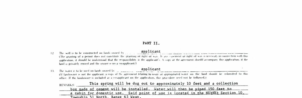
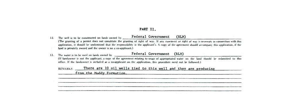
22 CHAPTER III. INSTRUCTIONS FOR PREPARING GROUND WATER FORMS Section 1. General Requirements for All Forms. All ground water forms become permanent records in the State Engineer's Office. Forms should be typed or lettered neatly with black ink. Forms should not be folded nor should they be defaced by crossing out or erasing printed matter. A copy of the approved permit will be returned routinely and a copy of all other forms will be returned to the applicant (permittee) or his agent, if requested in writing, after approval. Examples of the completed forms described hereafter are shown in Chapter IV. Section 2. Application for Permit to Appropriate Ground Water, (Form U.W. 5). An application for a permit to construct a well or other ground water diversion facility, must be submitted on Form U.W. 5. The Temporary Filing No., Permit No., Water Division No., District, and U.W. District will be entered when the form is processed in the State Engineer's Office. The remainder of the form should be completed by the applicant as follows: a. NAME AND NUMBER OF WELL --A short, distinctive name and number must be assigned to the well or other facility; for example: "Smith No. 1". b. ITEM 1 -- "Name of applicant(s) Include all parties having an interest in the application. All parties designated as landowners under Items 10 and 11, must be shown as co-applicants, or an easement or right-of-way agreement must be submitted with the application. (1) If the well is to be located on State Lands or if the lands proposed to be irrigated, or on which other beneficial use of water is to be made are State Lands, the State Board of Land Commissioners, State Capitol Building, Cheyenne, Wyoming, 82002, must be named as co-applicant. c. ITEM 2 -- Address of applicant(s) Give the respective mailing address of each applicant. d. ITEM 3 -- "Name & address of agent to receive correspondence and notices If the applicant is a company, corporation, agency, or municipality, or if several parties are named as co-applicants, one person should be designated as agent to receive correspondence. e. ITEM 4 -- "Use to which the water will be applied Mark the use or uses to which the water will be applied. (1) Irrigation use is the irrigation of any lands for agricultural purposes not covered by the definition of domestic use. (2) Municipal use is ground water used within a municipality
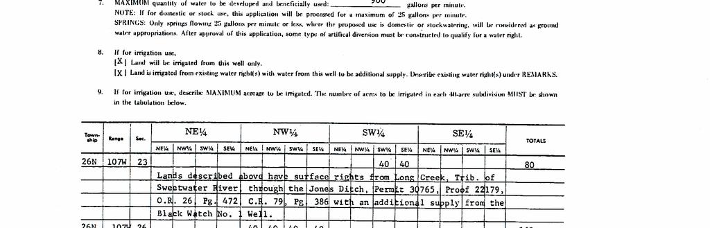
23 (Ground water provided to non-municipal subdivisions, trailer courts, etc., from private wells is not considered to be municipal use.) (3) Industrial use includes ground water used in oil field secondary recovery operations, industrial processing and mining. (4) Domestic use includes household use and the watering of lawns and gardens for noncommercial family use where the area to be irrigated does not exceed one (1) acre. A well may supply water to more than one, single family dwelling and still be considered a domestic use provided that: (a) The yield of the well does not exceed twenty-five (25) gallons per minute; (b) The total area of lawns and gardens to be watered does not exceed one (1) acre in areal extent; water; endeavor. (c) No charge, hidden or otherwise, is levied for the use of the (d) The water is not used in conjunction with a commercial (5) Stock watering is the normal watering of livestock. If feedlot operations are involved, the use should be designated as Miscellaneous" and then described in detail in the application. (6) Miscellaneous uses consist of any other ground water uses not previously described. This would include, but is not limited to, use of water for trailer courts, campgrounds, churchs, schools, temporary drilling or other temporary industrial purposes, apartment houses, automobile service stations, motels and subdivision developments with a common well. NOTE: If the use is described as Miscellaneous", the use must be described completely and accurately. (Any use not described at the time of filing will be assigned a new date of priority when the adjudication field inspection is made.) f. ITEM 5 -- Location of the well: Name the county in which the well is to be located. Designate the 40-acre subdivision or lot in which the well will be located, and the section, township and range. If the well is to be in a city, town, or platted subdivision, give the lot and block numbers, the name of the subdivision and its location. An example is Lot 9, Block 6, of the North Hills Subdivision, of Laramie County, NE ¼ NE ¼ Section 23, T.18N., R. 69W., of the 6 th P.M., Wyoming. NOTE: A well cannot be located outside the 40-acre tract specified in the application without prior approval by the State Engineer. g. ITEM 6 -- Estimated depth of the well is. Complete
24 the blank space to show approximate planned depth. h. ITEM 7 -- MAXIMUM quantity of water to be developed and beneficially used: -- Estimate the maximum amount of water that could be used. (1) The actual amount, determined after the well has been drilled and tested, must be equal to or less than the amount listed in Item 7. The actual amount will be reported on the Statement of Completion and Description of Well form. If the amount of water to be used exceeds the amount listed in Item 7 of the application, an enlargement application must be filed and approved before the additional water can be used. (2) If the application is for domestic and/or stock use, the maximum amount allowed by statute is 25 gallons per minute. (3) Only springs flowing 25 gallons per minute or less, where the proposed use is domestic or stockwatering, will be considered as ground water appropriations. i. ITEM 8 -- "If for irrigation use,. -- The appropriate box must be checked. (1) If the land will be irrigated only from the well described in this application, no further notation is needed. (2) If the land has existing water rights, these rights should be described under REMARKS. j. ITEM 9 -- If for irrigation use, describe MAXIMUM acreage to be irrigated. -- Describe the number of acres to be irrigated in each 40-acre subdivision. If the actual acreage irrigated when the well is put in production exceeds the amount shown in Item 9 of the application, an enlargement application must be approved before the additional acreage can be irrigated. Designate ownership of land; federal, State, or private. If private, give names of owners. (1) If the lands are owned by more than one party, indicate which lands are owned by each individual. (2) If part of the lands are owned by the State and/or federal Government, indicate which lands are owned by the applicant or applicants and which are administered by governmental agencies. k. ITEM 10 --This item is self-explanatory. 1. ITEM The type of irrigation-sprinkler, flood, etc., is to be described. m. ITEMS 12 and 13 These items are self-explanatory. Any unusual situation must be explained under REMARKS
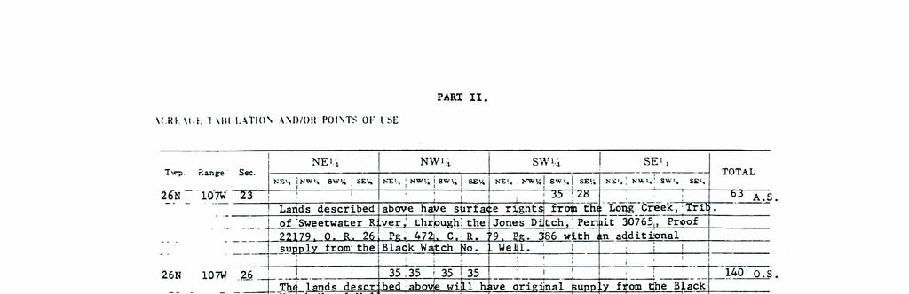
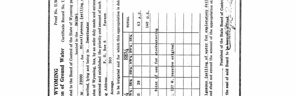
25 n. REMARKS --This space is provided for any statement or unusual circumstances peculiar to the application, or if a more complete explanation is needed for certain items. Details of industrial or any other uses should be explained in this section. Water rights or reservoirs that will be used in conjunction with this new ground water supply, if any, must be listed here also. Details of the construction used to develop a spring must be listed here. o. THE LEGALLY REQUIRED FILING FEE MUST ACCOMPANY THIS APPLICATION --A Two Dollar ($2.00) filing fee is required for each application. An application cannot be accepted for filing unless it is accompanied by this fee. p. SIGNATURE --The application form must be signed and dated. Only an applicant or his agent may sign the form. If the well is owned by more than one individual, only one need sign. If a company, corporation, agency, or municipality, is named as applicant, a designated official of the organization must sign. The official's title or agent's title should be noted behind or under the signature. Section 3. Statement of Completion and Description of Well. (Form U.W. 6). Form U.W. 6, "Statement of Completion and Description of Well", is required by law to be submitted within 30 days after completion of the well, including pump or (in the case of a flowing artesian well) control valve. Most of the items are self-explanatory. The Permit No., Name of Well, Book No., Page No., and Name (s) and address (es) of the applicant (s) will be completed in the State Engineer's Office before the form is sent to the permittee. Other items should be completed as follows: a. ITEMS 1 through 3 -- These items should be shown as they are shown on the original permit unless ownership has been changed. An explanation of any ownership changes should be provided. b. ITEM 4 -- "LOCATION OF WELL" -- The location of the well within the 40-acre subdivision should agree with the original permit. If not, provide an explanation under "REMARKS". (1) If a tie to the well is available at the time the form is submitted, it should be shown under "Bearing and Distance." (2) If no tie is available, the distance, given in feet and in the cardinal directions, from the nearest corner of the public land survey should be shown on the form in the proper place. c. ITEMS 5 through 12 --These items should be completed with information provided by the well driller and pump installer. d. ITEM TABULATION -- If for irrigation, the land proposed to be irrigated should be shown. Designate ownership of land; federal, State, or private. If private, give names of owners. The tabulation should agree, basically, with the tabulation on the original permit. If
26 the use of water is other than irrigation, show the area and point (s) of use within each 40- acre subdivision. e. ITEM "PLAT" -- Accurately show the well location, point (s) of use (s), and sketch the conveyance system on the plat. Because a plat certified by a licensed engineer or land surveyor will also be required when the well is adjudicated, this plat need only be a sketch and does not need to show ties if they are not yet available. f. REMARKS -- The means of conveying water to the lands or the point or points of use, should be described under REMARKS. In addition, this space should be used to make a complete explanation of any situation that is not explainable in the main body of the form. g. ITEM "IF WELL IS TO BE ABANDONED, Items 1 through 8 and Item 12 should be completed on the form, and an explanation of why the well was abandoned should be entered under Item 15. h. SIGNATURE -- The form must be signed and dated by the owner or his agent. If the well is owned by more than one individual, only one need sign. If a company, corporation, agency, or municipality, is named as applicant, a designated official must sign. The official's title or agent's title should be noted under the signature. Section 4. Statement of Completion and Description of Well for Domestic or Stock Watering Use Only. (Form U.W. 7). The registration of a domestic or stock well completed before May 24, 1969, should be submitted on U.W. 7. If submitted for this purpose, the form must be accompanied by the legally required Two Dollar ($2.00) filing fee. This same form is also used to submit final information on domestic or stock wells completed after May 24, When the form is used for a permitted well drilled after that date, all requested information must be completed. The Permit No., Water Division No., and U.W. District will be entered in the State Engineer's Office. The remainder of the form should be completed by the applicant as follows: a. NAME OF WELL -- If the form is being used to register a well, a short, distinctive name and number must be assigned to the well; for example: "Smith No. 1". If the form is used as a Statement of Completion for a permitted well, the name and number must be identical to the name and number on the permit. b. ITEM 1 -- "Owner" -- If the land on which the well is located is owned by more than one party, all landowners must be named as co-owners. c. ITEM 2 -- "Address" -- Mailing addresses must be shown for each respective owner. d. ITEM 3 -- Agent to receive correspondence. -- If several parties are named as owners, one party must be designated as agent to receive correspondence
27 e. ITEMS 4 through 7-- These items are self-explanatory. On wells drilled before May 24, 1969, if the driller is unknown, this fact must be noted. f. ITEM 8 -- "Means of conveyance, distance and direction to point of use Indicate distance and direction from the well to the point or points of use, and explain how the water is conveyed. If necessary, submit a diagram on a separate sheet of paper. An example of the type of entry here is: Water is conveyed to stock tank 100' SW of the well by 1 buried plastic pipe." g. ITEMS 9 through Dates are required on all wells. The dates provided should be as accurate as possible, even though they are only good estimates. (1) The priority date for wells completed prior to May 24, 1969, and registered before December 31, 1972, will revert to the date the well was completed and the water beneficially used. (A well is not considered complete until the pumping facility has been installed.) h. ITEMS 12 through If information relating to the well description, test data, pump data, casing record, and other well characteristics is not known, it should be obtained from the driller. If any of the information cannot be obtained for old wells, insert "not available" for that item, but provide a reasonable estimate whenever possible; however, Item 14 (Amount of Water being Used) must be completed for all wells. i. ITEM 18 LOG OF WELL. -- The log (description of the type of rocks encountered during drilling) should be obtained from the driller. On older wells, if a log is not available, please so indicate. Logs must be submitted for all wells drilled after May 24, j. ITEMS 19 and These items are self-explanatory. k. WELL LOCATION (on the first page of form) -- Locate the well by county, and specify the 40-acre tract, section, township and range. Mark the diagram accurately to show the well location in the small square representing 40 acres. The written description and the plat location must agree. (1) If two or more wells are located in the same 40 acres, a distance measurement between them must be shown; for example: "Smith No. 1 Well is 200' south and 100' west of Smith No. 2 Well". (2) If the well is located in a resurvey lot or tract, please give the resurvey lot or tract number and the original survey section number, township and range. This information can usually be obtained from the County Clerk's Office. (3) If the well is in a city, town, or platted subdivision, complete the information in the lower part of the WELL LOCATION block
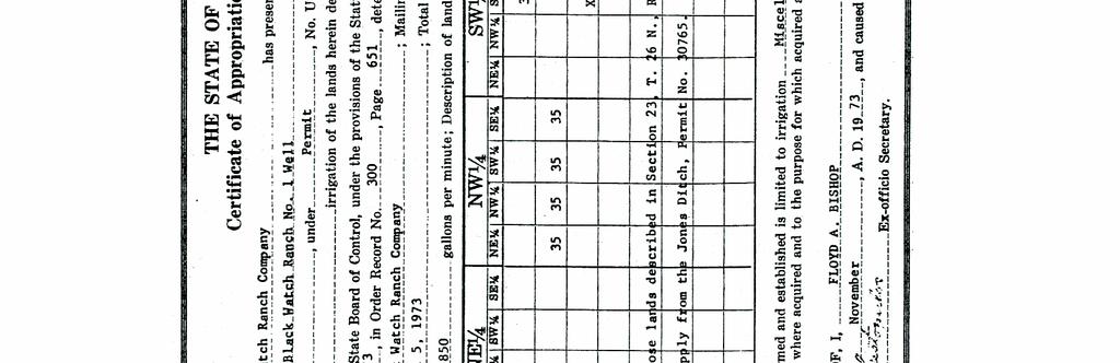
28 Give the lot and block numbers, the name of the subdivision and its location; for example: "Lot 9, Block 6 of the North Hills Subdivision of Laramie County, NE ¼ NE ¼ Section 23, T.18N., R.69W. (4) The location on a Statement of Completion for a permitted well must be identical with the location on the permit, or an explanation must be provided under "REMARKS". (5) If any of the information contained on the application form is no longer correct (such as the applicants name, address, etc.) a notation should be made in the "REMARKS" portion of the Statement of Completion providing the State Engineer's Office with the correct, current information. 1. SIGNATURE -- The application form must be signed and dated. Only an applicant or his agent may sign the form. If the well is owned by more than one individual, only one need sign. Section 5. Proof of Appropriation and Beneficial Use of Ground Water. (Form U.W. 8). The owner of the well is responsible for submitting Parts I and II of Form U.W. 8 Proof of Appropriation and Beneficial Use of Ground Water and a Certificate of Ownership. Part II consists of the linen plat prepared by a licensed engineer or land surveyor or the quadrangle map, if it is appropriate. Part III will be prepared by a State Engineer representative at the time of field inspection. On Part I, the Water Division, U.W. District, Permit No., Date of Priority, Name (s) and address (es) of the applicant (s), and Name of Well will be entered in the State Engineer's Office before the Form U.W. 8 is sent to the well owner. Other items in Part I should be completed as follows: a. ITEMS 1 and 2 -- These items should be as shown on the original permit and Form U.W. 6. If ownership has changed, an explanation should be provided. b. ITEM 3 -- "For What Purpose(s) is Water Used? Each use, and the date that the water was first used for that purpose, should be noted in the proper blank space. If the use is irrigation, give the date that irrigation was completed on all lands under the permit. c. SIGNATURE -- This form must be signed and dated by the owner or his agent. If the well is owned by more than one individual, only one need sign. If a company, corporation, agency, or municipality, is named as owner, a designated official must sign. The official's title or agent's title should be noted under the signature. d. PART II -- Part II of Form U.W. 8 is a linen plat or in some instances, a quadrangle map, which has been certified by a licensed professional engineer or land surveyor. Instructions for preparing the linen plat or quadrangle map and examples are given in Chapters V and VI of this Manual
29 CHAPTER IV. SAMPLE FORMATS The following chapter shows sample formats of all the forms dealing with obtaining a ground water right with the State Engineer's Office. All formats shown have been explained in detail in previous chapters
30 - 24 -
31 - 25 -
32 - 26 -
33 - 27 -
34 - 28 -
35 - 29 -
36 - 30 -
37 - 31 -
38 - 32 -
39 - 33 -
40 - 34 -
41 - 35 -
42 - 36 -
43 - 37 -
44 - 38 -
45 - 39 -
46 - 40 -
47 - 41 -
48 - 42 -
49 - 43 -
50 ASSIGNMENT OF PERMIT FOR WELLS PART II. STATE OF WYOMING, ) SS County of Sheridan) I. (we) Mary S. & Paul N. Johnson, of the City of Sheridan, County of Sheridan, State of Wyoming, being the owner(s) (if not sole owner, state interest in permit), of the Johnson No. 1 Well under Permit No. U.W. 8000, as recorded in Book No. 63 of Wells on Page No. 187, in the office of the State Engineer of the State of Wyoming, for and in consideration of the sum of One Dollar ($1.00) and other valuable considerations, the receipt of which is hereby achnowledged, do by these presents hereby transfer and assign all my (our) right, title and interest of whatsoever nature in and to said permit and all works pertaining thereto to Frank N. Smith, of the City of Sheridan, County of Sheridan, State of Wyoming, his (their) heirs, successors or assigns, forever, Address: 1005 Fox Road Signature City: Sheridan Signed Signature State: Wyoming STATE OF WYOMING, ) SS County of Laramie On this 5 th day of April, before me personally appeared Mary S. Johnson and Paul N. Johnson to me known to be the person(s) described in and who executed the foregoing instrument, and acknowledged that (they) executed the same as his (their) free act and deed. Signature Notary Public My Commission Expires December 22,
51 TEMPORARY WATER USE AGREEMENT INSTRUCTIONS 1. This form is to be used for Agreements involving adjudicated and valid unadjudicated water rights. 2. All locations required to be given under this Agreement shall be described by legal subdivision, section, township and range. 3. The sketch map furnished should show the 1ocation of the ditch, pipeline or reservoir or well, the location of the source of supply of the appropriation involved and the location of the point of diversion, the location of the area of use, and a brief narrative giving a general description of the proposed temporary use. 4. One (1) fully executed Agreement shall be forwarded to the State Engineer's Office. Upon approval by the State Engineer a fully executed copy will be returned to the parties to the Agreement. 5. Required size of sketch map is 8½ x 11", 8½ x 14" or multiples thereof. 6. If applicable, the signatures of both husband and wife are required on the appropriation
52 WATER AGREEMENT For Temporary Use of Water THIS AGREEMENT, made and entered into this day of 19. by and between of hereinafter referred (address) to as the "User" and (water appropriator s name and address) hereinafter referred to as "Appropriator". WITNESSETH: 1. Upon receiving authority from the State Engineer, State of Wyoming, Appropriator shall deliver to the User a total amount of of water from the following described (number of gallons, acre-feet) appropriation: (Permit Number) (Name of Well, Ditch or Reservoir) (Priority) (Source of Supply) (Amount of Appropriation) (Location of Record Point of Diversion of Ditch or Outlet or Reservoir or Well under this Appropriation) (portion of this Appropriation held by Water Appropriator) (Location of User's Point of Diversion) 2. The water to be supplied by Appropriator to the User shall be supplied at a maximum rate of (gallons per minute or cubic feet per second) With total daily diversion of, (acre-feet or gallons per day) and said water shall be used for (Indicate where and for what purpose water will be used and describe method and point of withdrawal, etc.)
53 3. It is understood and agreed by the Appropriator that in order to satisfy the consumptive use-return flow formula set forth in Wyoming law, as it applies to direct flow appropriation, it will be necessary for the Appropriation to forego the use of up to double the amount of water diverted under this Agreement as specified in paragraphs 1 and 2, unless an adjustment is made in this requirement by the State Engineer. 4. Throughout the term of this Agreement the User agrees that day to day water withdrawals hereunder shall be in such nearly even quantities as possible to the end that waste thereof shall not be created either by the User or by the Appropriator. 5. The User agrees to furnish one (1) copy of a sketch map or any other map necessary for transmittal with this Agreement showing the User's proposed point of diversion, general layout of system and the proposed point of use, as well as location of the water right involved. The items to be depicted on said map shall be shown with reasonable accuracy within the proper legal subdivision, section, township and range. 6. For and in consideration of the water to be furnished under the terms of this Agreement, the User agrees that Appropriator shall receive in payment thereof cents per M gallon, the foregoing to be full consideration for this Agreement and paid or performed by the User at its sole cost and expense. 7. This Agreement shall be in existence and binding upon the parties hereto for a term of from and after the date of (length of time) approval by the State Engineer or until such time as the total amount of water contracted for has been supplied, whichever occurs first, but in no event shall exceed a period of two years from the date of approval by the State Engineer. This Agreement is made pursuant to Chapter 193, Session Laws of Wyoming, 1971, authorizing the temporary acquisition of adjudicated or valid unadjudicated water rights for highway, railroad construction or
54 repair, drilling operations or other temporary purposes by purchase, gift or lease by the User and providing for the method of said acquisition. USER: By Title APPROPRIATOR: APPROVED: State Engineer of Wyoming Date
55 - 49 -
56 CHAPTER V. MAP AND SURVEY REQUIREMENTS FOR MAPS TO ACCOMPANY PROOF OF APPROPRIATION AND BENEFICIAL USE OF GROUND WATER Section 1. Required Plats and Maps. a. Linen plats conforming to the following requirements are required as Part II of the Proof of Appropriation and Beneficial Use of Ground Water for all wells with the exception of certain wells used for miscellaneous, domestic and stock watering purposes. (See Sections 2 through 18 of this Chapter for linen plat requirements). b. The plat for wells where the use is described as miscellaneous and where the yield or flow is twenty-five (25) gallons per minute or less may be a 7 ½ minute United States Geological Survey Quadrangle map in lieu of a linen tracing provided that the U.S. Geological Quadrangle is in compliance with the following conditions: (1) The entire United States Geological Survey Quadrangle map must be submitted to the State Engineer s Office. (2) The scale on said quadrangle map must be one to twenty-four thousand. (3) An identified section corner or quarter corner must be shown on said quadrangle map along with section, township and range. (4) The section in which the well is located and the section(s) where the area(s) or point(s) of use are located must be subdivided into forty (40) acre tracts and the well location and area(s) or point(s) of use clearly labeled and described. these maps. (5) Black waterproof ink must be used for all information shown on (6) All pipelines, storage facilities, etc., must be shown. (7) Said quadrangle map showing the well location and area(s) or point(s) of use must be certified by a professional engineer or land surveyor licensed to practice within the State of Wyoming. The above requirements also apply to wells used for domestic and stock watering purposes. (See page 62 for sample quadrangle map.) Section 2. Responsibility. In all cases, the engineer or surveyor who signs an application or map will be held personally responsible for the correctness and completeness of his work, including the work done by those in his employ or under his direction
57 Section 3. Accuracy. The accuracy of measurement required on all water right surveys shall conform in general to the principles set forth in the American Congress on Surveying and Mapping publication entitled Technical Standards for Property Surveys. Measurements shall be made with instruments capable of attaining the required accuracy for the particular problem involved. The minimum accuracy of linear measurements involving ties to wells or other control points shall be 1/500, and the maximum allowable error in any tie, regardless of length, shall be 10 feet. Irrigated acreages in each subdivision should be accurate to the nearest 1/10 of an acre. Section 4. Care. Care must be taken to determine and accurately locate the irrigable land. The boundaries of irrigable land should be meandered unless they follow section lines or regular subdivision lines of a section, or unless such boundaries can be accurately defined through the use of aerial photos. Section 5. Corner Ties. The well, separator or sump must be located by course and distance from a corner of the public land survey. Section 6. Latest Accepted Survey. The engineer or surveyor should obtain full information concerning the latest accepted survey (including protractions of unsurveyed areas) of any lands involved in a water right application, petition, or proof of appropriation and beneficial use of ground water. This information should be obtained from the office of the U.S. Department of the Interior, Bureau of Land Management, P.O. Box 1828, Cheyenne, Wyoming, 82001, or from county records or other sources of information, prior to making this survey or preparing the map. Section 7. Field Notes. The State Engineer may require copies of field notes of surveys. The engineer or surveyor should keep a complete record of each survey made, including a print of the map, facts coming to his knowledge at the time, copies of all field notes, reports, and correspondence, in order that such evidence may be produced in the future if necessary. Section 8. Aerial Photographs. Map information taken from aerial photographs may be used, with discretion, to supplement field surveys, but the location of public survey boundaries, the points of diversion of ditches, wells, and the extent and area of irrigable or irrigated lands must be determined by actual field surveys. Section 9. Acceptable Materials. a. All proofs of appropriation and beneficial use of ground mater must be accompanied by maps in duplicate; one of which must be on good quality tracing linen or equivalent. Original drawings prepared on polyester base films with a minimum thickness of inch will be acceptable. This will include Estar, Cronaflex, and Mylar drafting films. Maps accompanying original applications must be neatly drawn in either black waterproof ink or acetate ink which will print clearly. Maps on which pencil, ball-point pen, or ink other than black has been used, will not
58 be acceptable. PART II. b. Maps to accompany enlargement applications or amendments of previous filings may be prepared by securing a duplicate original of the map already on file in the State Engineer s Office, and by making the necessary alterations and additions thereto. Duplicate originals, in order to be acceptable, must be on Mylar, Estar, Cronaflex, or equivalent drafting films with a matte surface designed to accept ink and with a minimum thickness of inch. c. Maps which have been folded will not be accepted. Section 10. Sizes. a. All linen plats must conform to one of the standard sizes listed. Linen plats prepared on sheets of any other size will not be accepted. If one sheet is not sufficient to show the proposed works, two or more sheets of the same size may be used. Keep all map information within the border line. b. Loose-leaf books are in use for each size given below, and all linen plats are filed flat in order to preserve the record contained on them. Linen plats must be made on sheets of the following sizes and dimensions: OVERALL DIMENSIONS MARGINS Size Length Width Binding Side Other Sides B /4 1-1/2 1/4 D 21-1/ /2 3/8 E /2 1-1/2 1/2 F /4 3/4 See pages 56 and 57 for pictorial representation of plat sizes and margin arrangements. (1) The F size sheet is very unhandy to file and to use; consequently, it is preferred that the B, D, or E size sheets be utilized if possible. The preferred plat size for ground water plats is the B size. Statutory provisions also permit the use of size A which is 8-1/2 inches wide and 11 inches long; size AA which is 8-1/2 inches wide and 14 inches long; and size C which is 22 inches wide and 36 inches long. The State Engineer s Office, however, is not equipped with books for filing these sizes; therefore, the sizes included in the above tabulation are preferred. Section 11. Arrangement. See Pages 60 through 61 for ideal arrangement of data. Attention is called to the necessity of placing the binding edge as indicated. Provide a 1" x 4" space for the State Engineer s
59 endorsement, as shown on the sample plats. Orient the plat so the meridian is parallel to the binding edge, and, if possible, so the north arrow points to the top of the plat. Section 12. Title. Always place the title in the lower right-hand corner. The title on the plat should conform with the names given in the accompanying petitions or proofs of appropriation and beneficial use of ground water. The title should include the names of all ditches, enlargements, reservoirs, pipelines, and/or wells which are directly involved in the petitions or ground water proofs. The names and addresses of the petitioners or permittees, and the scale of the plat should also be included in the title block. The permit numbers for the ground water rights involved must be shown. Section 13. Scale. Location plats and maps must be drawn to a scale of not less than 2"=1 mile. Use a large enough scale to show all of the required information clearly. Show the scale used for all plats. Section 14. Ties. a. Ties must be shown on the plat from a corner of the public land survey to the well, separator, sump or pump location where pits are involved. b. All distances must be shown in feet. Plats must be plotted to the true meridian, and bearings shown must be true bearings, reading less than 90 to the east or west from the north and south points. Section 15. Information to be Shown. a. The well must be shown in such a manner that its location stands out clearly, and the name must be shown. Sufficient detail of the conveyance system must be shown so that it is apparent as to how water will be conveyed to each subdivision. On ground water plats, it should be noted whether the system carries ground water, surface water, or both. b. Entire sections must be shown in all cases. When any part of a section is involved in an application or petition, the entire section, subdivided into forties and lots, must be shown. Where lots or tracts are shown, they must be plainly labeled on the plat, and the entire lot or tract is to be shown. Homestead entries and mineral surveys are to be related to the nearest section to indicate their position in the township. In cases where the well is located within a recorded subdivision, an insert showing the well location within the section may be added. c. Certificate of Engineer or Surveyor must be shown. An example is shown on page 54 and may be used as a general guide. d. The location and acreage of all lands being irrigated in each subdivision must be shown on ground water plats
60 hatching. PART II. (1) Such lands must be indicated on the plat by symbols or cross (2) Lands under different permits must be shown by distinctively different crosshatching or symbols. or symbols. (3) The plat must contain a legend showing the kind of cross-hatching (4) Watercoloring wrinkles the linen and therefore must not be used. (5) The lands shown on a ground water plat must be the actual acreage irrigated from the ground water source at the time of the survey. e. On ground water plats, only the actual acreage irrigated from existing surface water sources should be shown. The source of the surface water must be identified. For example: Jones Ditch conveys water from Sweetwater Creek. It is not necessary to research water right records; only to show what is actually in the field. f. For secondary recovery operations, all injection wells, distribution lines and storage facilities are to be shown. If a separator is the source of the water, a tie to the separator must be provided. Section 16. Pipelines, Gathering Systems, Etc. In situations where pipelines, gathering systems, etc., are contemplated or proposed, the State Engineer may require a plat prepared by a licensed engineer or land surveyor showing the proposed pipeline route and points of use. Section 17. Additional Required Information. Plats for Proof of Appropriation and Beneficial Use of Ground Water are also required to show the following: a. Storage facilities, if involved in the use of ground water, must be shown. Permits for sources of ground water used within the distribution system, but brought from outside the area shown on the map, must be identified by note. b. If lands are owned by more than one party, or are owned by the State or Federal Government, such ownership must be clearly shown. Roads, railroads, and other important cultural features also should be shown, where practical. c. The term supplemental supply does not apply to ground water. If more than one well irrigates the same land, or if both ground and surface water are applied to the same land, it is sufficient to reference the well names on the plat and to identify all wells in the title block. Acreage irrigated from surface water sources must be shown so as to reflect any use of surface water on the same lands covered by the ground water rights surveyed. d. A blank area, at least 4 inches wide and 2 inches deep, must
61 be left in the upper right-hand corner of the plat. Examples are shown on pages 60 and 61. This blank area, to be completed in the State Engineer s Office only, will be used to reference surface water rights as they are shown on existing records. Section 18. Sample Plats and Maps. Pages 58 through 62 contain sample plats and maps prepared in accordance with the requirements of the State Engineer s Office, and should be used as guides in the preparation of plats and maps to be filed with the Proof of Appropriation and Beneficial Use of Ground Water
62 CHAPTER VI. SAMPLE LINEN PLATS AND QUADRANGLE MAPS Section 1. Dimensions and Arrangement. Pages 58 through 60 contain sample plats and maps prepared in accordance with the requirements of the State Engineer's Office, and should be used as guides in the preparation of plats and maps to be filed with the Proofs of Appropriation and Beneficial Use of Ground Water - Form U.W. 8. Section 2. Engineer's Certificate. a. Certificate for plats and maps to accompany Proof of Appropriation and Beneficial Use of Ground Water - Form U.W. 8: CERTIFICATE OF ENGINEER OR SURVEYOR (1) All linen plats must have the following certificate: STATE OF WYOMING ) ) SS. COUNTY OF ) I, of hereby certify that this plat was made from notes taken during an actual survey made by me on, 19, (or made on, 19, under my direction by, for whose work I stand personally responsible). Such survey is accurately represented on this plat, and correctly shows the location of the well(s) and acreage under irrigation at the time of the survey (or correctly shows the location of the well(s) and point(s) of use at the time of the survey). Wyoming Registration No. (Indicate -- PE and/or LS) (Signed) (Engineer or Surveyor)
63 (2) All quadrangle maps must have the following certificate: STATE OF WYOMING ) ) SS. COUNTY OF ) CERTIFICATE OF SURVEYOR I, of hereby certify that this map was made by on, 19, and correctly shows the location of the well(s) and point(s) and area(s) of use at the time this map was prepared. Wyoming PE or LS No. (Signed) (Engineer or Surveyor) NOTE: All certificates should also credit the use of information obtained from other sources where other sources are used. Care should be taken that certification indicates the source of all information shown on the map
64 - 58 -
65 - 59 -
66 - 60 -
67 - 61 -
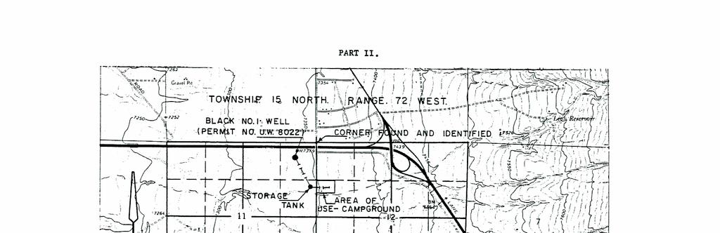
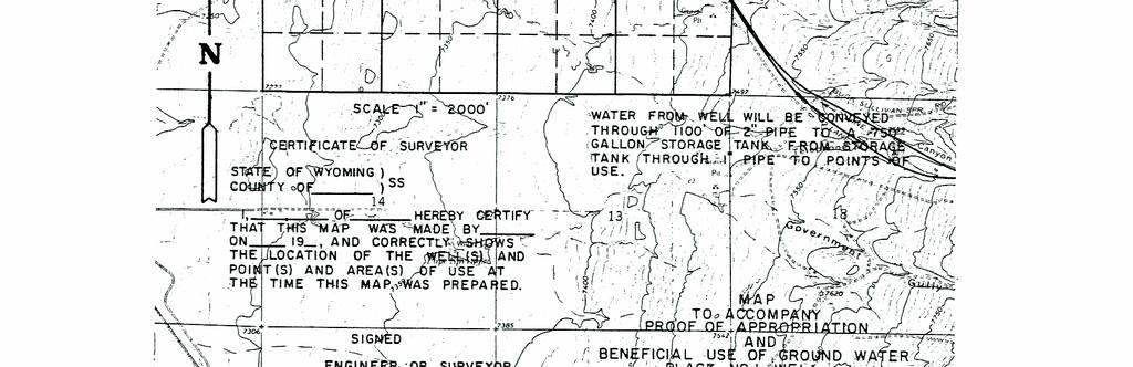
68 - 62 -
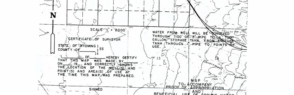
69 - 63 -
CHAPTER IV ADJUDICATION OF PROOFS
 ADJUDICATION OF PROOFS Section 1. Surface Water Proofs. a. The requirements for the submission of, advertising, holding open for inspection, opportunity of contest, and allowance of proofs of appropriation
Engineer, State. General Agency, Board or Commission Rules. Chapter 1: Fees. Wyoming Administrative Rules. Effective Date: 07/13/2017.
 Engineer, State Wyoming Administrative Rules General Agency, Board or Commission Rules Chapter 1: Fees Effective Date: Rule Type: Reference Number: 07/13/2017 Emergency Rules & Regulations 037.0003.1.07132017
Change in Use and/or Change in Place of Use Procedure to change use or place of use.
 Types of Petitions Appeal from Endorsement of the State Engineer 41-4-514. Petition for amendment of permits; petition for amended certificate of appropriation; hearings on petition; notice; costs. The
Panhandle Groundwater Conservation District Rules Approved March 18, 2014
 Panhandle Groundwater Conservation District Rules Approved March 18, 2014 PO Box 637 White Deer, TX 79097 806-883-2501 www.pgcd.us Rules of Panhandle Groundwater Conservation District Preamble The purpose
SUPREME COURT OF THE UNITED STATES
 OCTOBER TERM, 2001 1 Decree SUPREME COURT OF THE UNITED STATES No. 108, Orig. STATE OF NEBRASKA, PLAINTIFF v. STATES OF WYOMING AND COLORADO ON PETITION FOR ORDER ENFORCING DECREE AND FOR INJUNCTIVE RELIEF
SECTION 2. BOARD: RULE 2.1 ELECTION OF DIRECTORS AND TAXING AUTHORITY RULE 2.2 BOARD STRUCTURE, OFFICERS... 11
 PREAMBLE The rules of the Middle Trinity Groundwater Conservation District were originally adopted by the Board of Directors on May 11 th, 2004, at a duly posted public meeting in compliance with the Texas
ALABAMA PUBLIC SERVICE COMMISSION ADMINISTRATIVE CODE CHAPTER 770-X-9 WASTEWATER MANAGEMENT ENTITY RULES TABLE OF CONTENTS
 ALABAMA PUBLIC SERVICE COMMISSION ADMINISTRATIVE CODE CHAPTER 770-X-9 WASTEWATER MANAGEMENT ENTITY RULES TABLE OF CONTENTS 770-X-9-.01 770-X-9-.02 770-X-9-.03 770-X-9-.04 770-X-9-.05 770-X-9-.06 770-X-9-.07
Idaho Water Law: Water Rights Primer & Definitions. A. What is a Water Right?
 Idaho Water Law: Water Rights Primer & Definitions DISCLAIMER: This information was created by and is attributable to IDWR. It is provided through the Law Office of Arthur B. for your adjudication circumstances
GROUND WATER RUNOFF PROGRAM RULES AND REGULATIONS. Originally Adopted: January 1978
 GROUND WATER RUNOFF PROGRAM RULES AND REGULATIONS SOUTH PLATTE NATURAL RESOURCES DISTRICT 551 Parkland Drive P.O. Box 294 Sidney, Nebraska 69162 Telephone Number: 308-254-2377 Fax Number: 308-254-2783
Application For Rezoning
 Application For Rezoning Thank you for your interest in Jackson County, Georgia. This packet includes the necessary documents for Rezoning Requests to be heard by the Jackson County Planning Commission
ONLINE VERSION STATE/FEDERAL/FEE EXPLORATORY UNIT UNIT AGREEMENT FOR THE DEVELOPMENT AND OPERATION OF THE NO.
 ONLINE VERSION STATE/FEDERAL/FEE EXPLORATORY UNIT UNIT AGREEMENT FOR THE DEVELOPMENT AND OPERATION OF THE UNIT AREA County(ies) NEW MEXICO NO. Revised web version December 2014 1 ONLINE VERSION UNIT AGREEMENT
This document is available at WATER RESOURCES MANAGEMENT ACT NO. 9 OF 2002
 Water Resources Management Act 2002 Commencement: 10 March 2003 This document is available at www.ielrc.org/content/e0217.pdf REPUBLIC OF VANUATU WATER RESOURCES MANAGEMENT ACT NO. 9 OF 2002 Arrangement
ELKHART COUNTY PLAN COMMISSION Rules of Procedure
 ELKHART COUNTY PLAN COMMISSION Rules of Procedure Article 1 Authority, Duties and Jurisdiction 1.01 Authority 1.02 Duties The Elkhart County Plan Commission (hereinafter called Commission ) exists as an
Division 1 Preliminary
 Division 1 Preliminary s. 151 Preliminary Division 1 s. 151 Division 1 Preliminary Subdivision 1 Interpretation 151. Terms used in this Part and Part 10 (1) In this Part and Part 10 acquiring authority,
BEFORE THE CORPORATION COMMISSION OF THE STATE OF OKLAHOMA STAFF'S REVISED PROPOSED RULES. March 6,2013 TITLE 165. CORPORATION COMMISSION
 BEFORE THE CORPORATION COMMISSION OF THE STATE OF OKLAHOMA IN THE MATTER OF A PERMANENT ) RULEMAKING OF THE OKLAHOMA ) CORPORATION COMMISSION ) CAUSE RM NO. 201300002 AMENDING OAC 165:5, RULES OF ) PRACTICE
The Crown Minerals Act
 1 The Crown Minerals Act being Chapter C-50.2 of the Statutes of Saskatchewan, 1984-85- 86 (effective July 1, 1985) as amended by the Statutes of Saskatchewan, 1988-89, c.42; 1989-90, c.54; 1990-91, c.13;
Rules of the Rolling Plains Groundwater Conservation District
 Rules of the Rolling Plains Groundwater Conservation District ORIGINALLY ADOPTED: January 18, 2001 REVISED: July 19, 2001 REVISED: December 19, 2002 REVISED: April 17, 2003 REVISED: September 18, 2003
RAILROAD COMMISSION OF TEXAS OFFICE OF GENERAL COUNSEL OIL AND GAS SECTION
 RAILROAD COMMISSION OF TEXAS OFFICE OF GENERAL COUNSEL OIL AND GAS SECTION RULE 37/38 CASE NO. 0210331; APPLICATION OF RIO PETROLEUM, INC. FOR A RULE 37 AND RULE 38 EXCEPTION TO DRILL WELL NO. 1, POWELL
November 29, 2018 DRAFT Subject to notice and hearing RULES OF THE REEVES COUNTY GROUNDWATER CONSERVATION DISTRICT
 November 29, 2018 DRAFT Subject to notice and hearing RULES OF THE REEVES COUNTY GROUNDWATER CONSERVATION DISTRICT Amended: Effective Date:, 2019 TABLE OF CONTENTS INTRODUCTION...1 RULE 1. DEFINITIONS
THE WATER UTILIZATION (CONTROL AND REGULATION) ACT, 1974 PART I
 ACT, 1974 PART I") THE WATER UTILIZATION (CONTROL AND REGULATION) ACT, ARRANGEMENT OF SECTIONS Section Title PART I PRELIMINARY 1. Short title and commencement. 2. Interpretation. 3. Application of Act to the Government,
THE WATER UTILIZATION (CONTROL AND REGULATION) ACT, ARRANGEMENT OF SECTIONS Section Title PART I PRELIMINARY 1. Short title and commencement. 2. Interpretation. 3. Application of Act to the Government,
Article VII - Administration and Enactment
 Section 700 '700.1 PERMITS Building/Zoning Permits: Where required by the Penn Township Building Permit Ordinance for the erection, enlargement, repair, alteration, moving or demolition of any structure,
ARTICLE 10: ADMINISTRATION AND ENFORCEMENT OF ORDINANCE
 ARTICLE 10: ADMINISTRATION AND ENFORCEMENT OF ORDINANCE Section 10.0 - Zoning Administrator A. The provision of this Ordinance shall be administered in accordance with the Michigan Zoning Enabling Act,
SANTA RITA UNDERGROUND WATER CONSERVATION DISTRICT RULES
 SANTA RITA UNDERGROUND WATER CONSERVATION DISTRICT RULES AMENDED MAY 24, 2016 Table of Contents Page RULE 1 DEFINITIONS... 2 RULE 1A DRILLING AND OPERATING PERMITS REQUIRED... 9 RULE 1B PERMIT EXEMPTIONS...
ARTICLE XIV. - WATER DEPARTMENT
 Section 1400. - ESTABLISHMENT OF WATER DEPARTMENT. Sec. 1401. - RULES OF PROCEDURE. Sec. 1402. - WATER RIGHTS. Sec. 1403. - POWERS AND DUTIES. Sec. 1404. - DEMANDS AGAINST WATER DEPARTMENT FUNDS. Sec.
ACT 522 Water Resources Commission Act, 1996 THE FIVE HUNDRED AND TWENTY-SECOND ACT OF THE PARLIAMENT OF THE REPUBLIC 0F GHANA ENTITLED
 ACT 522 Water Resources Commission Act, 1996 THE FIVE HUNDRED AND TWENTY-SECOND ACT OF THE PARLIAMENT OF THE REPUBLIC 0F GHANA ENTITLED WATER RESOURCES COMMISSION ACT, 1996 AN ACT to establish a Water
McMullen Groundwater Conservation District. APPROVED September 26, 2012
 McMullen Groundwater Conservation District APPROVED September 26, 2012 MCMULLEN GROUNDWATER CONSERVATION DISTRICT RULES RULE 1 DEFINITIONS... 1 RULE 2 WASTE PROHIBITED... 4 RULE 3 WELL REGISTRATION...
Referred to Committee on Natural Resources, Agriculture, and Mining. SUMMARY Revises provisions governing the appropriation of water.
 ASSEMBLY BILL NO. 0 COMMITTEE ON NATURAL RESOURCES, AGRICULTURE, AND MINING (ON BEHALF OF THE DIVISION OF WATER RESOURCES OF THE STATE DEPARTMENT OF CONSERVATION AND NATURAL RESOURCES) PREFILED NOVEMBER,
Regional Wastewater Treatment: Sanitary Districts and Cooperative Agreements
 Regional Wastewater Treatment: Sanitary Districts and Cooperative Agreements Water Quality/Wastewater Treatment Plants #3.04 April 2013 Contents Sanitary districts... Page 1 Authority of cities and counties...
CHAPTER 442A SANITARY DISTRICTS
 1 MINNESOTA STATUTES 2015 442A.01 CHAPTER 442A SANITARY DISTRICTS 442A.01 DEFINITIONS. 442A.015 APPLICABILITY. 442A.02 SANITARY DISTRICTS; PROCEDURES AND AUTHORITY. 442A.03 FILING OF MAPS IN SANITARY DISTRICT
SECTION 9. FEEDLOT REGULATIONS
 SECTION 9. FEEDLOT REGULATIONS Subsection 9.1: Statutory Authorization, Policy & General Provisions A. Statutory Authorization. The Swift County Feedlot Regulations are adopted pursuant to the authorization
^ with the Board and that the Board has full jurisdiction of the
 .r BEFORE THE STATE OIL AND GAS BOARD OF MISSISSIPPI RE: PETITION OF FOUR MILE CREEK GAS STORAGE, LLC, FOR AUTHORITY TO USE DEPLETED GAS RESERVOIRS OF FOUR MILE CREEK FIELD, MONROE COUNTY, MISSISSIPPI,
UPPER CHICHESTER TOWNSHIP ZONING HEARING BOARD P.O. BOX 2187 UPPER CHICHESTER, PA (610)
") UPPER CHICHESTER TOWNSHIP ZONING HEARING BOARD P.O. BOX 2187 UPPER CHICHESTER, PA 19061 (610) 485-5719 INSTRUCTIONS TO APPLICANTS A. General Instructions Applicants who have a request to make of the Zoning
UPPER CHICHESTER TOWNSHIP ZONING HEARING BOARD P.O. BOX 2187 UPPER CHICHESTER, PA 19061 (610) 485-5719 INSTRUCTIONS TO APPLICANTS A. General Instructions Applicants who have a request to make of the Zoning
APPLICATION FOR PIPELINE PUBLIC ROAD CROSSING PERMIT
 THE STATE OF TEXAS COUNTY OF BURLESON APPLICATION FOR PIPELINE PUBLIC ROAD CROSSING PERMIT TO: THE COMMISSIONERS COURT OF BURLESON COUNTY, TEXAS GENTLEMEN: ON THIS THE day of, 20, the undersigned, hereinafter,
Chapter 132 STREETS AND SIDEWALKS. ARTICLE I Street Openings and Excavations
 Chapter 132 STREETS AND SIDEWALKS ARTICLE I Street Openings and Excavations 132-1. Definitions. 132-2. Permits required. 132-3. Permits not transferable. 132-4. Application for permit; fee. 132-5. Conditions
CITY OF GOODYEAR ADMINISTRATIVE PROCESS MANUAL (APM) TABLE OF CONTENTS
 TABLE OF CONTENTS") CITY OF GOODYEAR ADMINISTRATIVE PROCESS MANUAL (APM) TABLE OF CONTENTS 1.0 INTRODUCTION 1.1 Introduction and Universal Provisions 1.2 Definitions 2.0 DEVELOPMENT SERVICES PROCESSES 2.1 Annexation 2.2 Assisted
CITY OF GOODYEAR ADMINISTRATIVE PROCESS MANUAL (APM) TABLE OF CONTENTS 1.0 INTRODUCTION 1.1 Introduction and Universal Provisions 1.2 Definitions 2.0 DEVELOPMENT SERVICES PROCESSES 2.1 Annexation 2.2 Assisted
CHAPTER IV SMALL ON-SITE WASTEWATER SYSTEMS. 4.1 Purpose: The regulations in this chapter are enacted for the purpose of regulating
 CHAPTER IV SMALL ON-SITE WASTEWATER SYSTEMS 4.1 Purpose: The regulations in this chapter are enacted for the purpose of regulating the design, construction and modification of small on-site wastewater
South Dakota Department of Agriculture
 South Dakota Department of Agriculture 12/12/2011 South Dakota Department of Agriculture Establishing and Combining Watershed Districts Presenter: A. Blair Dunn General Counsel & Director of Agricultural
CHAPTER 2 NOXIOUS WEEDS
 4-2-1 4-2-2 CHAPTER 2 NOXIOUS WEEDS SECTION: 4-2-1: Purpose 4-2-2: Duty To Control 4-2-3: Definitions 4-2-4: Enforcement 4-2-5: Notice Requirements 4-2-6: State And Federal Land 4-2-7: Costs 4-2-8: Prevention
The Planning and Development Act
 The Planning and Development Act UNEDITED being Chapter P-13 of The Revised Statutes of Saskatchewan, 1978 (effective February 26, 1979). NOTE: This consolidation is not official. Amendments have been
GEOTHERMAL RESOURCES ACT
 LAWS OF KENYA GEOTHERMAL RESOURCES ACT CHAPTER 314A Revised Edition 2012 [1982] Published by the National Council for Law Reporting with the Authority of the Attorney-General www.kenyalaw.org [Rev. 2012]
Overview. Types of Water. Lost Pines Groundwater Conservation District Workshop - May 19,
 APPLICATION OF CHAPTER 36 AND THE DISTRICT S RULES AND MANAGEMENT PLAN TO THE OPERATION AND MANAGEMENT OF THE DISTRICT LOST PINES GROUNDWATER CONSERVATION DISTRICT MAY 19, 2018 WORKSHOP BY NATASHA J. MARTIN
Central Texas Groundwater Conservation District
 Central Texas Groundwater Conservation District DISTRICT RULES As Revised January 29, 2018 CTGCD Rules As Revised January 29, 2018 Central Texas Groundwater Conservation District District Rules REVISION
Oil, Gas, & Minerals Division Revised March 2017 COMMUNITIZATION AGREEMENT
 NM State Land Office Oil, Gas, & Minerals Division STATE/STATE OR STATE/FEE Revised March 2017 COMMUNITIZATION AGREEMENT ONLINE Version KNOW ALL MEN BY THESE PRESENTS: Well Name: STATE OF NEW MEXICO )
TITLE 64 LEGISLATIVE RULE DEPARTMENT OF HEALTH SERIES 19 WATER WELL REGULATIONS
 TITLE 64 LEGISLATIVE RULE DEPARTMENT OF HEALTH SERIES 19 WATER WELL REGULATIONS '64-19-1. General. 1.1. Scope. -- This legislative rule establishes the certification of water well drillers and the issuance
HOUSE BILL NO. HB0025. Sponsored by: Joint Minerals, Business & Economic Development Interim Committee A BILL. for
 0 STATE OF WYOMING LSO-0 HOUSE BILL NO. HB00 Limited and small mines-amendments-. Sponsored by: Joint Minerals, Business & Economic Development Interim Committee A BILL for AN ACT relating to environmental
The Kerala Survey and Boundaries Act, Amendments appended: 23 of 1972, 22 of 1994, 29 of 2007
 The Kerala Survey and Boundaries Act, 1961 Act 37 of 1961 Keyword(s): Holder of any Landed Land, Survey, Survey Mark Amendments appended: 23 of 1972, 22 of 1994, 29 of 2007 DISCLAIMER: This document is
COAL CONSERVATION ACT
 Province of Alberta COAL CONSERVATION ACT Revised Statutes of Alberta 2000 Current as of June 17, 2013 Office Consolidation Published by Alberta Queen s Printer Alberta Queen s Printer 7 th Floor, Park
MISSISSIPPI LEGISLATURE REGULAR SESSION 2013 COMMITTEE SUBSTITUTE FOR HOUSE BILL NO. 719
 MISSISSIPPI LEGISLATURE REGULAR SESSION 2013 By: Representative Mims To: Public Health and Human Services COMMITTEE SUBSTITUTE FOR HOUSE BILL NO. 719 AN ACT TO REENACT SECTIONS 41-67-1 THROUGH 41-67-29
The Mineral Resources Act
 The Mineral Resources Act UNEDITED being Chapter 50 of The Revised Statutes of Saskatchewan, 1965 (effective February 7, 1966). NOTE: This consolidation is not official. Amendments have been incorporated
SYNOPSIS: Under existing law, local governing bodies with approved solid waste
 1 1 1 1 1 1 1 1 0 1 SYNOPSIS: Under existing law, local governing bodies with approved solid waste management plans are allowed 0 days from the submission of an application for the siting of a solid waste
NON-ATTORNEY S GUIDE TO COLORADO WATER COURTS
 NON-ATTORNEY S GUIDE TO COLORADO WATER COURTS INTRODUCTION The purpose of this guide is to assist you through the most common water court processes. These processes include applying for a water right and
CHAPTER 29 DRAINAGE AND DITCHES
 CHAPTER 29 DRAINAGE AND DITCHES Latest Revision 1994 29.01 GENERAL INFORMATION Ohio's drainage laws are very broad in nature and detailed in the procedure necessary to bring a project to completion. Ohio
CONTRACT FOR SALE AND PURCHASE
 CONTRACT FOR SALE AND PURCHASE THIS CONTRACT FOR SALE AND PURCHASE ("Agreement") is entered into on this day of, 20, by and between BROWARD COUNTY, a political subdivision of the State of Florida ("COUNTY''
ENVIRONMENTAL CODE SUMNER COUNTY, KANSAS CHAPTER 2 ON-SITE WASTEWATER MANAGEMENT
 ENVIRONMENTAL CODE SUMNER COUNTY, KANSAS CHAPTER 1 ADMINISTRATIVE PROCEDURES CHAPTER 2 ON-SITE WASTEWATER MANAGEMENT CHAPTER 3 NONPUBLIC WATER SUPPLIES Minimum Separation Distance Between Nonpublic Water
ROADS. Scioto County Engineer Darren C. LeBrun, PE, PS INFORMATION COMPILED FROM OHIO REVISED CODE CHAPTER 5553
 Scioto County Engineer Darren C. LeBrun, PE, PS Scioto County Courthouse Room 401 602 Seventh Street Portsmouth, OH 45662 Phone Number: 740-355-8265 Scioto County Highway Garage 56 State Route 728, P.O.
MEMO INFORMATION, MINERALS PROGRAM. DATE: October 2, 2001 Revised October 19, 2001, August 2, 2004, and January 12, 2006
 MEMO INFORMATION, MINERALS PROGRAM TO: FROM: Whom It May Concern The Division of Reclamation, Mining and Safety DATE: October 2, 2001 Revised October 19, 2001, August 2, 2004, and January 12, 2006 RE:
A BILL. To enhance the management and disposal of spent nuclear fuel and high-level radioactive
 A BILL To enhance the management and disposal of spent nuclear fuel and high-level radioactive waste, to assure protection of public health and safety, to ensure the territorial integrity and security
GENERAL ASSEMBLY OF NORTH CAROLINA SESSION 2013 H 3 HOUSE BILL 488 Committee Substitute Favorable 4/9/13 Third Edition Engrossed 4/11/13
 GENERAL ASSEMBLY OF NORTH CAROLINA SESSION 0 H HOUSE BILL Committee Substitute Favorable // Third Edition Engrossed // Short Title: Regionalization of Public Utilities. (Public) Sponsors: Referred to:
MOVABLE PROPERTY SECURITY RIGHTS ACT
 LAWS OF KENYA MOVABLE PROPERTY SECURITY RIGHTS ACT NO 13 OF 2017 Revised Edition 2017 Published by the National Council for Law Reporting with the Authority of the Attorney-General wwwkenyalaworg [Rev
INSTRUCTIONS TO TENDERERS
 INSTRUCTIONS TO TENDERERS BEAVER COUNTY 2018 YEAR GRAVEL HAUL CONTRACT INSTRUCTIONS TO TENDERERS 1. BACKGROUND 1.1 Beaver County is seeking a tender for (the Work ), as more particularly set out in Schedule
A Practitioner s Guide to Instream Flow Transactions in California
 A Practitioner s Guide to Instream Flow Transactions in California Appendix A Forbearance Agreement Examples Agreement for the Forbearance of Water for Fisheries Enhancement in the ---------- River System,
NC General Statutes - Chapter 156 Article 7 1
 Article 7. Construction of Improvement. 156-83. Superintendent of construction. The board of drainage commissioners shall appoint a competent drainage engineer of good repute as superintendent of construction.
LINKAGE TO STRATEGIC PLAN, POLICY, STATUTE OR GUIDING PRINCIPLE:
 CONTACT: Dennis Rule Suzanne Ticknor 623-869-2667 623-869-2410 drule@cap-az.com sticknor@cap-az.com MEETING DATE: March 7, 2013 Agenda Number 2.d. AGENDA ITEM: Approval of Water Availability Status Contract
CHAPTER 3 - TOHONO O ODHAM NATION WATER CODE
 TITLE 25 - WATER CHAPTER 3 - TOHONO O ODHAM NATION WATER CODE Legislative History: The Tohono O odham Nation Water Code was enacted and codified by Resolution No. 11-198 as Tohono O'odham Code Title 25,
Expedited Type 2 Annexations: Petitions By All Property Owners With or Without Consent of Municipality & Township(s)
") CHAPTER5 Expedited Type 2 Annexations: Petitions By All Property Owners With or Without Consent of Municipality & Township(s) General Comments Chapter 5 will deal with Expedited Type 2 Annexations those
CHAPTER5 Expedited Type 2 Annexations: Petitions By All Property Owners With or Without Consent of Municipality & Township(s) General Comments Chapter 5 will deal with Expedited Type 2 Annexations those
RAILROAD COMMISSION OF TEXAS OIL AND GAS DIVISION FINAL ORDER FINDINGS OF FACT
 RAILROAD COMMISSION OF TEXAS OIL AND GAS DIVISION RULE 37 CASE NO. 0220725 DISTRICT 6E APPLICATION OF LARRY V. TATE OPERATING, INC. FOR AN EXCEPTION TO STATEWIDE RULE 37 TO RE-ENTER WELL NO. 2, ELDER BROS.
2015 California Public Resource Code Division 9
 2015 California Public Resource Code Governing Legislation of California Resource Conservation Districts Distributed By: Department of Conservation Division of Land Resource Protection RCD Assistance Program
TOWN OF HERNDON, VIRGINIA ORDINANCE DECEMBER 13, 2016
 TOWN OF HERNDON, VIRGINIA ORDINANCE DECEMBER 13, 2016 Ordinance-to amend and reenact Chapter 30 (Finance & Taxation), Article VIII (Fiscal Procedures), Division 2 (Procurement), of the Herndon Town Code,
RAILROAD COMMISSION OF TEXAS LEGAL DIVISION OIL AND GAS SECTION FINAL ORDER FINDINGS OF FACT
 RAILROAD COMMISSION OF TEXAS LEGAL DIVISION OIL AND GAS SECTION RULE 37 CASE NO. 0201412 RE: APPLICATION OF OXY USA, INC. DISTRICT 6E FOR AN EXCEPTION TO STATEWIDE RULE 37 TO DRILL ITS WELL NO. 8, WHATLEY
SUGGESTIONS FOR OPERATORS OPTIONAL PROCEDURE FOR SPACING-RELATED APPLICATIONS OCC-OAC 165:
 FOR SPACING-RELATED APPLICATIONS COMPILED BY THE STAFF OF THE OKLAHOMA CORPORATION COMMISSION OIL AND GAS CONSERVATION DIVISION AND THE OFFICE OF GENERAL COUNSEL TABLE OF CONTENTS INTRODUCTION...3 STEP-BY-STEP
TOWN OF RAYNHAM BOARD OF HEALTH MINIMUM SANITATION STANDARDS FOR PRIVATE AND SEMI-PUBLIC WATER SUPPLY
 TOWN OF RAYNHAM BOARD OF HEALTH MINIMUM SANITATION STANDARDS FOR PRIVATE AND SEMI-PUBLIC WATER SUPPLY Purpose & Scope: The purpose of these regulations is to set forth standards where the Raynham Board
Title 20 ANNEXATIONS. Chapters: ANNEXATIONS LOT BOUNDARIES. Page 1 of 14
 Title 20 ANNEXATIONS Chapters: 20.04 ANNEXATIONS 20.08 LOT BOUNDARIES Page 1 of 14 Chapter 20.04 ANNEXATIONS Sections: 20.04.009 Article I. General Provisions 20.04.010 Title 20.04.020 Authorization 20.04.030
BEE GROUNDWATER CONSERVATION DISTRICT RULES
 BEE GROUNDWATER CONSERVATION DISTRICT RULES AMENDED OCTOBER 18, 2012 Table of Contents RULE 1 DEFINITIONS... 1 RULE 2 WASTE PROHIBITED... 5 RULE 3 WELL REGISTRATION... 5 RULE 4 FEES AND DEPOSITS... 6 RULE
AN ACT. The General Assembly of the Commonwealth of Pennsylvania hereby enacts as follows:
 COAL REFUSE DISPOSAL CONTROL ACT - ESTABLISHMENT OF COAL BED METHANE REVIEW BOARD AND DECLARATION OF POLICY Act of Feb. 1, 2010, P.L. 126, No. 4 Cl. 52 Session of 2010 No. 2010-4 HB 1847 AN ACT Amending
Town of Scarborough, Maine Charter
 The University of Maine DigitalCommons@UMaine Maine Town Documents Maine Government Documents 7-1-1993 Town of Scarborough, Maine Charter Scarborough (Me.) Follow this and additional works at: https://digitalcommons.library.umaine.edu/towndocs
Expedited Type 3 Annexations: Petitions By All Property Owners For Undertaking A Significant Economic Development Project
 CHAPTER6 Expedited Type 3 Annexations: Petitions By All Property Owners For Undertaking A Significant Economic Development Project General Comments Chapter 6 will deal with Expedited Type 3 Annexations
MINOR VARIANCE OR PERMISSION APPLICATION GUIDE
 Box 5000, Station 'A' 200 Brady Street, Tom Davies Square Sudbury ON P3A 5P3 Tel. (705) 671-2489 Ext. 4376/4346 Fax (705) 673-2200 MINOR VARIANCE OR PERMISSION APPLICATION GUIDE APPLYING FOR A MINOR VARIANCE
No THE REPUBLIC OF KENYA HIS EXCELLENCY THE PRESIDENT UHURU KENYATTA. President
 No. 2017 THE REPUBLIC OF KENYA HIS EXCELLENCY THE PRESIDENT UHURU KENYATTA I assent President, 2017 AN ACT of Parliament to facilitate the use of movable property as collateral for credit facilities, to
PROBATE PROCEDURES LCN is an abbreviation for a legal newspaper of the county, a phrase used in 25 O.S. 106
 PROBATE PROCEDURES 1. Hearing on petition for probate of will if heir, legatee, or devisee not known. 58 OS 25 before 2. Any notice involving probate procedures to be published once a week or more. 58
KENYA GAZETTE SUPPLEMENT
 SPECIAL ISSUE Kenya Gazette Supplement No. 72 (Acts No. 13) REPUBLIC OF KENYA KENYA GAZETTE SUPPLEMENT ACTS, 2017 NAIROBI, 12th May, 2017 CONTENT Act PAGE The Movable Property Security Rights Act, 2017...245
As Passed by the Senate. 130th General Assembly Regular Session Sub. S. B. No A B I L L
 130th General Assembly Regular Session Sub. S. B. No. 342 2013-2014 Senator Seitz Cosponsors: Senators Eklund, Faber, Jones, Jordan, Kearney, Patton, Schaffer, Tavares, Uecker A B I L L To amend sections
SCHEDULE CHAPTER 117 THE REGISTRATION OF DOCUMENTS ACT An Act relating to the registration of documents. [1st January, 1924]
![SCHEDULE CHAPTER 117 THE REGISTRATION OF DOCUMENTS ACT An Act relating to the registration of documents. [1st January, 1924]](/thumbs/81/82790983.jpg "SCHEDULE CHAPTER 117 THE REGISTRATION OF DOCUMENTS ACT An Act relating to the registration of documents. [1st January, 1924]") SCHEDULE CHAPTER 117 THE REGISTRATION OF DOCUMENTS ACT An Act relating to the registration of documents. [1st January, 1924] R.L. Cap. 334 Ords. Nos. 14 of 1923 16 of 1926 11 of 1932 38 of 1939 33 of 1941
SCHEDULE CHAPTER 117 THE REGISTRATION OF DOCUMENTS ACT An Act relating to the registration of documents. [1st January, 1924] R.L. Cap. 334 Ords. Nos. 14 of 1923 16 of 1926 11 of 1932 38 of 1939 33 of 1941
CHAPTER 500. (Senate Bill 277) Vehicle Laws Speed Monitoring Systems Statewide Authorization and Use in Highway Work Zones
 Vehicle Laws Speed Monitoring Systems Statewide Authorization and Use in Highway Work Zones") CHAPTER 500 (Senate Bill 277) AN ACT concerning Vehicle Laws Speed Monitoring Systems Statewide Authorization and Use in Highway Work Zones FOR the purpose of expanding to all counties and municipalities
CHAPTER 500 (Senate Bill 277) AN ACT concerning Vehicle Laws Speed Monitoring Systems Statewide Authorization and Use in Highway Work Zones FOR the purpose of expanding to all counties and municipalities
Oil, Gas, & Minerals Division
 NM State Land Office Oil, Gas, & Minerals Division COMMUNITIZATION AGREEMENT ONLINE Version KNOW ALL MEN BY THESE PRESENTS: STATE/STATE OR STATE/FEE Revised. 201 STATE OF NEW MEXICO ) SS) COUNTY OF ) THAT
ORDINANCE NO GAS FRANCHISE
 ORDINANCE NO. 1161 GAS FRANCHISE AN ORDINANCE GRANTING TO NEW MEXICO GAS COMPANY, INC., A DELAWARE CORPORATION, ITS LEGAL REPRESENTATIVES, SUCCESSORS, LESSEES AND ASSIGNS, GRANTEE HEREIN, CERTAIN POWERS,
RULES OF PRACTICE AND PROCEDURE
 RULES OF PRACTICE AND PROCEDURE 501. APPLICABILITY OF RULES OF PRACTICE AND PROCEDURE a. General. These rules shall be known and designated as Rules of Practice and Procedure before the Oil and Gas Conservation
Ohio Constitution Article II 2.01 In whom power vested 2.01a The initiative 2.01b
 Ohio Constitution Article II 2.01 In whom power vested The legislative power of the state shall be vested in a general assembly consisting of a senate and house of representatives but the people reserve
WATER AND WASTEWATER SYSTEMS OPERATORS' CERTIFICATION ACT Act of Nov. 18, 1968, P.L. 1052, No. 322 Cl. 35 AN ACT Providing for the certification of
 WATER AND WASTEWATER SYSTEMS OPERATORS' CERTIFICATION ACT Act of Nov. 18, 1968, P.L. 1052, No. 322 Cl. 35 AN ACT Providing for the certification of water and wastewater systems operators; creating the
RAILROAD COMMISSION OF TEXAS LEGAL DIVISION OIL AND GAS SECTION
 RAILROAD COMMISSION OF TEXAS LEGAL DIVISION OIL AND GAS SECTION RULE 37 CASE NO. 0207208 RE: APPLICATION OF KAISER-FRANCIS DISTRICT 03 OIL COMPANY FOR A SPACING EXCEPTION TO STATEWIDE RULE 37 TO DRILL
CHAPTER 7 ANNEXATION Chapter Outline
 CHAPTER 7 ANNEXATION Chapter Outline 1. Definitions (UCA 10-2-401)... 1 2. Purpose... 1 3. Other Definitions (UCA 10-2-401)... 1 4. The Annexation Policy Plan (UCA 10-2-401.5)... 1-3 5. The Annexation
STATE Gil A; ID GAS L;OARD Relief! fc VMwh. Avi.r.g S~>-/v*ar
 STATE Gil A; ID GAS L;OARD Relief! fc VMwh. Avi.r.g S~>-/v*ar IN THE STATE OIL AND GAS BOARD OF MISSISSIPPI DOCKET NO. 129-82-289 ORDER NO. IN RE: PETITION OF SHELL OIL COMPANY TO AMEND AND RE-ESTABLISH
RULES OF THE BRAZOS VALLEY GROUNDWATER CONSERVATION DISTRICT
 RULES OF THE BRAZOS VALLEY GROUNDWATER CONSERVATION DISTRICT Notice of the Rules of the Brazos Valley Groundwater Conservation District was published on October 18, 2018 and last amended by Board action
RAILROAD COMMISSION OF TEXAS ALTERNATIVE ENERGY DIVISION LP-Gas Operations
 RAILROAD COMMISSION OF TEXAS ALTERNATIVE ENERGY DIVISION LP-Gas Operations CNG FORM 1025 APPLICATION AND NOTICE OF EXCEPTION TO THE REGULATIONS FOR COMPRESSED NATURAL GAS Please Type or Print INSTRUCTIONS:
The Board of Supervisors of the County of Riverside, State of California, ordains as follows:
 ORDINANCE 725 (AS AMENDED THROUGH 725.12) AN ORDINANCE OF THE COUNTY OF RIVERSIDE AMENDING ORDINANCE NO 725 ESTABLISHING PROCEDURES AND PENALTIES FOR VIOLATIONS OF RIVERSIDE COUNTY ORDINANCES AND PROVIDING
ARTICLE 2. ADMINISTRATION CHAPTER 20 AUTHORITY OF REVIEWING/DECISION MAKING BODIES AND OFFICIALS Sections: 20.1 Board of County Commissioners.
 Article. ADMINISTRATION 0 0 ARTICLE. ADMINISTRATION CHAPTER 0 AUTHORITY OF REVIEWING/DECISION MAKING BODIES AND OFFICIALS Sections: 0. Board of County Commissioners. 0. Planning Commission. 0. Board of
Water NSW Act 2014 No 74
 New South Wales Water NSW Act 2014 No 74 Contents Page Part 1 Part 2 Preliminary 1 Name of Act 2 2 Commencement 2 3 Definitions 2 Constitution and functions of Water NSW Division 1 Constitution of Water
THE COLORADO RULES OF CIVIL PROCEDURE FOR COURTS OF RECORD IN COLORADO CHAPTER 10 GENERAL PROVISIONS
 THE COLORADO RULES OF CIVIL PROCEDURE FOR COURTS OF RECORD IN COLORADO CHAPTER 10 GENERAL PROVISIONS RULE 86. PENDING WATER ADJUDICATIONS UNDER 1943 ACT In any water adjudication under the provisions of
ENVIRONMENTAL COVENANT
 STATE OF ALABAMA ) ANYTOWN COUNTY ) ENVIRONMENTAL COVENANT KNOW ALL MEN BY THESE PRESENTS: That pursuant to the Alabama Uniform Environmental Covenants Act, 35-19-1 through 35-1914, Code of Alabama 1975,
Municipal Annexation, Incorporation and Other Boundary Changes
 Municipal Annexation, Incorporation and Other Boundary Changes «ARKANSAS MUNICIPAL LEAGUE«GREAT CITIES MAKE A GREAT STATE Revised October 0 iii Table of Contents I. State Statutes.... A. Incorporation...
PETROLEUM JOINT VENTURE ASSOCIATION UNIT AGREEMENT [NAME OF UNIT]
![PETROLEUM JOINT VENTURE ASSOCIATION UNIT AGREEMENT [NAME OF UNIT]](/thumbs/93/113231428.jpg "PETROLEUM JOINT VENTURE ASSOCIATION UNIT AGREEMENT [NAME OF UNIT]") PETROLEUM JOINT VENTURE ASSOCIATION UNIT AGREEMENT [NAME OF UNIT] PJVA MODEL FORM VERSION NO. 4 OCTOBER, 2003 PETROLEUM JOINT VENTURE ASSOCIATION UNIT AGREEMENT TABLE OF CONTENTS PAGE ARTICLE I INTERPRETATION...
PETROLEUM JOINT VENTURE ASSOCIATION UNIT AGREEMENT [NAME OF UNIT] PJVA MODEL FORM VERSION NO. 4 OCTOBER, 2003 PETROLEUM JOINT VENTURE ASSOCIATION UNIT AGREEMENT TABLE OF CONTENTS PAGE ARTICLE I INTERPRETATION...