Staff Member: Paul Espe. Department: Planning and Building Services Advisory Board/Commission Recommendation Motion Approval X
|
|
|
- Donald Smith
- 5 years ago
- Views:
Transcription
1 5.1 Subject: Ordinance Annexing Properties at 5215 Bonita Rd., 4948 Meadow Ave., 4950 Meadow Ave., 5200 Meadows Rd., 5195 Meadow Ave, 5165 Carman Dr., one lot with no situs address and the Meadow Ave. Public Right-of-way Tax lots / map 21E07AB00708, 00801, 00800, 00706, 00705, (AN ). Meeting Date: March 5, 2019 Staff Member: Paul Espe Department: Planning and Building Services Action Required Advisory Board/Commission Recommendation Motion Approval X Public Hearing Denial Ordinance None Forwarded Resolution Not Applicable Information Only Comments: See below Council Direction Consent Agenda Staff Recommendation: Approve Ordinance 2812 Annexing properties at 5215 Bonita Rd., 4948 Meadow Ave., 4950 Meadow Ave., 5200 Meadows Rd., 5195 Meadow Ave, 5165 Carman Dr., one lot with no situs address and the Meadow Ave. Public Right-of-way Recommended Language for Motion: Move to enact Ordinance Project / Issue Relates To: Council Annexation Policy Council Goals/Priorities Adopted Master Plan(s) Not Applicable EXECUTIVE SUMMARY/BACKGROUND On September 18, 2018 the City Council directed staff to initiate annexation proceedings for the remaining commercial islands that may be annexed pursuant to ORS Island Annexation. The proposed annexation is one of two remaining areas with commercial islands. The subject territory is completely surrounded by the City s jurisdictional limits. The proposed annexation will result in the addition of approximately 5.0 acres of office and residential land to the City (1.5 Acres zoned CR&D and 3.22 acres zoned R-7.5). Where a territory is not within a city but is surrounded by the corporate boundaries of a city, it is within the authority of that city to annex the territory under ORS with or without the consent of the property owners. This Council report describes the reasons for the annexation and provides basic

2 Page 2 background information. The criteria for approving annexations and findings in support of this annexation are included in Attachment C of Exhibit A-1. Island annexations create rational boundaries and allow for the fair and efficient provisions of services. Properties in unincorporated island areas benefit from City maintained roads, parks and police patrols. A checkerboard of parcels that are in and out of the city boundaries is confusing for the delivery of services including fire and police services. This can result in longer response times for those services. This annexation is being processed under Metro code sections This Council Report describes the reasons for the annexation and provides basic background information. The criteria for approving annexations and findings in support of this annexation are included in Attachment C of Exhibit A-1. Location/Size: The territory to be annexed is 5.0 Acres (205,603 square feet) and is located at the Northwest corner of Carman Drive and Bonita Road (between Bonita Road and Meadows Road). Existing Land Use: The property at 5200 Meadows Road is occupied by an office building (zoned CR&D) and the remaining properties are zoned Residential, R-7.5. The office building located at 5200 Meadows Road takes access from Meadows Road and the residential properties take access from Bonita Road, Meadow Avenue and Carman Drive. Neighborhood: The territory to be annexed is located within the Lake Forest Neighborhood. Purpose of Annexation: Annexation of the subject properties will create more logical boundaries and will provide city services more efficiently. City staff provided preliminary notification to those properties being considered for this annexation on December 6, DISCUSSION Plan and Zone Designation: The territory is currently under Clackamas County s jurisdiction. The residential properties are zoned R-8.5 (Low Density Residential) and the property at 5200 Meadows Road is zoned CI (Campus Industrial). The subject territory has two City of Lake Oswego Comprehensive Plan designations. The property supporting the office building located at 5200 Meadows Road is designated CR&D (Campus Research and Development) and the remaining properties have a Comprehensive Plan designation of R-7.5 (Single- Family), which allows for a minimum lot size of 7,500 square feet. Upon Annexation, The property located at 5200 Meadows Road will be zoned CR&D (Campus Research and Development, which allows a wide variety of commercial and office uses) and the remaining properties will be designated R-7.5 (single-family). Development Potential: Tax Lots 701, 705 and 708 are large enough to be divided and the Tax Lot 706 is currently occupied by a 28,000 sq. ft. (+/-) office building. Sensitive Lands: Carter Creek extends along the northern property boundaries of tax lots 700, 701 and 801 and the southern boundary of tax lot 706. The stream is designated Resource Protection (RP) on the
3 Page 3 Sensitive Lands Map in the City s Comprehensive Plan; upon annexation the RP District Overlay will be applied to the area pursuant to LOC a (Attachments A and B). Property owners have the opportunity to contest the application of an existing RP, RC District, or HBA (Habitat Benefit Area) designation under LOC b: Where the Comprehensive Plan Map indicates an RP, RC or HBA District designation on territory proposed for annexation, the City shall notify the owners of the annexing territory that they have 20 days prior to the initial public hearing on the annexation to contest the designation pursuant to LOC , Sensitive Lands Overlay Districts. No fee shall be charged for such review. If, following review, the decision-maker determines the property was improperly designated, the RP, RC or HBA designation shall be removed. The property owners within this territory were notified about the option to contest the RP District designation on December 18, They have not formally contested the designation pursuant to LOC b. Sewer and Water Service: Water is available to this area from a Lake Grove Water District (LGWD) Line and is served by the LGWD. Lake Grove Water District mains are located in in Meadows Road, Meadow Avenue, Carman Drive and Bonita Road along the site frontages. The territory will remain in the LGWD and will continue to be a LGWD customer. Fire hydrants are located along the site frontages of Meadows Road and at the intersections of Meadow Avenue and Carman Drive and Bonita Road and Carman Drive. Sanitary sewer is available from public sewer mains owned by the Clean Water Services District (CWSD) located along the northern boundary of 5195, 5165 Bonita Road and 4948 Meadow Avenue. A sewer main is also located in Meadow Avenue from the northeast corner of 4948 Meadow Avenue and extends south to Carman Drive. These lines were constructed according to the plan outlined in the Intergovernmental Agreement (IGA) between the City of Lake Oswego, City of Tualatin and the CWSD. The IGA requires the CWSD to maintain gravity sewer lines so long as there is a property served by District connected to that line or anywhere upstream. District responsibility will end after the first upstream manhole above the last property served by District. This territory is the furthest upstream served by the district and will be removed from the CWSD District upon annexation. The final transfer of the maintenance and service responsibilities from CWSD to the City of Lake Oswego will occur under a separate procedure after the annexation. Staff also notes a future sewer connection of 5215 Bonita Road may require a public sewer extension be constructed in Bonita Road. Any on-site work that would involve decommissioning existing septic tanks would require removal, or filling with sand or gravel. All work would be completed by private contractors. Stormwater: Tax Lots 700, 701, 800 and 801 are within the Surface Water Management Agency of Clackamas County (SWMACC) and the storm water facilities on the remaining parcels are within the Clean Water Services Storm Water Management area and are maintained by CWSD. Service Districts: Upon annexation, the property will, by operation of ORS , be withdrawn from the Tualatin Valley Fire and Rescue District, the Clackamas County Enhanced Sheriff s Patrol District and the Clean Water Services District and for the applicable parcels, the Surface Water Management Agency of Clackamas County but will remain in the Lake Grove Park District the Lake Grove Water District. Transportation: Meadows Road, Carman Drive and Bonita Road are all designated as major collector level roads in the City s functional street classification system and are under the maintenance jurisdiction and permitting authority of the City of Lake Oswego along the subject properties. Meadow Avenue is a Clackamas County unmaintained public road and will automatically fall under the City s jurisdiction upon annexation. The section of right-of-way between Carman Drive and Meadows Road
4 Page 4 is currently developed as a parking lot along 5200 Meadows Road and a gravel accessway along 4948 and 4950 Meadow Avenue. The nearest mass transit service is Tri Met Line 38, which runs along Boones Ferry Road and Kruse Way and connects to the Tualatin Transit Center. The draft findings provided in Attachment C of Exhibit A-1 conclude that the proposed annexation complies with all applicable State statutes and Metro code requirements. FISCAL IMPACT The estimated assessed value of properties are summarized in the table below. The estimated tax revenue after the territory is annexed would be $ 27,204. Property Tax Summary Address Tax ID Size(Ac) Assessed Value Land Use 5200 Meadows 21E07AB $9,395,803 Office 4948 Meadow 21E07AB $399,403 SFD 4950 Meadow 21E07AB Telecom 5165 Carman 21E07AB $489,109 SFD No Situs Address 21E07AB $6,467 SFD 5195 Bonita 21E07AB $199,307 SFD 5215 Bonita 21E07AB $299,059 SFD Total Assessed Value 4.72 $10,789,148 Total Tax Revenue $27,901 RECOMMENDATION Enactment of Ordinance 2812 (AN ). EXHIBITS A-1 Ordinance 2802 Attachment A: Map of Proposed Annexation, 12/18/18 Attachment B: Sensitive Lands Map 12/18/18 Attachment C: Criteria, Findings, Conclusion and Effective Date, 1/16/18 Attachment D: Legal description and tax map of 5200 Meadows Rd (TL 706) and the adjacent Meadow Avenue Public right-of-way Attachment E: Legal description and tax map of 4948 Meadow Ave. (TL 801); 4950 Meadow Ave. (TL 800); 5165 Carman Dr. (TL 701); 5195 Bonita Rd. (TL 705); 5215 Bonita Rd. (TL 708); the property with no situs address (TL 700) and the remaining portion of the Meadow Ave. right-of-way
5 DRAFT: 2/14/19 ORDINANCE 2812 EXHIBIT A-1 AN AN ORDINANCE ANNEXING TO THE CITY OF LAKE OSWEGO SEVEN PARCELS AND THE ADJACENT MEADOW AVENUE PUBLIC RIGHT-OF-WAY CONSISTING OF 5.0 ACRES AT 5165 CARMAN DRIVE, 5195 BONITA ROAD, 5215 BONITA ROAD, 5200 MEADOWS ROAD 4950 MEADOW AVENUE, 4948 MEADOW AVENUE AND ONE PARCEL WITH NO SITUS ADDRESS AT 21E07AB00700, DECLARING CITY OF LAKE OSWEGO ZONING AND RESOURCE PROTECTION (RP) DISTRICT PURSUANT TO LOC (A-C); AND REMOVING THE TERRITORY FROM CERTAIN DISTRICTS (AN ). WHEREAS, annexation of the territory to the City of Lake Oswego shown in the maps in Attachments A, B D and E and described below, would constitute a contiguous boundary change under ORS , initiated by the Lake Oswego City Council on September 18, 2018 as outlined in ORS (2); and, WHEREAS, ORS provides that annexation of unincorporated territory surrounded by a city ( island annexation ) may be annexed without consent of the property owners or residents within the territory; and, WHEREAS, annexation of the territory to the City of Lake Oswego shown in the maps in Attachments A and B, described in Attachments D and E, and further described below would constitute an Island Annexation under ORS ; and, WHEREAS, the City Council takes an active role in the annexation of developed commercial and industrial property within Lake Oswego s urban service area, and although it is also Council policy to annex residential properties with the owners consent, the subject commercial property may be annexed only by also annexing the subject residential properties; and, WHEREAS ORS (5) provides that the effective annexation date for properties that are zoned for, and in, residential use when an island annexation is initiated must be at least three years and not more than 10 years after the date the city proclaims the annexation approved. WHEREAS, the part of the territory that lies within the Clean Water Services District (CSWD) will, by operation of ORS be withdrawn from that district immediately upon approval of the annexation; and, WHEREAS, the final transfer of maintenance responsibilities from Clean Water Services District (CWSD) to the City of Lake Oswego will occur under a separate procedure upon approval of the annexation. The City will assume maintenance and management responsibilities for the sanitary system in this area once this procedure is complete; and, Ordinance 2812, AN , (21E07AB00708, 00801, 00800, 00706, 00705, 00701, 00700) EXHIBIT A-1/PAGE 1 OF 5
6 DRAFT: 2/14/19 WHEREAS, the part of the territory that lies within the Tualatin Valley Fire and Rescue District will, by operation of ORS , be withdrawn from that district immediately upon approval of the annexation; and, WHEREAS, the part of the territory that lies within the Clackamas County Enhanced Sheriff s Patrol District will, by operation of ORS , be withdrawn from the district upon approval of the annexation; and, WHEREAS, the part of the territory that lies within the Surface Water Management Agency of Clackamas County will by operation of ORS be withdrawn from that agency immediately upon approval of the annexation; and, WHEREAS, LOC specifies that, where the Comprehensive Plan Map requires a specific Zoning Map designation to be placed on the territory annexed to the City, such a zoning designation shall automatically be imposed on the territory as of the effective date of the annexation; and, WHEREAS, this annexation is consistent with the Urbanization Chapter of the City of Lake Oswego s acknowledged Comprehensive Plan, Oregon Revised Statutes (2) and for boundary changes, Metro Code Section and Lake Oswego Community Development Code Sections and Now, therefore, the City of Lake Oswego ordains as follows: Section 1. The real property described on Attachments D and E is hereby proclaimed annexed to the City of Lake Oswego. The annexed territory is depicted on Attachment A. Section 2. The annexed area lies within the following districts and shall be retained within these districts upon the effective date of annexation: Lake Grove Park District Lake Grove Water District Section 3. The annexed area lies within the following districts and shall be withdrawn from these districts upon the effective date of annexation: Clean Water Services Sanitary District Tualatin Valley Fire and Rescue District Clackamas County Enhanced Sheriff s Patrol District Surface Water Management Agency of Clackamas County Section 4. In accordance with LOC , the City zoning designation of CR&D (Campus Research and Development) shall be applied to 5200 Meadows Road (TL 706) and the portion of the Meadow Avenue right-of-way adjacent to that parcel as shown on Attachment A. City zoning designation of R-7.5 (Single Family Residential) shall be applied to the remaining Ordinance 2812, AN , (21E07AB00708, 00801, 00800, 00706, 00705, 00701, 00700) EXHIBIT A-1/PAGE 2 OF 5
7 DRAFT: 2/14/19 properties in the territory; 4948 Meadow Ave. (TL 801); 4950 Meadow Ave. (TL 800); 5165 Carman Dr. (TL 701); 5195 Bonita Rd. (TL 705); 5215 Bonita Rd. (TL 708); the property with no situs address (TL 700) and the remaining portion of the Meadow Ave. right-of-way as shown on Attachment A. A Resource Protection Overlay Designation shall also be applied to 5200 Meadows Rd. (TL 706); 4948 Meadow Ave. (TL 801); 4950 Meadow Ave. (TL 800); 5165 Carman Dr. (TL 701); 5195 Bonita Rd. (TL 705); the property with no situs address (TL 700) and a portion of the Meadow Ave. right-of-way as shown on Attachment B on the effective date of annexation. Section 5. The City Council hereby adopts the findings of fact and conclusions set forth in Attachment C in support of this annexation ordinance. Section 6. Effective Dates: A. Effective Date of Decision to Annex. The annexation decision is final upon the date of enactment of this ordinance. B. Effective Date of Annexation Ordinance. Pursuant to Lake Oswego City Charter, Section 35.C., the ordinance shall be effective on the 30 th day after its enactment. C. Effective Dates of Annexation. 1. For the property that is described on Attachment D (5200 Meadows Road (TL 706)), and the adjacent Meadows Road right-of-way, which was not zoned for, or in, residential use as of the initiation of this annexation: Following the filing of the annexation records with the Secretary of State as required by ORS , this annexation shall be effective upon the later of: a. the 30 th day following the date of adoption of this ordinance; or b. the date of filing of the annexation records with the Secretary of State; provided however that pursuant to ORS (2), if the effective date of the annexation as established above is a date that is within 90 days of a biennial primary or general election or after the deadline for filing notice of election before any other election held by any City, district or other municipal corporation involved in the area to be annexed, then the effective date of the annexation shall be delayed until, and the annexation shall become effective on, the day after the election. 2. For the property that is described on Attachment E; 5165 Carman Drive (TL 700), 5195 Bonita Road (TL 705), 5215 Bonita Road (TL 708), 4950 Meadow Avenue (TL 800), 4948 Meadow Avenue (TL 801) and one parcel with no situs address at 21E07AB 00700, together with the portion of the Meadow Avenue right-of-way adjacent to these properties, which was zoned for and in residential use as of the initiation of this annexation, the annexation shall be effective on March 7, 2022, provided, however, that pursuant to ORS (2), if the effective date of the annexation is a date that is Ordinance 2812, AN , (21E07AB00708, 00801, 00800, 00706, 00705, 00701, 00700) EXHIBIT A-1/PAGE 3 OF 5
8 DRAFT: 2/14/19 within 90 days of a biennial primary or general election or after the deadline for filing notice of election before any other election held by any City, district or other municipal corporation involved in the area to be annexed, then the effective date of the annexation shall be delayed until, and the annexation shall become effective on, the day after the election. The City Recorder shall: a. Cause notice of the delayed annexation to be recorded by the county clerk of the county in which any part of the territory subject to delayed annexation is located within 60 days after the city proclaims the annexation approved; and b. Notify the county clerk of each county in which any part of the territory subject to delayed annexation is located not sooner than 120 days and not later than 90 days before the annexation takes effect. Section 7. Mailing Copies of this Ordinance; Metro Notice Within 30 days following the date of adoption: a. The City Recorder shall mail a copy of this ordinance to all persons and governmental entities that appeared at the public hearing and requested a copy of the ordinance following adoption. b. The City Recorder shall mail a copy of this ordinance together with the applicable mapping and notice fee charged by Metro pursuant to Metro Code , to the Metro Data Resource Center, 600 NE Grand Ave., Portland, OR Enacted at the regular meeting of the City Council of the City of Lake Oswego held on day of, AYES: NOES: ABSTAIN: EXCUSED: Kent Studebaker, Mayor Dated Ordinance 2812, AN , (21E07AB00708, 00801, 00800, 00706, 00705, 00701, 00700) EXHIBIT A-1/PAGE 4 OF 5
9 DRAFT: 2/14/19 ATTEST: Anne-Marie Simpson, City Recorder APPROVED AS TO FORM: David Powell, City Attorney Ordinance 2812, AN , (21E07AB00708, 00801, 00800, 00706, 00705, 00701, 00700) EXHIBIT A-1/PAGE 5 OF 5


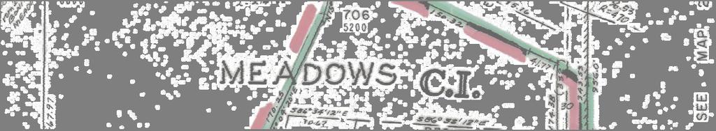
10 5 Annexation to the City of Lake Oswego AN /Ordinance 2812 Meadows Rd CR&D CR&D TL Meadows 5000 Rd Ave R Bonita Rd TL Carman Dr 1615 TL SW Carman Dr TL R TL TL TL SW Waluga Meadow Attachment A Carman Dr 5110 R CR&D Dr Tax Lot IDs:21E07AB00700, 21E07AB00701, 21E07AB00705, 21E07AB00706, 21E07AB00708, 21E07AB00800, 21E07AB00801 City of Lake Oswego: COMPREHENSIVE PLAN = CR&D/R-7.5 ZONING = CR&D/R-7.5 ³ Clackamas County: ZONING = CI/R-8.5, Mixed Use Lake Oswego Subject City Limits Properties Feet /23/


11 5 Meadows Rd Annexation to the City of Lake Oswego AN /Ordinance 2812 RP TL Ave Meadows 5000 Rd RP 5195 TL TL TL TL TL Meadow Carman Dr Bonita Rd Langford Ln 5215 TL SW Carman Dr White Oaks Dr 5180 Attachment B Waluga Dr Tax Lot IDs:21E07AB00700, 21E07AB00701, 21E07AB00705, 21E07AB00706, 21E07AB00708, 21E07AB00800, 21E07AB00801 RP WRG ³ RC Lake Oswego City Limits HBA Subject Properties Feet 1/15/2019
12 February 13, 2019 ATTACHMENT C Criteria, Findings, Conclusion, and Effective Date APPLICABLE CRITERIA: A. Oregon Revised Statutes (ORS), Boundary Changes; Mergers and Consolidations. 1. ORS (2): Annexation of Contiguous Territory, Authority and Procedure for Annexation, Generally. 2. ORS : Authorizes annexation of unincorporated territory surrounded by a city. B. Metro Code : Hearing and Decision Requirements for Decisions other than Expedited Decisions. C. Lake Oswego Community Development Code 1. Section : Zoning of Annexed Areas 2. Section : Comprehensive Plan Map Designations Automatically applied Upon Annexations; Exceptions. D. Comprehensive Plan - Urbanization Chapter 1. Policy A-3: The Urban Services Boundary (as depicted on the Comprehensive Plan Map) is the area within which the City shall be the eventual provider of the full range of urban services. 2. Policy C-2: The City may initiate island annexations as allowed by state law to: a. Create logical City boundaries; and b. Provide economic and efficient provision of City services to existing and proposed development within the subject area and to adjacent land. 3. Policy C-3: Ensure that annexation of new territory or expansion of Lake Oswego s Urban Services Boundary does not detract from the City s ability to provide services to existing City Residents. 4. Policy C-4: Prior to the annexation of non-island properties, ensure urban services are available and adequate to serve the property or will be made available in a timely manner by the City or a developer commensurate with the scale of the proposed development. Ordinance 2812 (AN , 21E07AB00708, 00801, 00800, 00706, 00705, 00701, 00700) ATTACHMENT C/PAGE 1 OF 11
13 February 13, 2019 FINDINGS: A. Oregon Revised Statutes (ORS), Boundary Changes; Mergers and Consolidations. 1. ORS (2) Annexation of Contiguous Territory, Authority and Procedure for Annexation, Generally. ORS (2) provides that a proposal for annexation of territory to a City may be initiated by the legislative body of the City, on its own motion, or by a petition to the legislative body of the City by owners of real property in the territory to be annexed. The proposed annexation was initiated by the Lake Oswego City Council on September 18, 2018 and directed staff to initiate annexation proceedings of this territory that is completely surrounded by the City s jurisdictional limits. The proposed annexation complies with this statute. 1. ORS Annexation of Unincorporated Territory Surrounded by a City. ORS provides that territory surrounded by a city may be annexed without consent of the property owners or residents. Not more than 25 percent of the surrounding corporate boundaries may consist only of a public right of way. AN was initiated at the direction of the Lake Oswego City Council on September 18, The territory is completely surrounded by the City s corporate boundaries. As shown on Attachment A to proposed ordinance 2802 (Exhibit A-1) far less than 25 percent of the surrounding corporate boundaries consist of only incorporated public right of way: a small segment of Bonita Rd. south of TL 00708, and small segments of Carman Dr. that are southeast of TL and TL and adjacent to the southern terminus of unincorporated Meadows Ave. The proposed annexation will result in the addition of approximately 5.0 acres of residential and office land to the City (1.5 Acres of office zoned CR&D and 3.22 acres of residential land zoned R-7.5), plus the public right of way for Meadow Avenue. The annexation complies with ORS B. Metro Code Hearing and Decision Requirements for Decisions Other Than Expedited Decisions. (A) (B) The following requirements for hearings on petitions rate in addition to the requirements for boundary changes in ORS Chapters 198, 221, and 222 and the reviewing entities charter ordinance or resolutions. Not later than 15 days prior to the date set for a boundary change decision, the approving entity shall make available to the public a report that addresses the criteria identified in subsection (D) and includes the following information: (1) The extent to which urban services are available to serve the affected territory including any extra-territorial extensions of service. The territory is located within the Urban Growth Boundary and the City s Urban Services boundary. Metro code section defines urban services as including sanitary sewers, water, fire protection, parks, open space, recreation, streets, roads and mass transit. Ordinance 2812 (AN , 21E07AB00708, 00801, 00800, 00706, 00705, 00701, 00700) ATTACHMENT C/PAGE 2 OF 11
14 February 13, 2019 Water: Water is available to this area from a Lake Grove Water District (LGWD) line and is served by the LGWD. LGWD mains are located in in Meadows Road, Meadow Avenue, Carman Drive and Bonita Road along the site frontages. The territory will remain in the LGWD and will continue to be a LGWD customer. Fire hydrants are located along the site frontages of Meadows Road and at the intersections of Meadow Avenue and Carman Drive and Bonita Road and Carman Drive. Sewer: Sanitary sewer is available from public sewer mains owned by the Clean Water Services District (CWSD) located along the northern boundary of 5195, 5165 Bonita Road and 4948 Meadow Avenue. A sewer main is also located in Meadow Avenue from the northeast corner of 4948 Meadow Avenue and extends south to Carman Drive. These lines were constructed according to the plan outlined in the Intergovernmental Agreement (IGA) between the City of Lake Oswego, City of Tualatin and CWSD. Staff also notes a future sewer connection of 5215 Bonita Road may require a public sewer extension be constructed in Bonita Road. Any on-site work that would involve decommissioning existing septic tanks would require removal, or filling with sand or gravel. All work would be completed by private contractors. Clean Water Services (CWS) charges customers within the City for their services per an IGA between Lake Oswego and CWSD signed on April 14, The IGA requires the CWSD to maintain gravity sewer lines so long as there is a property served by the District connected to that line or anywhere upstream. District responsibility will end after the first upstream manhole above the last property served by District. This territory is the furthest upstream served by the CWS and can be removed from the District upon annexation. The City would assume maintenance and management responsibilities for the sanitary system in this area. The final transfer of maintenance responsibilities from CWSD to the City of Lake Oswego will occur under a separate procedure after annexation. Storm water: Tax Lots 700, 701, 800 and 801 are within the Surface Water Management Agency of Clackamas County (SWMACC) and the storm water facilities on the remaining parcels are within the Clean Water Services Storm Water Management area and are maintained by CWSD. Fire Protection: Tualatin Valley Fire and Rescue District provides fire protection services to the territory by agreement with the City of Lake Oswego. Upon annexation, the territory will be withdrawn from this fire district and served directly by the City. The Westlake Fire Station #210, located on 4900 Melrose Street northeast of the territory, would be able to respond to emergencies within this neighborhood within the eight minute goal established in the Comprehensive Plan. Police: Upon annexation, the territory will be withdrawn from the Clackamas County Enhanced Sheriff s Patrol District and served by the City of Lake Oswego. The Lake Oswego Police Department reviewed the proposal and indicated that it does not have any concerns with serving this territory upon annexation. Ordinance 2812 (AN , 21E07AB00708, 00801, 00800, 00706, 00705, 00701, 00700) ATTACHMENT C/PAGE 3 OF 11
15 February 13, 2019 Parks and Open Space: The City has 537 acres of park and open space lands, or 14.6 acres per 1,000 population. The parks nearest to the territory are Westlake Park, Waluga Park East, and Waluga Park West. Westlake Park is Located on Melrose Street near the intersection of Melrose Street and Fosberg Road and consists of 12 acres. It has three lighted baseball/softball fields, two lighted soccer fields, lighted tennis courts, full court basketball, and a new covered playground. The covered shelter has six picnic tables, lights, electricity and restrooms. Waluga Park East and West are located north of Oakridge Road and East and West of Waluga Drive. These two parks consist of 53 acres of active and natural passive areas. West Waluga Park includes two lighted baseball fields, a playground, picnic shelters, lights and restrooms. Lake Grove Park District: The Lake Grove Swim Park, managed by the Lake Oswego School District and funded by the Lake Grove Park District, is located at 3800 Lakeview Boulevard. The swim park is approximately 1.3 acres in size with restroom, play and swim facilities. This territory will remain within the Lake Grove Park District following annexation. Transportation - Streets and Mass Transit: Meadows Road, Carman Drive and Bonita Road are all designated as major collector level roads in the City s functional street classification system and are under the maintenance jurisdiction and permitting authority of the City of Lake Oswego. Meadow Avenue is a Clackamas County unmaintained public road and will automatically transfer to the City s jurisdiction upon annexation. The section of right-of-way between Carman Drive and Meadows Road is currently developed as a parking lot along 5200 Meadows Road and a gravel access way along 4948 and 4950 Meadow Avenue. The nearest mass transit service is Tri Met Line 38, which runs along Boones Ferry Road and Kruse Way and connects to the Tualatin Transit Center. As noted above, police and fire services are available upon annexation. The amount of protection provided will be similar to protection provided to other City residents because the territory proposed to be annexed is not isolated from other areas of the City. 2. Whether the proposed boundary change will result in the withdrawal of affected territory from the legal boundary of any necessary party; and, The annexed area lies within the following districts and shall be withdrawn from these districts upon the effective date of annexation: Clean Water Services Sanitary District Tualatin Valley Fire and Rescue District Clackamas County Enhanced Sheriff s Patrol District Surface Water Management Agency of Clackamas County Ordinance 2812 (AN , 21E07AB00708, 00801, 00800, 00706, 00705, 00701, 00700) ATTACHMENT C/PAGE 4 OF 11
16 February 13, 2019 The annexed area lies within the following districts and shall be retained within these districts upon the effective date of annexation: Lake Grove Park District Lake Grove Water District 3. The proposed effective date of the boundary Change The effective dates of the decision to annex the annexation ordinance and effective date of annexation for the commercial property and the delayed annexation of the residential property are addressed under Effective Date on Page 10 of this report. (C). (D). The person or entity proposing the boundary change has the burden to demonstrate that the proposed boundary change meets the applicable criteria Through the evidence provided in the findings, the City has met the burden to demonstrate that the proposed boundary change meets the criteria. To approve a boundary change, the reviewing entity shall apply the criteria and consider the factors set forth in subsections D and E of Metro Code section (Expedited Decisions). To approve the boundary change the City shall: 1. Find that the change is consistent with expressly applicable provisions in: a. Any applicable urban service agreement adopted pursuant to ORS The City has entered into - ORS agreements with: 1) Lake Oswego School District; and, 2) Lake Grove Fire District. 3) Clackamas County (for roadways). The intergovernmental agreement with the Rivergrove Water District is not discussed in this section because it was entered into before the adoption of ORS , and consequently does not include all of the provisions necessary to be considered an urban service agreement under that statute. Lake Oswego School District: The City and the Lake Oswego School District entered into an ORS urban service agreement for park services in July, The School District operates the Lake Grove Swim Park located at 3800 Lakeview Boulevard. The agreement states that the annexation of this territory by the City within the Lake Grove Park District (which funds the swim park) shall not cause the withdrawal of the territory from the district. Lake Grove Fire District #57: The City and District entered into an ORS urban service agreement for fire protection in July, The agreement states that upon annexation of property within the district by the City, the annexed property shall be withdrawn from the District and the City shall provide fire protection services. Clackamas County Roadways: The City and Clackamas County entered into an ORS urban service agreement for Roadways in July, The agreement states that upon annexation of the roadways within unincorporated areas, the City shall, within 60 days of the effective date of the annexation, initiate proceedings for the transfer of jurisdiction all of the County Roads within the annexed areas. Transfer proceedings shall comply with ORS Ordinance 2812 (AN , 21E07AB00708, 00801, 00800, 00706, 00705, 00701, 00700) ATTACHMENT C/PAGE 5 OF 11
17 February 13, 2019 Meadow Avenue will be annexed as a part of this action. Meadows Road, Carman Drive and Bonita Road are within the City and designated as major collector level roads in the City s functional street classification system and are under the maintenance jurisdiction and permitting authority of the City of Lake Oswego. Meadow Avenue is a Clackamas County unmaintained public road and will automatically transfer to the City s jurisdiction upon annexation. b. Any applicable annexation plan adopted pursuant to ORS There are no applicable annexation plans adopted pursuant to ORS relating to the affected territory. c. Any applicable cooperative planning agreement adopted pursuant to ORS (2) between the affected entity and a necessary party. There are no ORS (2) cooperative agreements (which relate to special districts) between the city and a necessary party. d. Any applicable public facility plan adopted pursuant to a statewide planning goal on public facilities and services Sanitary sewer is available from public sewer mains owned by the Clean Water Services District (CWS) located along the northern boundary of 5195, 5165 Bonita Road and 4948 Meadow Avenue. A sewer main is also located in Meadow Avenue from the northeast corner of 4948 Meadow Avenue and extends south to Carman Drive. These lines were constructed according to the plan outlined in the Intergovernmental Agreement (IGA) between the City of Lake Oswego, City of Tualatin and Clean Water Services District and the City Wastewater Master Plan and the City s Public Facility Plan. The properties will continue to be served by this system which will be maintained and operated by the City of Lake Oswego Upon annexation. e. Any applicable comprehensive plan policies Comprehensive Plan Map: The territory to be annexed is currently under Clackamas County s jurisdiction. The single family residential properties are zoned Low Density Residential (R-8.5) and the property at 5200 Meadows Road is designated Campus Industrial (C-I) on Clackamas County s zoning map. The territory to be annexed has two Comprehensive Plan designations. The property supporting the office building located at 5200 Meadows Road is designated Campus Research and Development (CR&D) and the remaining properties have a Comprehensive Plan designation of Single-Family (R-7.5); which allows for a minimum lot size of 7,500 square feet. The property located at 5200 Meadows Road and the adjacent Meadow Avenue public right of way east of the property will be zoned CR&D and the remaining properties and the adjacent Meadow Avenue public right of way east of these properties will be designated R-7.5 upon annexation. Ordinance 2812 (AN , 21E07AB00708, 00801, 00800, 00706, 00705, 00701, 00700) ATTACHMENT C/PAGE 6 OF 11
18 February 13, 2019 The City and County have coordinated their comprehensive plans within the Dual Interest Area outlined in the City/County Urban Growth Management Agreement (dated February 4, 1992 and updated November 18, 1997), hence the City/County designations have been determined to be compatible. Therefore, this annexation is consistent with the City s Comprehensive Plan Map. Comprehensive Plan Policies: The Lake Oswego Comprehensive Plan contains the following relevant language in the Urbanization chapter: Policy A-3: The Urban Services Boundary (as depicted on the Comprehensive Plan Map) is the area within which the City shall be the eventual provider of the full range of urban services. The City will be the eventual provider of urban services in this area. The proposed annexation and the withdrawal of this territory from the identified districts are consistent with this policy. Policy C-2 states: The City may initiate island annexations as allowed by State law to: a. Create logical city boundaries b. Provide economic and efficient provision of City services to existing and proposed development within the subject area and to adjacent land. Annexation of this territory will eliminate the island of unincorporated property and will consolidate lands within the city resulting in a more logical city boundary. This annexation will bring public assets into the city and provide these public services in a more uniform and efficient manner. Policy C-3 states: Ensure that annexation of new territory or expansion of Lake Oswego s Urban Services Boundary does not detract from the City s ability to provide services to existing City residents. The approval of this annexation will result in the addition of 5.0 acres to be served by the City. As stated in Section 2(b)(1), the addition of this territory will not detract from the City s ability to provide police and fire protection to existing City residents. Annexation of this territory will not affect the City s ability to provide parks and recreation services to existing residents. Public facilities, such as sewer and water are also found to be adequate to serve this territory without detracting from services to existing residents. Comprehensive Plan Policy C-4 states: Prior to the annexation of non-island properties, ensure urban services are available and adequate to serve the property or will be made available in a timely manner by the City or a developer commensurate with the scale of the proposed development. The availability of urban services has been discussed in detail under Metro Code Section (B)(1), above. Urban Growth Management Agreement: General Urbanization Policy 4.A.4 of the Clackamas County Comprehensive Plan calls for the establishment of Urban Growth Management Areas and Urban Growth Management Agreements to clarify planning responsibilities between the County and cities for areas of mutual interest. Policy 4.A.5 directs the County to establish agreements with cities and service districts to clarify service and infrastructure responsibilities for areas of mutual interest. Ordinance 2812 (AN , 21E07AB00708, 00801, 00800, 00706, 00705, 00701, 00700) ATTACHMENT C/PAGE 7 OF 11
19 February 13, 2019 Similarly, the Lake Oswego Comprehensive Plan, Urbanization Chapter, Policy D-3, calls for entering into and maintaining an Urban Growth Management Agreement (UGMA) with Clackamas County for lands within the Urban Services Boundary. In furtherance of these policies, the City and County have entered into an Urban Growth Management Agreement that stipulates a mutual interest in coordinated land use planning, compatible comprehensive plans and provision of urban services and facilities. This agreement ensures coordination and consistency between the City and County comprehensive plans and outlines responsibilities in providing services and managing growth within the Dual Interest Area. Subsections 6 and 7, provided below, are applicable to annexations. 6. City and County Notice and Coordination: The City shall provide notification to the County, and an opportunity to participate, review and comment, at least 35 days prior to the first public hearing on all proposed public facilities plans, legislative changes to the City Comprehensive Plan, or quasijudicial land use actions adjacent to, or in close proximity to unincorporated areas. The City shall provide notice to the County of private or City initiated annexation requests within five days of the filing of an application with the Portland Metropolitan Boundary Commission. The Urban Growth Management Agreement specifies that the City notify the County of an annexation request within five days of when it is submitted to the Boundary Commission. There is no longer a Boundary Commission for the Portland Metropolitan area. Staff relies on the notice requirements of Metro Code , which requires notice 20 days prior to the annexation decision for all necessary parties (other governmental entities). 7. City Annexations A. The City may undertake annexations in the manner provided for by law within the Dual Interest Area. The City annexation proposals shall include adjacent road right-of-way to property proposed for annexation. The County shall not oppose such annexations. B. Upon annexation, the City shall assume jurisdiction of the County roads and local access roads pursuant to a separate road transfer agreement between the City and county. The City is undertaking this annexation in the manner provided for in the applicable state statutes and Metro Code provisions for the territories that lie within the Dual Interest Area. This annexation is consistent with the City and County comprehensive plans which have been coordinated in the Dual Interest Area within the regional Urban Growth Boundary (UGB). The Meadow Avenue right-of-way will be annexed as a part of this action. Meadows Road, Carman Drive and Bonita Road are all designated as major collector level roads in the City s functional street classification system and are under the maintenance jurisdiction and permitting authority of the City of Lake Oswego. Ordinance 2812 (AN , 21E07AB00708, 00801, 00800, 00706, 00705, 00701, 00700) ATTACHMENT C/PAGE 8 OF 11
20 February 13, 2019 Meadow Avenue is a Clackamas County unmaintained public road and will automatically transfer to the City s jurisdiction upon annexation. The section of right-of-way between Carman Drive and Meadows Road is currently developed as a parking lot along 5200 Meadows Road and a gravel access way along 4948 and 4950 Meadow Avenue. f. Any applicable concept plan There are no concept plans for this territory. 2. Consider whether the boundary change would a. Promote the timely orderly and economic provision of public facilities and services b. Affect the quality and quantity of urban services c. Eliminate or avoid unnecessary duplication of facilities or services This territory is served by a sanitary sewer system that is a part of the Clean Water Services Sewer District and will become a city service after annexation. The water system will remain in the Lake Grove Water District. All other services discussed under LOC (B) above, will also be available upon annexation. Therefore, this annexation will promote the timely, orderly and economical extension of public facilities and services. The territory can readily be served with urban services and facilities. If and when additional development occurs in the area, provision of public facilities and services will occur consistent with the City s adopted public facility master plans, ensuring that it does not adversely affect the quality or quantity of urban services and avoiding unnecessary duplication of facilities or services. Therefore, this boundary change is consistent with criteria 2.a through 2.c. (E) A city may not annex territory that lies outside the UGB except it may annex a lot or parcel that lies partially within and partially outside the UGB. This territory is located entirely within the City s Urban Growth Boundary (UGB). C Lake Oswego Community Development Code 1. Section : Zoning of Annexed Areas 2. Section : Comprehensive Plan Map Designations Automatically applied Upon Annexations; Exceptions. Plan and Zone Designation: The territory is currently under Clackamas County s jurisdiction. The residential properties are zoned R-8.5 (Low Density Residential) and the property at 5200 Meadows Road is zoned CI (Campus Industrial). The subject territory has two City of Lake Oswego Comprehensive Plan designations. The property supporting the office building located at 5200 Meadows Road, and the adjacent Meadow Ave. rightof-way is designated CR&D (Campus Research and Development) and the remaining properties, and adjacent Meadow Ave. right-of-way, have a Comprehensive Plan designation of R-7.5 (Single- Family), which allows for a minimum lot size of 7,500 square feet. Ordinance 2812 (AN , 21E07AB00708, 00801, 00800, 00706, 00705, 00701, 00700) ATTACHMENT C/PAGE 9 OF 11
21 February 13, 2019 Under LOC and , upon Annexation the property located at 5200 Meadows Road (and adjacent right-of-way) will be zoned CR&D (Campus Research and Development, which allows a wide variety of commercial and office uses) and the remaining properties (and adjacent right-of-way) will be designated R-7.5 (single-family). Sensitive Lands: The Sensitive Lands Map shows a Class 2 Sensitive Lands Resource (Carter Creek) in the City s Comprehensive Plan, extending along the northern property boundaries of tax lots 700, 701 and 801 and the southern boundary of tax lot 706. Pursuant to LOC a, this zoning overlay will be automatically applied to this property upon annexation (Attachments A and B). Property owners have the opportunity to contest the application of an existing RP, RC District, or HBA (Habitat Benefit Area) designation under LOC b: Where the Comprehensive Plan Map indicates an RP, RC or HBA District designation on territory proposed for annexation, the City shall notify the owners of the annexing territory that they have 20 days prior to the initial public hearing on the annexation to contest the designation pursuant to LOC , Sensitive Lands Overlay Districts. No fee shall be charged for such review. If, following review, the decision-maker determines the property was improperly designated, the RP, RC or HBA designation shall be removed. The property owners within this territory were notified about the option to contest the RP District designation on December 18, They have not contested the designation pursuant to LOC b. The property owners at 5215 Bonita Road sent an to staff on January 15 affirming that there are no Sensitive Lands overlay designations on their property. Staff responded by assuring the property owner there are no Sensitive Lands designations on the property and that there would be no overlays designated on the property as a part of this annexation. CONCLUSION: Based on the criteria and findings set forth above, the City Council concludes that AN complies with all applicable criteria and the annexation should be approved. EFFECTIVE DATE: A. Effective Date of Decision to Annex. The annexation decision shall be final upon the date of enactment of the annexation ordinance. B. Effective Date of Annexation Ordinance. Pursuant to Lake Oswego City Charter, Section 35.C., the ordinance shall be effective on the 30 th day after its enactment. C. Effective Date of Annexation. 1. For 5200 Meadows Road (TL 706), which was not zoned for and in residential use as of the initiation of this annexation, plus the Meadows Avenue right-of-way: Following the filing of the annexation records with the Secretary of State as required by ORS , this annexation shall be effective upon the later of: a. the 30 th day following the date of adoption of this ordinance; or b. the date of filing of the annexation records with the Secretary of State; Ordinance 2812 (AN , 21E07AB00708, 00801, 00800, 00706, 00705, 00701, 00700) ATTACHMENT C/PAGE 10 OF 11
22 February 13, 2019 provided however that pursuant to ORS (2), if the effective date of the annexation as established above is a date that is within 90 days of a biennial primary or general election or after the deadline for filing notice of election before any other election held by any City, district or other municipal corporation involved in the area to be annexed, then the effective date of the annexation shall be delayed until, and the annexation shall become effective on, the day after the election. 2. For 5165 Carman Drive (TL 700), 5195 Bonita Road (TL 705), 5215 Bonita Road (TL 708), 4950 Meadow Avenue (TL 800), 4948 Meadow Avenue (TL 801) and one parcel with no situs address at 21E07AB 00700, together with the Meadow Avenue right-of-way, which are properties zoned for and in residential use as of the initiation of this annexation, pursuant to ORS (5) this annexation shall be effective on March 7, 2022 provided, however, that pursuant to ORS (2), if the effective date of the annexation as established above is a date that is within 90 days of a biennial primary or general election or after the deadline for filing notice of election before any other election held by any City, district or other municipal corporation involved in the area to be annexed, then the effective date of the annexation shall be delayed until, and the annexation shall become effective on, the day after the election. The city recorder or other officer performing the duties of the city recorder shall: a. Cause notice of the delayed annexation to be recorded by the county clerk of the county in which any part of the territory subject to delayed annexation is located within 60 days after the city proclaims the annexation approved; and b. Notify the county clerk of each county in which any part of the territory subject to delayed annexation is located not sooner than 120 days and not later than 90 days before the annexation takes effect. Ordinance 2812 (AN , 21E07AB00708, 00801, 00800, 00706, 00705, 00701, 00700) ATTACHMENT C/PAGE 11 OF 11
23 PAGE 1 OF ATTACHMENT D AN MEADOWS ROAD TAX LOT 21E07AB00706 RIGHT OF WAY: A PORTION OF MEADOW AVENUE A tract of land located within the northeast quarter of Section 7, Township 2 South, Range 1 East of the Willamette Meridian, City of Lake Oswego, Clackamas County, Oregon, said tract being a part of Lot 7, Bonita Meadows (Plat No. 285), plat records of Clackamas County, said tract further identified as Parcel I of Document No , deed records of Clackamas County, more particularly described as follows: Beginning at the northeast corner of Parcel 1, Partition Plat No , plat records of Clackamas County, said point being on the westerly right of way of Meadow Avenue; Thence leaving said right of way, South West, along a line being common to the northerly line of Parcel 1 of said Partition Plat and the southerly line of said Parcel I of Document No , feet, to the south-southwest corner of said Parcel I of Document No ; Thence leaving said common line, North West, along the southwesterly line of said Parcel I of Document No , feet, to the west-southwest corner thereof; Thence leaving said southwesterly line, North East, along the northwesterly line thereof, feet, to an angle point thereof; Thence continuing along said northwesterly line, North East, feet to the southwesterly right of way of Meadows Road; Thence leaving said northwesterly line, southeasterly along said southwesterly right of way, along the arc of a non-tangent curve, having a radius of feet to the right, through a H:\Surveying Services\Annexation\2018\AN (5200 Meadows Rd)\Legal Description\AN _ PAGE 1 OF ATTACHMENT D.docx
24 Page 2 of 2 central angle of (the long chord of which bears South East, feet), feet to a point of tangency; Thence continuing along said right of way, South East, feet to a point of curvature; Thence along the arc of a foot radius curve to the left, through a central angle of (the long chord of which bears South East, feet), feet, to the westerly right of way of said Meadow Avenue, feet from the centerline thereof, when measured at right angles; Thence leaving said southwesterly right of way, South West, along said westerly right of way, feet, more or less, to the point of beginning. Together with a portion of Meadow Avenue (also identified as Meadows Avenue on said Partition Plat No ), the right of way thereof being created by said Bonita Meadows (Plat No. 285), said portion being feet wide; said portion lying westerly of the east line of said Bonita Meadows, and easterly of the east line of said Lot 7; said portion being bounded on the north by the southeasterly extension of the southwesterly right of way of Meadows Road, to the east line of said Bonita Meadows; said portion being bounded on the south by the southerly line of said Lot 7, said line also being the easterly extension of the northerly line of Parcel 1 of said Partition Plat. Said portion being 169 feet in length, more or less. The Documents referenced herein, being of the deed records of Clackamas County.


25
26 PAGE 1 OF ATTACHMENT E AN DELAYED ANNEXATION AREA 4948 AND 4950 MEADOW AVENUE 5165 SW CARMAN DRIVE 5195 AND 5215 SW BONITA ROAD TAX LOTS: 21E07AB00700, 21E07AB E07AB00705, 21E07AB E07AB00800, 21E07AB00801 RIGHT OF WAY: A PORTION OF MEADOW AVENUE A tract of land located within the northeast quarter of Section 7, Township 2 South, Range 1 East of the Willamette Meridian, City of Lake Oswego, Clackamas County, Oregon, said tract being a part of Lot 6, Bonita Meadows (Plat No. 285), plat records of Clackamas County, said tract of land more particularly described as follows: Beginning at the northeast corner of Parcel 1, Partition Plat No , plat records of Clackamas County, said point being on the westerly right of way of Meadow Avenue; Thence along said westerly right of way, South West, feet to an angle point in the easterly line of Parcel 2 of said Partition Plat; Thence leaving said westerly right of way and continuing along the northwesterly right of way thereof, South West, 199 feet, more or less, to a point being common to the northeast corner of that tract of land described in Document No and the southeast corner of that tract of land described in Document No ; Thence leaving said right of way, North West, along a common northeasterly and southwesterly line thereof, feet, more or less, to the northwest corner of said Document No and the most east corner of that tract of land described in Document No and ; H:\Surveying Services\Annexation\2018\AN DELAYED (5195, 5215 Bonita Rd; 4948, 4950 Meadows Ave; 5165 Carman Rd)\Legal Description\AN _DELAYED_ PAGE 1 OF ATTACHMENT E.docx
27 Page 2 of 3 Thence leaving said northeasterly and southwesterly common line, South West, along a common northwesterly and southeasterly line of said Documents No , , and respectively, 192 feet, more or less (deed record states feet in Document No ; deed records state feet in Documents No and ), to the northerly right of way of Bonita Road (County Road No. 929); Thence leaving said common line, South West, along said right of way, feet, more or less, to the most south-southwest corner of said tract described in said Documents No and ; Thence continuing along said right of way and the most south-westerly line of said tract thereof, North East, 12.8 feet, more or less, to the southeast corner of that tract of land described in Document No ; Thence along the southerly line thereof, and also continuing along said northerly right of way, South West, feet, more or less, to a point on the west line of said Lot 6; Thence leaving said southerly line and northerly right of way, North, along the west line of said Lot 6, feet, more or less, to the west-northwest corner thereof; Thence leaving said west line, North East, along the northwesterly line thereof, feet, more or less, to the north-northwest corner thereof; Thence leaving said northwesterly line, North East, along the northerly line thereof, 357 feet, more or less, to the point of beginning. Together with a portion of Meadow Avenue (also identified as Meadows Avenue on said Partition Plat No ), the right of way thereof being created by said Bonita Meadows (Plat No. 285), said portion being variable in width; said portion lying westerly of the east line of said Bonita Meadows, and easterly/southeasterly of the east/southeasterly lines of said Lot 6; said portion being bounded on the north by the northerly line of said Lot 6, said line also being the easterly extension of the northerly line of Parcel 1 of said Partition Plat; said portion being bounded on the south by the westerly extension of the of the north line of Bryant Acres Plat 4 (Plat No. 591), to the southeasterly line of Parcel 2 of said Partition Plat. Said portion being 227 feet in length, more or less.
28 The Documents referenced herein, being of the deed records of Clackamas County. Page 3 of 3


29
Kent Studebaker, Mayor Members of the City Council. Paul Espe, Associate Planner. Ordinance Annexing Property at 5022 Upper Drive (AN )
") TO: FROM: SUBJECT: Kent Studebaker, Mayor Members of the City Council Paul Espe, Associate Planner Ordinance 2776 - Annexing Property at 5022 Upper Drive (AN 17-0011) DATE: March 26, 2018 Date of Meeting:
TO: FROM: SUBJECT: Kent Studebaker, Mayor Members of the City Council Paul Espe, Associate Planner Ordinance 2776 - Annexing Property at 5022 Upper Drive (AN 17-0011) DATE: March 26, 2018 Date of Meeting:
Ordinance 2755 Annexing Property at and Boones Ferry Road (AN )
") TO: FROM: SUBJECT: Kent Studebaker, Mayor Members of the City Council Paul Espe, Associate Planner Ordinance 2755 Annexing Property at 16607 and 16667 Boones Ferry Road (AN 17-0007) DATE: March 16, 2018
TO: FROM: SUBJECT: Kent Studebaker, Mayor Members of the City Council Paul Espe, Associate Planner Ordinance 2755 Annexing Property at 16607 and 16667 Boones Ferry Road (AN 17-0007) DATE: March 16, 2018
Ordinance 2676, annexing Goodall Road (AN )
") 8.5 TO: FROM: SUBJECT: Kent Studebaker, Mayor Members of the City Council Scott Lazenby, City Manager Paul Espe, Associate Planner Ordinance 2676, annexing 13590 Goodall Road (AN15-0010) DATE: June 19,
8.5 TO: FROM: SUBJECT: Kent Studebaker, Mayor Members of the City Council Scott Lazenby, City Manager Paul Espe, Associate Planner Ordinance 2676, annexing 13590 Goodall Road (AN15-0010) DATE: June 19,
Washington County King City Urban Planning Area Agreement
 Washington County King City Urban Planning Area Agreement Washington County City of King City UPAA Page 1 of 7 THIS AGREEMENT is entered into by WASHINGTON COUNTY, a political subdivision in the State
WASHINGTON COUNTY OREGON
 WASHINGTON COUNTY OREGON July 28, 2006 To: From: Citizen Participation Organizations and Interested Parties Brent Curtis, Planning Manager Department of Land Use and Transportation Subject: PROPOSED ORDINANCE
Resolution 17-52, Initiating Proceedings to Vacate Portions of the right-of-way for Boones Ferry Road, Kruse Way, and Kruse Way Place
 14.6 TO: FROM: SUBJECT: Kent Studebaker, Mayor Members of the City Council Erica Rooney, P.E., City Engineer Tom Workman, City Surveyor Engineering Department Resolution 17-52, Initiating Proceedings to
Intergovernmental Agreement. For Growth Management. City of Loveland, Colorado and Larimer County, Colorado
 Intergovernmental Agreement For Growth Management City of Loveland, Colorado and Larimer County, Colorado Approved January 12, 2004 Intergovernmental Agreement for Growth Management Table of Contents 1.0
PETITION FOR ANNEXATION
 City of Moab 217 East Center Street Main Number (435) 259-5121 Fax Number (435) 259-4135 PETITION FOR ANNEXATION Petition date: Petition Description (Approximate Address): Contact Sponsor Name: Contact
Department of Land Conservation and Development 635 Capitol Street, Suite 150 Salem, OR Theodore R. Kulongoski, Governor (503)
") Oregon Department of Land Conservation and Development 635 Capitol Street, Suite 150 Salem, OR 97301-2540 Theodore R. Kulongoski, Governor (503) 373-0050 NOTICE OF ADOPTED AMENDMENT September 5, 2008 Fax
Oregon Department of Land Conservation and Development 635 Capitol Street, Suite 150 Salem, OR 97301-2540 Theodore R. Kulongoski, Governor (503) 373-0050 NOTICE OF ADOPTED AMENDMENT September 5, 2008 Fax
Ordinance Fact Sheet
 Ordinance Fact Sheet TO: CITY COUNCIL DATE: January 7,2008 FROM: SUBJECT: CITY ATTORNEY AN ORDINANCE AMENDING THE NORTH LAKE SPECIFIC PLAN OVERLAY DISTRICT TITLE OF PROPOSED ORDINANCE AN ORDINANCE OF THE
MONTGOMERY COUNTY PLANNING DEPARTMENT
 MONTGOMERY COUNTY PLANNING DEPARTMENT THE MARYLAND-NATIONAL CAPITAL PARK AND PLANNING COMMISSION Becraft Properties, The City of Gaithersburg Annexation X-7969-2018 MCPB Item No. Date: 9-13-18 Troy Leftwich,
Ordinance 2713 Marijuana Facility Regulations
 8.1 TO: FROM: SUBJECT: Kent Studebaker, Mayor Members of the City Council David Powell, City Attorney Ordinance 2713 Marijuana Facility Regulations DATE: September 13, 2016 ACTION Enact Ordinance 2713
DLCD ACKNOWLEDGMENT or DEADLINE TO APPEAL: Wednesday, September 01, 2010
 Oregon Theodore R KjibngDski, Governor Department of Land Conservation and Development 635 Capitol Street, Suite 150 Salem, OR 97301-2540 (503) 373-0050 Fax (503) 378-5518 www. lcd.state.or.us NOTICE OF
s 2 Notice of Adoption THIS FORM MUST BE MAILED TO DLCD WITHIN 5 WORKING DAYS AFTER THE FINAL DECISION PERORS , OAR CHAPTER DIVISION 18
 Oregon Theodore R KjibngDski, Governor Department of Land Conservation and Development 635 Capitol Street, Suite 150 Salem, OR 97301-2540 (503) 373-0050 Fax (503) 378-5518 www. lcd.state.or.us NOTICE OF
CITY OF HOOD RIVER PLANNING APPLICATION INSTRUCTIONS
 CITY OF HOOD RIVER PLANNING APPLICATION INSTRUCTIONS 1. The attached application is for review of your proposed development as required by the Hood River Municipal Code ( Code ). Review is required to
STAFF REPORT CITY OF LAKE OSWEGO PLANNING AND BUILDING SERVICES DEPARTMENT
 STAFF REPORT CITY OF LAKE OSWEGO PLANNING AND BUILDING SERVICES DEPARTMENT APPLICANT City of Lake Oswego LOCATION Industrial Park (IP) Zone DATE OF REPORT January 31, 2017 FILE NO. LU 17-0002 STAFF Jessica
DLCD ACKNOWLEDGMENT or DEADLINE TO APPEAL: Friday, December 26, 2008
 Department of Land Conservation and Development 35 Capitol Street, Suite 50 Salem, OR 9730-2540 (503) 373-0050 Fax (503) 378-558 www.lcdstate.or.us NOTICE OF ADOPTED AMENDMENT 2/0/2008 TO: FROM: SUBJECT:
CHAPTER 7 ANNEXATION Chapter Outline
 CHAPTER 7 ANNEXATION Chapter Outline 1. Definitions (UCA 10-2-401)... 1 2. Purpose... 1 3. Other Definitions (UCA 10-2-401)... 1 4. The Annexation Policy Plan (UCA 10-2-401.5)... 1-3 5. The Annexation
FIRST AMENDMENT TO INTERGOVERNMENTAL AGREEMENT BROADBAND USER'S GROUP (BUG)
") FIRST AMENDMENT TO INTERGOVERNMENTAL AGREEMENT BROADBAND USER'S GROUP (BUG) Shared Use of Public Communication Network, Internet Access, Communication Devices and Communication Equipment WHEREAS, the Cities
FIRST AMENDMENT TO INTERGOVERNMENTAL AGREEMENT BROADBAND USER'S GROUP (BUG) Shared Use of Public Communication Network, Internet Access, Communication Devices and Communication Equipment WHEREAS, the Cities
DEPT. OF COMMUNITY DEVELOPMENT SERVICES PLANNING AND ECONOMIC DEVELOPMENT DIVISION
 DEPT. OF COMMUNITY DEVELOPMENT SERVICES PLANNING AND ECONOMIC DEVELOPMENT DIVISION m e m o r a n d u m TO: FROM: Bruce K. Walden, CAO April D. Getchius, AICP, Director DATE: August 9, 2000 SUBJECT: An
ATTACHMENT 2 RESOLUTION 16-03
 ATTACHMENT 2 Resolution 16-03 Page 1 of 5 RESOLUTION 16-03 A RESOLUTION OF THE LAKE OSWEGO REDEVELOPMENT AGENCY BOARD REPEALING THE 2005 LAKE OSWEGO PUBLIC CONTRACT RULES AS PUBLIC CONTRACTING RULES FOR
ORDINANCE NO. 553 AN ORDINANCE OF THE CITY COUNCIL OF THE CITY OF LA QUINTA, CALIFORNIA, AMENDING SEVERAL CHAPTERS OF
 ORDINANCE NO. 553 AN ORDINANCE OF THE CITY COUNCIL OF THE CITY OF LA QUINTA, CALIFORNIA, AMENDING SEVERAL CHAPTERS OF TITLE 9 OF THE LA QUINTA MUNICIPAL CODE RELATED TO DEVELOPMENT STANDARDS WITHIN THE
ORDINANCE NO (2011)
") ORDINANCE NO. AN ORDINANCE OF THE CITY OF BOTHELL, WASHINGTON, PROVIDING FOR ANNEXATION TO BOTHELL OF UNINCORPORATED SNOHOMISH COUNTY TERRITORY KNOWN AS BLOOMBERG HILL ISLAND, AND FOR SIMULTANEOUS ADOPTION
ORDINANCE NO. AN ORDINANCE OF THE CITY OF BOTHELL, WASHINGTON, PROVIDING FOR ANNEXATION TO BOTHELL OF UNINCORPORATED SNOHOMISH COUNTY TERRITORY KNOWN AS BLOOMBERG HILL ISLAND, AND FOR SIMULTANEOUS ADOPTION
UNIFIED DEVELOPMENT CODE
 UNIFIED DEVELOPMENT CODE Page 1 Page 2 19.16 APPLICATIONS & PROCEDURES Contents: 19.16.010 General Requirements 19.16.020 Annexation 19.16.030 General Plan Amendment 19.16.040 Parcel Map 19.16.050 Tentative
DLCD ACKNOWLEDGMENT or DEADLINE TO APPEAL: Friday, November 27, 2009
 Oregon Theodore R KjibngDski, Governor Department of Land Conservation and Development 635 Capitol Street, Suite 150 Salem, OR 97301-2540 (503) 373-0050 Fax (503) 378-5518 www. lcd.state.or.us NOTICE OF
BOROUGH OF BUENA WORKSHOP AGENDA APRIL 8, 2019 PAGE 1
 PAGE 1 MEETING CALLED TO ORDER: P.M. MEETING ADJOURNED: P.M. CALL MEETING TO ORDER: Flag Salute ROLL CALL OF ATTENDANCE: SUNSHINE LAW: MAYOR S REPORT: PUBLIC HEARING: This meeting is being held in compliance
Oregon Theodore R. Kulongoski, Governor
 Oregon Department Theodore R. Kulongoski, Governor of Land Conservation and Development 635 Capitol Street, Suite 150 Salem, OR 97301-2540 (503)373-0050 Fax (503) 378-5518 www.lcd.state.or.us NOTICE OF
CITY OF SHELBYVILLE ANNEXATION PACKET SHELBYVILLE PLAN COMMISSION 44 WEST WASHINGTON STREET SHELBYVILLE, INDIANA OFFICE
 CITY OF SHELBYVILLE ANNEXATION PACKET SHELBYVILLE PLAN COMMISSION 44 WEST WASHINGTON STREET SHELBYVILLE, INDIANA 46176 OFFICE 317.392.5102 www.cityofshelbyvillein.com PROCEDURE FOR ANNEXATION INTO THE
ORDINANCE NO. An ordinance amending Chapter 51A, Dallas Development Code: Ordinance No , as
 9-23-14 ORDINANCE NO. An ordinance amending Chapter 51A, Dallas Development Code: Ordinance No. 19455, as amended, of the Dallas City Code by amending Section 51A-4.505, conservation districts; providing
ARTICLE 4 APPLICATION REVIEW PROCEDURES AND APPROVAL CRITERIA 3
 ARTICLE 4 APPLICATION REVIEW PROCEDURES AND APPROVAL CRITERIA 3 Chapter 4.1 General Review Procedures 4 4.1.010 Purpose and Applicability Error! Bookmark not defined. 4.1.020 Zoning Checklist 6 4.1.030
STAFF REPORT FROM: BRUCE BUCKINGHAM, COMMUNITY DEVELOPMENT DIRECTOR ~
 TO: STAFF REPORT HONORABLE MAYOR AND CITY COUNCIL FROM: BRUCE BUCKINGHAM, COMMUNITY DEVELOPMENT DIRECTOR ~ SUBJECT: SECOND READING AND ADOPTION OF ORDINANCE NO. 14-04 AMENDING GROVER BEACH MUNICIPAL CODE
CITY OF TORONTO. BY-LAW No (OMB) To adopt Amendment No. 9 to the Official Plan for the former Borough of East York.
 To adopt Amendment No. 9 to the Official Plan for the former Borough of East York.") CITY OF TORONTO BY-LAW No. 879-2001(OMB) To adopt Amendment No. 9 to the Official Plan for the former Borough of East York. WHEREAS the Ontario Municipal Board pursuant to its Order No. 1898 dated December
CITY OF TORONTO BY-LAW No. 879-2001(OMB) To adopt Amendment No. 9 to the Official Plan for the former Borough of East York. WHEREAS the Ontario Municipal Board pursuant to its Order No. 1898 dated December
Oregon Theodore R. Kulongoski, Governor
 Oregon Department Theodore R. Kulongoski, Governor of Land Conservation and Development 635 Capitol Street, Suite 150 Salem, OR 97301-2540 (503)373-0050 Fax (503) 378-5518 www.lcd.state.or.us AMENDED NOTICE
 PROPERTY MAP RED PARCELS INCLUDED IN ANNEXATION PETITION NOTICE OF CERTIFICATION OF ANNEXATION PETITION Pursuant to Section 10-2-406, U.C.A., Hyrum City, Utah, hereby gives notice as follows: 1. On May
NOTICE IS HEREBY GIVEN TO ALL INTERESTED PERSONS THAT:
 NOTICE IS HEREBY GIVEN TO ALL INTERESTED PERSONS THAT: The City of Waco, Texas, hereby gives notice that it proposes to institute annexation proceedings to annex territory, designate the Comprehensive
The foregoing recitals are true and correct and are incorporated herein by reference.
 1.0 RECITATIONS The foregoing recitals are true and correct and are incorporated herein by reference. 2.0 DEFINITIONS 2.1 The term aggrieved or adversely affected person means any person or local government
IN THE CIRCUIT COURT OF THE STATE OF OREGON FOR THE COUNTY OF CLACKAMAS. Case No.
 IN THE CIRCUIT COURT OF THE STATE OF OREGON FOR THE COUNTY OF CLACKAMAS TRI-COUNTY METROPOLITAN TRANSPORTATION DISTRICT OF OREGON, a municipal corporation, v. Plaintiff, CLACKAMAS COUNTY, a political subdivision
Lane Code CHAPTER 12 CONTENTS
 COMPREHENSIVE PLAN 12.005 Purpose. 12.010 Scope and Elements. 12.015 Adoption of Applicable Law. 12.020 Referral to Planning Commission. 12.025 Planning Commission - Hearing and Notice. 12.030 Planning
ARTICLE 9. DEVELOPMENT REVIEW
 ARTICLE 9. DEVELOPMENT REVIEW 9.1. Summary of Authority The following table summarizes review and approval authority under this UDO. Technical Committee Director Historic Committee Board of Adjustment
-Section Contents Intent Standards for Approval
 SECTION 25 REZONING -Section Contents- GENERAL PROVISIONS 2501 Intent.. 25-3 2502 Standards for Approval... 25-3 REZONING APPLICATION 2503 Prerequisite... 25-3 2504 Rezoning Submittal Process... 25-4 2505
DLCD ACKNOWLEDGMENT or DEADLINE TO APPEAL: Friday, March 09, 2012
 Department of Land Conservation and Development 635 Capitol Street, Suite 150 Salem, OR 9730 1-2540 (503) 373-0050 Fax (503) 378-5518 www. lc d. s tat e. or. us NOTICE OF ADOPTED AMENDMENT /Bra 02/24/2012
AMENDMENT RECORD AMC Title 20 Albany Development Code (Text Only)
") AMC Title 20 Albany Development Code (Text Only) September 25, 1981 4441 Adoption October 1, 1982 4528 Text Changes November 19, 1982 N/A LCDC Acknowledgement October 10, 1984 4648 Article 18: Signs October
AMC Title 20 Albany Development Code (Text Only) September 25, 1981 4441 Adoption October 1, 1982 4528 Text Changes November 19, 1982 N/A LCDC Acknowledgement October 10, 1984 4648 Article 18: Signs October
6.1 Planned Unit Development District
 6.1 A. Intent The Planned Unit Development (PUD) District is designed to: encourage creativity and innovation in the design of developments; provide for more efficient use of land including the reduction
WHEREAS, the area is located within the boundaries of County Lighting Maintenance District 1687; and
 JOINT RESOLUTION OF THE BOARD OF SUPERVISORS OF THE COUNTY OF LOS ANGELES AND THE CITY COUNCIL OF THE CITY OF LOS ANGELES APPROVING AND ACCEPTING THE NEGOTIATED EXCHANGE OF PROPERTY TAX REVENUE RESULTING
FIRST AMENDMENT TO PINK INDUSTRIAL PARK 2 SUBDIVISION AGREEMENT
 FIRST AMENDMENT TO PINK INDUSTRIAL PARK 2 SUBDIVISION AGREEMENT This First Amendment to the Pink Industrial Park 2 Subdivision Agreement (hereinafter First Amendment ), made this day of, 2017 ( Effective
ORDINANCE NO. ORDINANCE AMENDING SECTIONS and V OF THE SANTA CRUZ COUNTY CODE RELATING TO THE REGULATION OF VACATION RENTALS
 ORDINANCE NO. ORDINANCE AMENDING SECTIONS 13.10.694 and 13.10.700-V OF THE SANTA CRUZ COUNTY CODE RELATING TO THE REGULATION OF VACATION RENTALS The Board of Supervisors of the County of Santa Cruz ordains
SOUTH OGDEN CITY ANNEXATION POLICY PLAN (2008) PROPOSED AMENDMENT 2015 AREAS 1and 3
 PROPOSED AMENDMENT 2015 AREAS 1and 3") SOUTH OGDEN CITY ANNEXATION POLICY PLAN (2008) PROPOSED AMENDMENT 2015 AREAS 1and 3 TABLE OF CONTENTS Page 1. BACKGROUND 3 2. ANNEXATION POLICY PLAN AMENDMENT 2015 5 Area 1 7 Area 2 8 Area 3 10 Area 4
SOUTH OGDEN CITY ANNEXATION POLICY PLAN (2008) PROPOSED AMENDMENT 2015 AREAS 1and 3 TABLE OF CONTENTS Page 1. BACKGROUND 3 2. ANNEXATION POLICY PLAN AMENDMENT 2015 5 Area 1 7 Area 2 8 Area 3 10 Area 4
DLCD ACKNOWLEDGMENT or DEADLINE TO APPEAL: Wednesday, December 14, 2011
 Department of Land Conservation and Development 635 Capitol Street, Suite 150 Salem, OR 9730 1-2540 (503) 373-0050 Fax (503) 378-5518 www. lc d. s tat e. or. us NOTICE OF ADOPTED AMENDMENT îbua 12/05/2011
NC General Statutes - Chapter 153A Article 16 1
 Article 16. County Service Districts; County Research and Production Service Districts; County Economic Development and Training Districts. Part 1. County Service Districts. 153A-300. Title; effective
City Council has previously established a number of policies related to planning and land
 CHESAPEAKE COMPREHENSIVE PLAN PLANNING AND LAND USE POLICY ADOPTED MARCH 10 2015 PLANNING AND LAND USE POLICIES City Council has previously established a number of policies related to planning and land
ANNEXATION 28E AGREEMENT
 ANNEXATION 28E AGREEMENT THIS AGREEMENT entered into by and between the City of Cedar Rapids, Iowa, hereafter referred to as Cedar Rapids ; and the City of Marion, Iowa, hereafter referred to as Marion.
CITY PLANNING COMMISSION CITY OF NEW ORLEANS EXECUTIVE DIRECTOR. City Planning Commission Staff Report. Executive Summary
 CITY PLANNING COMMISSION CITY OF NEW ORLEANS MITCHELL J. LANDRIEU MAYOR ROBERT D. RIVERS EXECUTIVE DIRECTOR LESLIE T. ALLEY DEPUTY DIRECTOR City Planning Commission Staff Report Zoning Docket 046/16 Executive
NEW LEGISLATION. June 25, 2018
 NEW LEGISLATION June 25, 2018 Temp. No. Introduced Committee Description A-57 6/25/18 PZ An ordinance accepting the Planning Commission approval, findings and conditions of the site plan for the City of
DLCD ACKNOWLEDGMENT or DEADLINE TO APPEAL: Thursday, December 08, 2011
 Department of Land Conservation and Development 635 Capitol Street, Suite 150 Salem, OR 9730 1-2540 (503) 373-0050 Fax (503) 378-5518 www. lc d. s tat e. or. us NOTICE OF ADOPTED AMENDMENT îbua 11/23/2011
ORDINANCE TO AMEND ZONING MAP AT 40 NORTH DAISY AVENUE
 Ordinance Fact Sheet I TO: CITY COUNCIL DATE: April 2, 2007 FROM: SUBJECT: CITY ATTORNEY ORDINANCE TO AMEND ZONING MAP AT 40 NORTH DAISY AVENUE TITLE OF PROPOSED ORDINANCE AN ORDINANCE OF THE CITY OF PASADENA
CONFORMED COPY 16 After Recording Retum to: 07/28/2009 8: 12am $0 00 PGS
 .. 200907280020 CONFORMED COPY 16 After Recording Retum to: 07/28/2009 8: 12am $0 00 PGS SNOHOMISH COUNTY, ~~5HINGTON Assistant Clerk Snohomish County Council 3000 Rockefeller, MiS 609 Everett, WA 9820
CITY OF NEW MEADOWS ORDINANCE NO
 CITY OF NEW MEADOWS ORDINANCE NO. 323-10 AN ORDINANCE ENTITLED NEW MEADOWS AREA OF CITY IMPACT; PROVIDING FOR THE AMENDMENT AND ADOPTION OF THE NEW MEADOWS AREA OF CITY IMPACT BOUNDARY; PROVIDING FOR SINGLE
To: Honorable City Council Date: 03/20/12 From: Richard A. Leahy, City Manager By: Thomas E. Hansen, RE., Public Works Director
 CITY OF WOODINVILLE, WA REPORT TO THE CITY COUNCIL 17301 133rd Avenue NE, Woodinville, WA 98072 WVVW.CLIATOODINVILLE.WA.US To: Honorable City Council Date: 03/20/12 From: Richard A. Leahy, City Manager
IC Chapter 2.3. Electricity Suppliers' Service Area Assignments
 IC 8-1-2.3 Chapter 2.3. Electricity Suppliers' Service Area Assignments IC 8-1-2.3-1 Legislative findings and declaration of policy Sec. 1. Legislative Findings and Declaration of Policy. It is declared
Incorporation, Abolition, and Annexation
 C O U N T Y A N D M U N I C I P A L G O V E R N M E N T I N N O R T H C A R O L I N A ARTICLE 2 Incorporation, Abolition, and Annexation by David M. Lawrence Incorporation / 1 Abolition / 2 Annexation
CHARTER TOWNSHIP OF OSHTEMO KALAMAZOO COUNTY, MICHIGAN NOTICE OF ORDINANCE ADOPTION
 CHARTER TOWNSHIP OF OSHTEMO KALAMAZOO COUNTY, MICHIGAN NOTICE OF ORDINANCE ADOPTION TO: THE RESIDENTS AND PROPERTY OWNERS OF THE CHARTER TOWNSHIP OF OSHTEMO, KALAMAZOO COUNTY, MICHIGAN, AND ANY OTHER INTERESTED
The above recitals are all true and correct.
 ORDINANCE NUMBER 1109 AN ORDINANCE OF THE CITY COUNCIL OF THE CITY OF PERRIS, COUNTY OF RIVERSIDE, STATE OF CALIFORNIA, APPROVING ORDINANCE AMENDMENT 02-0217 TO AMEND THE ZONING ORDINANCE, CHAPTER 19.63
The proposed revisions affect the Fire Code; Building Code, Tree Code, and Streets (LOC Chapter 42).
.") TO: FROM: SUBJECT: Kent Studebaker, Mayor Members of the City Council Evan P. Boone, Deputy City Attorney City Attorney s Office Ord. 2649: An Ordinance of the Lake Oswego City Council Clarifying, Revising,
TO: FROM: SUBJECT: Kent Studebaker, Mayor Members of the City Council Evan P. Boone, Deputy City Attorney City Attorney s Office Ord. 2649: An Ordinance of the Lake Oswego City Council Clarifying, Revising,
CITY OF EAGLE REZONE APPLICATION CROSS REF. FILES: Owner. Purchaser APPLICANT ADDRESS: APPLICANT OWNER ADDRESS: OWNER REPRESENTED BY:
 CITY OF EAGLE 660 E. Civic Lane, Eagle, ID 83616 Phone #: (208) 939-0227 Fax #: (208) 938-3854 REZONE APPLICATION FILE NO.: CROSS REF. FILES: FEE: APPLICANT: Owner Purchaser APPLICANT ADDRESS: APPLICANT
ARTICLE 1 INTRODUCTION
 ARTICLE 1 INTRODUCTION 1.1 GENERAL PROVISIONS 1-1 1.1.1 Title and Authority 1-1 1.1.2 Consistency With Comprehensive Plan 1-2 1.1.3 Intent and Purposes 1-2 1.1.4 Adoption of Zoning Map and Overlays 1-3
ORDINANCE NO WHEREAS, on JANUARY 15, 2008 the City of Long Beach did by ordinance number
 ORDINANCE NO. 571 AN ORDINANCE BY THE MAYOR AND BOARD OF ALDERMEN OF THE CITY OF LONG BEACH, MISSISSIPPI, AMENDING ORDINANCE NO. 344, AS AMENDED, ENTITLED ATHE ZONING ORDINANCE OF THE CITY OF LONG BEACH,
Oregon Theodore R, Kulongoski, Governor
 Oregon Theodore R, Kulongoski, Governor NOTICE OF ADOPTED AMENDMENT Department of Land Conservation and Development 635 Capitol Street NE, Suite 150 Salem, Oregon 97301-2524 Phone: (503) 373-0050 First
DEVELOPMENT CODE OF THE CITY OF LAWRENCE, KANSAS TEXT AMENDMENTS, JUNE 23, 2009 EDITION
 DEVELOPMENT CODE OF THE CITY OF LAWRENCE, KANSAS TEXT AMENDMENTS, JUNE 23, 2009 EDITION Amending Sections 20-1304, 20-1305, 20-1306, 20-1307 AND 20-1309 OF CHAPTER 20 OF THE CODE OF THE CITY OF LAWRENCE,
COUNCIL COMMUNICATION
 Meeting Date: February 23, 2016 COUNCIL COMMUNICATION Agenda Item: Agenda Location: Public Hearing Work Plan # Legal Review: 1 st Reading 2 nd Reading Subject: A resolution approving the First Amendment
ARTICLE 7 AMENDMENTS TO ORDINANCE
 ARTICLE 7 AMENDMENTS TO ORDINANCE 7.1 GENERAL AMENDMENTS 7-1 7.1.1 Intent 7-1 7.1.2 Authority 7-1 7.1.3 Proposal to Amend 7-1 7.1.4 Application and Fee 7-1 7.1.5 Referral for Advisory Opinion 7-2 7.1.6
AN ORDINANCE OF THE CITY OF PUYALLUP, WASHINGTON,
 ORDINANCE NO. 2775 AN ORDINANCE OF THE CITY OF PUYALLUP, WASHINGTON, providing for the annexation of certain real property known as the Area, subject to assumption of indebtedness, and adopting preannexation
YORK COUNTY GOVERNMENT
 MEMORANDUM TO: FROM: RE: DATE: June 20, 2016 York County Council York County Planning Commission Audra Miller, Planning Director YORK COUNTY GOVERNMENT Planning & Development Services Proposed Revisions
ACTION FORM BRYAN CITY COUNCIL
 ACTION FORM BRYAN CITY COUNCIL DATE OF COUNCIL MEETING: September 22, 2015 DATE SUBMITTED: September 2, 2015 DEPARTMENT OF ORIGIN: Development Services SUBMITTED BY: Martin Zimmermann MEETING TYPE: CLASSIFICATION:
The Kitsap County Planning Commission finds as follows:
 DRAFT FINDINGS OF FACT, CONCLUSIONS AND RECOMMENDATIONS OF THE PLANNING COMMISSION, TO THE DEPARTMENT OF COMMUNITY DEVELOPMENT, REGARDING AMENDMENTS TO THE KITSAP COUNTY COMPREHENSIVE PLAN AND LAND USE
ORDINANCE NO. Z REZONING NO
 ORDINANCE NO. Z- 3986 REZONING NO. 2019-00002 AN ORDINANCE RELATING TO ZONING: AMENDING CERTAIN ZONING REGULATIONS SHOWN ON SHEET NO. 29 OF THE ZONING DISTRICT MAP INCORPORATED BY REFERENCE BY OVERLAND
ARTICLE 1 ADMINISTRATION AND PROCEDURES
 ARTICLE 1 ADMINISTRATION AND PROCEDURES 1.000 Overview. This Article establishes the framework for the review of land use applications. It explains the processes the City follows for different types of
AGENDA BILL. Beaverton City Council Beaverton, Oregon BUDGET IMPACT AMOUNT BUDGETED $0
 AGENDA BILL Beaverton City Council Beaverton, Oregon SUBJECT: A Resolution Authorizing the Mayor to Sign an Intergovernmental Agreement with Washington County for Transportation Planning in Proposed Urban
AGENDA MEMORANDUM. Executive Summary
 AGENDA MEMORANDUM To: From: Title: Honorable Mayor and Members of Town Council Kathy Marx, Senior Planner, Development Services Resolution No. 2016- : A Resolution of the Castle Rock Town Council Making
CITY OF SOUTH MIAMI OFFICE OF THE CITY MANAGER INTER-OFFICE MEMORANDUM. The Honorable Mayor and Members of the City Commission
 CITY OF SOUTH MIAMI OFFICE OF THE CITY MANAGER INTER-OFFICE MEMORANDUM South Miami bod mr 2001 To: The Honorable Mayor and Members of the City Commission Via: Steven J. Alexander, City Ma,ager From: Christopher
ORDINANCE NO The City Council of the City of Moreno Valley does hereby ordain as follows:
 ORDINANCE NO. 861 Attachment 1 AN INTERIM URGENCY ORDINANCE OF THE CITY OF MORENO VALLEY, CALIFORNIA, MAKING FINDINGS AND EXTENDING A MORATORIUM ON THE ISSUANCE OF LAND USE ENTITLEMENTS IN FOUR DESIGNATED
Discharge Regulations. And. Enforcement Procedures
 Milwaukee Metropolitan Sewerage District Discharge Regulations And Enforcement Procedures Chapter 4, System of Main and Intercepting Sewers, Extensions, and Sewer Area Boundaries Adopted August 18, 1982
CITY MANAGER MEMORANDUM
 CITY MANAGER MEMORANDUM To: Honorable Mayor Kelley and City Commissioners Through: Joyce A. Shanahan, City Manager From: Ric Goss, AICP, Planning Director Date: March 3, 2011 Subject: Former Wendy s Restaurant/Gas
I Oregon NOTICE OF ADOPTED AMENDMENT DLCD ACKNOWLEDGMENT OR DEADLINE TO APPEAL: 5/18/2010
 'a 59 I Oregon NOTICE OF ADOPTED AMENDMENT Department of Land Conservation and Development 635 Capitol Street NE, Suite 150 Salem, Oregon 97301-2524 Phone: (503) 373-0050 First Floor/Coastal Fax: (503)
Oregon Theodore R. Kulongoski, Governor
 Oregon Theodore R. Kulongoski, Governor NOTICE OF ADOPTED AMENDMENT Department of Land Conservation and Development 635 Capitol Street NE, Suite 150 Salem, Oregon 97301-2524 Phone: (503) 373-0050 First
TREASURE COAST REGIONAL PLANNING COUNCIL M E M O R A N D U M. To: Council Members AGENDA ITEM 5G
 TREASURE COAST REGIONAL PLANNING COUNCIL M E M O R A N D U M To: Council Members AGENDA ITEM 5G From: Date: Subject: Staff June 15, 2012 Council Meeting Local Government Comprehensive Plan Review Draft
ST. CLOUD CITY COUNCIL REGULAR MEETING May 26, 2016 City Hall Council Chambers 1300 Ninth Street 6:30 PM Agenda
 ST. CLOUD CITY COUNCIL REGULAR MEETING May 26, 2016 City Hall Council Chambers 1300 Ninth Street 6:30 PM Agenda Welcome to our Council meeting. In the interest of time efficiency and ensuring that everyone
ARTICLE 26 AMENDMENT PROCEDURES
 Adopted 5-20-14 ARTICLE 26 AMENDMENT PROCEDURES Sections: 26-1 General Authority and Procedure 26-2 Conditional Use Permits 26-3 Table of Lesser Change 26-4 Fees for Rezonings and Conditional Use Permits
City of Onalaska, Village of Holmen and Town of Onalaska. Boundary Agreement. Under Section , Wisconsin Statutes.
 City of Onalaska, Village of Holmen and Town of Onalaska Boundary Agreement Under Section 66.0301, Wisconsin Statutes February, 2016 Boundary Agreement Village of Holmen City of Onalaska Town of Onalaska
SEWER SERVICE EXTENSION AND ANNEXATION AGREEMENT
 THIS AGREEMENT is entered into effective February 17, 2015, by and between the City of Chico ( City ) and the Butte Local Agency Formation Commission ( LAFCo ), collectively referred to sometimes hereinafter
ORDINANCE NO. WHEREAS, Article 2. Section 1 of the Ashland City Charter provides:
 ORDINANCE NO. AN ORDINANCE AMENDING THE CITY OF ASHLAND COMPREHENSIVE PLAN TO CHANGE THE LAND USE MAP DESIGNATION OF APPROXIMATELY 99 ACRES OF LAND WITHIN THE CITY OF ASHLAND URBAN GROWTH BOUNDARY FROM
DLCD ACKNOWLEDGMENT or DEADLINE TO APPEAL: October 2,2006
 Oregon Theodore R. Kulongoski, Governor NOTICE OF ADOPTED AMENDMENT Department of Land Conservation and Development 635 Capitol Street NE, Suite 150 Salem, Oregon 97301-2524 Phone: (503) 373-0050 First
AGENDA ITEM SUMMARY. TITLE: Review City of Olympia Request for Consider Adoption of Ken Lake Interim Regulations at the Request of the City of Olympia
 AGENDA ITEM SUMMARY 1 TITLE: Review City of Olympia Request for Consider Adoption of Ken Lake Interim Regulations at the Request of the City of Olympia SUBMITTED BY: Scott Clark, x 3005 Contact: Jeremy
Accessory Buildings (Portion pulled from Town Code Updated 2015)
") Accessory Buildings (Portion pulled from Town Code Updated 2015) SECTION 1: TITLE 13 entitled Zoning, Chapter 2 entitled General Provisions, Section 13-2-10 entitled Building Location, Subsection 13.2.10(b)
Accessory Buildings (Portion pulled from Town Code Updated 2015) SECTION 1: TITLE 13 entitled Zoning, Chapter 2 entitled General Provisions, Section 13-2-10 entitled Building Location, Subsection 13.2.10(b)
STANISLAUS LOCAL AGENCY FORMATION COMMISSION OUT-OF-BOUNDARY SERVICE APPLICATION
 Item 7A EXECUTIVE OFFICER S AGENDA REPORT SEPTEMBER 28, 2016 STANISLAUS LOCAL AGENCY FORMATION COMMISSION OUT-OF-BOUNDARY SERVICE APPLICATION APPLICANT: City of Modesto LOCATION: 4201 McHenry Avenue (Assessor
CITY OF KENT, OHIO ZONING CODE CHAPTER 1111 ZONING AMENDMENTS Page CHAPTER 1111 ZONING AMENDMENTS
 ZONING AMENDMENTS Page 1111-1 ZONING AMENDMENTS 1111.01 Council May Amend 1111.02 Initiation of Amendments 1111.03 Contents of Application 1111.04 Action By Planning Commission 1111.05 Action By City Council
NOTICE OF ADOPTED CHANGE TO A COMPREHENSIVE PLAN OR LAND USE REGULATION
 NOTICE OF ADOPTED CHANGE TO A COMPREHENSIVE PLAN OR LAND USE REGULATION Date: Jurisdiction: Local file no.: DLCD file no.: February 24, 2015 City of Florence PC 14 23 TA 03 004-14 The Department of Land
City of Palo Alto (ID # 7425) City Council Staff Report
 City Council Staff Report") City of Palo Alto (ID # 7425) City Council Staff Report Report Type: Consent Calendar Meeting Date: 11/7/2016 Summary Title: SECOND READING: Crescent Park No Overnight Parking Title: SECOND READING: Adoption
City of Palo Alto (ID # 7425) City Council Staff Report Report Type: Consent Calendar Meeting Date: 11/7/2016 Summary Title: SECOND READING: Crescent Park No Overnight Parking Title: SECOND READING: Adoption
acknowledged by each person or entity having an interest in the territory proposed for
 ORDINANCE NO. Z015- ZZ. AN ORDINANCE PROVIDING FOR THE VOLUNTARY ANNEXATION OF THE HEREINAFTER DESCRIBED TERRITORY INTO THE CITY OF BRIDGEPORT, TEXAS, FOR ALL MUNICIPAL PURPOSES; APPROVING A SERVICE PLAN
DRAFT. City of Falls Church. Meeting Date:
 1 2 DRAFT City of Falls Church Meeting Date: XX-XX-2011 Title: Ordinance To Amend Chapter 48, Zoning, Of The Code Of The City Of Falls Church, Virginia, In Order To Shift Authority For Review And Approval
IN THE SUPREME COURT OF THE STATE OF OREGON
 IN THE SUPREME COURT OF THE STATE OF OREGON FRIENDS OF THE COLUMBIA GORGE, NORTHWEST ENVIRONMENTAL DEFENSE CENTER, OREGON NATURAL DESERT ASSOCIATION, OREGON WILD, HOOD RIVER VALLEY RESIDENTS COMMITTEE,