COURT USE ONLY. Decree: Order. DATE FILED: September 13, :12 PM CASE NUMBER: 2012CW191
|
|
|
- Anna Woods
- 5 years ago
- Views:
Transcription
1 DISTRICT COURT, GARFIELD (GLENWOOD SPRINGS) COUNTY, COLORADO Court Address: 109 8th Street, Ste. 104, Glenwood Springs, CO, In the Interest of: INYANGA RANCH LLC DATE FILED: September 13, :12 PM CASE NUMBER: 2012CW191 COURT USE ONLY Case Number: 2012CW191 Division: E Courtroom: Decree: Order The motion/proposed order attached hereto: GRANTED. Any request for a future finding of reasonable diligence shall be filed in September Issue Date: 9/13/2015 JAMES BERKLEY BOYD District Court Judge Page 1 of 1
2 DISTRICT COURT, WATER DIVISION NO. 5 STATE OF COLORADO Court Address: th Street, Suite 104 Glenwood Springs, CO (970) CONCERNING THE APPLICATION FOR WATER RIGHTS OF: INYANGA RANCH, LLC in Garfield County, Colorado. COURT USE ONLY Case Number: 12 CW 191 FINDINGS OF FACT, CONCLUSIONS OF LAW, RULING OF REFEREE, AND JUDGMENT AND DECREE OF THE WATER COURT Inyanga Ranch, LLC ( Applicant ) filed the Application for Water Rights, Changes of Water Rights and Approval of a Plan for Augmentation, Including Exchange in this matter on December 31, 2012 (the Application ). The Water Judge referred the Application to the undersigned as Water Referee of Water Division No. 5, State of Colorado, in accordance with Article 92 of Chapter 37, Colorado Revised Statutes, known as the Water Right Determination and Administration Act of The undersigned Referee having made such investigations as are necessary to determine whether or not the statements in the Application are true and having become fully advised with respect to the subject matter of the Application does hereby make the following determination and Ruling of the Referee in this matter. FINDINGS OF FACT 1. The statements in the Application are true. 2. Name, Address, and Telephone Number of Applicant: Inyanga Ranch, LLC c/o Stuart M. Ross P.O. Box 8020
3 Page 2 of 27 Garden City, NY (843) stu.ross@mac.com c/o Mark E. Hamilton, Esq. HOLLAND & HART LLP 600 E. Main St., Suite 104 Aspen, CO (970) mehamilton@hollandhart.com 3. Statements of Opposition. Timely statements of opposition were filed in this matter by: Colorado River Water Conservation District, acting by and through its Colorado River Water Projects Enterprise (the River District ), Lands West Ventures, Inc. (d/b/a Bear Wallow Ranch), NCIG Financial Inc., and Williams Canal Company (collectively the Objectors ). No other statements of opposition were filed and the time for filing statements of opposition has expired. 4. Stipulations. Applicant has entered stipulations with the following parties for entry of a ruling and decree in this matter, which stipulations have been approved by the Court: the River District, Lands West Ventures, Inc. (d/b/a Bear Wallow Ranch), NCIG Financial Inc., and Williams Canal Company. 5. Division Engineer s Summary of Consultation. The Division Engineer filed a Consultation Report dated March 13, Applicant filed a response to the Consultation Report on September 20, The Court has considered the Consultation Report and Applicant s Response. 6. Overview: Applicant owns approximately 529 acres of land along Canyon Creek in Garfield County, Colorado, which property was historically known as the Rock-N-Pines Ranch but has recently been renamed as Inyanga Ranch. See Figure 2. Applicant s integrated water supply plan includes: (a) a conditional surface water right to generate hydropower; (b) conditional water storage water rights associated with existing ponds; (c) changes of surface water rights to conform points of diversion to actual points of diversion based upon recent GIS data, to consolidate points of diversion, and to facilitate development of a new irrigation system; (d) approval of a plan for augmentation to allow ranch ponds to remain full during times of water rights administration downstream on the Colorado River but when there is no local call on Canyon Creek; and (e) an appropriative right of exchange on Canyon Creek to operate in conjunction with the pond plan for augmentation.
4 Page 3 of Inyanga Hydropower Pipeline. FIRST CLAIM FOR RELIEF Surface Water Right A. Location: This headgate is located in the SW1/4 NW1/4, Sec. 12, T. 5 S., Range 90 West, 6th P.M., at a point 2,355 feet from the N. sec. line and 1,300 feet from the W. sec. line of said Sec. 12, Garfield County, CO. See Figure 2. B. Source: Canyon Creek C. Appropriation: (1) Appropriation date: December 31, 2012 (2) How appropriation was initiated: by formation of requisite intent to appropriate coupled with actions manifesting such an intent sufficient to put third parties on notice, including but not limited to the filing of this water rights application. D. Amount claimed: 4.0 c.f.s., conditional, during the irrigation season each year, from April 1 through October 31; and 2.0 c.f.s., conditional, during the nonirrigation season each year, from November 1 through March 31. E. Uses: hydroelectric power generation F. Remarks: this water right is sought for the purpose of allowing the Applicant to generate power with water diverted at the west point of diversion on Inyanga Ranch. The Inyanga Hydropower Pipeline and the point of return to Canyon Creek are depicted on Figure 2. The Inyanga Hydropower Pipeline shall be piped and the system maintained to be non-consumptive. The point of return to Canyon Creek will be above the headgate of the Williams Canal. G. Name and Address of Owners of Land Where Structure Will be Located: Applicant. 8. Rock-N-Pines Pond No. 1. SECOND CLAIM FOR RELIEF Water Storage Rights A. Location: The centerline of the dam is located in the SW1/4 NW1/4, Sec. 13, T. 5 S., R. 90 W., 6th P.M., at a point 3,540 feet from the S. sec. line and 685 feet from the W. sec. line of said Sec. 13, Garfield County, CO. See Figure 1.
5 Page 4 of 27 B. Source: Rock-N-Pines No. 2 Ditch Enlargement (03CW130), local spring flow, runoff and irrigation tailwater tributary to Canyon Creek, tributary to the Colorado River. C. Name and Capacity of Ditches Used to Fill the Pond: (1) Rock-N-Pines No. 2 Ditch Capacity: 2.0 c.f.s. First Enlargement D. Appropriation: (1) Appropriation Date: March 12, (2) How appropriation was initiated: by formation of requisite intent to appropriate coupled with actions manifesting such an intent sufficient to put third parties on notice, including but not limited to field survey of pond location and formation of intent to construct pond; E. Amount claimed: 9.56 acre-feet, conditional, with the right to fill and refill in priority for the purposes claimed herein. The total cumulative refills in Rock-N- Pines Pond Nos. 1-8 shall not exceed 23.5 acre-feet per year. F. Uses: piscatorial, recreational, aesthetic, fire protection and dust control. G. Surface area of high water line: 1.54 acres (1) Height: less than 10 feet (2) Length: 580 feet H. Total Capacity: 9.56 acre-feet, all active storage. I. Name and Address of Owners of Land Where Structure Will be Located: Applicant. 9. Rock-N-Pines Pond No. 2. A. Location: The centerline of the dam is located in the SW1/4 NW1/4, Sec. 13, T. 5 S., R. 90 West, 6th P.M., at a point 3,440 feet from the S. sec. line and 670 feet from the W. sec. line of said Sec. 13, Garfield County, CO. See Figure 1. B. Source: Rock-N-Pines No. 2 Ditch Enlargement (03CW130), local spring flow, runoff and irrigation tailwater tributary to Canyon Creek, tributary to the Colorado River.
6 Page 5 of 27 C. Name and Capacity of Ditches Used to Fill the Pond: (1) Rock-N-Pines No. 2 Ditch Capacity: 2.0 c.f.s. First Enlargement D. Appropriation: (1) Appropriation Date: March 12, 2003 (2) How appropriation was initiated: by formation of requisite intent to appropriate coupled with actions manifesting such an intent sufficient to put third parties on notice, including but not limited to field survey of pond location and formation of intent to construct pond. E. Amount claimed: 0.32 acre-feet, conditional, with the right to fill and refill in priority for the purposes claimed herein. The total cumulative refills in Rock-N- Pines Pond Nos. 1-8 shall not exceed 23.5 acre-feet per year. F. Uses: piscatorial, recreational, aesthetic, fire protection and dust control. G. Surface area of high water line: 0.10 acres (1) Height: less than 10 feet (2) Length: 140 feet H. Total Capacity: 0.32 acre-feet, all active storage. I. Name and Address of Owners of Land Where Structure Will be Located: Applicant. 10. Rock-N-Pines Pond No. 3. A. Location: The centerline of the dam is located in the SW1/4 NW1/4, Sec. 13, T. 5 S., R. 90 W., 6th P.M., at a point 3,120 feet from the S. sec. line and 460 feet from the W. sec. line of said Sec. 13, Garfield County, CO. See Figure 1. B. Source: Rock-N-Pines No. 2 Ditch Enlargement (03CW130), local spring flow, runoff and irrigation tailwater tributary to Canyon Creek, tributary to the Colorado River. C. Name and Capacity of Ditches Used to Fill the Pond: (1) Rock-N-Pines No. 2 Ditch Capacity: 2.0 c.f.s. First Enlargement
7 Page 6 of 27 D. Appropriation: (1) Appropriation Date: March 12, (2) How appropriation was initiated: by formation of requisite intent to appropriate coupled with actions manifesting such an intent sufficient to put third parties on notice, including but not limited to field survey of pond location and formation of intent to construct pond. (3) Date water applied to beneficial use: N/A E. Amount claimed: 4.40 acre-feet, conditional, with the right to fill and refill in priority for the purposes claimed herein. The total cumulative refills in Rock-N- Pines Pond Nos. 1-8 shall not exceed 23.5 acre-feet per year. F. Uses: piscatorial, recreational, aesthetic, fire protection and dust control. G. Surface area of high water line: 0.77 acres (1) Height: less than 10 feet (2) Length: 420 feet H. Total Capacity: 4.40 acre-feet, all active storage. I. Name and Address of Owners of Land Where Structure Will be Located: Applicant. 11. Rock-N-Pines Pond No. 4. A. Location: The centerline of the dam is located in the SW1/4 NW1/4, Sec. 13, T. 5 S., Range 90 W., 6th P.M., at a point 2,675 feet from the S. sec. line and 80 feet from the W. sec. line of said Sec. 13, Garfield County, CO. See Figure 1. B. Source: Rock-N-Pines No. 2 Ditch Enlargement (03CW130), local spring flow, runoff and irrigation tailwater tributary to Canyon Creek, tributary to the Colorado River. C. Name and Capacity of Ditches Used to Fill the Pond: (1) Rock-N-Pines No. 2 Ditch Capacity: 2.0 c.f.s. First Enlargement
8 Page 7 of 27 D. Appropriation: (1) Appropriation Date: March 12, (2) How appropriation was initiated: by formation of requisite intent to appropriate coupled with actions manifesting such an intent sufficient to put third parties on notice, including but not limited to field survey of pond location and formation of intent to construct pond. E. Amount claimed: 3.54 acre-feet, conditional, with the right to fill and refill in priority for the purposes claimed herein. The total cumulative refills in Rock-N- Pines Pond Nos. 1-8 shall not exceed 23.5 acre-feet per year. F. Uses: piscatorial, recreational, aesthetic, fire protection and dust control. G. Surface area of high water line: 0.87 acres (1) Height: less than 10 feet (2) Length: 450 feet H. Total Capacity: 3.54 acre-feet, all active storage. I. Name and Address of Owners of Land Where Structure Will be Located: Applicant. 12. Rock-N-Pines Pond No. 5. A. Location: The centerline of the dam is located in the NW1/4 SW1/4, Sec. 13, T. 5 S., R. 90 W., 6th P.M., at a point 2,390 feet from the S. sec. line and 165 feet from the W. sec. line of said Sec. 13, Garfield County, CO. See Figure 1. B. Source: Rock-N-Pines Ditch No. 2 Enlargement (03CW130), local spring flow, tributary runoff and irrigation tailwater tributary to Canyon Creek, tributary to the Colorado River. C. Name and Capacity of Ditches Used to Fill the Pond: (1) Rock-N-Pines No. 2 Ditch Capacity: 2.0 c.f.s. First Enlargement D. Appropriation: (1) Appropriation Date: March 12, 2003.
9 Page 8 of 27 (2) How appropriation was initiated: by formation of requisite intent to appropriate coupled with actions manifesting such an intent sufficient to put third parties on notice, including but not limited to field survey of pond location and formation of intent to construct pond. E. Amount claimed: 2.88 acre-feet, conditional, with the right to fill and refill in priority for the purposes claimed herein. The total cumulative refills in Rock-N- Pines Pond Nos. 1-8 shall not exceed 23.5 acre-feet per year. F. Uses: piscatorial, recreational, aesthetic, fire protection and dust control. G. Surface area of high water line: 0.52 acres (1) Height: less than 10 feet (2) Length: 210 feet H. Total Capacity: 2.88 acre-feet, all active storage. I. Name and Address of Owners of Land Where Structure Will be Located: Applicant. 13. Rock-N-Pines Pond No. 6. A. Location: The centerline of the dam is located in the NW1/4 SW1/4, Sec. 13, T. 5 S., R. 90 W., 6th P.M., at a point 2,400 feet from the S. sec. line and 20 feet from the W. sec. line of said Sec. 13, Garfield County, Colorado. See Figure 1. B. Source: Rock-N-Pines No. 2 Ditch Enlargement (03CW130), local spring flow, runoff and irrigation tailwater tributary to Canyon Creek, tributary to the Colorado River. C. Name and Capacity of Ditches Used to Fill the Pond: (1) Rock-N-Pines No. 2 Ditch Capacity: 2.0 c.f.s. First Enlargement D. Appropriation: (1) Appropriation Date: March 12, (2) How appropriation was initiated: by formation of requisite intent to appropriate coupled with actions manifesting such an intent sufficient to put third parties on notice, including but not limited to: field investigation engineering studies, and the filing of this application.
10 Page 9 of 27 E. Amount claimed: 1.03 acre-feet, conditional, with the right to fill and refill in priority for the purposes claimed herein. The total cumulative refills in Rock-N- Pines Pond Nos. 1-8 shall not exceed 23.5 acre-feet per year. F. Uses: piscatorial, recreational, aesthetic, fire protection and dust control. G. Surface area of high water line: 0.32 acres (1) Height: less than 10 feet (2) Length: 310 feet H. Total Capacity: 1.03 acre-feet, all active storage. I. Name and Address of Owners of Land Where Structure Will be Located: Applicant. 14. Rock-N-Pines Pond No. 7. A. Location: The centerline of the dam is located in the NW1/4 SW1/4, Sec. 13, T. 5 S., R. 90 W., 6th P.M., at a point 2,230 feet from the S. sec. line and 190 feet from the W. sec. line of said Sec. 13, Garfield County, CO. See Figure 1. B. Source: Rock-N-Pines No. 2 Ditch Enlargement (03CW130), local spring flow, runoff and irrigation tailwater tributary to Canyon Creek, tributary to the Colorado River. C. Name and Capacity of Ditches Used to Fill the Pond: (1) Rock-N-Pines No. 2 Ditch Capacity: 2.0 c.f.s. First Enlargement D. Appropriation: (1) Appropriation Date: March 12, (2) How appropriation was initiated: by formation of requisite intent to appropriate coupled with actions manifesting such an intent sufficient to put third parties on notice, including but not limited to field survey of pond location and formation of intent to construct pond. E. Amount claimed: 4.93 acre-feet, conditional, with the right to fill and refill in priority for the purposes claimed herein. The total cumulative refills in Rock-N- Pines Pond Nos. 1-8 shall not exceed 23.5 acre-feet per year.
11 Page 10 of 27 F. Uses: piscatorial, recreational, aesthetic, fire protection and dust control. G. Surface area of high water line: 0.90 acres (1) Height: less than 10 feet (2) Length: 410 feet H. Total Capacity: 4.93 acre-feet, all active storage. I. Name and Address of Owners of Land Where Structure Will be Located: Applicant. 15. Rock-N-Pines Pond No. 8. A. Location: The centerline of the dam is located in the NW1/4 SW1/4, Sec. 13, T. 5 S., R. 90 W., 6th P.M., at a point 2,025 feet from the S. sec. line and 320 feet from the W. sec. line of said Sec. 13, Garfield County, CO. See Figure 1. B. Source: Rock-N-Pines No. 2 Ditch Enlargement (03CW130), local spring flow, tributary runoff and irrigation tailwater tributary to Canyon Creek, tributary to the Colorado River. C. Name and Capacity of Ditches Used to Fill the Pond: (1) Rock-N-Pines No. 2 Ditch Capacity: 2.0 c.f.s. First Enlargement D. Appropriation: (1) Appropriation Date: March 12, (2) How appropriation was initiated: by formation of requisite intent to appropriate coupled with actions manifesting such an intent sufficient to put third parties on notice, including but not limited to field survey of pond location and formation of intent to construct pond. E. Amount claimed: 2.50 acre-feet, conditional, with the right to fill and refill in priority for the purposes claimed herein. The total cumulative refills in Rock-N- Pines Pond Nos. 1-8 shall not exceed 23.5 acre-feet per year. F. Uses: piscatorial, recreational, aesthetic, fire protection and dust control. G. Surface area of high water line: 0.54 acres
12 Page 11 of 27 (1) Height: less than 10 feet (2) Length: 320 feet H. Total Capacity: 2.50 acre-feet, all active storage. I. Name and Address of Owners of Land Where Structure Will be Located: Applicant. THIRD CLAIM FOR RELIEF Changes of Water Rights for Baxter No. 2 Ditch and Baxter No. 2 Ditch First Enlargement Baxter No. 5 Ditch and Baxter No. 5 Ditch First Enlargement 16. Decreed water rights for which changes are sought: A. Baxter No. 2 Ditch and Baxter No. 2 Ditch First Enlargement: (1) Case Nos.: C.A (orig.); C.A (first enlargement) (2) Decreed Location as changed in W-238: located on the E. bank of Canyon Creek at a point whence the SW corner of Sec. 13, T. 5 S., R. 90 W. of the 6th P.M. bears S W feet. (3) Appropriation dates: 04/30/1883 (orig.); 06/01/1910 (first enlargement) (4) Adjudication dates: 06/07/1906 (orig.); 11/10/1966 (first enlargement) (5) Source: Canyon Creek (6) Decreed use: irrigation (7) Decreed amount: 1.6 c.f.s. original, however, 0.7 c.f.s. was abandoned in Case No. 06CW110, therefore only 0.9 c.f.s. remains from the original water right; 1.39 c.f.s. (first enlargement) (8) Name and address of owner of land where structure is located: Applicant (9) Historical use: irrigation. A map of historically irrigated acreage is attached as Figure 3. B. Baxter No. 5 Ditch and Baxter No. 5 Ditch First Enlargement: (1) Case Nos.: C.A (orig.); C.A (first enlargement)
13 Page 12 of 27 (2) Decreed Location as changed in W-240: a point located on the E. bank of Canyon Creek at a point whence the SW corner of Sec. 13, T. 5 S., R. 90 W. of the 6th P.M. bears S W feet. (3) Appropriation dates: 05/01/1903 (orig.); 06/01/1910 (first enlargement) (4) Adjudication dates: 06/07/1906 (orig.); 11/10/1966 (first enlargement) (5) Source: Canyon Creek (6) Decreed use: irrigation (7) Decreed amounts: 2.0 c.f.s. (orig.); 3.0 c.f.s. (first enlargement) (8) Name and address of owner of land where structure is located: Applicant (9) Historical use: irrigation. A map of historically irrigated acreage is attached as Figure Description of Changes of Water Rights: A. Alternate Points of Diversion for Baxter No. 2 Ditch and Baxter No. 2 Ditch First Enlargement and Baxter No. 5 Ditch and Baxter No. 5 Ditch First Enlargement: Up to 57 acres were historically irrigated on the east side of Inyanga Ranch with water diverted through the Baxter No. 2 and Baxter No. 5 Ditches as shown on Figure 3. This 57 acre area consisted of 22.8 acres that was irrigated from 1903 to 1970 and 34.2 acres of land that has been continuously irrigated from 1903 through Assuming an average consumptive use of 1.59 acre-feet per acre, this results in an average annual historic consumptive use ( HCU ) of 21.2 acrefeet for the 22.8 acres that was irrigated through 1970 (68 years 110 years X 22.8 acres X 1.59 AF/acre) and of 54.4 acre-feet per year for the 34.2 acres that has continuously been irrigated (34.2 acres x 1.59 acre-feet per acre), for a total of 75.6 acre-feet per year, as shown on Table 2. This equates to future use on an average of 48 acres (75.6 AF 1.59 AF/acre). Therefore, for purposes of creating a new irrigation system, Applicant seeks approval of use of the irrigation water rights described above in paragraphs 16.A and 16.B at the original point(s) of diversion, or one or any combination of the following alternate points of diversion on Canyon Creek, for purposes of irrigating the 48 acres shown on Figure 4. (1) West Point of Diversion: This headgate is located in the SW1/4 NW1/4, Sec. 12, T. 5 S., Range 90 West, 6th P.M., at a point 2,355 feet from the N. sec. line and 1,300 feet from the W. sec. line of said Sec. 12, Garfield County, CO. See Figure 2.
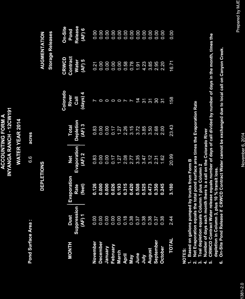
14 Page 13 of 27 (2) East Inyanga Headgate APOD: This headgate is located in the NW1/4 SW1/4, Sec. 13, T. 5 S., R. 90 W., 6th P.M., at a point 1,700 feet from the S. sec. line and 230 feet from the W. sec. line of said Sec. 13, Garfield County, CO. See Figure 2. FOURTH CLAIM FOR RELIEF Confirmation of Decreed Locations With As-built PLSS Locations 18. Confirmation of decreed locations with as-built PLSS locations of decreed water rights. To the extent that the actual/plss location of any of these structures differs from its decreed location, Applicant seeks to amend the decreed locations of each such structure to conform with its actual/plss location. The decreed locations and PLSS locations of these decreed water rights are depicted on Figure 5. A. Rock-N-Pines No. 2 Ditch and Rock-N-Pines No. 2 Ditch Enlargement (1) Case Nos.: C.A (orig); 03CW130 (enlargement) (2) Applicable Locations: (a) (b) (c) Original decreed located in C.A. 4914: On easterly bank of an unnamed tributary of Canyon Creek, whence the SW corner of Sec. 13, T. 5 S., R., 90 W. of the 6th P.M., bears S W feet, Garfield County, CO. Located as decreed in Case No. 03CW130 (enlargement): The headgate is located on an unnamed tributary to Canyon Creek, trib. to the Colo. Riv., in the SW 1/4 NW 1/4 of Sec. 13, T. 5 S., R. 90 W., 6th P.M., at a point whence the SW corner of Sec. 13 bears S W. 3,950 feet, Garfield County, CO. PLSS location: located on an unnamed tributary to Canyon Creek in the SW 1/4 NW 1/4 of Sec. 13, T. 5 S., R. 90 W., 6th P.M.at a point approx. 3,825 feet from the S. sec. line and 600 feet from the W. sec. line of said Sec. 13. (3) Appropriation dates: 06/01/1910 (orig.); 03/12/2003 (enlargement) (4) Adjudication dates: 11/10/1966 (orig.); 12/31/2003 (enlargement) (5) Source: unnamed trib. to Canyon Creek
15 Page 14 of 27 (6) Decreed uses: irrigation and piscatorial (orig.); replacement of evaporative depletions from Rock-N-Pines Pond Nos. 1-9, aesthetic, recreational, and storage in Rock-N-Pines Pond Nos. 1-9 for aesthetic, recreational, piscatorial and augmentation purposes. (7) Decreed amounts: 2.0 c.f.s. (orig.); 2.0 c.f.s. (enlargement) (8) Name and address of owner of land where structure is located: Applicant (9) Historical use: irrigation and pond filling for above-described purposes. B. Baxter No. 2 Ditch and Baxter No. 2 Ditch First Enlargement (see paragraph 16.A. above): (1) Applicable Locations: (a) (b) Decreed Location as changed by W-238: located on the E. bank of Canyon Creek at a point whence the SW corner of Sec. 13, T. 5 S., R. 90 W. of the 6th P.M. bears S W feet. PLSS location: located on the E. bank of Canyon Creek in the NW 1/4 of Sec. 12, T. 5 S., R. 90 W. of the 6th P.M., at a point approximately 2,355 ft. from the N. sec. line and 1,320 ft from the W. sec. line of said Sec. 12. C. Baxter No. 5 Ditch and Baxter No. 5 Ditch First Enlargement (see paragraph 16.B. above): (1) Applicable Locations: (a) (b) Decreed Location as changed by W-240: located on the E. bank of Canyon Creek at a point whence the SW corner of Sec. 13, T. 5 S., R. 90 W. of the 6th P.M. bears S W feet. PLSS location: located on the E. bank of Canyon Creek in the NW 1/4 of Sec. 12, T. 5 S., R. 90 W. of the 6th P.M., at a point approximately 2,355 ft. from the N. sec. line and 1,320 ft from the W. sec. line of said Sec. 12. D. Baxter No. 1 Ditch and Baxter No. 1 Ditch First Enlargement: (1) Case No.: C.A (orig); C.A (first enlargement)
16 Page 15 of 27 (2) Applicable Locations: (a) Decreed Location as changed in W-237: located on the W. bank of Canyon Creek at a point whence the SW corner of Sec. 13, T. 5 S., R. 90 W. of the 6th P.M. bears S W feet. (b) PLSS location: located on the W. bank of Canyon Creek in the SW 1/4 NW 1/4 of Sec. 12., T. 5 S., R. 90 W., 6th P.M. at a point 2,355 feet from the N. sec. line and 1,300 feet from the W. sec. line of said Sec. 12. (3) Appropriation dates: 05/01/1886 (orig); 06/01/1910 (first enlargement) (4) Adjudication dates: 06/07/1906 (orig); 11/10/1966 (first enlargement) (5) Source: Canyon Creek (6) Decreed use: irrigation (7) Decreed amounts: 2.0 c.f.s. (orig.); 6.4 c.f.s. (first enlargement) E. Baxter No. 3 Ditch (1) Case No.: C.A (2) Applicable locations: (a) (b) Decreed location as changed in W-244: located on the W. bank of Canyon Creek at a point whence the SW corner of Sec. 13, T. 5 S., R. 90 W. of the 6th P.M. bears S W feet. PLSS location: located on the W. bank of Canyon Creek in the SW 1/4 NW 1/4 of Sec. 12., T. 5 S., R. 90 W., 6th P.M. at a point 2,355 feet from the N. sec. line and 1,300 feet from the W. sec. line of said Sec. 12. (3) Appropriation date: 06/30/1886 (4) Adjudication date: 06/07/1906 (5) Source: Canyon Creek (6) Decreed use: irrigation (7) Decreed amount: 1.60 c.f.s.
17 Page 16 of 27 F. Baxter No. 4 Ditch (1) Case No.: C.A (2) Applicable locations: (a) (b) Decreed Location as changed in W-241: located on the W. bank of Canyon Creek at a point whence the SW corner of Sec. 13, T. 5 S., R. 90 W. of the 6th P.M. bears S W feet. PLSS location: located on the W. bank of Canyon Creek in the SW 1/4 NW 1/4 of Sec. 12., T. 5 S., R. 90 W., 6th P.M. at a point 2,355 feet from the N. sec. line and 1,300 feet from the W. sec. line of said Sec. 12. (3) Appropriation date: 03/01/1903 (4) Adjudication date: 06/07/1906 (5) Source: Canyon Creek (6) Decreed use: irrigation (7) Decreed amount: 2.0 c.f.s. G. Rock-N-Pines No. 1 Ditch (1) Case No.: C.A (2) Applicable Locations: (a) (b) Decreed Location as changed in W-242: located on the W. bank of Canyon Creek at a point whence the SW corner of Sec. 13, T. 5 S., R. 90 W. of the 6th P.M. bears S W feet. PLSS location: located on the W. bank of Canyon Creek in the SW 1/4 NW 1/4 of Sec. 12., T. 5 S., R. 90 W., 6th P.M. at a point 2,355 feet from the N. sec. line and 1,300 feet from the W. sec. line of said Sec. 12. (3) Appropriation date: 11/11/1958 (4) Adjudication date: 11/10/1966 (5) Source: Canyon Creek
18 Page 17 of 27 (6) Decreed use: irrigation (7) Decreed amount: 3.0 c.f.s. 19. Names of structures to be augmented: FIFTH CLAIM FOR RELIEF Approval of Plan for Augmentation A. Rock-N-Pines Pond Nos. 1-8 described above in Second Claim. B. Rock-N-Pines Pond No. 9 (1) Prior decree information: Case No. 03CW130 Adjudication date: 08/24/2006 Appropriation date: March 12, 2003 (2) Decreed location: In the NW 1/4 SW 1/4 of Sec. 13, T. 5 S., R. 90 W., 6th P.M., Garfield County, CO, at a point 1900 feet from the S. line and 250 feet from the W. line of said Sec. 13. (3) Decreed amount: 2.4 acre-feet (4) Decreed uses: aesthetic, recreational, piscatorial, and augmentation 20. Water Rights to be Used for Augmentation: Applicant has entered into a water supply contract with the River District for 16.8 acrefeet of replacement water from any one or a combination of the following sources: A. Wolford Mountain Reservoir. The River District owns and operates Wolford Mountain Reservoir (f/k/a Gunsight Pass Reservoir) which has the following water rights. (1) Case No. 87CW283: Decree Date: November 20, 1989 Legal description of place of storage: The dam is located in the SW1/4 of the NE1/4 of Section 25, T. 2 N., R. 81 W., 6th P.M. The intersection of the dam axis with the right abutment will occur at a point which bears S '20" E. a distance of 3, feet from the NW Corner of said Section 25.
19 Page 18 of 27 Source: Muddy Creek and its tributaries Amount: 59,993 acre-feet conditional; of this amount, 32,986 acre-feet were made absolute for piscatorial and recreational uses by decree entered in Water Court Case No. 95CW251, and the full amount was made absolute for all purposes by decree entered in Water Court Case No. 02CW107. Appropriation Date: December 14, 1987 Use: All beneficial uses, including but not limited to domestic, municipal, agricultural and recreational uses, which uses satisfy the requirements of the Windy Gap Settlement made with the Municipal Subdistrict of the Northern Colorado Water Conservancy District; use to meet the water requirements of the inhabitants of the River District for all uses, including uses in the Middle Park area; and use to meet the terms of a lease agreement executed March 3, 1987 between the River District and the City and County of Denver. (2) Case No. 95CW281: Decree Date: August 26, 1997 Legal description of place of storage: The dam is located in the SW1/4 of the NE1/4 of Section 25, T. 2 N., R. 81 W., 6th P.M. The as-built intersection of the dam axis (Sta. D ) with the West Access Road (Sta. WR ), as shown on the CRWCD, Wolford Mountain Project, Ritschard Dam construction drawing "Dimensional Dam Layout" sheet 8 of 94, occurs at a point which bears S '56" E. a distance of 3, feet from the NW Corner of said Section 25; the bearing of said dam axis from Sta to Sta being S ' 29" E. Source: Muddy Creek and its tributaries Amount: 6,000 acre-feet conditional Appropriation Date: January 16, 1995 Use: All beneficial uses by and for the benefit of the inhabitants of the CRWCD, including but not limited to domestic, municipal, industrial, irrigation, agricultural, piscatorial and recreational; such uses will include environmental mitigation, including environmental mitigation requirements associated with the Wolford Mountain Project; such uses will be made directly or by substitution, augmentation, or exchange. None of the water stored in the exercise of the right will be delivered directly or by exchange, substitution, or otherwise for use outside of Colorado Water Division No. 5. (3) Case No. 98CW237: Decree Date: July 6, Legal Description of place of storage: Same as for 95CW281.
20 Page 19 of 27 Source: Muddy Creek and its tributaries Amount: 30,000 acre-feet conditional with 15,895 acre-feet being absolute for recreational and piscatorial and flood control. Appropriation Date: November 17, 1998 Use: Certain of the beneficial uses previously adjudicated for Wolford Mountain Reservoir in Case No. 87CW283, District Court for Colorado Water Division No. 5 (November 20, 1989 Judgment and Decree), and Case No. 95CW281, District Court for Colorado Water Division No. 5 (August 26, 1997 Judgment and Decree). 87CW283: The reservoir will be used to satisfy the requirements of the Windy Gap Settlement made with the Municipal Subdistrict of the Northern Colorado Water Conservancy District. This will involve all uses, including but not limited to domestic, municipal, agricultural, and recreational uses. The reservoir will also be used to meet the water requirements of the inhabitants of the River District for all uses, including uses in the Middle Park area. 95CW281: All beneficial uses by and for the benefit of the inhabitants of the CRWCD, including but not limited to domestic, municipal, industrial, irrigation, agricultural, piscatorial and recreational; such uses will include environmental mitigation, including environmental mitigation requirements associated with the Wolford Mountain Reservoir Project; such uses will be made directly or by substitution, augmentation, or exchange. Remarks: The Refill Right described herein will be exercised to provide supply for the Western Slope uses of water from Wolford Mountain Reservoir described above, including flood control, other operational purposes, and environmental mitigation and enhancement for the benefit of uses within the District. The Refill Right will not be used in conjunction with the Reservoir capacity (24,000 a.f.) which is allocated for the supply of water to the Denver Board of Water Commissioners under Applicant's contractual relationship with Denver, or the Reservoir capacity (6,000 AF) which is allocated for Colorado River endangered fish releases. B. Ruedi Reservoir. The River District holds Contracts No. 009D6C0111, 009D6C0118, and 039F6C0011 from the United States Bureau of Reclamation for 1,730 acre-feet of annual supply from Ruedi Reservoir and may obtain additional contracts in the future. This water will be used in addition to and substitution for Wolford Mountain Reservoir water in appropriate circumstances where Ruedi water is physically equivalent to Wolford water.
21 Page 20 of 27 (1) Legal description of place of storage: Ruedi Reservoir is located in Sections 7, 8, 9, 11 and 14 through 18, T. 8 S., R. 84 W., 6th P.M., in Eagle and Pitkin Counties. The dam axis intersects the right abutment at a point whence the SW corner of Section 7, T. 8 S., R. 84 W. of the 6th P.M. bears N 'W. a distance of 1,285 feet. (2) Source: Fryingpan River. (3) Previous storage decrees: (a) Civil Action No. 4613: Decree Date: June 20, Court: Garfield County District Court. Amount: 140,697.3 acre-feet, reduced to 102,369 acre-feet pursuant to order of the Water Court in Case No. W The full amount was made absolute in Case No. 88CW85. Appropriation Date: July 29, Use: Domestic, municipal, irrigation, industrial, generation of electrical energy, stock watering and piscatorial. (b) 21. Statement of Plan for Augmentation. Case No. 81CW34: Decree Date: April 8, Court: District Court, Water Div. No. 5. Amount: 101,280 acre-feet (refill); of this amount, 44,509 acre-feet were made absolute in Case No. 95CW95 and 25,257 acre-feet were made absolute in Case No. 01CW269, for a total of 69,766 acre-feet absolute. Appropriation Date: Jan. 22, Use: Irrigation, domestic, municipal, generation of electrical energy, stock watering, industrial, piscatorial, recreation and maintenance of sufficient storage reserves to fulfill contractual obligations and provide stored water for recreation in times of drought. A. Summary of Plan. Applicant proposes to augment depletions due to pond evaporation and dust control upon Inyanga Ranch against downstream calls from Colorado River water rights with water released from Wolford Mountain Reservoir or Ruedi Reservoir pursuant to a contract with the River District. Use of the River District contract water in the plan for augmentation described herein is conditioned on the existence of a valid contract between the Applicant (or its successor) and the River District.
22 Page 21 of 27 B. Depletions. The total potential surface area of the Rock-N-Pines Pond Nos. 1-9, inclusive, is 6.6 acres, including the surface area of associated ditches, channels and ponded spring areas. The annual evaporation rate from these ponds is calculated at 3.18 acre-feet per acre. The total annual evaporation from 6.6 acres is therefore acre-feet. Dust control is estimated to require 8000 gallons per day every other day from mid-april through October for a total of 2.44 acre-feet per year. For purposes of this plan for augmentation, evaporation and dust control are both assumed to be 100% depletive. The projected maximum annual evaporation from the combined surface area of these ponds, plus the amount of water from these structures that may be consumptively used for dust control purposes, is acre-feet per year. As set forth on the attached Table 1, a substantial amount of this consumptive use occurs during the summer irrigation season when there is potential for a downstream water rights call on the Colorado River, which is sometimes referred to as the Cameo call. C. Operation. The proposed plan for augmentation will allow Applicant to replace evaporation from Pond Nos. 1-9, and depletions related to dust suppression, whenever there is a downstream call on the Colorado River, but no call on Canyon Creek. During such periods, water will be released from either Wolford Reservoir or Ruedi Reservoir pursuant to the 16.8 acre-foot water supply contract described above as needed to replace out-of-priority depletions to the Colorado River system below Canyon Creek. However, during any periods when Canyon Creek is under administration due to a local call, Applicant will: (1) continue to either make releases to Canyon Creek from Pond No. 9 to replace evaporation from the surface of Pond Nos. 1-8 pursuant to the plan for augmentation approved in Case No. 03CW130, or discontinue any additional storage in all nine ponds and (2) cease use of water for dust control, as required to avoid injury to vested water rights downstream on Canyon Creek. SIXTH CLAIM FOR RELIEF Appropriative Right of Exchange 22. Inyanga Canyon Creek Exchange No. 1. A. Downstream terminus: confluence of Canyon Creek and the Colorado River, located in the NW ¼, NW ¼, Sec. 36, T. 5 S., R. 90 W. of the 6 th P.M., Garfield County, CO, at a point approx ft. from the S. sec. line and1050ft. from the W. sec. line. See Figure 6. B. Upstream terminus: Rock-N-Pines Ditch No. 2, described above. See Figure 6. C. Max. Rate of Exchange: 0.07 c.f.s., conditional (maximum of 16.8 acre-feet annually).
23 Page 22 of 27 D. Appropriation: (1) Appropriation date: December 31, 2012 (2) How appropriation was initiated: by field surveys, engineering studies, formation of the necessary intent, and performance of overt acts necessary to put interested parties on notice, including without limitation the filing of this application. E. Uses: Augmentation. F. Remarks: this exchange will operate in conjunction with the plan for augmentation described above in Applicant s Fifth Claim. CONCLUSIONS OF LAW 23. The foregoing Findings of Fact are fully incorporated herein by this reference. 24. The Application is complete, covering all applicable matters required pursuant to the Water Right Determination and Administration Act of C.R.S Timely and adequate notice of the Application was given in the manner required by law. 26. The Application is one contemplated by law and this Court has jurisdiction over the Application and over all entities or persons who had standing to appear, whether or not they appeared, and the Referee may enter this Ruling. 27. The requested changes of water rights and plan for augmentation including exchange, subject to the terms and conditions set forth in this decree, will not injuriously affect the owner of or persons entitled to use water under a vested water right or decreed conditional water right. See C.R.S (3) and 305(8). The following additional terms and conditions are imposed upon the changes of water rights and plan for augmentation approved herein so as to further protect other vested water rights from injury: A. During any downstream call when the senior water rights for the Baxter No. 2 Ditch and the Baxter No. 5 Ditch remain in priority, Applicant s use of the Baxter No. 2 Ditch and the Baxter No. 5 ditch water rights shall be limited to irrigation of no more than 48 acres in the areas shown on Figure 4. B. Applicant may clean out or deepen Rock-N-Pines Pond Nos. 1-8, but shall not enlarge the surface areas of these structures unless the plans for augmentation described in this decree and in the final decree in Case No. 03CW130 are first amended by the Water Court to account for any increase in potential evaporative losses.
24 Page 23 of Applicant has established that the conditional water rights claimed in this decree can and will be diverted, stored, or otherwise captured, possessed and controlled and will be beneficially used and that the project can and will be completed with diligence and within a reasonable time. See C.R.S (9)(b). RULING OF THE REFEREE 29. The foregoing Findings of Fact and Conclusions of Law as set forth above are incorporated herein by reference. 30. Applicant s first claim is granted; therefore, a conditional surface water right is hereby confirmed for the Inyanga Hydropower Pipeline for the purpose of hydro-electric power generation in the amounts of 4.0 c.f.s. during the irrigation season each year, from April 1 through October 31, and 2.0 c.f.s. outside of the irrigation season each year, from November 1 to March 31, as more thoroughly described in paragraph Applicant s second claim is granted; therefore, conditional water storage rights are hereby confirmed for the Rock-N-Pines Pond Nos. 1-8, in the amounts and for the purposes described above in paragraphs 8 through Applicant s third claim for the change of water rights described above in paragraphs is hereby granted, subject to the terms and conditions of this decree. (Applicant has withdrawn its claim to change its existing senior irrigation water rights to add a hydroelectric power generation as a decreed use). 33. Applicant s fourth claim for the change of water rights described above in paragraph 18 is hereby granted, subject to the terms and conditions of this decree. A. The decreed location for the Rock-N-Pines No. 2 Ditch and Rock-N-Pines No. 2 Ditch Enlargement is as follows: located on an unnamed tributary to Canyon Creek in the SW 1/4 NW 1/4 of Sec. 13, T. 5 S., R. 90 W., 6th P.M.at a point approx. 3,825 feet from the S. sec. line and 600 feet from the W. sec. line of said Sec. 13. B. The decreed location for the Baxter No. 2 Ditch and Baxter No. 2 Ditch First Enlargement and the Baxter No. 5 Ditch and Baxter No. 5 Ditch First Enlargement is as follows: located on the E. bank of Canyon Creek in the NW 1/4 of Sec. 12, T. 5 S., R. 90 W. of the 6th P.M., at a point approximately 2,355 ft. from the N. sec. line and 1,320 ft from the W. sec. line of said Sec. 12. C. The decreed location for the Baxter No. 1 Ditch and Baxter No. 1 Ditch First Enlargement, Baxter No. 3 Ditch, Baxter No. 4 Ditch, and the Rock-N-Pines No. 1 Ditch is as follows: located on the W. bank of Canyon Creek in the SW
25 Page 24 of 27 1/4 NW 1/4 of Sec. 12., T. 5 S., R. 90 W., 6th P.M. at a point 2,355 feet from the N. sec. line and 1,300 feet from the W. sec. line of said Sec Applicant s fifth claim is approved, and the plan for augmentation described above in paragraphs is hereby approved, subject to the terms and conditions of this decree. 35. Applicant s sixth claim is granted, and a conditional appropriative right of exchange is hereby granted for the Inyanga Canyon Creek Exchange No. 1, in the amounts and for the uses described above in paragraph The water rights, changes of water rights, and plan for augmentation including exchange are administrable by the officials of the State of Colorado. Pursuant to C.R.S (8), the State Engineer shall curtail any out-of-priority diversions, the depletions from which are not so replaced as to prevent injury to vested water rights. 37. The Court shall retain jurisdiction over the changes of water rights and plan for augmentation decreed herein pursuant to C.R.S (6) for reconsideration of injury to the vested rights of others for a period starting at the date of the decree and continuing until five years after the Applicant provides written notice to the Division Engineer, the Objectors (via U.S. mail to the last address for each Objectors on file with the Court in this proceeding) and the Court that the plan for augmentation has been operated, and the Division Engineer has received an as-built and a stage capacity curve for Rock-N-Pines Pond No Applicant shall provide notice to the Division Engineer prior to commencing operation of the exchange for the first time. 39. Applicant shall develop adequate accounting to prevent injury to the vested water rights of others and assist in the proper administration of the plan for augmentation, including exchange granted in this ruling. Applicant shall maintain proper accounting, and shall provide the same to the Division 5 Engineer on at least an annual basis or as necessary for the proper administration of the plan for augmentation, including exchange granted in this ruling to prevent injury to other water rights. 40. Applicant shall be responsible for any reporting and accounting under the plan for augmentation approved in this ruling. Applicant shall notify the Division 5 Engineer s Office of any subsequent changes in the responsible entity under this plan. A sample accounting form is attached as Exhibit A. 41. Parts of this decree are the result of negotiations and settlement discussions between the parties. Its terms are based on the specific facts and circumstances of this case. By stipulating to the entry of this decree, no party in this case intends that it become a precedent to resolve issues in any other case.
26 Page 25 of The conditional water rights confirmed herein for the Inyanga Hydropower Pipeline, Rock-N-Pines Pond Nos. 1-8, and the Inyanga Canyon Creek Exchange No. 1 were filed in the Water Court in 2012, shall be administered as having been filed in that year, and shall be junior to all priorities filed in previous years. As between water rights filed in the same calendar year, priority shall be determined by the dates of appropriation for the water rights, and shall not be affected by the dates of entry of the decrees. 43. Should the Applicant desire to maintain the conditional water rights described in this decree, an Application for Finding of Reasonable Diligence shall be filed in the same month six years from the date of the water judge s order set forth below, unless a determination has been made prior to that date that such conditional rights have been made absolute by reason of the completion of the appropriation or are otherwise disposed. 44. All of the water rights granted in this decree are part of an integrated water supply system providing water to Inyanga Ranch for the purposes of future reasonable diligence findings. Diligence with respect to any one component of the system shall be appropriately considered in finding that reasonable diligence has been shown in the development of water rights for all features of Applicant s integrated water supply system. 45. Pursuant to Rule 9 of the Uniform Local Rules for All State Water Court Divisions, upon the sale or other transfer of the conditional water right decreed herein, the transferee shall file with the Division 5 Water Court a notice of transfer that shall state: A. The title and case number of this ; B. The description of the conditional water right transferred; C. The name of the transferor; D. The name and mailing address of the transferee; and E. A copy of the recorded deed. The owner of said conditional water right shall also notify the Clerk of the Division 5 Water Court of any change in mailing address. The Clerk shall place any notice of transfer or change of address in the case file of this and in the case file (if any) in which the Court first made a finding of reasonable diligence. It is accordingly ORDERED that this Judgment and Decree shall be filed with the Water Clerk and shall become effective upon such filing, subject to judicial review pursuant to C.R.S , as amended. It is FURTHER ORDERED that a copy of this Judgment and Decree shall be filed with the State Engineer and the Division Engineer for Water Division No. 5.
27 Page 26 of 27 Done this 20th day of August, BY THE REFEREE Water Referee Water Division No. 5 State of Colorado
28 Page 27 of 27 JUDGMENT AND DECREE OF THE WATER COURT No protest was filed in this matter, and accordingly, the foregoing Ruling is confirmed and approved, and is made the Judgment and Decree of this Court _24 BY THE COURT: Water Judge Water Division No. 5 State of Colorado
29 Approximate Property Boundary Rock-N-Pines No. 2 Ditch and Enlargement Actual Location!( Rock-N-Pines Pond No. 1 Rock-N-Pines Pond No. 2 Rock-N-Pines Pond No. 3 Rock-N-Pines Pond No. 4 Rock-N-Pines Pond No. 6 Rock-N-Pines Pond No. 7 Rock-N-Pines Pond No. 9 Canyon Creek Rock-N-Pines Pond No. 5 Rock-N-Pines Pond No. 8 T5S R90W Source: Storm King Mountain and Adams Lake Quadrangles Figure 1: Lower Ranch Ponds Water Rights Location Map Inyanga Ranch, LLC RESOURCE E N G I N E E R I N G, I N C. 909 Colorado Avenue / Glenwood Springs, CO Voice: (970) Web: ,000 2,000 1 in = 1,000 ft Feet Date: 04/08/2015 File: Drawn: RKM Approved: MJE
30 Current Decreed Points of Diversion on the West Baxter No. 1 Ditch, Baxter No. 1 Ditch First Enlargement Baxter No. 2 Ditch, Baxter No. 2 Ditch First Enlargement Baxter No. 3 Ditch Baxter No. 4 Ditch Baxter No. 5 Ditch, Baxter No. 5 Ditch First Enlargement Rock-N-Pines No. 1 Ditch Inyanga Hyrdopower Pipeline Current Decreed Points of Diversion on the East Baxter No. 2 Ditch, Baxter No. 2 Ditch First Enlargement Baxter No. 5 Ditch, Baxter No. 5 Ditch First Enlargement! ( W C Canyon Creek Approximate Property Boundary r o t t n e m h c a t t A e d r O East Inyanga Headgate -APOD for Baxter No. 2 Ditch, Baxter No. 2 Ditch First Enlargement Baxter No. 5 Ditch, Baxter No. 5 Ditch First Enlargement Location of Inyanga Hydropower Pipeline Return Flow within this Reach of Canyon Creek above the Williams Canal. T5S R90W Source: Storm King Mountain and Adams Lake Quadrangles RESOURCE E N G I N E E R I N G, I N C. 909 Colorado Avenue / Glenwood Springs, CO Voice: (970) Web: Figure 2: Water Rights Location Map Inyanga Ranch, LLC ,500 1 in = 1,500 ft 3,000 Feet Date: 04/08/2015 File: Drawn: RKM Approved: MJE
31 34.2 acres Irrigated 1883-Present 22.8 acres Irrigated T5S R90W 57.0 Total acres Irrigated Source: Storm King Mountain and Adams Lake Quadrangle RESOURCE E N G I N E E R I N G, I N C. 909 Colorado Avenue / Glenwood Springs, CO Voice: (970) Web: Figure 3: Historic Irrigation for the Baxter No. 2 Ditch and Baxter No. 5 Ditch, Inyanga Ranch, LLC ,600 1 in = 800 ft Feet Date: 04/08/2015 File: Drawn: RKM Approved: MJE
32 Proposed Location of 48 acres of Irrigation T5S R90W Source: Storm King Mountain and Adams Lake Quadrangle Figure 4: Proposed Location of 48 acres of Irrigation from Alternate Point(s) of Diversion for the Baxter No. 2 Ditch and Baxter No. 5 Ditch, Inyanga Ranch, LLC RESOURCE E N G I N E E R I N G, I N C. 909 Colorado Avenue / Glenwood Springs, CO Voice: (970) Web: ,600 1 in = 800 ft Feet Date: 04/08/2015 File: Drawn: RKM Approved: MJE
33 Baxter No. 2 Ditch, Baxter No. 2 Ditch First Enlargement Baxter No. 5 Ditch, Baxter No. 5 Ditch First Enlargement 170 feet between actual and decreed locations Legal: Legal: PLSS PLSS based based on on BLM BLM Section Lines Lines #!( Baxter No. 1 Ditch, Baxter No. 1 Ditch First Enlargement Baxter No. 3 Ditch Baxter No. 4 Ditch Rock-N-Pines No. 1 Ditch 171 feet between actual and decreed locations Legal: Legal: PLSS PLSS based based on BLM on BLM Section Section Lines Lines Rock-N-Pines No. 2 Ditch, Enlargement (Corrected Decreed Location 03CW130) 226 feet between actual and decreed locations Legal: PLSS based on BLM Section Lines Rock-N-Pines No. 2 Ditch (Original Decreed Location CA4914) 1178 feet between actual and decreed locations Legal: PLSS based on BLM Section Lines # #!( Rock-N-Pines No. 2 Ditch and Enlargement (Actual Point of Diversion) T5S R90W Background: Adams Lake and Storm King Mt. Quadrangles RESOURCE E N G I N E E R I N G, I N C. 909 Colorado Avenue / Glenwood Springs, CO Voice: (970) Web: Figure 5: Water Rights Location Map, 12CW191 Actual and Decreed Locations Comparison Inyanga Ranch, LLC ,800 1 in = 900 ft Feet!( Actual Location # Decreed Location Date: 04/08/2015 File: Drawn: RKM Approved: MJE
34 ! ( Upstream Terminus Rock-N-Pines Ditch No. 2 n nyo Ca Creek r o t t n e m h c a t t A e d r O W C Downstream Terminus Confluence of Canyon Creek and Colorado River! ( T5S R90W Source: Storm King Mountain Quadrangle RESOURCE E N G I N E E R I N G, I N C. 909 Colorado Avenue / Glenwood Springs, CO Voice: (970) Web: Figure 6: Exchange Reach Location Map Inyanga Ranch, LLC 0 1,000 2,000 1 in = 2,000 ft 4,000 Feet Date: 04/08/2015 File: Drawn: RKM Approved: MJE
35 Table 1 Augmentation Plan Depletions and Replacement, Inyanga Ranch, LLC Evaporation Total Dust Total Colorado River Out-of-Priority Contract Storage Month Rate Evaporation Control Depletions Call Depletions Releases (feet) (acre-feet) (acre-feet) (acre-feet) (days) (acre-feet) (acre-feet) (1) (2) (3) (4) (5) (6) (7) Jan Feb Mar Apr May Jun Jul Aug Sep Oct Nov Dec Total Notes: (1) Evaporation based on 42 inches gross evaporation and ice cover from December through early February (2) Column 1 multiplied by 6.6 acres of pond and channel surface area (3) Estimated at 8,000 gallons of water every other day from mid April-October (4) Column (2) plus Column (3) (5) Cameo Call is expected to last 7 days in April, 7 days in May, 14 days in June and July 1st through November 7th (6) Depletions from Column (4) when call is on in Column (5) (7) Contract storage releases when Colorado River Call is on, Equals Column (6) plus 10% transit loss /1/2014 Prepared by RKM Approved by MJE
36 Table 2 Historic Consumptive Use, Inyanga Ranch, LLC Irrigation Historic Historic Historic Total Average Water Consumptive Consumptive Use Consumptive Use Historic Historic Month Requirement Use Rate for 57.0 acres for 34.2 acres Consumptive Use Consumptive Use Present 1903-Present 1903-Present (feet) (feet) (acre feet) (acre feet) (acre feet) (acre feet) (1) (2) (3) (4) (5) (6) Jan Feb Mar Apr May Jun Jul Aug Sep Oct Nov Dec Total Notes: 1) Irrigation Water Requirement calculated using StateCU 2) Historic Consumptive Use Rate calculated using StateCU 3) Historic Consumptive Use based on 57.0 acres of irrigation from , 68 years multiplied by 57.0 acres multiplied by Column (2) 4) Historic Consumptive Use based on 34.2 acres of irrigation from 1971-Present, 42 years multiplied by 34.2 acres multiplied by Column (2) 5) Column (3) plus Column (4) 6) Column (5) divided by entire irrigation period (110 years) CW191 6/4/2015 Prepared by RKM Approved by MJE
37
38
DIVISION 5 WATER COURT- SEPTEMBER 2017 RESUME
 DIVISION 5 WATER COURT- SEPTEMBER 2017 RESUME 1. PURSUANT TO C.R.S., 37-92-302, AS AMENDED, YOU ARE NOTIFIED THAT THE FOLLOWING PAGES CLERK FOR DURING THE MONTH OF SEPTEMBER 2017. The water right claimed
CASE NO. 01CW1 TOM SMITH, P. O.
 DISTRICT COURT, WATER DIVISION NO. 2, COLORADO FEBRUARY 2001 RESUME (Cases filed during January 2001) TO: ALL INTERESTED PARTIES Pursuant to C.R.S. 37-92-302, you are hereby notified that the following
DISTRICT COURT, WATER DIV. 6, COLORADO TO ALL PERSONS INTERESTED IN WATER APPLICATIONS IN WATER DIV. 6
 DISTRICT COURT, ATER DIV. 6, COLORADO TO ALL PERSONS INTERESTED IN ATER APPLICATIONS IN ATER DIV. 6 Pursuant to C.R.S. 37-02-302, you are hereby notified that the following pages comprise a resume of Applications
DISTRICT COURT, WATER DIVISION NO. 2, COLORADO
 DISTRICT COURT, WATER DIVISION NO. 2, COLORADO RESUME OF CASES FILED AND/OR ORDERED PUBLISHED DURING JUNE 2018 TO: ALL INTERESTED PARTIES Pursuant to C.R.S. 37-92-302, you are hereby notified that the
SUPREME COURT OF THE UNITED STATES
 OCTOBER TERM, 2001 1 Decree SUPREME COURT OF THE UNITED STATES No. 108, Orig. STATE OF NEBRASKA, PLAINTIFF v. STATES OF WYOMING AND COLORADO ON PETITION FOR ORDER ENFORCING DECREE AND FOR INJUNCTIVE RELIEF
District Court, Water Division 1, State of Colorado The Honorable Todd Taylor Case No.: 15CW3026
 SUPREME COURT, STATE OF COLORADO 2 East 14th Avenue Denver, Colorado 80203 District Court, Water Division 1, State of Colorado The Honorable Todd Taylor Case No.: 15CW3026 Defendant-Appellant: K-LOW, LLC,
Green Mountain Reservoir Administrative Protocol Agreement
 THIS AGREEMENT is made and entered into as of the effective date (as defined in paragraph 17 below), by and among the United States of America ( United States ), the City and County of Denver, acting by
Produced Nontributary Ground Water Notification List
 IN THE DISTRICT COURT IN AND FOR WATER DIVISION NO. 4 STATE OF COLORADO TO: ALL PERSONS INTERESTED IN WATER APPLICATIONS IN SAID WATER DIVISION NO. 4 Pursuant to C.R.S. 37-92-302, as amended, you are notified
NON-ATTORNEY S GUIDE TO COLORADO WATER COURTS
 NON-ATTORNEY S GUIDE TO COLORADO WATER COURTS INTRODUCTION The purpose of this guide is to assist you through the most common water court processes. These processes include applying for a water right and
GUNNISON COUNTY. CASE NO. 2015CW12 (REF NO. 03CW267).
.") IN THE DISTRICT COURT IN AND FOR WATER DIVISION NO. 4 STATE OF COLORADO TO: ALL PERSONS INTERESTED IN WATER APPLICATIONS IN SAID WATER DIVISION NO. 4 Pursuant to C.R.S. 37-92-302, as amended, you are notified
IN THE DISTRICT COURT IN AND FOR WATER DIVISION NO. 4 STATE OF COLORADO TO: ALL PERSONS INTERESTED IN WATER APPLICATIONS IN SAID WATER DIVISION NO. 4 Pursuant to C.R.S. 37-92-302, as amended, you are notified
FINDINGS OF FACT, CONCLUSIONS OF LAW AND JUDGMENT AND DECREE OF THE WATER COURT
 District Court, Water Division No. 1, State of Colorado 901 Ninth Avenue, P.O. Box 2038 Greeley, Co 80632-2038 (970) 351-7300 CONCERNING THE APPLICATION OF: UPPER SOUTH PLATTE WATER CONSERVANCY DISTRICT
TO: ALL PERSONS INTERESTED IN WATER APPLICATIONS IN SAID WATER DIVISION NO. 7
 DISTRICT COURT, WATER DIVISION 7, COLORADO WATER RESUME TO: ALL PERSONS INTERESTED IN WATER APPLICATIONS IN SAID WATER DIVISION NO. 7 Pursuant to C.R.S. 37-92-302, you are notified that the following is
Idaho Water Law: Water Rights Primer & Definitions. A. What is a Water Right?
 Idaho Water Law: Water Rights Primer & Definitions DISCLAIMER: This information was created by and is attributable to IDWR. It is provided through the Law Office of Arthur B. for your adjudication circumstances
Vague and Ambiguous. The terms market and marketing are not defined.as such, the
 (c) (d) Not Directed to All Settling Parties. This discovery request was directed to all three Settling Parties (the United States, the Navajo Nation, and the State of New Mexico) requesting information
Congressional Record -- Senate. Thursday, October 8, 1992 (Legislative day of Wednesday, September 30, 1992) 102nd Cong. 2nd Sess.
 102nd Cong. 2nd Sess.") REFERENCE: Vol. 138 No. 144 Congressional Record -- Senate Thursday, October 8, 1992 (Legislative day of Wednesday, September 30, 1992) TITLE: COLORADO WILDERNESS ACT; WIRTH AMENDMENT NO. 3441 102nd Cong.
REFERENCE: Vol. 138 No. 144 Congressional Record -- Senate Thursday, October 8, 1992 (Legislative day of Wednesday, September 30, 1992) TITLE: COLORADO WILDERNESS ACT; WIRTH AMENDMENT NO. 3441 102nd Cong.
[Draft] [Intergovernmental Agreement]
![[Draft] [Intergovernmental Agreement]](/thumbs/71/66126013.jpg "[Draft] [Intergovernmental Agreement]") [Draft] [Intergovernmental Agreement] The Municipal Subdistrict, Northern Colorado Water Conservancy District and its Windy Gap Firming Project Water Activity Enterprise, Board of County Commissioners
[Draft] [Intergovernmental Agreement] The Municipal Subdistrict, Northern Colorado Water Conservancy District and its Windy Gap Firming Project Water Activity Enterprise, Board of County Commissioners
2016 CO 42. The Upper Eagle Regional Water Authority filed an application to make absolute
 Opinions of the Colorado Supreme Court are available to the public and can be accessed through the Judicial Branch s homepage at http://www.courts.state.co.us. Opinions are also posted on the Colorado
The supreme court affirms an order of the district court. for Water Division No. 1, holding that an application for a
 Opinions of the Colorado Supreme Court are available to the public and can be accessed through the Court s homepage at http://www.courts.state.co.us and are posted on the Colorado Bar Association homepage
SAN JUAN RIVER BASIN IN NEW MEXICO NAVAJO NATION WATER RIGHTS SETTLEMENT AGREEMENT
 SAN JUAN RIVER BASIN IN NEW MEXICO NAVAJO NATION WATER RIGHTS SETTLEMENT AGREEMENT This Agreement is entered into as of the dates executed below, by and among the State of New Mexico, the Navajo Nation
Arkansas River Compact Kansas-Colorado 1949 ARKANSAS RIVER COMPACT
 Arkansas River Compact Kansas-Colorado 1949 K.S.A. 82a-520. Arkansas river compact. The legislature hereby ratifies the compact, designated as the "Arkansas river compact," between the states of Colorado
STATE AND DIVISION ENGINEERS MOTION FOR JOINDER
 DISTRICT COURT, WATER DIVISION NO.1 WELD COUNTY, COLORADO 901 9 th Avenue / P.O. Box 2038 Greeley, Colorado 80631 (970) 351-7300 PLAINTIFF, The Jim Hutton Educational Foundation, v. DEFENDANTS, Dick Wolfe,
One Hundred Fourteenth Congress of the United States of America
 S. 612 One Hundred Fourteenth Congress of the United States of America AT THE SECOND SESSION Begun and held at the City of Washington on Monday, the fourth day of January, two thousand and sixteen An Act
THE COLORADO RULES OF CIVIL PROCEDURE FOR COURTS OF RECORD IN COLORADO CHAPTER 10 GENERAL PROVISIONS
 THE COLORADO RULES OF CIVIL PROCEDURE FOR COURTS OF RECORD IN COLORADO CHAPTER 10 GENERAL PROVISIONS RULE 86. PENDING WATER ADJUDICATIONS UNDER 1943 ACT In any water adjudication under the provisions of
DOCKET NO. D CP-3 DELAWARE RIVER BASIN COMMISSION. Drainage Area to Special Protection Waters
 DOCKET NO. D-2001-038 CP-3 DELAWARE RIVER BASIN COMMISSION Drainage Area to Special Protection Waters Eagle Creek Hydro Power, LLC Toronto, Cliff Lake, & Swinging Bridge Hydroelectric Dam System Towns
2017 CO 43. This appeal from the water court in Water Division No. 1 concerns the nature and
 Opinions of the Colorado Supreme Court are available to the public and can be accessed through the Judicial Branch s homepage at http://www.courts.state.co.us. Opinions are also posted on the Colorado
1. "Bear River" means the Bear River and its tributaries from its source in the Uinta Mountains to its mouth in Great Salt Lake;
 Ratification and approval is hereby given to the Bear River Compact as signed at Salt Lake City, in the state of Utah, on the 22nd day of December, A.D., 1978, by George L. Christopulos, the state engineer
The Colorado Supreme Court affirms the water court s. determination that the City and County of Broomfield s
 Opinions of the Colorado Supreme Court are available to the public and can be accessed through the Court s homepage at http://www.courts.state.co.us and are posted on the Colorado Bar Association homepage
WYOMING S COMPACTS, TREATIES AND COURT DECREES
 DOCUMENTS ON THE USE AND CONTROL OF WYOMING S INTERSTATE STREAMS WYOMING S COMPACTS, TREATIES AND COURT DECREES Compiled by the Interstate Streams Division Wyoming State Engineer s Office Website: http://seo.state.wy.us
IN THE OFFICE OF ADMINISTRATIVE HEARINGS STATE OF ARIZONA
 0 0 Keith L. Hendricks, Bar No. 00 Joshua T. Greer, Bar No. 00 0 N. Central Avenue, Suite 00 Phoenix, AZ 00 KHendricks@law-msh.com Telephone: 0.0.0 Douglas C. Nelson, Bar No. 00 LAW OFFICE OF DOUGLAS C.
or so much of such amount as constitutes three-fourths of
 f INTERNATIONAL JOINT COMMISSION ORDER 4 October, 1921 In The Matter of the Measurement and Apportionment of the Waters of the St. Mary and Milk Rivers and Their Tributaries in the State of Montana and
A Practitioner s Guide to Instream Flow Transactions in California
 A Practitioner s Guide to Instream Flow Transactions in California Appendix A Forbearance Agreement Examples Agreement for the Forbearance of Water for Fisheries Enhancement in the ---------- River System,
STATE ENGINEER S OFFICE STATE OF WYOMING PART II GROUND WATER
 R E G U L A T I O N S A N D I N S T R U C T I O N S STATE ENGINEER S OFFICE STATE OF WYOMING PART II GROUND WATER CHEYENNE, WYOMING REVISED JANUARY 1974 Rules and Regulations STATE ENGINEER S OFFICE State
In this water rights dispute, the Supreme Court holds that. section , C.R.S. (2005), requires the City of Central
, requires the City of Central") Opinions of the Colorado Supreme Court are available to the public and can be accessed through the Court s homepage at http://www.courts.state.co.us/supct/supctcaseannctsindex.htm and are posted on the
Opinions of the Colorado Supreme Court are available to the public and can be accessed through the Court s homepage at http://www.courts.state.co.us/supct/supctcaseannctsindex.htm and are posted on the
New Mexico Water Law Case Capsules 2-1
 Water Matters! New Mexico Water Law Case Capsules 2-1 New Mexico Water Law Case Capsules New Mexico has a rich body of water law. This list contains some of the key cases decided in the state and federal
CHIPPEWA CREE TRIBE OF THE ROCKY BOY S RESERVATION INDIAN RESERVED WATER RIGHTS SETTLEMENT AND WATER SUPPLY ENHANCEMENT ACT OF 1999
 CHIPPEWA CREE TRIBE OF THE ROCKY BOY S RESERVATION INDIAN RESERVED WATER RIGHTS SETTLEMENT AND WATER SUPPLY ENHANCEMENT ACT OF 1999 VerDate 04-JAN-2000 18:14 Jan 07, 2000 Jkt 079139 PO 00163 Frm 00001
In The Supreme Court of the United States
 No. 22O141, Original ================================================================ In The Supreme Court of the United States --------------------------------- --------------------------------- STATE
MEMO INFORMATION, MINERALS PROGRAM. DATE: October 2, 2001 Revised October 19, 2001, August 2, 2004, and January 12, 2006
 MEMO INFORMATION, MINERALS PROGRAM TO: FROM: Whom It May Concern The Division of Reclamation, Mining and Safety DATE: October 2, 2001 Revised October 19, 2001, August 2, 2004, and January 12, 2006 RE:
2019 CO 6. No. 17SA220, Allen v. State of Colorado, Water Court Jurisdiction Water Matters Water Ownership v. Water Use.
 Opinions of the Colorado Supreme Court are available to the public and can be accessed through the Judicial Branch s homepage at http://www.courts.state.co.us. Opinions are also posted on the Colorado
COLORADO SUPREME COURT 2 East 14 th Avenue Denver, Colorado DISTRICT COURT, WATER DIVISION NO. 7, LA PLATA COUNTY, COLORADO
 COLORADO SUPREME COURT 2 East 14 th Avenue Denver, Colorado 80203 DISTRICT COURT, WATER DIVISION NO. 7, LA PLATA COUNTY, COLORADO DATE FILED: April 20, 2018 Honorable Jeffrey R. Wilson, Water Judge Case
I. PROCEDURAL BACKGROUND
 IN THE DISTRICT COURT OF THE FIFTH JUDICIAL DISTRICT OF THE STATE OF IDAHO, IN AND FOR THE COUNTY OF TWIN FALLS In Re SRBA Case No. 39576 Subcases: 65-03114, 65-03115 & 65-03116 (Roseberry Irrigation Dist.
Supreme Court of the United States
 No. 137, Original ================================================================ In The Supreme Court of the United States --------------------------------- --------------------------------- STATE OF
AGREEMENT FOR PURCHASE OF WATER FROM THE NORTH SAN JOAQUIN WATER CONSERVATION DISTRICT BY THE CITY OF LODI
 AGREEMENT FOR PURCHASE OF WATER FROM THE NORTH SAN JOAQUIN WATER CONSERVATION DISTRICT BY THE CITY OF LODI This Agreement is made and entered into between North San Joaquin Water Conservation District
Engineer, State. General Agency, Board or Commission Rules. Chapter 1: Fees. Wyoming Administrative Rules. Effective Date: 07/13/2017.
 Engineer, State Wyoming Administrative Rules General Agency, Board or Commission Rules Chapter 1: Fees Effective Date: Rule Type: Reference Number: 07/13/2017 Emergency Rules & Regulations 037.0003.1.07132017
III. SUMMARY OF TULE RIVER TRIBE'S HISTORIC AND FUTURE MONEY DAMAGES CLAIMS AGAINST THE UNITED STATES
 III. SUMMARY OF TULE RIVER TRIBE'S HISTORIC AND FUTURE MONEY DAMAGES CLAIMS AGAINST THE UNITED STATES In 1856 the California Superintendent of Indian Affairs established a Reservation for the Tule River
(2) MAP. The term Map means the map entitled Proposed Pine Forest Wilderness Area and dated October 28, 2013.
 MAP. The term Map means the map entitled Proposed Pine Forest Wilderness Area and dated October 28, 2013.") 2015 National Defense Authorization Act TITLE XXX NATURAL RESOURCES RELATED GENERAL PROVISIONS SEC. 3064. PINE FOREST RANGE WILDERNESS. (a) DEFINITIONS. In this section: (1) COUNTY. The term County means
2015 National Defense Authorization Act TITLE XXX NATURAL RESOURCES RELATED GENERAL PROVISIONS SEC. 3064. PINE FOREST RANGE WILDERNESS. (a) DEFINITIONS. In this section: (1) COUNTY. The term County means
BEFORE THE BOARD OF SUPERVISORS OF MARICOPA COUNTY
 SAMPLE OF PETITION TO FORM AN IRRIGATION WATER DELIVERY DISTRICT -------------------------------------------------------------------------------------------------------------------- BEFORE THE BOARD OF
LINKAGE TO STRATEGIC PLAN, POLICY, STATUTE OR GUIDING PRINCIPLE:
 CONTACT: Dennis Rule Suzanne Ticknor 623-869-2667 623-869-2410 drule@cap-az.com sticknor@cap-az.com MEETING DATE: March 7, 2013 Agenda Number 2.d. AGENDA ITEM: Approval of Water Availability Status Contract
Appomattox River Water Authority
 Appomattox River Water Authority 21300 Chesdin Rd. - S. Chesterfield, VA 23803 - Phone (804) 590-1145 - Fax (804) 590-9285 APPOMATTOX RIVER WATER AUTHORITY - RESOLUTION - AMENDED AND RESTATED POLICY PERTAINING
PROTEST to the California State Water Resources Control Board, Division of Water Rights regarding
 Exhibit A - TABLE OF CONTENTS to PROTEST to the California State Water Resources Control Board, Division of Water Rights regarding USA Application 1, Permit, Protest filed October 1, 0 FORMS Protest -
The water court entered a conditional decree for the Pagosa. Area Water and Sanitation District and the San Juan Water
 Opinions of the Colorado Supreme Court are available to the public and can be accessed through the Court s homepage at http://www.courts.state.co.us/supct/supct.htm Opinions are also posted on the Colorado
ARTICLE 16 PLANNED RESIDENTIAL DEVELOPMENTS
 ARTICLE 16 PLANNED RESIDENTIAL DEVELOPMENTS SECTION 1601 PURPOSE The provisions of this Article are intended to permit and encourage innovations in residential development through permitting a greater
DISTRICT COURT, WATER DIVISION NO. 1, STATE OF COLORADO
 DISTRICT COURT, WATER DIVISION NO. 1, STATE OF COLORADO Weld County Courthouse 901 9 th Avenue P.O. Box 2038 Greeley, Colorado 80631 (970) 351-7300 Plaintiff: The Jim Hutton Educational Foundation, a Colorado
DOCKET NO. D DELAWARE RIVER BASIN COMMISSION
 DOCKET NO. D-1998-028-3 DELAWARE RIVER BASIN COMMISSION Honeybrook Golf Club Ground and Surface Water Withdrawal Honey Brook Township, Chester County, Pennsylvania PROCEEDINGS This docket is issued in
CHAPTER 31: CITY ORGANIZATIONS. General Provisions. Scouting Board. Department of Redevelopment
 CHAPTER 31: CITY ORGANIZATIONS Section General Provisions 31.001 Statutory boards and commissions 31.002 Repealed 31.003 Board of Sanitary Commissioners 31.004 Purchasing Agency 31.020 Purpose 31.021 Membership
DOCKET NO. D DELAWARE RIVER BASIN COMMISSION
 DOCKET NO. D-1992-024-3 DELAWARE RIVER BASIN COMMISSION Bart Golf Club, Inc. Hickory Valley Golf Club Surface Water Withdrawal New Hanover Township, Montgomery County, Pennsylvania PROCEEDINGS This docket
(c) "The Commission" means the International Boundary and Water Commission, United States and Mexico, as described in Article 2 of this Treaty.
 The Commission means the International Boundary and Water Commission, United States and Mexico, as described in Article 2 of this Treaty.") Treaty between the United States of America and Mexico relating to the utilization of the Waters of the Colorado and Tijuana Rivers and of the Rio Grande signed at Washington February 3, 1944; protocol
Treaty between the United States of America and Mexico relating to the utilization of the Waters of the Colorado and Tijuana Rivers and of the Rio Grande signed at Washington February 3, 1944; protocol
North Platte Article 1
 North Platte Article 1 The purpose of this series is to summarize the provisions of the Settlement Agreement and Modified Decree that were entered by the United States Supreme Court to resolve Nebraska
The Rio Grande flows for approximately 1,900 miles from the
 Water Matters! Transboundary Waters: The Rio Grande as an International River 26-1 Transboundary Waters: The Rio Grande as an International River The Rio Grande is the fifth longest river in the United
^ with the Board and that the Board has full jurisdiction of the
 .r BEFORE THE STATE OIL AND GAS BOARD OF MISSISSIPPI RE: PETITION OF FOUR MILE CREEK GAS STORAGE, LLC, FOR AUTHORITY TO USE DEPLETED GAS RESERVOIRS OF FOUR MILE CREEK FIELD, MONROE COUNTY, MISSISSIPPI,
Change in Use and/or Change in Place of Use Procedure to change use or place of use.
 Types of Petitions Appeal from Endorsement of the State Engineer 41-4-514. Petition for amendment of permits; petition for amended certificate of appropriation; hearings on petition; notice; costs. The
Intergovernmental Agreement. For Growth Management. City of Loveland, Colorado and Larimer County, Colorado
 Intergovernmental Agreement For Growth Management City of Loveland, Colorado and Larimer County, Colorado Approved January 12, 2004 Intergovernmental Agreement for Growth Management Table of Contents 1.0
Case 6:15-cv JR Document 72 Filed 10/28/16 Page 1 of 16
 Case 6:15-cv-02358-JR Document 72 Filed 10/28/16 Page 1 of 16 BILLY J. WILLIAMS, OSB #901366 United States Attorney District of Oregon KEVIN DANIELSON, OSB # 065860 Assistant United States Attorney kevin.c.danielson@usdoj.gov
CRS Report for Congress
 Order Code RS22085 March 21, 2005 CRS Report for Congress Received through the CRS Web The United States Mexico Dispute over the Waters of the Lower Rio Grande River Summary Stephen R. Viña Legislative
GARFIELD COUNTY ORDINANCE NO.
 GARFIELD COUNTY ORDINANCE NO. ORDINANCE AMENDING ORDINANCE 2005-1 AND 2006-1 RELATING TO THE ADOPTION OF THE 2015 INTERNATIONAL FIRE CODE, AND THE ADOPTION OF THE 2015 INTERNATIONAL FIRE CODE WHEREAS,
NEW MEXICO S EXPERIENCE WITH INTERSTATE WATER AGREEMENTS
 New Mexico s Experience with Interstate Water Agreements NEW MEXICO WATER: PAST, PRESENT, AND FUTURE OR GUNS, LAWYERS, AND MONEY OCTOBER NEW MEXICO WATER RESOURCES RESEARCH INSTITUTE 2005 Estevan López
COURT USE ONLY Case No. 2015CW3018. Div.: 1
 DISTRICT COURT, WATER DIVISION NO. 1 WELD COUNTY, COLORADO 901 9 th Avenue / P.O. Box 2038 Greeley, Colorado 80631 (970) 351-7300 PLAINTIFF, The Jim Hutton Educational Foundation, v. DEFENDANTS, Dick Wolfe,
GUNNISON COUNTY COLORADO NORTH FORK VALLEY COAL RESOURCE SPECIAL AREA REGULATIONS
 GUNNISON COUNTY COLORADO NORTH FORK VALLEY COAL RESOURCE SPECIAL AREA REGULATIONS Adopted by the Gunnison County Board of County Commissioners November 18, 2003 BOCC Resolution No. 2003-62 North Fork Valley
COUNCIL COMMUNICATION
 Lake Havasu City COUNCIL COMMUNICATION CCNO.: MEETING DATE: TYPE OF MEETING: 8 2/19/13 Regular TO: FROM: SUBJECT: COUNCIL GOAL: SUMMARY: Honorable Mayor and Council Gary Parsons, Operations Director Resolution
ONLINE VERSION STATE/FEDERAL/FEE EXPLORATORY UNIT UNIT AGREEMENT FOR THE DEVELOPMENT AND OPERATION OF THE NO.
 ONLINE VERSION STATE/FEDERAL/FEE EXPLORATORY UNIT UNIT AGREEMENT FOR THE DEVELOPMENT AND OPERATION OF THE UNIT AREA County(ies) NEW MEXICO NO. Revised web version December 2014 1 ONLINE VERSION UNIT AGREEMENT
An Analysis of the Colorado Water Court System
 Colorado Water Court System Prepared for the Office of the State Engineer Under Contract #03-550-P553-007 By Marilyn C. O Leary The Utton Transboundary Resources Center University of New Mexico School
CITY OF COCOA BEACH BEACH CONCESSION LICENSE AGREEMENT
 THIS ( License Agreement ), entered into as of the day of, 2014 by and between the City of Cocoa Beach, a Florida Municipal Corporation ( City ), and ( Concessionaire/License Holder ). WITNESSETH: WHEREAS,
UTE INDIAN WATER COMPACT. Purpose of Compact. Legal Basis for Compact. Water
 Available at http://le.utah.gov/~code/title73/73_21.htm Utah Code 73-21-1. Approval of Ute Indian Water Compact. The within Compact, the Ute Indian Water Compact, providing for the execution by the State
The Aamodt case is a complex, long-running adjudication of water
 Water Matters! Aamodt Adjudication 22-1 Aamodt Adjudication The State, local and Pueblo government parties to the Aamodt case, most irrigators and other people residing in the Basin, support settlement
APPLICATION FOR PIPELINE PUBLIC ROAD CROSSING PERMIT
 THE STATE OF TEXAS COUNTY OF BURLESON APPLICATION FOR PIPELINE PUBLIC ROAD CROSSING PERMIT TO: THE COMMISSIONERS COURT OF BURLESON COUNTY, TEXAS GENTLEMEN: ON THIS THE day of, 20, the undersigned, hereinafter,
In The Supreme Court of the United States
 No. 137, Original ================================================================ In The Supreme Court of the United States --------------------------------- --------------------------------- STATE OF
ORDINANCE NO. BE IT ORDAINED by the Council of the City of Waukee:
 ORDINANCE NO. AN ORDINANCE TO AMEND CHAPTER 301, ZONING ORDINANCE, CITY OF WAUKEE, IOWA, BY CHANGING CERTAIN PROPERTY THEREIN FROM C- 4/PD-1 [OFFICE PARK COMMERCIAL DISTRICT/PLANNED DEVELOPMENT OVERLAY
COLORADO CANYONS NATIONAL CONSERVATION AREA AND BLACK RIDGE CANYONS WILDERNESS ACT OF 2000
 PUBLIC LAW 106 353 OCT. 24, 2000 COLORADO CANYONS NATIONAL CONSERVATION AREA AND BLACK RIDGE CANYONS WILDERNESS ACT OF 2000 VerDate 11-MAY-2000 12:46 Oct 31, 2000 Jkt 089139 PO 00353 Frm 00001 Fmt 6579
IN THE SUPERIOR COURT OF THE STATE OF ARIZONA IN AND FOR THE COUNTY OF COCHISE
 John A. MacKinnon Law Office of John A. MacKinnon, PLLC State Bar No. 005686 P.O. Box 1836 Bisbee, AZ 85603 Telephone: (520) 432-5902 jmackinnon@cableone.net Attorney for Defendants IN THE SUPERIOR COURT
2015 California Public Resource Code Division 9
 2015 California Public Resource Code Governing Legislation of California Resource Conservation Districts Distributed By: Department of Conservation Division of Land Resource Protection RCD Assistance Program
Treaty relating to cooperative development of the water resources of the Columbia River Basin (with Annexes)
") Treaty relating to cooperative development of the water resources of the Columbia River Basin (with Annexes) Done 17 January 1961 The Governments of the United States of America and Canada Recognizing
Treaty relating to cooperative development of the water resources of the Columbia River Basin (with Annexes) Done 17 January 1961 The Governments of the United States of America and Canada Recognizing
One Hundred Fifth Congress of the United States of America
 H. R. 3267 One Hundred Fifth Congress of the United States of America AT THE SECOND SESSION Begun and held at the City of Washington on Tuesday, the twenty-seventh day of January, one thousand nine hundred
2.1.1 Powers and Duties The Board of County Commissioners powers and duties under this Land Development Code are set out in this subsection.
 CHAPTER 2 * REVIEW AND DECISION-MAKING BODIES 2.1 Board of County Commissioners 2.1.1 Powers and Duties The Board of County Commissioners powers and duties under this Land Development Code are set out
ARTICLE V - DIRECTORS The business affairs of the Corporation shall be managed by a Board of Directors. It shall be the Board's duty to carry out the
 BY-LAWS OF PANORAMA ESTATES HOMEOWNERS ASSOCIATION, INC A NON-PROFIT CORPORATION Revised October 22, 1988 Amended October 22, 1988, March 4, 1992, February 13, 1995, October 28,2003, May 3, 2004, September
STORM DRAINAGE WORKS APPROVAL POLICY
 Nova Scotia Environment and Labour STORM DRAINAGE WORKS APPROVAL POLICY Approval Date: December 10, 2002 Effective Date: December 10, 2002 Approved By: Ron L Esperance Version Control: Latest revision
REPUBLICAN RIVER COMPACT
 DOC ID: 18 REPUBLICAN RIVER ~.~ SCAN DATE 3/17/06 EIGHTEENTH ANNUAL REPORT REPUBLICAN RIVER COMPACT ADMINISTRATION F O R THE YEAR 1977 LINCOLN, NEBRASKA JULY 7, 1978 EIGHTEENTH ANNUAL REPORT RE PUBLICAN
In The Supreme Court of the United States
 No. 141, Original ================================================================ In The Supreme Court of the United States --------------------------------- --------------------------------- STATE OF
Owner Information Name: Address of property applying for the variance: Telephone #: address: Mailing address if different:
 Date: Village of Lawrence 196 Central Ave Lawrence, NY 11559 516-239-4600 Board of Zoning Appeals Application Owner Information Name: Address of property applying for the variance: Telephone #: Email address:
STORMWATER TREATMENT DEVICE AND LOW IMPACT DEVELOPMENT STRUCTURE ACCESS AND MAINTENANCE AGREEMENT
 RECORDING REQUESTED BY: City of Modesto PLEASE RETURN TO / MAIL TO: City of Modesto City Clerk P.O. Box 642 Modesto, CA 95353 SPACE ABOVE THIS LINE FOR RECORDER S USE STORMWATER TREATMENT DEVICE AND LOW
CHAPTER Council Substitute for House Bill No. 1387
 CHAPTER 2007-298 Council Substitute for House Bill No. 1387 An act relating to the St Johns Water Control District, Indian River County; codifying, amending, reenacting, and repealing a special act relating
2014 CO 81. No. 13SA197, Widefield Water v. Witte Historical Consumptive Use Analysis
 Opinions of the Colorado Supreme Court are available to the public and can be accessed through the Court s homepage at http://www.courts.state.co.us. Opinions are also posted on the Colorado Bar Association
REPUBLICAN RIVER WATER CONSERVATION DISTRICT S RULE 26(a)(1) DISCLOSURES
(1) DISCLOSURES") DISTRICT COURT, WATER DIVISION NO. 1 COLORADO DATE FILED: March 4, 2016 2:36 PM Weld County Courthouse 901 9th Avenue P. O. Box 2038 Greeley, Colorado 80632 (970) 351-7300 Plaintiff: The Jim Hutton Educational
DISTRICT COURT, WATER DIVISION NO. 1 COLORADO DATE FILED: March 4, 2016 2:36 PM Weld County Courthouse 901 9th Avenue P. O. Box 2038 Greeley, Colorado 80632 (970) 351-7300 Plaintiff: The Jim Hutton Educational
No. 137, Original STATE OF MONTANA, STATE OF WYOMING. and. STATE OF NORTH DAKOTA Defendants.
 No. 137, Original IN THE SUPREME COURT OF THE UNITED STATES STATE OF MONTANA, v. Plaintiff, STATE OF WYOMING and STATE OF NORTH DAKOTA Defendants. Before the Honorable Barton H. Thompson, Jr. Special Master
Referred to Committee on Natural Resources, Agriculture, and Mining. SUMMARY Revises provisions governing the appropriation of water.
 ASSEMBLY BILL NO. 0 COMMITTEE ON NATURAL RESOURCES, AGRICULTURE, AND MINING (ON BEHALF OF THE DIVISION OF WATER RESOURCES OF THE STATE DEPARTMENT OF CONSERVATION AND NATURAL RESOURCES) PREFILED NOVEMBER,
DESCRIPTIVE SUMMARY: The United States responses to interrogatories of the Cities of Aztec and Bloomfield
 STATE OF NEW MEXICO SAN JUAN COUNTY THE ELEVENTH JUDICIAL DISTRICT COURT STATE OF NEW MEXICO, ex rel. STATE ENGINEER, vs. Plaintiff, THE UNITED STATES OF AMERICA, et al., Defendants, THE JICARILLA APACHE
MINED LAND RECLAMATION BOARD MEETING
 MINED LAND RECLAMATION BOARD MEETING MINED LAND RECLAMATION BOARD/STATE OF COLORADO, Public Notice in conformance with the Sunshine Administrative Procedures Act, C.R.S. 1973. The Mined Land Reclamation
Article 1: General Administration
 LUDC 2013 GARFIELD COUNTY, COLORADO Article 1: General Administration ARTICLE 1 GENERAL ADMINISTRATION TABLE OF CONTENTS DIVISION 1. GENERAL PROVISIONS.... 1 1-101. TITLE AND SHORT TITLE.... 1 1-102.
Water Law Senior College Jonathan Carlson
 Water Law Senior College Jonathan Carlson The problem Future water shortages Supply side challenges: climate variability Demand side challenges: changes in use and demand State laws and administrative
OFFICE OF THE STATE ENGINEER DIVISION OF WATER RIGHTS STATE OF UTAH
 Harold Shepherd Issues Director Red Rock Forests Moab, UT 84532 Telephone: 435.259.5640 FAX: 435.259.0708 OFFICE OF THE STATE ENGINEER DIVISION OF WATER RIGHTS STATE OF UTAH In the Matter of : Application
FINDINGS, ORDER AND DECREE CREATING THE DEER CREEK WATER DISTRICT
 GRANTED The moving party is hereby ORDERED to provide a copy of this Order to any pro se parties who have entered an appearance in this action within 10 days from the date of this order. DISTRICT COURT,
ORDINANCE NO. WHEREAS, the City desires to amend the water curtailment ordinance. THE PEOPLE OF THE CITY OF ASHLAND DO ORDAIN AS FOLLOWS:
 ORDINANCE NO. AN ORDINANCE RELATING TO WATER CURTAILMENT, DEFINITIONS, EXHIBITS, DETERMINATION OF WATER SHORTAGE, WATER CURTAILMENT STAGES, EXEMPTIONS AND APPEALS, AND AMENDING SECTIONS 14.06.010 THROUGH