Office for Ocean Affairs and the Law of the Sea. The Law of the Sea. Maritime Boundary Agreements ( )
|
|
|
- Paula Payne
- 5 years ago
- Views:
Transcription

1 The Lslw of the Sea
2 Office for Ocean Affairs and the Law of the Sea The Law of the Sea Maritime Boundary Agreements ( ) United Nations New York, 1991
3 NOTE Symbols of United Nations documents are composed of capital letters combined with figures. Mention of such a symbol indicates a reference to a United Nations document. UNITED NATIONS PUBLICATION Sales No. E.91.V.11 ISBN Copyright O United Nations, 1991 All rights reserved
4 INTRODUCTION The Office for Ocean Affairs and the Law of the Sea is preparing publications dealing with the practice of States in relation to subject-matters covered by the United Nations Convention on the Law of the Sea adopted in It is essential, especially at a time when the Convention has not yet entered into force (as of 29 April 1991, there were 47 ratifications), to observe such a practice and gather all information in relation to it, particularly in the field of national legislation or bilateral agreements. A first publication containing the texts of 74 maritime boundary agreements concluded during the period was published in A/ The delimitation of maritime boundaries, although not a new phenomenon, has certainly become an important element of the practice of States in the modern law of the sea. During the last 20 years numerous agreements have been adopted, and it is estimated that over one hundred boundary-delimitation issues around the world await some form of resolution. The reason for such an increase in pending boundary-delimitation issues is to be found in the provisions of the 1982 Convention on the Law of the Sea relating to the extension of zones under national jurisdiction, namely the right to establish the breadth of the territorial sea up to 12 miles (art. 3), the adoption of the concept of an exclusive economic zone which may extend up to 200 miles (art. 57) and the definition of the continental shelf which may, in some cases, extend up to 350 miles or 100 miles from the 2,500-metre isobath (art. 76). The coastal State will enjoy a variety of sovereign rights and jurisdiction over these areas which translate into important economic and political interests. The adoption of new limits for areas under national jurisdiction, which in some cases may have created overlapping claims, has forced States to seek agreement with their neighbours with a view to establishing precise boundaries and to define clearly the zones in which they are entitled to exercise their sovereignty in the case of the territorial sea or their sovereign rights or jurisdiction in the case of the exclusive economic zone or the continental shelf. In the United Nations Law of the Sea Convention, the applicable provisions are contained in articles 15, 74 and 83 dealing respectively with the delimitation of the territorial sea between States with opposite or adjacent coasts, the delimitation of the exclusive economic zone and the delimitation of the continental shelf. In the case of the territorial sea, unless there is agreement to the contrary neither of the two States concerned is entitled to extend its territorial sea beyond the median line. This method does not apply, however, in cases of historic titles or other special circumstances. This provision of the Convention closely corresponds to article 12 of the Geneva Convention of 1958 on the Territorial Sea and the Contiguous Zone.
5 For the delimitation of the continental shelf or the exclusive economic zone, three elements are contained in articles 74 and 83 dealing with this question, namely: 1 (a) The delimitation shall be effected by agreement; (b) Such agreement shall be reached on the basis of international law; (C) The object of the agreement shall be to achieve an equitable solution. These provisions depart from article 6 of the Geneva Convention of 1958 on the Continental Shelf whereby the principle of equidistance applies in the absence of an agreement, unless another boundary line is justified by special circumstances. l II Finally, one additional, very important aspect of the field of delimitation is the role played by the judicial decisions rendered either by the International Court of Justice or by an arbitral tribunal. Although defined as a subsidiary means by Article 38 of the Statute of the International Court of Justice, these decisions have contributed and still contribute to clarification of the elements which can be applicable in the search for an equitable solution. I l1 Since 1982, the Court has rendered five judgments in relation to three boundary disputes: l ;I (a) 24 February 1982: Continental Shelf (Tunisia/Libyan Arab Jamahiriya); - 2/ l 'I (b) 10 December 1985: Application for Revision and Interpretation of the Judgment of 24 February 1982 in the Case concerning the Continental Shelf (Tunisa/Libyan Arab Jamahiriya); 3/ l!i (C) 21 March 1984: Continental Shelf (Libyan Arab Jamahiriya/Malta), Italy's Application to Intervene; 4/ I.'I (d) 12 October 1984: Delimitation of the Maritime boundary in the Gulf of Maine Area (Canada/United States of America);?/ l 1 1 (e) 3 June 1985: Continental Shelf (Libyan Arab Jamahiriya/Malta). S/ Additionally, on 14 February 1985, an arbitral tribunal rendered its award on the maritime delimitation between Guinea/Guinea-Bissau. On 31 July 1989 the arbitral tribunal for the delimitation of the maritime boundary between Guinea-Bissau and Senegal rendered its award over the maritime delimitation between the two countries but Guinea-Bissau had instituted proceedings before the International Court of Justice concerning the existence and validity of the arbitral award. The case is still before the Court. l I II II
6 By a special agreement which entered into force on 1 October 1986, the Republic of El Salvador and the Republic of Honduras referred to a chamber to be constituted by the Court the resolution of two matters: the delimitation of parts of the land frontier between the two States and the determination of the legal situation in islands and maritime areas. On 17 November 1989 Nicaragua filed an application for permission to intervene in the case concerning the Law, Island and maritime frontier dispute. By its judgment of 13 September 1990, Nicaragua was permitted to intervene only for matters dealing with the legal regime of the Gulf of Fonseca, not for the delimitation within the Gulf. The case is still before the Court. The issue of maritime boundary delimitation has a long history, which can be viewed in three phases. The first period, which lasted from the eighteenth century to the start of the Second World War, witnessed the general acceptance of territorial seas extending the sovereignty of States off their coasts. Some basic principles of delimitation applying to these areas were developed during that time. I I A second period, which commenced with the first agreement delimiting maritime areas beyond the territorial sea (the Treaty of the Gulf of Paria, 1942) and the Truman Declaration on the Continental Shelf (1945), saw the issue of maritime boundary delimitation expand to cover the continental shelf. It was highlighted by the conventional acceptance of the concept in the 1958 Geneva Convention and its full judicial recognition in the decisions of the International Court of Justice in the North Sea Continental Shelf cases in I1 I I From then on, the issue acquired a new dimension as the concept of the exclusive economic zone and a new definition of the continental shelf were first introduced in negotiating texts prepared by the Third United Nations Conference on the Law of the Sea and subsequently embodied in the provisions of the 1982 United Nations Convention on the Law of the Sea. The present publication reproduces the texts of 27 maritime boundary agreements with illustrative maps covering the period A separate publication will cover the most recent delimitation agreements from 1985 to The agreements reproduced in this publication, most of them in force and registered with the Secretary-General in accordance with Article 102 of the Charter of the United Nations, are first listed, for ease of reference, by region, i.e. Atlantic region (North and South), Caribbean region, Mediterranean region, Indian Ocean region and Pacific region (East and West), and organized within each region according to the States and the zones on which the delimitation is based. They are reproduced in extenso with maps I/ when available which are attached for purposes of illustration and which therefore do not have official status.
7 Notes l/ The law of the sea: maritime boundary agreement (united Nations publication, Sales No. E.87.V. 12). 2/ I.C.J. Reports 1982, p / I.C.J. Reports 1985, p / I.C.J. Reports 1984, p. 3. 5/ Ibid., p / I.C.J. Reports 1985, p. 13. The cartographic material as submitted for reproduction in the publication did not allow for further improvement in its presentation. l l l I I I I I I ' l l I
8 C O N T E N T S I. ATLANTIC REGION (a) NORTH ATLANTIC NORWAY/UNION OF SOVIET SOCIALIST REPUBLICS Agreement between the Royal Norwegian Government and the Government of the Union of Soviet Socialist Republics concerning the sea frontier between Norway and the USSR in the Varangerfjord. Signed at Oslo on 15 February Date of entry into force: 24 April 1957 Descriptive Protocol relating to the sea frontier between Norway and the Union of Soviet Socialist Republics in the Varangerfjord, demarcated in Signed at Moscow on 29 November Date of entry into force: 17 March 1958 (1) North Sea NETHERLANDS/FEDERAL REPUBLIC OF GERMANY UNITED KINGDOM OF GREAT BRITAIN AND NORTHERN IRELAND/ NORWAY Treaty between the Kingdom of the Netherlands and the Federal Republic of Germany concerning the lateral delimitation of the continental shelf in the vicinity of the coast. Signed at Bonn on 1 December l964 Date of entry into force: 18 September Agreement between the Government of the United Kingdom of Great Britain and Northern Ireland and the Government of the Kingdom of Norway relating to the delimitation of the continental shelf between the two countries. Signed at London on 10 March Date of entry into force: 29 June 1965 Protocol supplementary to the Agreement of 10 March 1965 between the Government of the United Kingdom of Great Britain and Northern Ireland and the Government of the Kingdom of Norway relating to the delimitation of the continental shelf between the two countries. Done at Oslo on 22 December Date of entry into force: 20 February 1980 DENMARK/FEDERAL REPUBLIC OF GERMANY NETHERLANDS/UNITED KINGDOM OF GREAT BRITAIN AND NORTHERN IRELAND Agreement (with Protocol) between the Kingdom of Denmark and the Federal Republic of Germany concern the delimitation, in the coastal regions, of the continental shelf of the North Sea. Signed at Bonn on 9 June 1965 Date of entry into force: 27 May Agreement between the Government of the Kingdom of the Netherlands and the Government of the United Kingdom of Great Britain and Northern Ireland relating to the delimitation of the continental shelf under the North Sea between the two countries. Signed at London on 6 October Date of entry into force: 23 December 1966 Protocol between the Government of the Kingdom of the Netherlands and the Government of the United Kingdom of Great Britain and Northern Ireland amending the Agreement of 6 October 1965 relating to the delimitation of the continental shelf under the North Sea between the two countries. Done at London on 25 November 1971 Date of entry into force: 7 December NETHERLANDSAJNITED KINGDOM OF GREAT BRITAIN AND NORTHERN IRELAND Agreement between the Government of the Kingdom of the Netherlands and the Government of the United Ki ngdom of Great Bri tai n and Northern Ire1 and re1 ati ng to the exploitation of single geological structures extending across the dividing line on the continental shelf under the North Sea. Signed at London on 6 October 1965 Date of entry into force: 23 December
9 p Agreement between Denmark and Norway relating to the delimitation of the continental shelf. Signed at Oslo on 8 December Date of entry into force: 22 June 1966 UNITED KINGDOM OF GREAT BRITAIN AND NORTHERN IRELAND/ DENMARK Exchange of notes constituting an agreement amending the above-mentioned Agreement. Copenhagen, 24 April Date of entry into force: 24 April 1968 Agreement between the Government of the United Kingdom of Great Britain and Northern Ireland and the Government of the Kingdom of Denmark relating to the delimitation of the continental shelf between the two countries. Signed at London on 3 March IQ66 Date of entry into force: 6 February NETHERLANDWDENMARK Agreement between the Government of the Kingdom of the Netherlands and the Government of the Kingdom of Denmark concerning the delimitation of the continental shelf under the North Sea between the two countries. Signed at The Hague on 31 March l Date of entry into force: 1 August (2) Baltic Sea DENMARK/FEDERAL Protocoi to the Agreement between the Kingdom of Denmark and the Federal Republic of Germany concerning REPUBLIC OF GERMANY the delimitation, in the coastal regions, of the continental shelf of the North Sea. Signed at Bonn on 9 June Decree No. 297 of 7 June 1977 concerning demarcation of the continental shelf in the Baltic Sea between the Kingdom of Denmark and the Federal Republic of Germany... FINLAND/UNION OF SOVIET SOCIALIST REPUBLICS Agreement between the Government of the Republic of Finland and the Government of the Union of Soviet Socialist Republics concerning the boundaries of sea areas and of the continental shelf in the Gulf of Finland. Signed at Helsinki on 20 May Date of entry into force: 25 May 1966 Agreement between the Government of the Republic of Finland and the Government of the Union of Soviet Social i s t Republ i CS concerning the boundary of the continental she1 f between Finland and the Soviet Union in the north-eastern part of the Baltic Sea. Signed at Helsinki on 5 May Date of entry into force: 15 March 1968 Agreement between Sweden and Norway concerning the delimitation of the continental shelf. Done at Stockholm on 24 July Date of entry into force: 18 March Treaty between the Polish People's Republic and the German Democratic Republic concerninq the DEMOCRATIC REPUBLIC --del im; tation of the continental shelf' in the Baltic Sea. Signed at Berlin on 29 ~ctober Date of entry into force: 16 April 1969 POLAND/UNION OF SOVIET SOCIALIST REPUBLICS Treaty between the Polish People's Republic and the Union of Soviet Socialist Republics concerning the boundary of the continental shelf in the Gulf of Gdansk and the south-eastern part of the Baltic Sea. Signed at Warsaw on 28 August Date of entry into force: 13 May 1970
10 (b) SOUTH ATLANTIC SENEGAL/GUINEA-BISSAU Territorial sea and continental shelf boundary between Senegal and Guinea-Bissau (exchange of letters between Portugal and France), 26 April Date of entry into force: 26 April CARIBBEAN REGION UNITED KINGDOM Treaty between His Majesty in respect of the United Kingdom and the President of the United States of (TRINIDAD AND TOBAGO)/ Venezuela relating to the submarine areas of the Gulf of Paria. Signed at Caracas, 26 February 1942 VENEZUELA Date of entry into force: 22 September INDIAN OCEAN REGION Persian Gulf BAHRAIN/SAUDI ARABIA ABU DHABI/DUBAI SAUDI ARABIA/IRAN QATAR/ABU DHABI Bahrain-Saudi Arabia boundary agreement, 22 February l Date of entry into force: 22 February 1958 Offshore boundary agreement between Abu Dhabi and Dubai, 18 February l Date of entry into force: 18 February Agreement concerning the sovereignty over the islands of Al-'Arabiyah and Farsi and the delimitation of the boundary line separating submarine areas between the Kingdom of Saudi Arabia and Iran (with exchanges of letters, map and English translation). Signed at Teheran on 24 October l968 Date of entry into force: 29 January Agreement on settlement of maritime boundary lines and sovereign rights over islands between Qatar and Abu Dhabi. Signed on 30 March Date of entry into force: 30 March 1969 Agreement concerning the boundary line dividing the continental shelf between Iran and Qatar, 20 September l969 Date of entry into force: 10 May IV. PACIFIC REGION (a) EAST PACIFIC Chile, Ecuador and Peru: declaration on the maritime zone. Signed on 18 August Date of entry into force: 18 August 1952 (b) WEST PACIFIC Agreement between the Government of Malaysia and the Government of Indonesia on the delimitation of the continental shelves between the two countries. Done at Kuala Lumpur on 27 October Date of entry into force: 7 November
11
12 I. ATLANTIC REGION (a) NORTH ATLANTIC l1 I Agreement between the Royal Norwegian Government and the Government of the Union of Soviet Socialist Republics concerning the sea frontier between Norway and the USSR in the Varangerfjord. Siqned at Oslo on 15 February 1957 L/ l I The Royal Norwegian Government and the Government of the Union of Soviet Socialist Republics, desiring to define the Norwegian-Soviet sea frontier in the Varangerfjord and thus contribute to the maintenance of good-neighbourly relations between Norway and the Soviet Union, have resolved to conclude this Agreement and have for this purpose appointed the undersigned as their plenipotentiaries, who, having exhibited their full powers, found to be in good and due form, have agreed on the following provisions: Article 1 The sea frontier between Norway and the Union of Soviet Socialist Republics in the Varangerfjord shall follow a straight line from frontier mark No. 415 (spar buoy), which is the terminal point of the frontier drawn in 1947, to the intersection of the outer limits of Norwegian and Soviet territorial waters. The said frontier is indicated on the attached Soviet chart, which is drawn on the scale 1:100,000. Neither of the Contracting Parties shall extend its territorial waters beyond the straight line extending from the intersection referred to in the first paragraph of this article to the median point of the line between Cape Nemetsky and Cape Kibergnes. The said straight line is indicated on the aforementioned chart by a dotted line. Article 2 The Contracting Parties shall establish, on a footing of equality, a Joint Soviet-Norwegian Boundary Commission, which shall calculate the geographical co-ordinates of the point of intersection of the outer limits of the territorial waters and of the median point of the line between Cape Nemetsky and Cape Kibergnes, which are referred to in article 1, shall set up reference marks whereby the location of the Norwegian-Soviet sea frontier in the Varangerfjord can be determined, and shall prepare the necessary documents. The Joint Commission shall begin its work not later than May 1957 and shall endeavour to complete it before the end of the same year. All expenses incurred in connection with the said work shall be equally apportioned between the Contracting Parties. I l/ United Nations, Treaty Series, vol. 312, p Entere d into force on 2; April 1957 (map attached to the Agreement).
13 - 2 - Article 3 This Agreement shall be ratified and shall enter into force on the date of the exchange of the instruments of ratification The instruments of ratification shall be exchanged at Moscow as soon as possible. I II DONE at Oslo on 15 February 1957 in two copies in the ~orwe~i&and Russian languages, both texts being equally authentic.
14 Bdag nr. 2 Annex No. 2 flpnnomewue N*2 Annexe no 2
15 A ~ ~ gof g 11 ~ FEBRUARY ~ ~ l 1~57 B ~ E E N WE ROYAL ACCORD DU IS FrVRlER 1nS7 ENlRE LE 00UVERNEYINT NORWIQIAN GOVLRNYENT AND THE 8OVERNIENT OF THE DU ROYAUWL DC NORVLQC R LE GQUVE~NEIENT D UNION OF SOVIET SOCIALIST REPUBLICS CONCERNING L'UNION DES RLCUDUOUKS SOCIALISTES SOVIETIQUU THE IU FRONTIER BITWEEM NORWAY AND THE USSR IN REUllC A U FRONTILRE YARITIIE LNTRE U NORVEGE THE VARANGERFJORD ET L'URSS DANS LE VARANQLRFJORD PVERENSKOMST MELLOM DEN NONGELIGE NORSUE. REGJERING OG REGJERINGEN I SAMVELOET AV SOVJE71SNE I SOSIAUSTISNE REPUBLINNER OM SJOGRENSEN MELLOM NORGE OG SS S R I VARANGERFJORDEN' AV 1s EBRUAR 1957 I. ~-UW +M-...xoph&Wri U atma6hmuc-, U.wp.koiL z+eiw+ * 1Cobthdi U mn,?se+a+ia I%T&.! & ~ e o a m u u x ~ ~ ~ %c- ~ ~ * 4 ~ l x eec9 6 ~~~+UIL(L..~&" I D. -- I \,H 4 ' I 4, -*h\ \ -.
16 Descriptive Protocol relating to the sea frontier between Norway and the Union of Soviet Socialist Republics in the Varangerfjord, demarcated in Signed at Moscow on 29 November 1957 L/ I I The Joint Soviet-Norwegian Commission for the Demarcation of the Sea Frontier between the USSR and Norway hereby declares that, in conformity with the Agreement of 15 February 1957 between the Royal Norwegian Government and the Government of the Union of Soviet Socialist Republics concerning the sea frontier between Norway and the USSR in the Varangerfjord, it has calculated the geographical and rectanglar co-ordinates of the point of intersection of the outer limits of the Norwegian and Soviet territorial waters and of the median point of the line between Cape Nemetsky and Cape Kibergnes and has also set up reference marks indicating the location of the Norwegian-Soviet sea frontier. The initial point of the sea frontier between Norway and the USSR in the Varangerfjord is frontier mark No. 415 (spar buoy), which is also the terminal point of the Norwegian-Soviet frontier demarcated in The geographical and rectangular co-ordinates of frontier mark No. 415 (spar buoy) according to the documents for the demarcation of the State frontier between Norway and the USSR signed at Moscow on 18 December 1947 are as follows: Latitude = 69O 47' 46.14" Longitude = 30 49' 09.85" X = 7,746,912.1 y = 6,415,943.7 From the frontier mark No, 415 (spar buoy), the sea frontier between Norway and the USSR runs in a straight line in a north-north-easterly direction to the terminal point of this frontier, which is the point of intersection between the outer limit of the Norwegian territorial waters, situated four nautical miles to the east of and parallel with a straight line between Cape Kibergnes and frontier mark No. 415 (spar buoy), and the outer limit of the Soviet territorial waters, situated twelve nautical miles from the northern extremity of the unnamed cape on the Soviet coast east of the frontier river Grense Jakobselv (Vorema). The geographical and rectangular co-ordinates of the terminal point of the sea frontier, having been calculated analytically, are as follows: Latitude = 69O 58' 50.22" Longitude = 31 06' 23.11" X = 7,767,110.9 y = 6,427,642.7 II l The bearing angle of the Norwegian-Soviet sea frontier from frontier mark No. 415 (spar buoy) to the point of intersection of the outer limits of the Norwegian and the Soviet territorial waters in the Varangerfjord (the terminal point of the sea frontier) is 30' 04.7' or 33 g I I II I The length of the sea frontier is 12.6 nautical miles. l/ United Nations, Treaty Series, vol. 312, p Entered into force on 17 March 1958.
17 l -6- The co-ordinates of the terminal point of the sea frontier were calculated on the basis of the co-ordinates of frontier mark No. 415 (spar buoy), as determined in 1947, and of the co-ordinates of Cape Kibergnes and of the unnamed Soviet cape, as determined by the Joint Commission in The geographical and rectangular co-ordinates of Cape Kibergnes follows : l Latitude = 70 17' 17.79" Longitude = 31 03' 51.00" X = 7,801,466.0 y = 6,427,119.0 are as The geographical and rectangular co-ordinates of the unnamed soviet cape are as follows: l Latitude = 69O 47' 07.25'' Longitude = 30 59' 29.92'' X = 7,745,479.8 y = 6,422,541.3 In the demarcation of the Norwegian-Soviet sea frontier in the Varangerfjord in 1957, the Joint Soviet-Norwegian Commission also calculated the co-ordinates of the median point of the line between Cape Nemetsky and Cape Kibergnes. The co-ordinates of this point are as follows: 1 Latitude = 70 07' 19.98'' Longitude = 31' 30' 27.29" X = 7,782,476.8 y = 6,443,355.5 The co-ordinates of this point were calculated on the basis of the above-mentioned co-ordinates of Cape Kibergnes and the following co-ordinates of Cape Nemetsky. Latitude = 69O 57' 18.28" Longitude = 31 56' 38.11" X = 7,763,488.5 Y = 6,459,592.0 All the geographical and rectangular co-ordinates calculated by the Joint Commission and referred to in this Descriptive Protocol are given in the 1932 Pulkova System in the sixth six-degree zone having as its axis the meridian thirty-three degrees east of Greenwich. If converted to other systems, these co-ordinates will differ from the figures given here. These co-ordinates were calculated on the same geodetic basis as was used for the 1947 demarcation. The geographical co-ordinates are given in north latitude and in longitude east of Greenwich. The terminal point of the sea frontier and the median point of the line between Cape Nemetsky and Cape Kibergnes have been calculated with a margin of error of ten metres. With regard to the calculation of the other points the co-ordinates of which are given in this Protocol, the degree of accuracy corresponds to that of the geodetic network on which the calculation is based. l I i
18 In order to indicate the location of the Norwegian-Soviet sea frontier, reinforced concrete reference marks have been set up in the vicinity of the frontier river Grense Jakobselv (Vorema) in Norwegian territory along the line of the sea frontier. The reference marks, being constructed of reinforced concrete and having a rectangular face, are 15 metres in height reckoned from the base and seven metres in width. The faces of the reference marks are turned towards the sea and are painted with a special durable white paint. The reference marks are each equipped with a beacon light and are designed so that under good atmospheric conditions they will be visible along the entire length of the sea frontier both day and night. Further information concerning the reference marks and their situation is given in the attached Protocol relating to the reference marks indicating the sea frontier between Norway and the USSR. During the hours of darkness, the direction of the sea frontier is indicated by the vertical alignment of the light on the southern (rear) reference mark with the white light of the central sector of the beacon on the northern (front) reference mark. II I The bea&h light of the front reference mark is equipped with a red and a green light-filtre, each of which has a ten-degree light-sector. The green light warns ships approaching from the Norwegian side and the red light ships approaching from the Soviet side that they are nearing the frontier. In addition, the beacon light of the front reference mark has two white light-sectors to indicate to ships the area where the reference marks are situated. I I Further information concerning the beacon apparatus and its arrangement and the electrical equipment and lighting is given in annex No. 6. The annexes to this Descriptive Protocol are as follows: (1) Norwegian and Soviet charts on the scale 1:100,000 showing the sea frontier between Norway and the USSR. (2) Protocol relating to the reference marks, together with a sketch map. (3) Sketches of the reference marks. (4) Photographs of the reference marks. (5) Topographical map on the scale 1:10,000 of the area in which the reference marks are situated. (6) Description of the beacon apparatus, rith a diagram of the light-sectors of the reference marks on the reverse side. (7) Instructions for the servicing and maintenance of the reference marks.
19 This Descriptive Protocol together with all the annexes thereto shall require the approval of the Royal Norwegian Government and the Government of the Union of Soviet Socialist Republics and shall enter into force on the date on which the notices of such approval are exchanged. l I DONE at Moscow on 29 November 1957 in two copies in the Norwegian and Russian languages, both texts being equally authentic. I Annex No, 7 INSTRUCTIONS FOR THE SERVICING AND MAINTENANCE OF THE REFERENCE MARKS 1. The servicing and maintenance of the reference marks shall be ensured by the Norwegian Party, which shall bear all expenses in this connection. 2. An annual control survey of the reference marks shall be carried out jointly by representatives of the appropriate frontier authorities of the two Parties. The said control survey shall be carried out simultaneously with the joint control survey of the other frontier marks and frontier clearings referred to in article 4 of the Agreement of 29 December 1949 between the Royal Norwegian Government and the Government of the Union of Soviet Socialist Republics concerning the rggime of the Norwegian-Soviet frontier and the procedure for the settlement of frontier disputes and incidents. 3. Any damage which may occur to a reference mark shall be repaired by the Norwegian Party in the presence of representatives of the Soviet Party in accordance with the specifications of the reference marks as approved by the Joint Commission, The expenses in this connection shall be divided equally between the two Parties. 4. Whenever a damaged reference mark is repaired, a report shall be drawn up by the appropriate authorities and shall be in two copies in the Norwegian and the Russian languages. Signed at Moscow on 29 November 1957.
20 LYSNINGSSEKTORER FOR NORDREOG SBNDRE OVERETTMERKE DEN BLANDETE SOVJETISK-NORSKE KOMMISJON FOR MERKING AV SJOGRENSEN MELLOM SSSR OG NORGE CMEUlAHHAR COBETCHO-HOPBEMCHAR HOMHCCHR fl0 OflPEnEJlEHHIo MOPCHOU TPAHHUbI MEMY CCCP M HOPBErHER FORMANN FOR DEN NORSKE DELEGASJON Ihr.bw RM U v UEDLEMMER AV BEN NORSKE OELEGASJON
21 B~lag nr. 2 Annex NO. 2 npwnomenwe IQ12 Annexe no 2 Nonln orarmnmb ddr p6 ri.rimhn NW for Kong k r 11's hpdl I l l TREATY NO. 4SPS
22 (1) North Sea II I Treaty between the Kingdom of the Netherlands and the Federal Republic of Germany concerning the lateral delimitation of the continental shelf in the vicinity of the coast. Signed at Bonn on 1 December 1964 L/ The Kingdom of the Netherlands and The Federal Republic of Germany, Considering that it is urgently necessary to determine by agreement the lateral delimitation of the continental shelf on the North Sea bordering on their territory for the area in the vicinity of the coast and that that section of the frontier should be drawn in keeping with the joint settlement arrived at in the Supplementary Agreement of 14 May 1962 to the Ems-Dollard Treaty of 8 April 1960, Have agreed as follows: Article 1 (1) Up to the fifty-fourth parallel of north latitude, the boundary between the Netherlands and German parts of the continental shelf of the North Sea shall run from the northern end of the line which was agreed upon in the Supplementary Agreement of 14 May 1962 to the Ems-Dollard Treaty of 8 April 1960, and which divides the frontier area of the Ems Estuary length-wise, along the shortest line passing through points E' and E' to point E~. (2) The co-ordinates of the points (according to German marine charts No. 50, July 1956 edition, and No. 90, May 1964 edition) are the following: Point El: 53O45'06"N, 6O19'56" E; Point Ez: 53O48'56"N, 6O15'49" E; Point Ej: 54 00'00"N, 6 06'26" E. Article 2 (1) The provisions of this Treaty shall not affect the question of the course of the international frontier in the Ems Estuary. Each Contracting Party reserves its legal position in this respect. (2) A decision under the terms of article 46, paragraph 2, of the Ems-Dollard Treaty shall not affect this Treaty. l l l/ United Nations, Treaty Series, vol. 550, p Entered into force on 18 September Map: Gulf of Maine case, annexes to the reply submitted by Canada, vol. I, State Practice in Maritime Delimitation by Agreement, p. 96.
23 Article 3 This Treaty shall also apply to Land Berlin unless the ~overnment of the Federal Republic of Germany notifies the Government of the Kingdom of the Netherlands to the contrary within three months after the entry into force of this Treaty. Article 4 l (1) This Treaty is subject to ratification; the instruments of ratification shall be exchanged at The Hague as soon as possible. (2) This Treaty shall enter into force on the day after the date of the exchange of the instruments of ratification. DONE at Bonn on 1 December 1964, in duplicate in the Dutch and German languages, both texts being equally authentic.
24 NORTH SEA
25 Agreement between the Government of the United Kingdom of Great Britain and Northern Ireland and the Government of the Kingdom of Norway relating to the delimitation of the continental shelf between the two countries. Signed at London on 10 March 1965 A/ The Government of the United Kingdom of Great Britain and Northern Ireland and the Government of the Kingdom of Norway; Desiring to establish the boundary between the respective parts of the continental shelf; l l Have agreed as follows: Article 1 The dividing line between that part of the continental shelf which appertains to the United Kingdom of Great Britain and Northern Ireland and that part which appertains to the Kingdom of Norway shall be based, with certain minor divergencies for administrative convenience, on a line, every point of which is equidistant from the nearest points of the baselines from which the territorial sea of each country is measured. I II Article 2 (1) In implementation of the principle set forth in article 1, the dividing line shall be arcs of Great Circles between the following points, in the sequence given below: l ' l1 Point 1. Point 2. Point 3. Point 4. Point 5. Point 6. Point 7. Point 8. 56O 05' 12" N., 3' 15' 00" E. 56O 35' 42" N., 2' 36' 48" E. 57O 54' 18" N., l0 57' 54" E. 58O 25' 48" N., l0 29' 00" E. 5g0 17' 24" N., l0 42' 42" E. 59O 53' 48" N., 2' 04' 36" E ' 24" N., l0 47' 24" E ' 12" N., l0 33' 36" E. The positions of the points in this article are defined by latitude and longitude on European Datum (1st Adjustments 1950). (2) The dividing line has been drawn on the chart annexed to this Agreement. l l1 l/ United Nations, Treaty Series, vol. 551, p ~ntere'd into force on 25 June 1965 (map attached to the Agreement). This Agreement was supplemented by a Protocol which was signed on 22 December 1978 and entered into force on 20 February The text of the Protocol is reproduced in The Law of the sea: maritime boundary agreements ( ) (United Nations publication, Sales No. E.87.V.121, pp l II
26 Article 3 (1) In the south the termination point of the dividing line shall be point No. 1, which is the point of intersection of the dividing lines between the continental shelves of the United Kingdom of Great Britain and Northern Ireland, the Kingdom of Norway and the Kingdom of Denmark. The position of the above-mentioned point No. 1 shall be subject to acceptance by the Kingdom of Denmark. (2) For the time being the Contracting Parties have not deemed it necessary to draw the dividing line further north than point No. 8. Article 4 If any single geological petroleum structure or petroleum field, or any single geological structure or field of any other mineral deposit, including sand or gravel, extends across the dividing line and the part of such structure or field which is situated on one side of the dividing line is exploitable, wholly or in part, from the other side of the dividing line, the Contracting Parties shall, in consultation with the licensees, if any, seek to reach agreement as to the manner in which the structure or field shall be most effectively exploited and the manner in which the proceeds deriving therefrom shall be apportioned. Article 5 This Agreement shall not affect the status of the superjacent waters or air space above. Article 6 (1) This Agreement shall be ratified. Instruments of ratification shall be exchanged at Oslo as soon as possible. (2) The Agreement shall enter into force on the date of the exchange of instruments of ratification. IN WITNESS WHEREOF the undersigned, being duly authorized thereto by their respective Governments, have signed the present Agreement. DONE in duplicate at London the 10th day of March, 1965, in the English and Norwegian languages, both texts being equally authoritative.
27 +. l hl '..-, j,.. +. '.*., vmm C r r MAP NO X I TReATY *'=
28 Protocol supplementary to the Agreement of 10 March 1965 between the Government of the United Kingdom of Great Britain and Northern Ireland and the Government of the Kingdom of Norway relating to the delimitation of the continental shelf between the two countries. Done at Oslo on 22 December 1978 L/ The Government of the United Kingdom of Great Britain and Northern Ireland and the Government of the Kingdom of Norway; Having regard to the Agreement of 10 March 1965 relating to the Delimitation of the continental shelf between the two Countries, hereinafter referred to as "the Agreement": Considering that article 1 of the Agreement provides that the dividing line between that part of the continental shelf which appertains to the United Kingdom of Great Britain and Northern Ireland and that part which appertains to the Kingdom of Norway shall be based, with certain minor divergencies for administrative convenience, on a line, every point of which is equidistant from the nearest points of the baselines from which the territorial sea of each country is measured: Considering that, as recorded in article 3, paragraph (2), of the Agreement, the Contracting Parties did not deem it necessary at the time to draw the dividing line further north than point No. 8 as established by article 2 of the Agreement; Desiring to complete the delimitation of their respective parts of the continental shelf: Have agreed as follows: Article I 1. The dividing line proceeding from point No. 8, as established by article 2 of the Agreement, shall be geodesics between the following points, in the sequence given below: Point Point Point Point Point Point Point Point Point Point Point Point Point 61 44' 12.00" N., 61 44' 12.00" N., 62O 16' 43.93" N., 62O 19' 40.72" N., 62O 22' 21.00" N., 62O 24' 56.68" N., 62O 27' 32.82" N., 62O 30' 09.83" N., 62O 32' 47.29" N., 62O 36' 20.75" N., 62O 39' 57.99" N., 62O 44' 16.31" N., 62O 53' 29.49" N., l/ ICJ: v01.-i, States Gulf of Maine case/ annexes to the reply submitted by Canada, Practice in Maritime Delimitation by Agreement, pp
29 Point O 58' 21.06" N., Point O 03' 20.71" N., Point O 38' 10.68" N., Point O 44' 12.83" N., Point O 50' 26.89" N., Point O 53' 14.93" N., 2. The positions of the points in this article are defined by latitude and longitude on European Datum (1st Adjustment 1950). 3. The dividing line as defined in this Protocol has been drawn on the chart annexed to this Protocol. I I Article I1 In the north, the termination point of the dividing line between the continental shelves of the United Kingdom and the Kingdom of Norway shall be point No. 26, the point which is equidistant from the nearest points of the baselines from which the territorial sea of the United Kingdom and the Kingdom of Norway and the Kingdom of Denmark, in respect of the Faroe Islands, is measured. The position of point No. 26 shall be subject to acceptance by the Government of the Kingdom of Denmark. I I Article I11 1. This Protocol shall be ratified. Instruments of ratification shall be exchanged at London as soon as possible. 2. The Protocol shall enter into force on the date of the exchange of instruments of ratification. IN WITNESS WHEREOF the undersigned, duly authorised thereto by their respective Governments, have signed this Protocol. DONE in duplicate at Oslo this twenty-second day of December 1978, in the English and ~o&e~ian languages, both texts being equally authorit, ' I l1 l l
30
31 Agreement (with Protocol) between the Kingdom of Denmark and the Federal Republic of Germany concerning the delimitation, in the coastal regions, of the continental shelf of the North Sea. Signed at Born on 9 June 1965 A/!l The Kingdom of Denmark and The Federal Republic of Germany, Considering that an agreed delimitation of the continental shelf of the North Sea adjacent to their territories is urgently necessary in the coastal regions, Have agreed as follows: Article 1 The boundary line between the Danish and German portions of the continental shelf of the North Sea shall run, in the coastal regions, in a straight line from the point indicated in the 1921 description of the frontier at which the prolongation of the line connecting the East List Beacon with the median point of the line connecting the two West List Beacons reaches the open sea to a point 55' 10' 03.4" N, 7O 33' 09.6" E by the European Datum System (corresponding to the Danish geographical co-ordinates SS0 10' 01.1" N, 7O 33' 16.7" E and the German geographical co-ordinates 55O 10' 07.1" N, 7O 33' 07.7" E). Article 2 This Agreement shall also apply to Land Berlin unless the Government of the Federal Republic of Germany makes a declaration to the contrary to the Government of the Kingdom of Denmark within three months after the entry into force of this Agreement. Article 3 (1) This Agreement shall be ratified. The instruments of ratification shall be exchanged at Copenhagen as soon as possible. (2) The Agreement shall enter into force on the day following the exchange of the instruments of ratification. ~ l, DONE at Bonn on 9 June 1965, in duplicate in the Danish and German languages, both texts being equally authentic. I l/ United Nations, Treaty Series, vol. 570, p. 91. Entered into force on 27 May I 1 1 Map: Gulf of Maine case, annexes to the reply submitted by Canada, vol. I, State Practice in Maritime Delimitation by Agreement, p I I
32 Protocol to the Agreement between the Kingdom of Denmark and the Federal Republic of Germany concerninq the delimitation, in the coastal regions, l l of the continental shelf of the North Sea The Danish-German negotiations conducted at the instance of Germany concerning the delimitation of the continental shelf adjacent to the Danish and German coast have disclosed that there are differences of views concerning the principles of delimitation of the continental shelf of the North Sea. Agreement could be reached only on the course of the boundary line of the continental shelf in the coastal regions: each Contracting Party reserves its legal position with respect to the further course of the boundary line. With respect to the continental shelf adjacent to the coasts of the Baltic Sea opposite each other, it is agreed that the boundary shall be determined according to the median line. Each Contracting Party accordingly declares that it will raise no objections of principle if the other Contracting Party delimits its portion of the continental shelf of the Baltic Sea on the basis of the median line. II I DONE at'lknn on 9 June 1965, in duplicate in the Danish and German languages, both texts being equally authentic.
33 NORM SEA
34 Agreement between the Government of the Kinqdom of the Netherlands and the Government of the United Kingdom of Great Britain and Northern Ireland relating to the delimitation of the continental shelf under the North Sea between the two countries. Signed at London on 6 October 1965 l/ The Government of the Kingdom of the Netherlands and the Government of the United Kingdom of Great Britain and Northern Ireland; Desiring to establish the boundary between the respective parts of the continental shelf under the North Sea on the basis of a line every point of which is equidistant from the nearest points of the baselines from which the territorial sea of each country is at present measured; Have agreed as follows: l1 I Article 1 (1) Subject to article 2 of this Agreement the dividing line between that part of the continental shelf which appertains to the United Kingdom of Great Britain and Northern Ireland and that part which appertains to the Kingdom of the Netherlands shall be arcs of Great Circles between the following points in the sequence given below: 18" N., 0'"., 00" N., 18" N., 00" N., 24" N., 24" N., 00" N., 18" N., 00" N., 00" N., 06" N., 12" N., 06" N., 06" N., 48" N., 48" N., 18" N., 06" N., The positions of the points in this article are defined by latitude and longitude on European Datum (1st Adjustment 1950). (2) The dividing line has been drawn on the chart annexed to this Agreement. l/ United Nations, Treaty Ser*, vol. 595, p Entered into force on 23-December 1966 (map attached to the Agreement).
35 Article 2 (1) In the south the termination point of the dividing line shall be point No. 1, which is the point of intersection of the dividing lines between the continental shelves of the United Kingdom of Great Britain and Northern Ireland, the Kingdom of the Netherlands and the Kingdom of Belgium. (2) In the north the termination point of the dividing line shall be point No. 19, which is the point of intersection of the dividing lines between the continental shelves of the United Kingdom of Great Britain and Northern Ireland, the Kingdom of the Netherlands and the Kingdom of Denmark. Article 3 Should any dispute arise concerning the position of any installation or other device or a well's intake in relation to the dividing line, the Contracting Parties shall in consultation determine on which side of the dividing line the installation or other device or the well's intake is situated. I /l Article 4 (1) This Agreement shall be ratified. Instruments of ratification shall be exchanged at The Hague as soon as possible. l II instruments of ratification. I II (2) This Agreement shall enter into force on the date of the exchange of IN WITNESS WHEREOF the undersigned, being duly authorized thereto by their respective Governments, have signed the present Agreement. DONE in duplicate at London the 6th October, 1965 in the English and Netherlands languages, both texts being equally authoritative. I l II il
36 'd., 4.,A~ t I ' 4. TREATY NO. 6616
37 Protocol between the Government of the Kingdom of the Netherlands and the Government of the United Kingdom of Great Britain and Northern Ireland amending the Agreement of 6 October 1965 relating to the delimitation of the continental shelf under the North Sea between the two countries. Done at London on 25 November 1971 L/ The Government of the United Kingdom of Great Britain and Northern Ireland and the Government of the Kingdom of the Netherlands; I II Having regard to the Agreement concluded between them on 6 October 1965 relating to the Delimitation of the Continental Shelf under the North Sea between their countries (hereinafter referred to as "the Agreement"); and In view of the dividing line which, by the Agreement of 28 January 1971 between the Kingdom of the Netherlands and the Federal Republic of Germany, was established between the Netherlands part and the German part of the continental shelf under the North Sea; Have agreed as follows: Article 1 Point No. 19 mentioned in article 1, paragraph 1, of the Agreement shall be cancelled and be superseded by a new point No. 19, the co-ordinates of which shall be: 55' 45' 54" N 03O 22' 13" E. l II Article 2 Article 2, paragraph 2, of the Agreement shall be amended and shall read as follows: l II "In the north the termination point of the dividing line shall be point No. 19, which is the point of intersection of the dividing lines between the continental shelves of the United Kingdom of Great Britain and Northern Ireland, the Kingdom of the Netherlands and the Federal Republic of Germany." Article 3 (1) This Protocol shall be ratified. The instruments of ratification shall be exchanged at London. l II (2) This Protocol shall enter into force on the thirtieth day exchange of instruments of ratification. l l II II after the l/ ST/LEG/SER.B/16, p Entered into force on 7 Decembe - m 1972.
38 Agreement between the Government of the Kingdom of the Netherlands and the Government of the United Kingdom of Great Britain and Northern Ireland relating to the exploitation of single geological structures extending across the dividing line on the continental shelf under the North Sea. Signed at London on 6 October 1965 l/ l I The Government of the Kingdom of the Netherlands and the Government of the United Kingdom of Great Britain and Northern Ireland; Having reached agreement on the delimitation of the continental shelf under the North Sea between the two countries: Desiring to regulate certain matters of common interest with regard to the exploitation of single geological structures extending across the dividing line: l I Have agreed as follows: Article 1 If any single geological mineral oil or natural gas structure or field extends across the dividing line and the part of such structure or field which is situated on one side of the dividing line is exploitable, wholly or in part, from the other side of the dividing line, the Contracting Parties will seek to reach agreement as to the manner in which the structure or field shall be most effectively exploited and the manner in which the costs and proceeds relating thereto shall be apportioned, after having invited the licensees concerned, if any, to submit agreed proposals to this effect. I1 I Article 2 Where a structure or field referred to in article 1 of this Agreement is such that failure to reach agreement between the Contracting Parties would prevent maximum ultimate recovery of the deposit or lead to unnecessary competitive drilling, then any question upon which the Contracting Parties are unable to agree concerning the manner in which the structure or field shall be exploited or concerning the manner in which the costs and proceeds relating thereto shall be apportioned, shall, at the request of either Contracting Party, be referred to a single Arbitrator to be jointly appointed by the Contracting Parties. The decision of the Arbitrator shall be binding upon the Contracting Parties. Article 3 The Contracting Parties shall, at the request of either, consult regarding the extension of this Agreement to mineral deposits other than those referred to in article 1 of this Agreement. - l/ United Nations, Treaty Series, vol. 595, p Entered into force on 23~ecember 1966.
39 Article 4 (1) This Agreement shall be ratified. Instruments of ratif icktion shall be exchanged at The Hague as soon as possible. (2) This Agreement shall enter into force on the date of the exchange of instruments of ratification. l II (3) Either Contracting Party may terminate this Agreement by giving to the other at least twelve months' notice in writing. (4) If at the time of the termination of this Agreement a reference to an Arbitrator has been made in accordance with article 2 of this Agreement, the arbitration shall be completed in accordance with the provisions of this Agreement or of any other Agreement which the Contracting Parties may have agreed to substitute therefor. IN WITNESS WHEREOF the undersigned, being duly authorized thereto by their respective Governments, have signed the present Agreement. DONE in duplicate at London the 6th October, 1965 in the Eng Netherlands languages, both texts being equally authoritative. l I I l II II / I II.sh and
40 Agreement between Denmark and Norway relating to the delimitation of the continental shelf. Siqned at Oslo on 8 December l/ The Government of the Kingdom of Denmark and the Government of the Kingdom of Norway, having decided to establish the common boundary between the parts of the continental shelf over which Denmark and Norway respectively exercise sovereign rights for the purposes of the exploration and exploitation of natural resources, have agreed as follows: Article 1 The boundary between those parts of the continental shelf over which Denmark and Norway respectively exercise sovereign rights shall be the median line which at every point is equidistant from the nearest points of the baselines from which the breadth of the territorial sea of each Contracting Party is measured. Article 2 In order that the principle set forth in article 1 may be properly applied, the boundary shall consist of straight lines (compass lines) through the following points, in the sequence given below: Point 1. 58O 15.8' N ' E. Point 2. 57O 59.3' N. 9O 23.0' E. Point 3. 57O 41.8' N. 8' 53.3' E. Point 4. 57O 37.1' N. 8O 27.5' E. Point 5. 57O 29.9' N. 7O 59.0' E. Point 6. 57O 10.5' N. 6O 56.2' E. Point 7. 56O 35.5' N. 5O 02.0' E. Point 8. 56' 05.2' N. 3O 15.0' E. The geographical co-ordinates specified above refer to the annexed Norwegian hydrographic chart No. 301, 1941 edition, printed in November 1963, on which the dividing line has been drawn. The chart constitutes an integral part of this Agreement. Article 3 The termination points of the Danish-Norwegian dividing line shall be the points at which the said line meets the dividing line delimiting those parts of the continental shelf which appertain to other States. The Contracting Parties intend, if need be, to make a final determination of the said points after consultation with the third countries concerned. l/ United Nations, Treaty Series, vol. 634, p. 71. Entered into force on 22~une 1966 (map attached to the Agreement).
41 Article 4 If it is established that natural resources on the sea-bed or' ih its subsoil extend on both sides of the dividing line between the areas of the continental shelf appertaining to the Contracting Parties in such a way that resources situated in the area of one Party are exploitable, wholly or in part, from the area of the other Party, an agreement shall be made, at the request of either Contracting Party, concerning the exploitation of the said natural resources. Article 5 The present Agreement has been drawn up in duplicate in the Danish and Norwegian languages, both texts being equally authentic. The Agreement shall be ratified, and the exchange of the instruments of ratification shall take place at Copenhagen. l II The Agreement shall enter into force on the date of the exchange of instruments of ratification. Oslo, 8 December 1965 l II

42
43 Agreement between Denmark and Norway relating to the delimitation of the continental shelf. Signed at Oslo on 8 December 1965 Exchange of notes constituting an aqreement amending the above-mentioned Agreement. Copenhagen, 24 April 1968 l/ I l II Copenhagen, 24 April 1968 Sir, The Hydrographic Chart Office of Norway, the Royal Danish Hydrographic Chart Archives and the Hydrographic Chart Bureau of the Royal Shipping Administration of Sweden agreed in Februay 1968, on the basis of geodetic calculations, that the co-ordinates of the point of intersection of the lines delimiting those parts of the continental shelf which appertain to Norway, Denmark and Sweden are 58O15'41.2" N '48.1" E. l II I II Having regard to the foregoing and with reference to article 3, second paragraph, of the Agreement of 8 December 1965 between Norway and Denmark relating to the delimitation of the continental shelf, I have the honour to propose on behalf of the Norwegian Government that the position indicated for point 1 in article 2 of the Agreement should be changed from 58'15.8' N, ' E. to 58O15.6' N, ' E. (European Datum 58 15'41.2" 10 01'48.1" corresponds to Norwegian Datum 58O15.6' '). I further propose that this note and your reply should constitute an agreement between the Norwegian and Danish Governments and that the said agreement should enter into force on this date and should be deemed to be a part of the Agreement of 8 December Accept, Sir, etc. F. Orvin charg; d'affaires a.i. Mr. Poul Hartling Minister for Foreign Affairs of Denmark Royal Ministry of Foreign Affairs Copenhagen l/ United Nations, Treaty Series, vol. 643, p Entered on 24~~ril I I into force
44 Sir, I i Copenhagen, 24 April 1968 I have the honour to acknowledge receipt of your note of today's date, which reads as follows: [See note I] I have the honour to inform you that the Danish Government is in agreement with the contents of the said note and agrees that your note and this reply shall constitute an agreement between our two Governments and that the said agreement shall be deemed to be a part of the Agreement of 8 December 1965 between Denmark and Norway relating to the delimitation of the continental shelf. l l Accept, Sir, etc. Poul Hartling l I Ambassador F. Orvin ~harg6 d'affaires a.i. Royal Norwegian Embassy Copenhagen
45 Agreement between the Government of the United Kingdom of Great Britain and Northern Ireland and the Government of the Kingdom of Denmark relating to the delimitation of the continental shelf between the two countries. Signed at London on 3 March 1966 L/ 1 I The Government of the United Kingdom of Great Britain and ~oithern Ireland and the Government of the Kingdom of Denmark, I I Having decided to establish their common boundary between the parts of the continental shelf over which the United Kingdom of Great Britain and Northern Ireland and the Kingdom of Denmark respectively exercise sovereign rights for the purpose of exploration and exploitation of the natural resources of the continental shelf, 1 / I Have agreed as follows: Article 1 The dividing line between that part of the continental shelf which appertains to the United Kingdom of Great Britain and Northern Ireland and that part which appertains to the Kingdom of Denmark is in principle a line which at every point is equidistant from the nearest points of the baselines from which the territorial sea of each country is measured. I II Article 2 (1) In implementation of the principle set forth in article 1, the dividing line shall be an arc of a Great Circle between the following points: 56O 05' 12" N., 3" 15' 00" E. 55O 50' 06" N., 3' 24' 00" E. The positions of the two above-mentioned points are defined by latitude and longitude on European Datum (1st Adjustment 1950). I II (2) The dividing line has been drawn on the chart annexed to this Agreement. 2/ Article 3 (1) In the north the termination point of the dividing line is the point of intersection of the dividing lines between the continental shelves of the United Kingdom of Great Britain and Northern Ireland, the Kingdom of Denmark and the Kingdom of Norway. l II l/ United Nations, Treaty Series, vol. 592, p ~ntere'd"into force on 6 February 1967 (map attached to the Agreement). See p. 36 of the present volume. l II
46 (2) In the south the termination point of the dividing line is the point of intersection of the dividing lines between the continental shelves of the United Kingdom of Great Britain and Northern Ireland, the Kingdom of Denmark and the ~in~dom of the Netherlands. l I Article 4 If any single geological petroleum structure or petroleum field, or any single geological structure or field of any other mineral deposit, including sand or gravel extends across the dividing line and the part of such structure or field which is situated on one side of the dividing line is exploitable wholly or in part, from the other side of the dividing line, the Contracting Parties shall seek to reach agreement as to the exploitation of such structure or field. Article 5 (1) This Agreement shall be ratified. Instruments of ratification shall be exchanged at Copenhagen as soon as possible. (2) The Agreement shall enter into force on the date of the exchange of instruments of ratification. IN WITNE5S WHEREOF the undersigned, being duly authorized thereto by their respective Governments, have signed the present Agreement. DONE in duplicate at London the 3rd day of March, 1966, in the English and Danish languages, both texts being equally authoritative.
47
48 Aqreement between the Government of the Kingdom of the Netherlands and the Government of the Kingdom of Denmark concerning the delimitation of the continental shelf under the North Sea between the two countries. I I Signed at The Hague on 31 March 1966 L/ The Government of the Kingdom of the Netherlands and the Government of the Kingdom of Denmark, desiring to fix the boundary between their respective portions of the continental shelf under the North Sea on the basis of a line which at every point is situated at an equal distance from the nearest points on the baselines from which the outer territorial waters of each country are measured at the present time, have agreed as follows: Article 1 1. In the application of the median-line principle set out in the preamble to this Agreement, the boundary line between the portion of the continental shelf belonging to the Kingdom of the Netherlands and the portion belonging to the Kingdom of Denmark shall consist of arcs of great circles between the following points in the sequence indicated: I1.I The positions of the points referred to in this article are expressed in longitude and latitude according to the European Datum (first revision 1950). 2. The boundary line is marked on the chart attached to this Agreement. II I Article 2 1. At the request of one Contracting Party, the other Contracting Party shall as soon as possible make known its opinion regarding the position, in relation to the boundary line, of an existing or projected installation or other structure or a drilling site. 2. In the event of a dispute concerning the position, in relation to the boundary line, of an installation or other structure or a drilling site, the Contracting Parties shall determine by agreement between them on which side of the boundary line the installation, structure or drilling site is situated. l/ United Nations, Treaty Series, vol. 604, p Entered into force on l-~u~ust 1967 (map attached to the Agreement). l I
49 Article 3 1. This agreement shall be ratified. The instruments of ratification shall be exchanged as soon as possible at Copenhagen. l II 2. The Agreement shall come into force on the date on which the instruments of ratification are exchanged. IN WITNESS WHEmOF the undersigned, being duly authorized thereto by their respective Governments, have signed the present Agreement. DONE at The languages, both Hague texts on 31 being March 1966 in duplicate equally authentic. 1 /I Dutch and Danish
50
51 l l (2) Baltic Sea Protocol to the Agreement between the Kingdom of Denmark and the Federal Republic of Germany concerninq the delimitation, in the coastal regions, of the continental shelf of the North Sea. Signed at Bonn on 9 June 1965 * The Danish-German negotiations conducted at the instance of Germany concerning the delimitation of the continental shelf adjacent to the Danish and German coast have disclosed that there are differences of views concerning the principles of delimitation of the continental shelf of the North Sea. Agreement could be reached only on the course of the boundary line of the continental shelf in the coastal regions: each Contracting Party reserves its legal position with respect to the further course of the boundary line. With respect to the continental shelf adjacent to the coasts of the Baltic Sea opposite each other, it is agreed that the boundary shall be determined according to the median line. Each Contracting Party accordingly declares that it will raise no objections of principle if the other Contracting Party delimits its portion of the continental shelf of the Baltic Sea on the basis of the median line. DONE at BOM on 9 June 1965, in duplicate in the Danish and German languages, both texts being equally authentic. l I I / I / I l * The Agreement (with Protocol) dealing with the delimitation of the continental shelf of the North Sea is reproduced on pages of the present volume.
52 Decree No. 297 of 7 June 1977 concerning demarcation of the continental shelf in the Baltic Sea between the Kingdom of Denmark and the Federal Republic of Germany l/ ll l We, Margrethe 11, Queen of Denmark by the Grace of God, make it known that: With reference to the minutes of 9 June 1965, pertaining to the agreement of the same date between the Kingdom of Denmark and the Federal Republic of Germany about demarcation of certain parts of the continental shelf of the two countries, the following decree is thus issued for demarcation of the continental between the shelf of the Kingdom of Denmark in the Baltic Sea in waters Danish Baltic Sea shores and those of the Federal Republic of Ge-ny: l! Article 1 1) The boundary betwen the shores of the continental shelf belonging to the Kingdom of Denmark and the German Federal Republic in the Baltic Sea is established - pursuant to the above agreement entering into force on 27 May 1966 (compare Notice No. 37 of 11 June 1966) - by the central line between the opposite shores and runs by great circles between the following points: l/ Map: Gulf of Maine case, annexes to the reply submitted by Canada, - vol. I, State Practice in Maritime Delimitation by Agreement, p. 118.
53 The locations of the points are determined by latitude and longitude in accordance with the European Datum (1st revision, 1950). 2) Point No. 25 is the last point of the boundary between the shores of the continental shelf in the Baltic Sea, belonging to the Kingdom of Denmark and the Federal Republic of Germany. I I 3) The boundary is shown sketched on the map constituting an annex to this decree. Article 2 Demarcation of the territory of the Kingdom of Denmark and that of the Federal Republic of Germany in Flensborg Fjord was determined by the agreement of 10 April 1922 concerning the transfer to Denmark of sovereignty over North Schleswig, with subsequent amendments by exchange of notes of 22 and 28 October 1970 with the Federal Republic of Germany with regard to changing the nautical boundary in Flensborg Fjord (comp. Notice No. 22 of 5 March 1973). Article 3 This decree takes effect as from 1 July DONE at Amalienborg on 7 June Under the Royal Hand and S Margrethe R. I
54
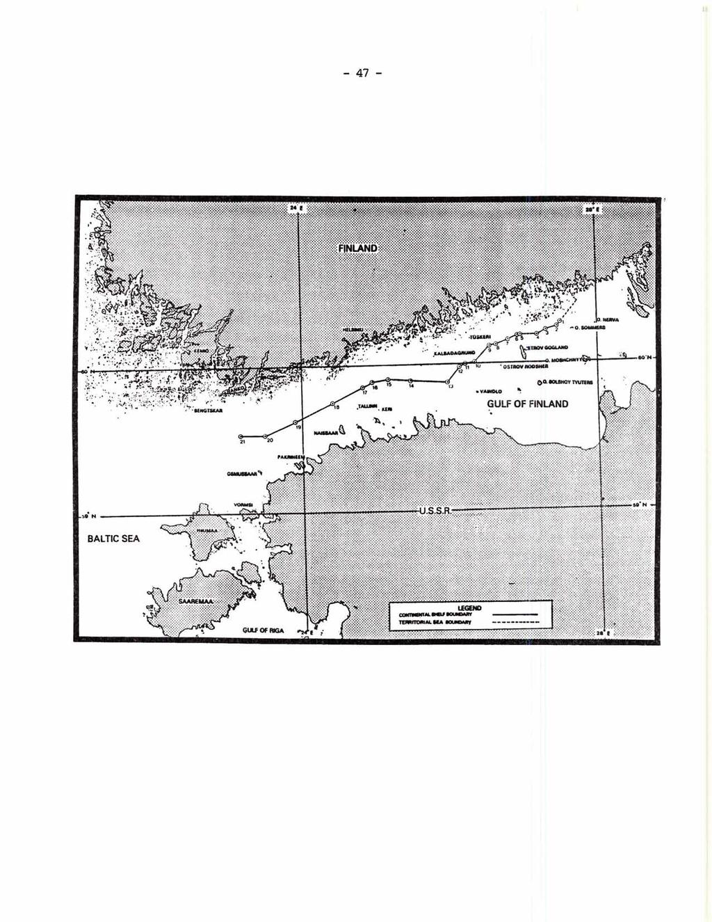
55 Agreement between the Government of the Republic of Finland and the Government of the Union of Soviet Socialist Republics concerning the boundaries of sea areas and of the continental shelf in the Gulf of Finland. Signed at Helsinki on 20 May 1965 L/ l l The Government of the Republic of Finland and the Government of the Union of Soviet Socialist Republics, Having regard to the favourable development of relations between Finland and the Soviet Union, founded on the 1948 Finnish-Soviet Treaty of Friendship, Co-operation and Mutual Assistance, and to the interests of Finnish fishermen, Desiring to define the boundaries of sea areas and of the continental shelf in the Gulf of Finland and thus contribute to the further development of good-neighbourly relations between the two countries, I I Having regard to the Geneva Conventions of 1958 on the territorial sea and the contiguous zone and on the continental shelf, Have decided to conclude this Agreement and have for that purpose appointed as their plenipotentiaries the undersigned, who, having exchanged their full powers, found in good and due form, have agreed as follows: Article 1 The Contracting Parties agree that the sea frontier between ~inlgnd and the USSR and the boundaries of Finnish and Soviet territorial waters in the section of the Gulf of Finland to the north-east of the island of Suursaari (Gogland) shall be drawn as follows: The sea frontier between the Republic of Finland and the Union of Soviet Socialist Republics shall follow a straight line in a south-westerly direction from the terminal point of the sea frontier fixed in 1940 and confirmed by the 1947 Treaty of Peace with Finland, whose co-ordinates are 60 15'35" north latitude and 27O30'43" east longitude, to the point whose co-ordinates are 60 13'42" north latitude and 27O27'50" east longitude and shall then turn and follow a straight line in a west-south-westerly direction to the point whose co-ordinates are 60 12'19" north latitude and 27 18'01" east longitude, which shall be the terminal point of the sea frontier between Finland and the Soviet Union. From the aforementioned terminal point of the sea frontier, the boundary of Soviet territorial waters shall follow a straight line in a south-westerly direction to the point, situated on the boundary of Soviet territorial waters fixed in 1940 and confirmed by the 1947 Treaty of Peace with Finland, whose co-ordinates are 60 08'49" north latitude and 27O04'36" east longitude. i l1 l/ United Nations, Treaty Series, vol. 566, p. 31. Entered i'ntb force on 25 May Map: Gulf of Maine case, annexes to the reply submitted by Canada, vol. I, State Practice in Maritime Delimitation by Agreement, p I! l1 l II
56 The boundary of Finnish territorial waters shall follow a straight line in a westerly direction from the aforementioned terminal point of the sea frontier to the point, situated on the boundary of Finnish territorial waters fixed in 1940 and confirmed by the 1947 Treaty of Peace with Finland, whose co-ordinates are 60 12'19" north latitude and 27O13'49" east longitude. Article 2 The Contracting Parties agree not to extend their fishing and other areas in the section of the Gulf of Finland to the north of the island of Suursaari (Gogland) beyond a line marking the middle of the water area between the boundaries of Finnish and Soviet territorial waters fixed in 1940 and confirmed by the 1947 Treaty of Peace with Finland. The said line shall begin at the point whose co-ordinates are ' north latitude and 27O11.3' east longitude and run in a generally westerly direction through the point whose co-ordinates are ' north latitude and 26O57.9' east longitude and the point whose co-ordinates are ' north latitude and 26O54.9' east longitude to the point whose co-ordinates are ' north latitude and 26O47.9' east longitude, which shall be the initial point of the median line in the section of the Gulf of Finland to the west of the island of Suursaari (Gogland). Article 3 The Contracting Parties agree not to extend their territorial waters or their fishing and other areas in the section of the Gulf of Finland to the west of the island of Suursaari (Gogland) beyond the median line passing through the points whose geographical co-ordinates are the following: ' north latitude and 26O47.9' east longitude, ' north latitude and 26O38.4' east longitude, ' north latitude and 26'32.6' east longitude, ' north latitude and 26O20.8' east longitude, 59O59.4' north latitude and 26O13.1' east longitude, 59O58.4' north latitude and 26O08.4' east longitude, 59O52.0' north latitude and 25O58.5' east longitude, 59O52.9' north latitude and 25O28.0' east longitude, 59O53.6' north latitude and 25O10.6' east longitude, 59O52.4' north latitude and 24O57.6' east longitude, 59O50.8' north latitude and 24O49.7' east longitude, 59O44.5' north latitude and 24O24.8' east longitude, 59O37.4' north latitude and 23O54.8' east longitude, 59O31.9' north latitude and 23O30.1' east longitude, 59O32.0' north latitude and 23O10.0' east longitude.
57 Article 4 The lines of the sea frontier and of the boundaries of Finnish and Soviet territorial waters referred to in article 1 as well as the lines referred to in articles 2 and 3 and the geographical co-ordinates through which the said lines pass are indicated on charts Nos. 400, 403 and 404 (date of issue: 1964), which are annexed to this agreement. All the co-ordinates referred to in this Agreement conform to the system of co-ordinates employed in the charts. Article 5 The Contracting Parties shall mark at the appropriate sites the point where the sea frontier between the Republic of Finland and the Union of Soviet Socialist Republics turns and its terminal point, the geographical co-ordinates of which are, respectively, 60 13'42" north latitude, 27O27'50" east longitude and 60 12'19" north latitude, 27O18'0lU east longitude. The costs incurred in connexion with these operations shall be shared equally by the Contracting Parties. l II Article 6 The lines referred to in articles 2 and 3 of this Agreement shall constitute the boundary of the continental shelf of the Republic of Finland and of the Union of Soviet Socialist Republics in the Gulf of Finland. Article 7 This Agreement shall be ratified and shall enter into force on the date of the exchange of the instruments of ratification. The exchange of the instruments of ratification shall take place in Moscow as soon as possible. I II DONE at Helsinki on 20 May 1965, in duplicate in the Finnish and Russian languages, both texts being equally authentic. l
58 Aqreement between the Government of the Republic of Finland and the Government of the Union of Soviet Socialist Republics concerning the boundary of the continental shelf between Finland and the Soviet Union in the north-eastern part of the Baltic Sea. Signed at Helsinki on 5 May 1967 L/ The Government of the Republic of Finland and the Government of the Union of Soviet Socialist Republics, Having regard to the successful development of relations between Finland and the Soviet Union founded on the 1948 Finnish-Soviet Treaty of Friendship, Co-operation and Mutual Assistance, Desiring to define the boundary of the continental shelf between Finland and the Soviet Union in the north-eastern part of the Baltic Sea, Having regard to the agreement reached in this matter between Finland and the Soviet Union by an exchange of letters on 20 May 1965, Taking into account the Agreement of 20 May 1965 between Finland and the Soviet Union concerning the boundaries of sea areas and of the continental shelf in the Gulf of Finland, Bearing in mind the Geneva Convention of 1958 on the continental shelf, Have decided to conclude this Agreement and have for that purpose appointed as their plenipotentiaries the undersigned, who, having exchanged their full powers, found in good and due form, have agreed as follows: Article 1 The Contracting Parties agree that the boundary of the continental shelf between the Republic of Finland and the Union of Soviet Socialist Republics in the north-eastern part of the Baltic Sea in the section extending to the west of the line joining the Hankoniemi peninsula, the island of Osmussaari and Cape ~oosaspaa and up to the line joining the Finnish navigational mark on the island of ~rimsorarna and the Soviet lighthouse at Ristna on the island of Hiiumaa shall be the median line. II ' I I The said median line begins at the point whose co-ordinates are 59O32.0' north latitude and 23O10.0' east longitude, established by article 3 of the above-mentioned Finnish-Soviet Agreement of 20 May 1965, and runs in a westerly direction through the points whose geographical co-ordinates are the following: 59O25.2' north latitude and 22O45.5' east longitude; 59O23.1' north latitude and 22O10.3' east longitude. l/ United Nations, Treaty Series, vol. 640, p Entered into force on 15 March Map: Gulf of Maine case, annexes to the reply submitted by Canada, vol. I, State Practice in Maritime Delimitation by Agreement, p. 142.
59
60 The median line ends at the point whose co-ordinate are 59O19.0' north latitude and ' east longitude and which is situated on the line joining the Finnish navigational mark on the island of ~rimsorarna and the Soviet lighthouse at Ristna on the island of Hiiumaa. Article 2 The boundary of the continental shelf between the Republic of Finland and the Union of Soviet Socialist Republics referred to in article 1 is indicated on Soviet chart No. 444, scale 1:200,000 (date of issue: 17 July 1965), which is annexed to this Agreement. All the co-ordinates referred to in this Agreement conform to the system of co-ordinates employed in the chart. Article 3 This ~~reement shall be ratified and shall enter into force on the date of the exchange of the instruments of ratification. The exchange of the instruments of ratification shall take place in Moscow as soon as possible. DONE at Helsinki on 5 May 1967, in duplicate in the Finnish and Russian languages, both texts being equally authentic.

61
62 Agreement between Sweden and Norway concerning the delimitation of the continental shelf. Done at Stockholm on 24 July 1968 &/ The Government of the Kingdom of Sweden and the Government of the Kingdom of Norway, Having decided to establish the boundary between the areas of the continental shelf over which Sweden and Norway respectively exercise sovereign rights for the purposes of the exploration and utilization of natural resources, Have agreed as follows: Article 1 The boundary between the areas of the continental shelf over which Sweden and Norway respectively exercise sovereign rights for the purposes of the exploration and utilization of natural resources shall in principle be a median line, drawn in such a way that every point on it is equidistant from the nearest points on the baselines from which the breadth of the territorial sea of Sweden and Norway respectively is measured. I I Article 2 In accordance with the principle established in article 1 but with certain divergencies in order to arrive at a practical and expedient delineation, the boundary shall be drawn between the following five points: 1. The westernmost point of the outer boundary of Sweden's territorial sea in the direction of Norway. The point has the following co-ordinates: I ' I l I 58O 54' 50.2" N, 10 45' 28.1" E. 2. The point where the boundary line established by the international arbitral award of 23 October 1909 fixing part of the sea frontier between Sweden and Norway intersects the outer boundary of the Norwegian territorial sea as drawn at a distance of one geographical mile (7,420 metres) from the Norwegian baseline established by the Royal Decree of 18 July 1952 concerning the fishery limit south of Traena (Norsk Lovtidend, 1952, part 2, pp. 824 et seq). The point has the following co-ordinates: I I 3. The point of intersection between a line drawn at a distance of 12 nautical miles from the aforementioned Norwegian baseline and a line drawn at a distance of 12 nautical miles from the Swedish baseline established by the ST/LEG/SER.B/16, p Entered into force on 18 March Map: Gulf of Maine case, annexes to the reply submitted by Canada, vol. I, State Practice in Maritime Delimitation by Agreement, p. 156.
63 Royal Notice of 3 June 1966 specifying the particulars for the calculation of the Swedish territorial sea (Svensk forfattningssamling No. 375). The point has the following co-ordinates: l l The point has the following co-ordinates: The point has the following co-ordinates: The positions of the above-mentioned five points are defined in relation to the European Datum (First Adjustment, 1950). l 1 1 The boundary line shall be drawn between points 1, 2 and 3 in the form of straight lines (compass lines) and between points 3, 4 and 5 in the form of arcs of great circles. Article 3 The positions of points 1 to 5 as defined in article 2 are indicated on the annexed chart (Norwegian marine chart No. 305), on which the boundary line specified in the same article is also shown. I l Article 4 If natural resources on the sea-bed or in the subsoil thereof extend on both sides of the boundary line defined in article 2 and the natural resources situated in the area of the continental shelf belonging to one State can be exploited wholly or in part from the area belonging to the other State, both States shall at the request of either State endeavour to reach agreement on the most effective means of utilizing such natural resources and on the manner in which the proceeds are to be apportioned. Article 5 The agreement is to be ratified, and the instruments of ratification exchanged at Oslo. The agreement shall enter into force on the date of the exchange of the instruments of ratification. l II l l l

64
65 I l Treaty between the Polish People's Republic and the German Democratic Republic concerning the delimitation of the continental shelf in the Baltic Sea. Signed at Berlin on 29 October 1968 g/ The Council of State of the Polish People's Republic and the Council of State of the German Democratic Republic, l II' Desiring to promote the exploration and exploitation of the natural resources of the continental shelf in the Baltic Sea in accordance with the provisions of the Geneva Convention on the Continental Shelf of 29 April 1958, Have decided to conclude this Treaty and have for that purpose appointed as their plenipotentiaries: The Council of State of the Polish People's Republic: Adam Kruczkowski, Under-Secretary of State in the Ministry of Foreign Affairs of the Polish People's Republic; The Council of State of the German Democratic Republic: I 1 1 Oskar Fischer, Deputy Minister for Foreign Affairs of the German Democratic Republic, who, having exchanged their full powers, found in good and due form, have agreed as follows: Article 1 The lateral boundary between the continental shelf of the Polish People's Republic and that of the German Democratic Republic shall be in principle, in accordance with article 6 of the Geneva Convention on the Continental Shelf, a line every point of which is equidistant from the nearest points of the baselines from which the breadth of the territorial waters of each Contracting Party is measured. Article 2 1. In accordance with the principle set forth in article 1, the lateral boundary shall consist of the following straight lines: a line extending from the terminal point of the land frontier between the two Contracting Parties on the island of Uznam (Usedom) to point A, a line passing through points A, B, C, D, E, F, G and H, and an extension of the line between points G and H to a point equidistant from the nearest points of the baselines of the Polish People's Republic, the German Democratic Republic and the Kingdom of Denmark. l II l / I l/ United Nations, Treaty Series, vol. 768, p Entered into force on 16 April 1969 (map attached to the Agreement).
66 2. The points referred to in paragraph 1 have the following geographical co-ordinates: " north latitude, 54 05'20" north latitude, " north latitude, 54Ol3 ' 44" north latitude, 54O13'05" north latitude, 54 20'28t' north latitude, 54O23'56" north latitude, '1 north latitude, east longitude, east longitude, east longitude, east longitude, east longitude, east longitude, east longitude, east longitude. 3. The geographical co-ordinates specified in paragraph 2 are given in north geographic latitude and east geographic longitude in relation to the prime meridian at Greenwich, in accordance with chart No. 151, October 1965 edition, issued by the Bureau of Marine Hydrography of the German Democratic Republic. I 4. The course of the boundary line is indicated on the annexed chart, which is an integral part of this Treaty. Article 3 The provisions of this Treaty shall in no way affect the legal status of the waters of the high seas superjacent to the continental shelf or that of the airspace above those waters. I ' Article 4 This Treaty shall be registered with the Secretariat of the United Nations in accordance with Article 102 of the Charter of the United Nations. Article 5 This Treaty is subject to ratification and shall enter into force on the date of the exchange of the instruments of ratification, which shall take place at Warsaw. DONE at Berlin on 29 October 1968, in duplicate in the Polish and German languages, both texts being equally authentic.
67 PoLlsn PEOPLE'S REPUBLIC DEMOCRATIQUE ALLEMANDE REPUBLIQUE POPULAIRE DE POLOGNE
68 Treaty between the Polish People's Republic and the Union of Soviet Socialist Republics concerning the boundary of the continental shelf in the Gulf of Gdansk and the south-eastern part of the Baltic Sea. Signed at Warsaw on 28 August 1969 L/ li l The Council of State of the Polish People's Republic and the Presidium of the Supreme Soviet of the Union of Soviet Socialist Republics, Desiring to intensify and expand the friendly, good-neighbourly relations existing between the Polish People's Republic and the Union of Soviet Socialist Republics, Desiring to define the boundary of the continental shelf between the Polish People's Republic and the Union of Soviet Socialist Republics in the Gulf of Gdansk and the south-eastern part of the Baltic Sea, Having regard to the provisions of the Geneva Convention on the Continental Shelf of 29 April 1958, Reaffirming the principles set out in the Declaration on the Continental Shelf in the Baltic Sea signed in Moscow on 23 October 1968 by the Governments of the Polish People's Republic, the Union of Soviet Socialist Republics and the German Democratic Republic, Have decided to conclude this Treaty and have for that purpose appointed as their plenipotentiaries: The Council of State of the Polish People's Republic: Zygfryd Wolniak, Under-Secretary of State in the Ministry of Foreign Affairs of the Polish People's Republic; The Presidium of the Supreme Soviet of the Union of Soviet Socialist Republics: Leonid Fedorovich Ilyichev, Deputy Minister for Foreign Affairs of the USSR, who, having exchanged their full powers, found in good and due form, have agreed as follows: Article 1 The boundary of the continental shelf between the Polish People's Republic and the Union of Soviet Socialist Republics in the Gulf of Gdansk and the south-eastern part of the Baltic Sea shall, with slight variations, be a line equidistant from the nearest points of the baselines, from which the breadth of the territorial waters of each Contracting Party is measured. The said line shall begin at the point at which the outer limit of Polish territorial waters intersects the line delimiting the territorial waters of the Polish People's Republic and the USSR established in the Protocol of 18 March 1958 between the Government of the Polish People's Republic and the l/ United Nations, Treaty Series, vol. 769, p. 75. Entered into force - on 13 May 1970 (map attached to the Agreement).
69 Government of the Union of Soviet Socialist Republics concerning the delimitation of Polish and Soviet territorial waters in the Gulf of Gdansk of the Baltic Sea; it shall follow the line of the boundary of the territorial waters of the USSR to its terminal point and shall then continue in the same direction to point A, whose geographical co-ordinates are 54O40.2' north latitude and 19O18.9' east longitude, thence through the points whose geographical co-ordinates are the following: B - 54'48.9' north latitude, 19O20.7' east longitude, C - 55'20.8' north latitude, 19'03.8' east longitude, D - 55O51.0' north latitude, 18O56.2' east longitude. and then up to the point of intersection of the boundaries of the continental shelf appertaining to the Polish People's Republic, the Union of Soviet Socialist Republics and the Kingdom of Sweden. 1 II Article 2 The boundary of the continental shelf between the Polish People's Republic and the Union of Soviet Socialist Republics defined in article 1 is indicated on chart No. 1150, issued in 1966 by the Hydrographical Department of the Ministry of Defence of the USSR, which is annexed to this Treaty and constitutes an integral part thereof. All the geographical co-ordinates referred to in this Treaty conform to the system employed in the chart. Article 3 The provisions of this Treaty shall in no way affect the legal status of the waters of the high seas superjacent to the continental shelf or that of the airspace above those waters. Article 4 This Treaty shall be registered with the Secretariat of the United Nations in accordance with Article 102 of the Charter of the United Nations. Article 5 This Treaty is subject to ratification and shall enter into force on the date of the exchange of the instruments of ratification, which shall take place at Moscow as soon as possible. DONE at Warsaw on 28 August 1969, in duplicate in the Polish and Russian languages, both texts being equally authentic. I l II II
70 ANNEXE L'ACCORO entra Ia R6publique populrh de Polognr et I'Union dn Rlpubliqur socirlistw rwiitiqua concernant Ie tnd de Ia him du plahau contin ~ t dons k ph@ dr Gdansk at - danr In pertie ddst de Ia mer Baltique. Limit, du pbtnu continrntal mtrr Ie Riplbliqw populrira dr Polom 8l I'Union da R& publiqun soci8listrr mviltiqur IAP NO. 2W4 (bl X
71 (b) SOUTH ATLANTIC Territorial sea and continental shelf boundary between Senegal and Guinea-Bissau, 26 April 1960 (exchange of letters between Portugal and France), 26 April 1960" L/ MINISTRY OF FOREIGN AFFAIRS Decree No of May 25, 1960, publishing the Exchange of Notes between France and Portugal regarding the maritime boundary between Senegal and Portuguese Guinea, signed 26 April On the report of the Prime Minister and the Minister of Foreign Affairs; Considering articles of the Constitution; Considering Decree No of 14 March 1953, concerning the ratification and publication of international commitments undertaken by France, The President of the Republic hereby decrees: Article 1 The exchange of notes between France and Portugal regarding the maritime boundary between Senegal and Portuguese Guinea, signed 26 April 1960, shall be * This Agreement is the object of a dispute between the two States. l/ See United States Department of State, Office of the Geographer, ~nternational Boundary Study, Series A, Limits in the Seas, No. 68, 15 March Map: Gulf of Maine case, annexes to the reply submitted by Canada, vol. I, State Practice in Maritime Delimitation by Agreement, p. 90.
72 EMBASSY OF FRANCE IN PORTUGAL Lisbon, 26 April 1960 His Excellency Antonio de Oliveira Salazar President of the Council Acting Minister for Foreign Affairs Lisbon Mr. President: II ' Pursuant to the talks held in Lisbon 8-10 September 1959, with a view to defining the maritime boundary between the Republic of Senegal and the Portuguese Province of Guinea, taking into account the Geneva Conventions of 29 April 1958, drafted by the United Nations Conference on the Law of the Sea, I have the honor, on behalf of the French Republic and the Community, to propose to Your Excellency the following: To the external limit of the territorial seas, the boundary would be defined by a straight line, running at 240, starting from the intersection of the extension of the land boundary and the low-water mark, represented for that purpose by the Cape Roxo light. With regard to the contiguous zones and the continental shelf, the delimitation would consist of the straight line extension in the same direction of the territorial sea boundary. In the spirit of friendship and neighbourly relations that has always existed between our countries, the competent authorities would favor, as appropriate, mutual co-operation between natural or juristic persons authorized to exercise rights on one side or the other of the line defined above. I should be grateful if Your Excellency would inform me whether these proposals meet with the approval of the Portuguese Government. Accept, Mr. President, the assurances of my very high consideration. Signed: B. de Menthon
73 MINISTRY OF FOREIGN AFFAIRS Mr. Ambassador: I have the honor to acknowledge receipt of Your Excellency's note of April 26, 1960, which reads as follows: l l [Same text as above note] I I I have the honor to inform Your Excellency that the terms of your note transcribed above meet with the approval of the Portuguese Government, with the understanding that the aforesaid note and this reply shall constitute the instruments of the agreement reached on the subject between the two Governments. I take this opportunity to present to you, Mr. Ambassador, the assurance of my highest consideration. I I A. 0. Salazar Minister of Foreign Affairs
74
75 l/ League of Nations, Treaty Series, vol. CCV, p Entered into force on 22 September I II' Map: Gulf of Maine case, annexes to the reply submitted by Canada, vol. I, State Practice in Maritime Delimitation by Agreement, p. 64. ' l ' l CARIBBEAN REGION Treaty between His Majesty in respect of the United Kingdom and th6' President of the United States of Venezuela relating to the submarine areas of the Gulf of Paria. Signed at Caracas, 26 February 1942 L/ His Majesty The King of Great Britain, Ireland and the British Dominions beyond the Seas, Emperor of India, and the President of the United States of Venezuela, Desiring in a spirit of goodwill to make provision for and to define as between themselves their respective interests in the submarine areas of the Gulf of Paria, Have decided to conclude a Treaty for that purpose and, to that end, have named as their Plenipotentiaries: His Majesty The King of Great Britain, Ireland and the British Dominions beyond the Seas, Emperor of India (hereinafter referred to as His Majesty The King), for The United Kingdom of Great Britain and Northern Ireland: Mr. Donald St. Clair Gainer, C.M.G., O.B.E., his Envoy Extraordinary and - Minister Plenipotentiary at Caracas; The President of the United States of Venezuela: Dr. Caracciolo ~arra-~irez, Minister of Foreign Relations: Who, having communicated to each other their full powers, found and due form, have agreed as follows: in good Article In this Treaty the term "submarine areas of the Gulf of Paria" denotes the - - sea-bed and sub-soil outside of the territorial waters of the Hiqh Contractinu Parties to one or the other side of the lines A-B, B-Y and Y-X. Article 2 L' (1) His Majesty The King declares that he for his part will no l assert any clai m to sovereignty or control over those parts of the submarine areas of the Gulf of Paria which lie westerly of the line A-B, or southerly of the lines B-Y and Y-X respectively described in article 3 of the present Treaty, and that he will recognize any rights of sovereignty or control which have been or may hereafter be lawfully acquired by the United States of Venezuela over the said parts of the submarine areas of the Gulf of Paria.
76 (2) The President of the United States of Venezuela declares that he for his part will not assert any claim to sovereignty or control over those parts of the submarine areas of the Gulf of Paria which lie easterly of the line A-B or northerly of the lines B-Y and Y-X respectively, described in article 3 of the present Treaty, and that he will recognize any rights of sovereignty or control which have been or may hereafter be lawfully acquired by His Majesty The King over the said parts of the submarine areas of the Gulf of Paria. l Article 3 The lines A-B, B-Y and Y-X mentioned in the preceding article are drawn on the annexed map and are defined as follows: Line A-B runs from Point A, which is the intersection of the central meridian of the Island of Patos with the southern limit of the territorial waters of the said Island, the approximate co-ordinates of which are: Latitude 10 35' 04" N., Longitude 61 51' 53" W. From there the line runs straight to Point B which is situated at the limit of the territorial waters of Venezuela at the point of their intersection with the meridian of 62O 05' 08" W., the approximate latitude of which is 10 02' 24" N. 1 1 Line B-Y runs from Point B, already established, and follows the limits of the territorial waters of Venezuela to Point Y, where the said limits intersect the parallel of 9O 57' 30" N., the approximate longitude of which is 61' 56' 40" W. Line Y-X runs from Point Y, already established, and follows the said parallel of 9O 57' 30" N. to Point X, situated on the meridian of 61' 30' 00" W. I l The longitude of the central meridian of the Island of Patos to which this article refers shall be determined by taking the mathematical half of the most eastern and the most western longitudes of the said Island. Should the straight lines A-B or Y-X described in this article intersect in their course the outside limit of the territorial waters of either of the two High Contracting Parties, the dividing line shall follow along the said limit until it reaches again the intersecting straight line in conformity with the stipulations in articles 1 and 5 of this Treaty, which exclude the bed of the sea and the sub-soil of territorial waters. The co-ordinates of points A, B and Y which are here given approximately shall be determined with exactness by the Commission provided for in article 4 of this Treaty. Article 4 (1) The High Contracting Parties shall, as soon as practicable after the coming into force of this Treaty, appoint a mixed Commission to take all necessary steps to demarcate the lines A-B, B-Y and Y-X by means of buoys or other visible methods on the surface of the sea or on the land as the case may be. Any buoys or other means employed shall, however, conform in all respects to the provisions of article 6 of this Treaty. (2) The manner in which this mixed Commission shall be constituted and the instructions to which it shall be subject for the fulfilment of its duties shall be laid down in a special protocol or by an exchange of notes.
77 Article 5 This Treaty refers solely to the submarine areas of the Gulf of Paria, and nothing herein shall be held to affect in any way the status of the islands, islets or rocks above the surface of the sea together with the territorial waters thereof. Article 6 Nothing in this Treaty shall be held to affect in any way the status of the waters of the Gulf of Paria or any rights of passage or navigation on the surface of the seas outside the territorial waters of the Contracting Parties. In particular, passage or navigation shall not be closed or be impeded by any works or installations which may be erected, which shall be of such a nature and shall be so constructed, placed, marked, buoyed and lighted, as not to constitute a danger or obstruction to shipping. Article 7 Each of the High Contracting Parties shall take all practical measures to prevent the exploitation of any submarine areas claimed or occupied by him in the Gulf from causing the pollution of the territorial waters of the other by oil, mud or any other fluid or substance liable to contaminate the navigable waters or the foreshore and shall concert with the other to make the said measures as effective as possible. Article 8 Each of the High Contracting Parties shall cause to be inserted in any concession which may be granted for the exploitation of submarine areas in the Gulf of Paria stipulations for securing the effective observance of the two preceding articles, including a requirement for the use by the concessionaire of modern equipment, and shall cause the operation of any such concession to be supervised in order to ensure that the provisions of the present Treaty are complied with. Article 9 All differences between the High Contracting Parties relating to the interpretation or execution of this Treaty shall be settled by such peaceful means as are recognized in international law. Article 10 The present Treaty shall be ratified in conformity with the respective laws of the High Contracting Parties and shall come into force upon the exchange of ratifications which shall take place in London. IN WITNESS WHEREOF the above-named Plenipotentiaries have signed the present Treaty and have affixed thereto their seals. DONE in duplicate in the English and Spanish languages at Caracas, the 26th day of February, 1942.
78
79 INDIAN OCEAN REGION Persian Gulf Bahrain-Saudi Arabia boundary aqreement 22 February 1958 L/ I ' Whereas the regional waters between the Kingdom of Saudi Arabia and the Government of Bahrain meet together in many places overlooked by their respective coasts, And in view of the royal proclamation issued by the Kingdom of Saudi Arabia on the 1st Sha'aban in the year 1368 (corresponding to 28 May 1949) and the ordinance issued by the Government of Bahrain on 5 June 1949 about the exploitation of the sea-bed, And in view of the necessity for an agreement to define the underwater areas belonging to both countries, And in view of the spirit of affection and mutual friendship and the desire of H.M. the King of Saudi Arabia to extend every possible assistance to the Government of Bahrain, I l The following agreement has been made: First clause 1. The boundary line between the Kingdom of Saudi Arabia and the Bahrain Government will begin, on the basis of the middle line from point 1, which is situated at the mid-point of the line running between the tip of the Ras a1 Bar (A) at the southern extremity of Bahrain and Ras Muharra (B) on the coast of the Kingdom of Saudi Arabia. 2. Then the above-mentioned middle line will extend from point 1 to point 2 situated at the mid-point of the line running between point A and the northern tip of the island of Zakhnuniya (C). 3. Then the line will extend from point 2 to point 3 situated at the mid-point of the line running between point A and the tip of Ras Saiya (D). 4. Then the line will extend from point 3 to point 4, which is defined on the attached map and which is situated at the mid-point of the line running between the two points E and F which are both defined on the map. 5. Then the line will extend from point 4 to point 5, which is defined on the map and which is situated at the point [&l of the line running between the two points G and H which are defined on the map. - l/ ST/LEG/SER.B/16, p Entered into force on 22 February Map: Gulf of Maine case, annexes to the reply submitted by ~anada, vol. 1. State Practice in Maritime Delimitation by Agreement, p. 84. ' II l l
80 6. Then the line will extend from point 5 to point 6, which is defined on the map and which is situated at the mid-point of the line running between the two points I and J which are defined on the map. 7. Then the line will extend from point 6 to point 7 situated at the mid-point of the line running between the south-western tip of the island of Umm Nasan (K) and Ras A1 Kureya (L). 8. Then the line will extend from point 7 to point 8 situated at the western extremity of the island A1 Baina As Saghir, leaving the island to the Government of Bahrain. 9. Then the line will extend from point 8 to point 9 situated at the eastern extremity of the island A1 Baina A1 Kabir, leaving the island to the Kingdom of Saudi Arabia. 10. Then the line will extend from point 9 to point 10 situated at the mid-point of the line running between the north-western tip of Khor Fasht (M) and the southern end of the island of Chaschus (N). 11. Then the line will extend from point 10 to point 11 situated at the mid-point of the line running between point 0 situated at the western edge of Fasht A1 Jarim and point N referred to in subsection 10 above. 12. Then the line will extend from point 11 to point 12 situated at latitude 26 degrees 31 minutes 48 seconds north and longitude 50 degrees 23 minutes 15 seconds east approximately. 13. Then the line will extend from point 12 to point 13 sitwted at latitude 26 degrees 37 minutes 15 seconds north and longitude 50 degrees 33 minutes 24 se~onds east approximately. I 14. ~hek the line will extend from point 13 to point 14 situated at latitude 26 degrees 59 minutes 30 seconds north and longitude 50 degrees 46 minutes 24 seconds east approximately, leaving the Rennie Shoals (known as Najwat A1 Riqai and Fasht A1 Anawiyah) to the Kingdom of Saudi Arabia. 15. Then the line will extend from point 14 in a north-easterly direction to the extent agreed upon in the royal proclamation issued on the 1st Sha'aban in the year 1368 (corresponding to 28 May 1949) and in the ordinance issued by the Government of Bahrain on 5 June Everything that is situated to the left of the above-mentioned line in the above subsections belongs to the Kingdom of Saudi Arabia and everything to the right of that line to the Government of Bahrain, with the obligation of the two Governments to accept what will subsequently appear in the second clause below. Second clause The area situated within the six defined sides is as follows: 1. A line beginning from a point situated at latitude 27 degrees north and longitude 50 degrees 23 minutes east approximately.
81 2. From there to a point situated at latitude 26 degrees 31 minutes 48 seconds north and longitude 50 degrees 23 minutes 15 seconds east approximately. 3, From there to a point situated at latitude 26 degrees 37 minutes north and longitude 50 degrees 33 minutes east approximately. I I 4. From there to a point situated at latitude 26 degrees 59 minutes 30 seconds north and longitude 50 degrees 46 minutes 24 seconds east approximately. 5. From there to a point situated at latitude 26 degrees 59 minutes 30 seconds north and longitude 50 degrees 40 minutes east. 6. From there to a point situated at latitude 27 degrees north and longitude 50 degrees 40 minutes east approximately. I I From there to the starting point. This area cited and defined above shall be in the part falling to the Kingdom of Saudi Arabia in accordance with the wish of H.H. the Ruler of Bahrain and the agreement of H.M. the King of Saudi Arabia. The exploitation of the oil resources in this area will be carried out in the way chosen by His Majesty on the condition that he grants to the Government of Bahrain one half of the net revenue accruing to the Government of Saudi Arabia and arising from this exploitation, and on the understanding that this does not infringe the right of sovereignty of the Government of Saudi Arabia nor the right of administration over this above-mentioned area. I l Third clause Two copies of a map shall be attached to this agreement, making as clear as possible the positions and points referred to in the foregoing subsections, subject to the map being made final by the expert knowledge of the committee defined in the fourth clause below. This map shall become final and an integral part of this agreement after approval and signature by the accredited representatives of the two Governments on behalf of the two parties. l l Fourth clause The two parties shall choose a technical body to undertake the necessary measures to confirm the boundaries in accordance with the provisions of this agreement on the condition that this body shall complete its work two months at the most after the date of execution of this agreement. Fifth clause I I After the committee referred to in the fourth clause has completed its work and the two parties agree on the final map which it will have prepared a body of technical delegates from both sides shall undertake the placing of signs and the establishing of the boundaries in accordance with the detailed announcements made clear in the final map. ' 1 1 Sixth clause Ill I' This agreement shall come into effect from the date on which it is signed by the two parties. ' l
82
83 Offshore boundary agreement between Abu Dhabi and Dubai, 18 February 1968 L/ In the name of God, the Merciful, the Compassionate, This Agreement on the redefinition of the offshore boundary between the Amirates of Abu Dhabi and Dubai is concluded between His Highness Shaikh Zayid ibn Sultan A1 Nahyan, the Ruler of the Amirate of Abu Dhabi, and His Highness Shaikh Rashid ibn Sa'id al-maktum, the Ruler of the Amirate of Dubai. Considering that the present offshore boundary between the Amirates of Dubai and Abu Dhabi starts at Ras Hasian on the coast and extends seawards in a straight line in a northwesterly direction passing to the west of the Fateh wells belonging to the Amirate of Dubai; And considering that the two contracting parties wish to redefine this boundary to the benefit of their countries and the well-being of their peoples; Agreement and assent has been reached between the two contracting parties in respect of the following: (1) This boundary shall be redefined in such a way as to annex to the Amirate of Dubai a part of the sea area lying to the west of the aforesaid present boundary and forming a parallelogram whose horizontal base is ten kilometres measured along the coast in a westerly direction from Ras Hasian and whose vertical side is equal in length to the present boundary referred to above, so that the area thus described shall lie to the west of the Fateh wells and extend in a southwesterly direction to the coast. (2) The aforesaid area shall become part of the possessions and rights of Dubai. This Agreement is hereby signed by the two contracting parties at as-samih on the 18th &y of February 1968, corresponding to the 20th day of Dhu al-qa1dah, 1387 H. l/ New Directions in the Law of the Sea (Dobbs Ferry, N.Y., Oceana ~ublications, 1977), vol. 5, p Entered into force on 18 Febtuary Map: Gulf of Maine case, annexes to the reply submitted by Canada, vol. I, State Practice in Maritime Delimitation by Agreement, p. 152.
84 PERSIAN GULF
85 Agreement concerning the sovereignty over the islands of Al-'Arabiyah and ~arsi and the delimitation of the boundary line separatinq the submarine areas between the Kingdom of Saudi Arabia and Iran (with exchanges of letters, map and annexed Enqlish translation). Signed at Teheran on 24 October 1968 L/ The Royal Government of Saudi Arabia, represented by His Excellency Shaikh Ahrned Zaki Yamani, Minister of Petroleum and Mineral Resources, of the one part and the Imperial Government of Iran, represented by His Excellency Dr. Manoochehr Eghbal, Chairman of the Board and General Managing Director of the National Iranian Oil Company, of the other part. Desirous of resolving the difference between them regarding sovereignty over the islands of Al-'Arabiyah and Farsi and Desirous further of determining in a just and accurate manner the boundary line separating the respective submarine areas over which each party is entitled by international law to exercise sovereign rights, l l Now therefore and with due respect to the principles of the law and particular circumstances, And after exchanging the credentials, have agreed as follows: Article 1 The Parties mutually recognize the sovereignty of Saudi Arabia over the islands of Al-'Arabiyah and of Iran over the island of Farsi. Each island shall possess a belt of territorial sea twelve nautical miles in width, measured from the line of lowest low water on each of the said islands. In the area where these belts overlap, a boundary line separating the territorial seas of the two islands shall be drawn so as to be equidistant throughout its length from the lowest low water lines on each island. l l Article 2 The boundary line separating the submarine areas which appertain to Saudi Arabia from the submarine areas which appertain to Iran shall be a line established as hereinafter provided. Both Parties mutually recognize that each possesses over the seabed and subsoil of the submarine areas on its side of the line sovereign rights for the purpose of exploring and exploiting the natural resources therein. l/ United Nations, Treaty Series, vol. 696, p Entered into force on 29 January I Ill Map: Gulf of Maine case, annexes to the reply submitted by Canada, vol. I, State Practice in Maritime Delimitation by Agreement, p. 160.
86 Article 3 The boundary line referred to in article 2 shall be: (a) Except in the vicinity of Al-'Arabiyah and Farsi, the said line is determined by straight lines between the following points whose latitude and longitude are s~ecified hereinbelow: North latitude East longitude (b) In the vicinity of Al-'Arabiyah and Farsi, a line laid down as follows: At the point where the line described in paragraph (a) intersects the limit of the belt of territorial sea around Farsi, the boundary shall follow the limit of that belt on the side facing Saudi Arabia until it meets the boundary line set forth in article 1 which divides the territorial sea of Farsi and Al-'Arabiyah; thence it shall follow that line easterly until it meets the limit of the belt of territorial sea around Al-'Arabiyah; thence it shall follow the limit of that belt on the side facing Iran until it intersects again the line described in paragraph (a). The map prepared by the A.M. Service Corps of Engineers U.S. Army compiled in 1966 was used and shall be used as the basis for the measurement of the co-ordinates described above and the Boundary Line is illustrated in a copy of the said map signed and attached hereto. Article 4 Each Party agrees that no oil drilling operations shall be conducted by or under its authority within a zone extending five hundred (500) metres in width in the submarine areas on its side of the Boundary Line described in article 3, said zone to be measured from said boundary.
87 Article 5 I This Agreement is done in duplicate in the Arabic and Persian languages, both texts being equally authentic. An English translation thereof is also signed by both Parties and annexed thereto. This Agreement shall enter into force upon the date of exchange of the instruments of ratification which shall take place at Jeddah as soon as possible. IN WITNESS WHEREOF, the above-named plenipotentiaries, duly authorized by their respective Governments, have signed this Agreement. DONE at Teheran, this Second day of Sha'ban, 1388 (Hejira calendar), corresponding to the Second day of Aban, 1347 (Iranian calendar), and to the Twenty Fourth day of October Your Excellency: EXCHANGES OF LETTERS Ia With reference to the offshore boundary agreement signed by us today (hereinafter referred to as "the Agreement") on behalf of our respective Governments, I have the honour to propose the following technical arrangement to facilitate the determination of geographical locations offshore in the Marjan-Fereydoon area: I l~ As soon as possible after the entry into force of the Agreement a joint technical committee of four members shall be established composed of two experts appointed by each Government. This committee shall be charged with establishing agreed positions defined by co-ordinates of latitude and longitude with reference to the map attached to the Agreement, for the following offshore at which tangible markets of various kinds already exist: On the Iranian Side: 1. The well site known as Fereydoun 3 2. The well site known as Fereydoun 2 On the Saudi Arabian Side: 3. The well site known as Fereydoun 7, or in case there shall be no tangible markets therein, the well site known as Marjan 1. It is understood that whenever a new well is drilled on the Saudi Arabian side with tangible markets on it and conveniently close to the boundary line, such a well shall also be included in the reference points, thus making the number of the reference points four altogether. The positions for these points fixed by the committee shall be regarded as accepted by both Governments if neither Government objects within one month after the committee has presented its reports, which report shall be submitted to both Governments on the same date.
88 Thereafter, for all purposes arising under the Agreement positions for oil operations in the Marjan-Fereydoon area carried on under the authority of either Government shall be established by reference to these points in accordance with standard survey techniques. If the foregoing proposal is acceptable to Your Excellency, this letter and your reply to that effect shall constitute an agreement between our respective Governments, effective on the date on which the Agreement comes into force. With assurance of my high esteem. Teheran on 2nd Sha'ban 1388 corresponding to 2nd Aban 1347 and 24 October 1968 For the Royal Government of Saudi Arabia: Abed Zaki Yamani Minister of Petroleum and Mineral Resources His Excellency Dr. Manoochehr Eghbal Chairman of the Board and General Managing Director of the National Iranian Oil Company and Representative of the Imperial Government of Iran I ' IIa I have the honour to inform Your Excellency that I have received Your Excellency's letter of the following text: [See letter 1a1 I have the pleasure to convey to Your Excellency my Government's approval of the contents of your letter, the text of which is hereabove stated, considering that the letter and my reply thereto shall constitute an agreement between our respective Governments, effective on the date on which the Agreement comes into force. With renewed assurance of my high esteem. Teheran on 2nd Sha'ban 1388 corresponding to 2nd Aban 1347 and 24 October For the Imperial Government of Iran: Dr. Manoochehr Eghbal Chairman of the Board and General Managing Director of the National Iranian Oil Company His Excellency Ahmed Zaki Yamani Minister of Petroleum and Mineral Resources Representative of the Royal Government of Saudi Arabia
89 Your Excellency: With reference to the offshore boundary agreement signed by us today on behalf of our respective Governments, I have the honour to propose, for the more effective implementation of this Agreement (hereinafter referred to as "the Agreement") the following understandings: (a) The oil drilling operations which are prohibited by article 4 of the Agreement within the zone therein described (hereinafter referred to as "the Prohibited Area") shall include exploitation carried out directly from the Prohibited Area and shall also extend to all drilling operations which could be carried out within the Prohibited Area from installations which are themselves located outside it. The term "oil drilling operations" as used in article 4 of the Agreement shall mean drilling operations for oil and/or gas. Our two Governments shall ensure that the wells drilled in the immediate vicinity of the Prohibited Area shall be vertical wells: however, when a deviation is technically inevitable at a reasonable cost, such a deviation shall not be deemed as encroachment on the Agreement, provided that the party concerned does not contemplate, by such deviation, the violation of the provisions set forth in the Agreement and this letter. Should our two Governments mutually agree that gas injection and/or drilling an observation well is technically beneficial and advisable for the Marjan-Fereydoon reservoir, our two Governments shall agree on the location, the conducting of drilling the wells and their operations in the Prohibited Area for the sole purpose specified in this paragraph, provided that the wells to be drilled shall be conducted by each Government, directly or through its authorized agent, on its respective side of the Prohibited Area under the terms and condition to be agreed upon by our two Governments. I I l (b) Our two Governments shall, directly or through authorized agents, exchange with each other all obtained directional survey information during the course of drilling operations carried out as from the effective date of the Agreement within two kilometres of the Boundary Line. This exchange shall be made on a reciprocal and continuous basis. (C) Each Government shall ensure that the companies operating under its respective authority shall not carry out operations that may, for technical inconsistency with the conservation rules according to sound oil industry practice, be considered harmful to the oil and gas reservoir in the Marjan-Fereydoon area.
90 This letter and Your Excellency's reply thereto shall constitute an agreement between our respective Governments, to become effective on the date on which the Agreement enters into force. With renewed assurance of my high esteem. Teheran on 2nd Sha'ban 1388 corresponding to 2nd %an and 24 October For the Royal Government of Saudi Arabia: Ahmed Zaki Yamani Minister of Petroleum and Mineral Resources His ~xcellencb Dr. Manoochehr Eghbal Chairman of the Board and General Managing Director of the National Iranian Oil Company and Representative of the Imperial Government of Iran
91 IIb Your Excellency: I have the honour to inform Your Excellency that I have received Your Excellency's letter of the following text: [See letter 11a1 I have the pleasure to convey to Your Excellency my Government's approval of the contents of your letter, the text of which is hereabove stated, considering that the said letter and my reply thereto shall constitute an agreement between our respective Governments, effective on the date on which the Agreement comes into force. l l With renewed assurance of my high esteem. Teheran on 2nd Sha'ban 1388 corresponding to 2nd Aban 1347 and 24 October For the Imperial Government of Iran: Manoochehr Eghbal Chairman of the Board and General Managing Director of the National Iranian Oil Company His Excellency Shaikh Ahmed Zaki Yamani Minister of Petroleum and Mineral Resources and Representative of the Royal Government of Saudi Arabia
92 PERSIAN GULF LEGEND 2744 I
93 Agreement on settlement of maritime boundary lines and sovereign rights over islands between Qatar and Abu Dhabi. Signed on 30 March 1969 L/ Recognizing the cordial and fraternal relations that exist between the two sister Arab States, and desirous of settling maritime boundary lines and sovereign rights over islands on the basis of their mutual interests, the two Contracting Parties have agreed as follows: (1) That "Dina" Island is part of the territory of Abu Dhabi; (2) That the islands of "Lashat" and "Shraho" are part of the territory of Qatar; (3) That both States will have no further national claims against each other in islands and waters beyond the maritime boundary lines herein agreed to: (4) That the maritime boundary lines referred to in paragraph (3) above are as follows: (a) A straight line between Point '#Aw at: Latitude Longitude and point B, "Bir Elbundug", at: Latitude ,79 Longitude ,98 (b) A straight line between point B (described above), and point C, at: Latitude Longitude (C) A straight line from point C (described above) to point D (at Bab Khor Eladid at the territorial sea boundary) at: Latitude Longitude ' (5) That the above points and lines shall as soon as possible be drawn in a small maritime boundary chart in duplicate, each to be signed by both Contracting Parties; (6) That the Contracting Parties will have equal rights of ownership over Vagl Elbundug" and agreed to consult each other in all matters concerning its exploitation; (7) That "Hag1 Elbundug" shall be exploited by ADMA (Abu Dhabi Marine Areas Co.) in accordance with the terms of the agreements between the Company and the Ruler of Abu Dhabi. All revenues, profits and benefits derived I from such exploitation shall be divided in equal shares by the Governmen S of Qatar and Abu Dhabi. l/ ST/LEG/SER.B/16, p Entered into force on 30 March Map: Gulf of Maine case, annexes to the reply submitted by Canada, vol. I, State Practice in Maritime Delimitation by Agreement, p l l
94 "i' PERSIAN GULF
95 Agreement concerning the boundary line dividing the continental shelf between Iran and Qatar, 20 September The Imperial Government of Iran and the Government of Qatar, desirous of establishing in a just, equitable and precise manner the boundary line between the respective areas of continental shelf over which they have sovereign rights in accordance with international law, I Have agreed as follows: Article 1 The Boundary line dividing the continental shelf lying between the territory of Iran, on the one side, and that of Qatar, on the other side, shall consist of geodetic lines between the following points in the sequence given below: Point (1) is the westernmost point on the westernmost part of the northern boundary line of the continental shelf appertaining to Qatar formed by a line of geodetic azimuth 278 degrees 14 minutes 27 seconds west from Point 2 below. Lat. N. Long. E. Point (2 ) Point (3 ) Point (4 Point (5 ) Point ( 6 ) Article 2 If any single geological petroleum structure or petroleum field, or any single geological structure or field of any other mineral deposit, extends across the Boundary line set out in article (1) of this Agreement and the part of such structure or field which is situated on one side of that Boundary line could be exploited wholly or in part by directional drilling from the other side of the Boundary line, then: (a) No well shall be drilled on either side of the Boundary line as set out in article (1) so that any producing section thereof is less than 125 metres from the said Boundary line, except by mutual agreement between the two Governments, (b) Both Governments shall endeavour to reach agreement as to the manner in which the operations on both sides of the Boundary line could be co-ordinated or unitized. l/ See also The law of the sea: maritime boundary agreement&' ( ) (United Nations publication, Sales No. E. 87.V. 12), pp Entered into force on 10 May 1970.
96 I I ' Article 3 I I The Boundary line referred to in article (1) herein has been illustrated on the British Admiralty Chart No which is annexed to this Agreement. The said Chart has been made in duplicate and signed by the representatives of both Governments, each of whom has retained one copy thereof. I Article 4 Nothing in this Agreement shall affect the status of the superjacent waters or airspace above any part of the continental shelf. Article 5 (a) This Agreement shall be ratified and the instruments of ratification shall be exchanged at Doha, Qatar, as soon as possible. (b) This Agreement shall enter into force on the date of the exchange of instruments of ratification. IN WITNESS THEREOF the undersigned, being duly authorised by their respective Governments, have signed the present Agreement. DONE in duplicate at Doha, Qatar, the 20th September 1969, corresponding to the 9th Rajab 1389 and corresponding to the 29th Shahrivar 1348, in the Persian, Arabic and English languages, all texts being equally authoritative.

97
98 IV. PACIFIC REGION (a) EAST PACIFIC Chile, Ecuador and Peru: Declaration on the maritime zone. Signed on 18 August 1952 A/ [Original : Spanish] 1. Governments have the obligation to ensure for their peoples the necessary conditions of subsistence, and to provide them with the resources for their economic development. 2. Consequently, they are responsible for the conservation and protection of their natural resources and for the regulation of the development of these resources in order to secure the best possible advantages for their respective countries. 3. Thus, it is also their duty to prevent any exploitation of these resources, beyond the scope of their jurisdiction, which endangers the existence, integrity and conservation of these resources to the detriment of the peoples who, because of their geographical situation, possess irreplaceable means of subsistence and vital economic resources in their seas. In view of the foregoing considerations, the Governments of Chile, Ecuador and Peru, determined to conserve and safeguard for their respective peoples the natural resources of the marine zones adjacent to their coasts, formulate the following Declaration: I) The geological and biological factors which determine the existence, conservation and development of marine fauna and flora in the waters along the coasts of the countries making the Declaration are such that the former extension of the territorial sea and the contiguous zone are inadequate for the purposes of the conservation, development and exploitation of these resources, to which the coastal countries are entitled. 11) In the light of these circumstances, the Governments of Chile, Ecuador and Peru proclaim as a norm of their international maritime policy that they each possess exclusive sovereignty and jurisdiction over the sea along the coasts of their respective countries to a minimum distance of 200 nautical miles from these coasts. 111) The exclusive jurisdiction and sovereignty over this maritime zone shall also encompass exclusive sovereignty and jurisdiction over the seabed and the subsoil thereof. l/ United Nations, Treaty Series, vol. 1006, p. 323, Entered into force on 18 ~ugust Map: Gulf of Maine case, annexes to the reply submitted by Canada, vol. I. State Practice in Maritime Delimitation by Agreement, pp. 70 and 74.
99 IV) In the case of island territories, the zone of 200 nautical miles shall apply to the entire coast of the island or group of islands. If an island or group of islands belonging to one of the countries making the declaration is situated less than 200 nautical miles from the general maritime zone belonging to another of those countries, the maritime zone of the island or group of islands shall be limited by the parallel at the point at which the land frontier of the States concerned reaches the sea. V) This declaration shall be without prejudice to the necessary limitations to the exercise of sovereignty and jurisdiction established under international law to allow innocent and inoffensive passage through the area indicated for ships of all nations. VI) For the application of the principles contained in this Declaration, the Governments of Chile, Ecuador and Peru hereby announce their intention to sign agreements or conventions which shall establish general norms to regulate and protect hunting and fishing within the maritime zone belonging to them, and to regulate and co-ordinate the exploitation and development of all other kinds of products or natural resources existing in these waters which are of common interest.
100
101 PACIFIC OCEAN
102 (b) WEST PACIFIC Agreement between the Government of Malaysia and the Government of Indonesia on the delimitation of the continental shelves between the two countries. Done at Kuala Lumpur on 27 October 1969 A/ Article 1 (1) The boundaries of the Malaysian and the Indonesian continental shelves in the Straits of Malacca and the South China Sea are the straight lines connecting the points specified in column 1 below whose coordinates are specified opposite those points in columns 2 and 3 below: A. In the Straits of Malacca: (1) Point (2) Longitude E (3) Latitude N B. In the South China Sea (western side - off the east coast of West Malaysia) : (1) Point (2) Longitude E (3) Latitude N l/ ST/LEG/SER.B/16, p Entered into force on 7 November Map: Gulf of Maine case, annexes to the reply submitted by Canada, vol. I, State Practice in Maritime Delimitation by Agreement, pp
103 C. In the South China Sea (eastern side - off the coast of Sarawak): (1) Point (2) Longitude E (3) Latitude N (2) The coordinates of the points specified in paragraph (1) are geographical coordinates and the straight lines connecting them are indicated on the chart attached as Annexure A to this Agreement. (3) The actual location of the above-mentioned points at sea shall be determined by a method to be mutually agreed upon by the competent authorities of the two Governments. (4) For the purposes of paragraph (3) "competent authorities" in relation to Malaysia means the Pengarah, Pemetaan Negara, Malaysia and includes any person authorized by him and in relation to the Republic of Indonesia, the Direktur, Direktorat Hidrografi Angkatan Laut, Republik Indonesia and includes any person authorized by him. Article I1 Each Government hereby undertakes to ensure that all the necessary steps shall be taken at the domestic level to comply with the terms of this Agreement. Article I11 This Agreement shall not in any way affect any future agreement which may be entered into between the two Governments relating to the delimitation of the territorial sea boundaries between the two countries. Article IV If any single geological petroleum or natural gas structure extends across the straight lines referred to in article I and the part of such structure which is situated on one side of the said lines is exploitable, wholly or in part, from the other side of the said lines, the two Governments will seek to reach agreement as to the manner in which the structure shall be most effectively exploited. Article V Any dispute between the two Governments arising out of the interpretation or implementation of this Agreement shall be settled peacefully by consultation or negotiation.
104 Article V1 This Agreement shall be ratified in accordance with the constitutional requirements of the two countries. Article V11 This Agreement shall enter into force on the date of the exchange of the instruments of ratification.
105 - L.A.... J iiitziiiiiiiiiiiiiiiiiiiili!.iiiiiii...?e; ;! :,'~;;THAILAN~; fp '"'ii;;;;;i;;;;iiiiij;ii... ;a 2,... ';;i:i;::ii;ixiiii;~ ANOAMAN SEA V.. m;z!;;;iifi F:"".."..., i::. 1:::::::::::::.:a:.. :::::::::::::... *.. <:.:::.?: ;... 'P:::::::::::::::::::::...S r,... Figure 2SA: Malaysia- Indonesia continental shelf boundary (Malacca Strait!
106 Figure 258: Malaysia-Indonesia continenral shelf boundary (South China Sea) SOUIH CHINA SEA
107 Figure 25C: Malaysia-Indonesia conrinenral shelf boundary (Sourh China Seal
108
109 HOW TO OBTAIN UNITED NATIONS PUBLICATIONS United Nations publications may be obtained from bookstores and distributors throughout the world. Consult your bookstore or write to: United Nations, Sales Section, New York or Geneva. COMMENT SE PROCURER LES PUBLICATIONS DES NATIONS UNIES Les publications des Nations Unies sont en vente dans les librairies et les agences depositaires du monde entier. Informez-vous auprks de votre libraire ou adressez-vous h : Nations Unies, Section des ventes, New York ou Genkve. Hsnanur Oprann3aunu 06.benw~e~~blx Haunl MOXHO Kynmb B KHUXH~IX ~arasmax N ai'ehtctbax B0 BCeX p&o~ax MUpa. H~OAIIT~ ClTpaBKU06 H3naHlUIX B BZiUeM KHElmHOM ~arasane mu nmme no apecy: Opra~usaunr O6aenn~ennb1x Haunl, Ce~uua no nponaxe wsnannit, HLW-ROPK mu Xenesa. COMO CONSEGUIR PUBLICACIONES DE LAS NACIONES UNIDAS Las publicaciones de las Naciones Unidas esth en venta en librerias y casas distribuidoras en todas partes del mundo. Consulte a su librero o diriiase a: Naciones Unidas. Secci6n de Ventas. Nueva York o Ginebra. Litho in United Nations, New York ISBN United Nations pub1 ication October ,410 Sales No. E.91.V.11

110
page 1 Delimitation Treaties Infobase accessed on 22/03/2002
 page 1 Delimitation Treaties Infobase accessed on 22/03/2002 Agreement between the Government of the Kingdom of Denmark together with the Home Government of the Faroe Islands, on the one hand, and the
TREATY BETWEEN THE REPUBLIC OF TRINIDAD AND TOBAGO AND GRENADA ON THE DELIMITATION OF MARINE AND SUBMARINE AREAS
 TREATY BETWEEN THE REPUBLIC OF TRINIDAD AND TOBAGO AND GRENADA ON THE DELIMITATION OF MARINE AND SUBMARINE AREAS The Republic of Trinidad and Tobago and Grenada, hereinafter referred to singly as a Contracting
Agreement for cooperation in dealing with pollution of the North Sea by oil and other harmful substances, 1983
 Agreement for cooperation in dealing with pollution of the North Sea by oil and other harmful substances, 1983 as amended by the Decision of 21 September 2001 by the Contracting Parties to enable the Accession
page 1 Delimitation Treaties Infobase accessed on 14/03/2002 DOALOS/OLA - UNITED NATIONS
 page 1 Delimitation Treaties Infobase accessed on 14/03/2002 Convention between the Government of the French Republic and the Government of the Spanish State on the Delimitation of the Continental Shelves
CONVENTION ON THE CONTINENTAL SHELF
 CONVENTION ON THE CONTINENTAL SHELF THE STATES PARTIES TO THIS CONVENTION HAVE AGREED as follows: Article 1 For the purpose of these Articles, the term "continental shelf" is used as referring (a) to the
2013 No CONTINENTAL SHELF. The Continental Shelf (Designation of Areas) Order 2013
 Order 2013") S T A T U T O R Y I N S T R U M E N T S 2013 No. 3162 CONTINENTAL SHELF The Continental Shelf (Designation of Areas) Order 2013 Made - - - - 11th December 2013 Coming into force - - 31st March 2014 At
S T A T U T O R Y I N S T R U M E N T S 2013 No. 3162 CONTINENTAL SHELF The Continental Shelf (Designation of Areas) Order 2013 Made - - - - 11th December 2013 Coming into force - - 31st March 2014 At
Instrument of Modification of Joint Boundaries
 RECALLING article 17 of the Agreement for Cooperation in Dealing with Pollution of the North Sea by Oil and Other Harmful Substances, 1983 ( the ), which provides that two or more Contracting Parties to
} { THE PRESIDENT OF THE UNITED STATES MESSAGE AGREEMENT WITH THE UNION OF SOVIET SOCIALIST REPUBLICS ON THE MARITIME BOUNDARY
 } { 101ST CONGRESS TREATY DOC. SENATE 2d Session 101-22 AGREEMENT WITH THE UNION OF SOVIET SOCIALIST REPUBLICS ON THE MARITIME BOUNDARY MESSAGE FROM THE PRESIDENT OF THE UNITED STATES TRANSMITTING THE
Declaration on the Interpretation and Implementation of the Convention on the Future Multilateral Cooperation in North-East Atlantic Fisheries
 Declaration on the Interpretation and Implementation of the Convention on the Future Multilateral Cooperation in North-East Atlantic Fisheries The Contracting Parties to the Convention on the Future Multilateral
Federal Act relating to the Sea, 8 January 1986
 Page 1 Federal Act relating to the Sea, 8 January 1986 The Congress of the United Mexican States decrees: TITLE I General Provisions CHAPTER I Scope of application of the Act Article 1 This Act establishes
page 1 Delimitation Treaties Infobase accessed on 22/03/2002 DOALOS/OLA - UNITED NATIONS
 page 1 Delimitation Treaties Infobase accessed on 22/03/2002 Treaty between the Kingdom of the Netherlands and the Federal Republic of Germany concerning the Delimitation of the Continental Shelf under
Unofficial Consolidated Text. of the Brussels Supplementary Convention Incorporating the Provisions of the Three Amending Protocols Referred to Above
 Convention of 31 January 1963 Supplementary to The Paris Convention of 29 July 1960 on Third Party Liability in the Field of Nuclear Energy, as Amended by the Additional Protocol of 28 January 1964, by
Article 1. Article 2. Article 3. Article 4
 page 1 Delimitation Treaties Infobase accessed on 18/03/2002 Agreement between the Government of the United Kingdom of Great Britain and Northern Ireland and the Government of the United States of America
The Government of the Republic of INDIA AND
 AGREEMENT1 BETWEEN THE GOVERNMENT OF INDIA AND THE GOVERNMENT OF THE REPUBLIC OF SRI LANKA ON THE MARITIME BOUNDARY IN THE GULF OF MANAAR AND THE BAY OF BENGAL New Delhi, 23 March 1976 The Government of
No Authentic texts: Danish and German. Registered by Denmark on 21 February 1973.
 No. DENMARK and FEDERAL REPUBLIC OF GERMANY Treaty concerning the delimitation of the continental shelf under the North Sea (with annexes and exchange of letters). Signed at Copenhagen on 28 January 1971
IN THE HON BLE INTERNATIONAL COURT OF JUSTICE, HEGUE IN THE MATTER OF (AEGEAN SEA CONTINENTAL SHELF CASE) GREECE... APPELLANT TURKEY...
 GREECE... APPELLANT TURKEY...") IN THE HON BLE INTERNATIONAL COURT OF JUSTICE, HEGUE IN THE MATTER OF (AEGEAN SEA CONTINENTAL SHELF CASE) GREECE.... APPELLANT Vs TURKEY.... RESPONDENT SUBMITTED BEFORE THE HON BLE COURT IN EXCERSISE OF
IN THE HON BLE INTERNATIONAL COURT OF JUSTICE, HEGUE IN THE MATTER OF (AEGEAN SEA CONTINENTAL SHELF CASE) GREECE.... APPELLANT Vs TURKEY.... RESPONDENT SUBMITTED BEFORE THE HON BLE COURT IN EXCERSISE OF
No Authentic texts: Dutch and German. Registered by the Netherlands on 21 February 1973.
 No. NETHERLANDS and FEDERAL REPUBLIC OF GERMANY Treaty concerning the delimitation of the continental shelf under the North Sea (with annexes and exchange of letters). Signed at Copenhagen on 28 January
CONVENTION ON THE TERRITORIAL SEA AND THE CONTIGUOUS ZONE
 CONVENTION ON THE TERRITORIAL SEA AND THE CONTIGUOUS ZONE THE STATES PARTIES TO THIS CONVENTION HAVE AGREED as follows: PART I TERRITORIAL SEA SECTION I GENERAL Article 1 1. The sovereignty of a State
United Nations Conference on the Law of the Sea
 United Nations Conference on the Law of the Sea Geneva, Switzerland 24 February to 27 April 1958 Documents: A/CONF.13/C.1/L.52-L.85 Annexes Extract from the Official Records of the United Nations Conference
Treaty concerning the Archipelago of Spitsbergen, and Protocol (Paris, 9 February 1920) TREATY CONCERNING THE ARCHIPELAGO OF SPITSBERGEN
 TREATY CONCERNING THE ARCHIPELAGO OF SPITSBERGEN") Treaty concerning the Archipelago of Spitsbergen, and Protocol (Paris, 9 February 1920) TREATY CONCERNING THE ARCHIPELAGO OF SPITSBERGEN The President of the United States of America; His Majesty the King
Treaty concerning the Archipelago of Spitsbergen, and Protocol (Paris, 9 February 1920) TREATY CONCERNING THE ARCHIPELAGO OF SPITSBERGEN The President of the United States of America; His Majesty the King
4. CONVENTION ON THE CONTINENTAL SHELF. Geneva, 29 April 1958
 . 4. CONVENTION ON THE CONTINENTAL SHELF Geneva, 29 April 1958. ENTRY INTO FORCE 10 June 1964, in accordance with article 11. REGISTRATION: 10 June 1964, No. 7302. STATUS: Signatories: 43. Parties: 58.
Unit 3 (under construction) Law of the Sea
 Law of the Sea") Unit 3 (under construction) Law of the Sea Law of the Sea, branch of international law concerned with public order at sea. Much of this law is codified in the United Nations Convention on the Law of the
Unit 3 (under construction) Law of the Sea Law of the Sea, branch of international law concerned with public order at sea. Much of this law is codified in the United Nations Convention on the Law of the
TREATY BETWEEN THE UNITED STATES OF AMERICA
 TREATY BETWEEN THE UNITED STATES OF AMERICA AND THE UNITED KINGDOM CONCERNING THE BOUNDARY BETWEEN THE UNITED STATES AND THE DOMINION OF CANADA FROM THE ATLANTIC OCEAN TO THE PACIFIC OCEAN Signed at Washington,
Federal Law No. 19 of 1993 in respect of the delimitation of the maritime zones of the United Arab Emirates, 17 October 1993
 Page 1 Federal Law No. 19 of 1993 in respect of the delimitation of the maritime zones of the United Arab Emirates, 17 October 1993 We, Zayed bin Sultan Al Nahayyan, the President of the United Arab Emirates,
EXECUTIVE SUMMARY A PARTIAL SUBMISSION OF DATA AND INFORMATION ON THE OUTER LIMITS OF THE CONTINENTAL SHELF OF THE
 EXECUTIVE SUMMARY A PARTIAL SUBMISSION OF DATA AND INFORMATION ON THE OUTER LIMITS OF THE CONTINENTAL SHELF OF THE KINGDOM OF TONGA IN THE WESTERN PART OF THE LAU-COLVILLE RIDGE PURSUANT TO PART VI OF
Convention for the Protection and Development of the Marine Environment of the Wider Caribbean Region
 Convention for the Protection and Development of the Marine Environment of the Wider Caribbean Region The Final Act of the Conference of the Plenipotentiaries on the Protection and Development of the Marine
SOUTH PACIFIC NUCLEAR-FREE ZONE (TREATY OF RAROTONGA)
") SOUTH PACIFIC NUCLEAR-FREE ZONE (TREATY OF RAROTONGA) Signed at Rarotonga: 6 August 1985. Entered into force: 11 December 1986. Depositary: Director of the South Pacific Bureau For Economic Cooperation.
SOUTH PACIFIC NUCLEAR-FREE ZONE (TREATY OF RAROTONGA) Signed at Rarotonga: 6 August 1985. Entered into force: 11 December 1986. Depositary: Director of the South Pacific Bureau For Economic Cooperation.
Tokyo, February 2015
 The Rule of Law in the Seas of Asia - Navigational Chart for Peace and Stability - Compulsory Dispute Settlement Procedures under UNCLOS - Their Achievements and New Agendas - Tokyo, 12-13 February 2015
No Authentic texts: Thai, Indonesian and English. Registered by Thailand on 8 September 1978.
 No. 16929 THAILAND and INDONESIA Agreement relating to the delimitation of a continental shelf boundary between the two countries in the northern part of the Straits of Malacca and in the Andaman Sea (with
Convention on Fishing and Conservation of the Living Resources of the High Seas 1958
 Convention on Fishing and Conservation of the Living Resources of the High Seas 1958 Done at Geneva on 29 April 1958. Entered into force on 20 March 1966. United Nations, Treaty Series, vol. 559, p. 285
Republic of Korea PARTIAL SUBMISSION EXECUTIVE SUMMARY
 PARTIAL SUBMISSION To the Commission on the Limits of the Continental Shelf Pursuant to Article 76 Paragraph 8 of the United Nations Convention on the Law of the Sea EXECUTIVE SUMMARY Republic of Korea
COOPERATION AGREEMENT for the protection of the coasts and waters of the north-east Atlantic against pollution
 COOPERATION AGREEMENT for the protection of the coasts and waters of the north-east Atlantic against pollution The Government of the Kingdom of Spain, The Government of the French Republic, The Government
We Beatrix, by the grace of God Queen of the Netherlands, Princess of Orange-Nassau, etc., etc., etc.
 Bulletin of Acts and Decrees 2010, 277 Decree of 10 June 2010 determining the outer limit of the exclusive economic zone of the part of the Kingdom of the Netherlands situated in the Caribbean (Exclusive
Submarine Cables & Pipelines under UNCLOS
 HIELC 2016 Bucerius Law School Hamburg 15 April 2016 Submarine Cables & Pipelines under UNCLOS Robert Beckman Director, Centre for International Law (CIL) National University of Singapore Part 1 UNCLOS
A BILL FOR [SB. 240] [ ] Maritime Zones 2009 No. C 31. An Act to Repeal the Exclusive Economic Zone Act Cap. E17 LFN 2004 and the
![A BILL FOR [SB. 240] [ ] Maritime Zones 2009 No. C 31. An Act to Repeal the Exclusive Economic Zone Act Cap. E17 LFN 2004 and the](/thumbs/95/124432694.jpg "A BILL FOR [SB. 240] [ ] Maritime Zones 2009 No. C 31. An Act to Repeal the Exclusive Economic Zone Act Cap. E17 LFN 2004 and the") [SB. 0] A BILL FOR Maritime Zones 00 No. C [Executive] An Act to Repeal the Exclusive Economic Zone Act Cap. E LFN 00 and the Territorial Waters Act Cap. TS LPN 00 and Enact the Maritime Zones Act to Provide
[SB. 0] A BILL FOR Maritime Zones 00 No. C [Executive] An Act to Repeal the Exclusive Economic Zone Act Cap. E LFN 00 and the Territorial Waters Act Cap. TS LPN 00 and Enact the Maritime Zones Act to Provide
Memorandum of Suriname Annex 1
 Annex 1 Annex 1 Annex 1 Annex 1 Annex 1 Source: National Archives, The Hague, The Netherlands, record 2.10.35.03, no. 7 Annex 2 Source: National Archives, The Hague, The Netherlands, record 2.10.35.03,
International Convention for the Prevention of Pollution of the Sea by Oil, 1954.
 Downloaded on July 21, 2018 International Convention for the Prevention of Pollution of the Sea by Oil, 1954. Region United Nations (UN) Subject Maritime Sub Subject Type Conventions Reference Number Place
No MULTILATERAL. Agreement for Co-operation in Dealing with Pollution of the North Sea by Oil (with annex). Signed at Bonn on 9 June 1969
. Signed at Bonn on 9 June 1969") MULTILATERAL Agreement for Co-operation in Dealing with Pollution of the North Sea by Oil (with annex). Signed at Bonn on 9 June 1969 Authentic texts: English and French. Registered by the Federal Republic
MULTILATERAL Agreement for Co-operation in Dealing with Pollution of the North Sea by Oil (with annex). Signed at Bonn on 9 June 1969 Authentic texts: English and French. Registered by the Federal Republic
FINLAND and UMON OF SOVIET SOCIALIST REPUBLICS
 FINLAND and UMON OF SOVIET SOCIALIST REPUBLICS Agreement concerning fishing and sealing (with annexes and exchange of notes). Signed at Moscow on 13 June 1969 Authentic texts of the Agreement and annexes:
CONTINENTAL SHELF ACT
 CONTINENTAL SHELF ACT CHAPTER 1:52 Act 43 of 1969 Amended by 23 of 1986 Current Authorised Pages Pages Authorised (inclusive) by L.R.O. 1 10.. L.R.O. 2 Chap. 1:52 Continental Shelf Note on Subsidiary Legislation
United Nations Conference on the Law of the Sea
 United Nations Conference on the Law of the Sea Geneva, Switzerland 24 February to 27 April 1958 Documents: A/CONF.13/C.1/L.3-L.35 Annexes Extract from the Official Records of the United Nations Conference
The 46 Antarctic Treaty nations represent about two-thirds of the world's human population.
 The Antarctic Treaty The 12 nations listed in the preamble (below) signed the Antarctic Treaty on 1 December 1959 at Washington, D.C. The Treaty entered into force on 23 June 1961; the 12 signatories became
C O N V E N T I O N. concerning the construction and operation of a EUROPEAN SYNCHROTRON RADIATION FACILITY
 C O N V E N T I O N concerning the construction and operation of a EUROPEAN SYNCHROTRON RADIATION FACILITY The Government of the Kingdom of Belgium, The Government of the Kingdom of Denmark, The Government
PCA PRESS RELEASE ARBITRATION BETWEEN THE REPUBLIC OF CROATIA AND THE REPUBLIC OF SLOVENIA
 PCA PRESS RELEASE ARBITRATION BETWEEN THE REPUBLIC OF CROATIA AND THE REPUBLIC OF SLOVENIA THE HAGUE, 29 June 2017 Tribunal Determines Land and Maritime Boundaries in Final Award In the arbitration concerning
Seminar on the Establishment of the Outer Limits of the Continental Shelf beyond 200 Nautical Miles under UNCLOS (Feb. 27, 2008)
") The outer limits of the continental shelf beyond 200 nautical miles under the framework of article 76 of the United Nations Convention on the Law of the Sea (LOSC) Presentation to the Seminar on the Establishment
The outer limits of the continental shelf beyond 200 nautical miles under the framework of article 76 of the United Nations Convention on the Law of the Sea (LOSC) Presentation to the Seminar on the Establishment
DECREES. On the basis of the report of the Minister for Foreign Affairs,
 1 Translated from French Official Gazette of the Republic of Algeria No. 18 3 Rajab A.H. 1439 (21 March A.D. 2018) DECREES Presidential Decree No. 18-96 of 2 Rajab A.H. 1439, corresponding to 20 March
INDEPENDENT STATE OF PAPUA NEW GUINEA. Continental Shelf (Living Natural Resources). GENERAL ANNOTATION.
. GENERAL ANNOTATION.") INDEPENDENT STATE OF PAPUA NEW GUINEA. CHAPTER No. 210. Continental Shelf (Living Natural Resources). GENERAL ANNOTATION. ADMINISTRATION. The administration of this Chapter was vested in the Minister for
INDEPENDENT STATE OF PAPUA NEW GUINEA. CHAPTER No. 210. Continental Shelf (Living Natural Resources). GENERAL ANNOTATION. ADMINISTRATION. The administration of this Chapter was vested in the Minister for
PROPOSALS FROM THE FACILITATORS
 PROPOSALS FROM THE FACILITATORS Sir Shridath Ramphal Facilitator for Belize (Photo: UWI) Presented to the Secretary General of the Organization of American States 30 August 2002 Presented to the Foreign
SUBMISSION by. Government of the Republic of Côte d Ivoire. for the
 Côte d Ivoire Executive Summary 1 SUBMISSION by Government of the Republic of Côte d Ivoire for the Establishment of the Outer Limits of the Continental Shelf of Côte d Ivoire pursuant to Article 76, paragraph
TOF WHITE PAPER - SECTION re EXTENDED CONTINENTAL SHELF
 TOF WHITE PAPER - SECTION re EXTENDED CONTINENTAL SHELF Introduction The 1982 United Nations Convention on the Law of the Sea (UNCLOS or the Convention), which went into effect in 1994, established a comprehensive
BELGIUM. Act on the Phase-out of Nuclear Energy for the Purposes of the Industrial Production of Electricity. Adopted on 31 January 2003.
 TEXTS BELGIUM Act on the Phase-out of Nuclear Energy for the Purposes of the Industrial Production of Electricity Adopted on 31 January 2003 Chapter I General Provisions Section 1 The present Act regulates
Federal Register / Vol. 60, No. 163 / Wednesday, August 23, 1995 / Notices
 43825 12. If you were a Cabinet Secretary, would you hire this person to be a key member of your staff? 13. What would you expect this candidate to be doing in 15 to 20 years? Privacy Act and Paperwork
PROTOCOL FOR THE SUPPRESSION OF UNLAWFUL ACTS AGAINST THE SAFETY OF FIXED PLATFORMS LOCATED ON THE CONTINENTAL SHELF
 CHAPTER TEN PROTOCOL FOR THE SUPPRESSION OF UNLAWFUL ACTS AGAINST THE SAFETY OF FIXED PLATFORMS LOCATED ON THE CONTINENTAL SHELF 1988 ( Rome Protocol ) 1. The reason for the Protocol was the obvious danger
ASPECTS OF TRINIDADIAN MARINE BOUNDARY LEGISLATION
 ASPECTS OF TRINIDADIAN MARINE BOUNDARY LEGISLATION by P. D O N E (*) The Republic of Trinidad and Tobago has, in November 1986, enacted legislation in line with the United Nations Convention on the Law
UNITED NATIONS CONVENTION ON THE LAW OF THE SEA 1982 A COMMENTARY
 UNITED NATIONS CONVENTION ON THE LAW OF THE SEA 1982 A COMMENTARY UNITED NATIONS CONVENTION ON THE LAW OF THE SEA 1982 A COMMENTARY Myron H. Nordquist, Editor-in-Chief Satya N. Nandan and Shabtai Rosenne,
Convention for the. Protection and. Development of the. Marine Environment. of the Wider. Caribbean Region. and its Protocols
 Convention for the Protection and Development of the Marine Environment of the Wider Caribbean Region and its Protocols First published in 2000 by the REGIONAL COORDINATING UNIT OF THE UNITED NATIONS ENVIRONMENT
Convention for the Protection, Management and Development of the Marine and Coastal Environment of the East African Region, 1985.
 Downloaded on January 05, 2019 Convention for the Protection, Management and Development of the Marine and Coastal Environment of the East African Region, 1985. Region United Nations (UN) Subject FAO and
TREATY SERIES 2001 Nº 23. International Convention on Oil Pollution Preparedness, Response and Co-Operation
 TREATY SERIES 2001 Nº 23 International Convention on Oil Pollution Preparedness, Response and Co-Operation Done at London on 30 November 1990 Ireland s Instrument of Accession deposited with the Secretary-General
Vietnam s First Maritime Boundary Agreement
 74 Articles Section Vietnam s First Maritime Boundary Agreement Nguyen Hong Trao Introduction On 9 August 1997, in Bangkok, the Foreign Minister of the Socialist Republic of Vietnam (SRV), His Excellency
CHAPTER XXI LAW OF THE SEA. Geneva, 29 April 1958
 . CHAPTER XXI LAW OF THE SEA 1. CONVENTION ON THE TERRITORIAL SEA AND THE CONTIGUOUS ZONE Geneva, 29 April 1958. ENTRY INTO FORCE 10 September 1964, in accordance with article 29. REGISTRATION: 22 November
This article from Hague Justice Journal is published by Eleven international publishing and made available to anonieme bezoeker
 COMMENTARY The Guyana/Suriname Arbitration: A Commentary Dr. Yoshifumi Tanaka * 1. INTRODUCTION Guyana and Suriname are situated on the northeast coast of the South American continent, and the coastlines
Convention for the Protection of the Marine Environment and the Coastal Region of the Mediterranean
 Convention for the Protection of the Marine Environment and the Coastal Region of the Mediterranean The Convention for the Protection of the Mediterranean Sea Against Pollution (the Barcelona Convention)
INTERNATIONAL CONVENTION ON MARITIME SEARCH AND RESCUE, 1979, AS AMENDED (SAR 1979) Done at Hamburg, 27 April Entry into force: 22 June 1985
 Done at Hamburg, 27 April Entry into force: 22 June 1985") - 406 - SAR 1979 INTERNATIONAL CONVENTION ON MARITIME SEARCH AND RESCUE, 1979, AS AMENDED (SAR 1979) Done at Hamburg, 27 April 1979 Entry into force: 22 June 1985 Entry into force of amendments adopted
- 406 - SAR 1979 INTERNATIONAL CONVENTION ON MARITIME SEARCH AND RESCUE, 1979, AS AMENDED (SAR 1979) Done at Hamburg, 27 April 1979 Entry into force: 22 June 1985 Entry into force of amendments adopted
15 October 1946 I 4. CHARTER OF THE UNITED NATIONS AND STATUTE OF THE INTERNATIONAL COURT OF JUSTICE 1
 . 4. DECLARATIONS RECOGNIZING AS COMPULSORY THE JURISDICTION OF THE INTERNATIONAL COURT OF JUSTICE UNDER ARTICLE 36, PARAGRAPH 2, OF THE STATUTE OF THE COURT 15 October 1946. STATUS: States parties having
MARITIME ZONES ACT CHAPTER 371 LAWS OF KENYA
 LAWS OF KENYA MARITIME ZONES ACT CHAPTER 371 Revised Edition 2012 [1991] Published by the National Council for Law Reporting with the Authority of the Attorney-General www.kenyalaw.org CAP. 371 [Rev.
No NORWAY and UNITED KINGDOM OF GREAT BRITAIN AND NORTHERN IRELAND
 No. 12678 NORWAY and UNITED KINGDOM OF GREAT BRITAIN AND NORTHERN IRELAND Agreement relating to the transmission of petroleum by pipeline from the Ekofisk field and neighbouring areas to the United Kingdom.
CHAPTER 100:01 MARITIME BOUNDARIES ACT ARRANGEMENT OF SECTIONS PART I PART II
 Maritime Boundaries 3 CHAPTER 100:01 MARITIME BOUNDARIES ACT ARRANGEMENT OF SECTIONS SECTION 1. Short title. 2. Interpretation. PART I THE TERRITORIAL SEA 3. Territorial Sea. 4. Internal waters. 5. Sovereignty
AGREEMENT. being convinced that protection of the marine environment demands active cooperation and mutual help among the States,
 AGREEMENT between Denmark, Finland, Iceland, Norway and Sweden about Cooperation concerning Pollution Control of the Sea after Contamination by Oil or other Harmful Substances. The Governments of Denmark,
PROTOCOL CONCERNING COOPERATION IN PREVENTING POLLUTION FROM SHIPS AND, IN CASES OF EMERGENCY, COMBATING POLLUTION OF THE MEDITERRANEAN SEA
 PROTOCOL CONCERNING COOPERATION IN PREVENTING POLLUTION FROM SHIPS AND, IN CASES OF EMERGENCY, COMBATING POLLUTION OF THE MEDITERRANEAN SEA (Prevention and Emergency Protocol) Malta, 25 January 2002 Source:
Convention for the. Protection and. Development of the. Marine Environment. of the Wider. Caribbean Region. and its Protocols
 Convention for the Protection and Development of the Marine Environment of the Wider Caribbean Region and its Protocols First published in 2000 by the REGIONAL COORDINATING UNIT OF THE UNITED NATIONS ENVIRONMENT
Joint Marine Scientific Research in Intermediate/Provisional
 Joint Marine Scientific Research in Intermediate/Provisional Zones between Korea and Japan Chang-Wee Lee(Daejeon University) & Chanho Park(Pusan University) 1. Introduction It has been eight years since
THE PHILIPPINE BASELINES LAW
 THE PHILIPPINE BASELINES LAW by Michael Garcia Tokyo, Japan 13 April 3009 Outline Introduction Legal Framework Extended Continental Shelf Options for establishing Philippine baselines Reactions to the
TERRITORIAL SEA AND EXCLUSIVE ECONOMIC ZONE ACT
 C T TERRITORIAL SEA AND EXCLUSIVE ECONOMIC ZONE ACT Terririal Sea and Exclusive Economic Zone Act CAP. 01.21 Arrangement of Sections C T TERRITORIAL SEA AND EXCLUSIVE ECONOMIC ZONE ACT Arrangement of
CHAPTER 371 THE MARITIME ZONES ACT 1989
 Page 1 CHAPTER 371 THE MARITIME ZONES ACT 1989 ARRANGEMENT OF SECTIONS Section PART I - PRELIMINARY 1. Short title. 2. Interpretation. PART II - TERRITORIAL WATERS 3. Breadth of the territorial waters.
Downloaded on September 27, Region. Sub Subject. Reference Number
 Downloaded on September 27, 2018 Protocol for the Suppression of Unlawful Acts of Violence at Airport Serving International Civil Aviation, Supplementary to the Convention for the Suppression of Unlawful
A. Introduction. Phase Two Memorial of Nova Scotia Part VI: ACQUIESCENCE AND ESTOPPEL. Page VI - 1 August 17, 2001
 Page VI - 1 PART VI: ACQUIESCENCE AND ESTOPPEL A. Introduction 1. There was little agreement between the parties as to the relevance of the principles of acquiescence and estoppel in Phase One of the arbitration:
Maritime Zones Act, 1999 (Act No. 2 of 1999) PART I PRELIMINARY
 PART I PRELIMINARY") Page 1 Maritime Zones Act, 1999 (Act No. 2 of 1999) AN ACT to repeal the Maritime Zones Act (Cap 122) and to provide for the determination of the Maritime Zones of Seychelles in accordance with the United
Page 1 Maritime Zones Act, 1999 (Act No. 2 of 1999) AN ACT to repeal the Maritime Zones Act (Cap 122) and to provide for the determination of the Maritime Zones of Seychelles in accordance with the United
Using your Cold War packet as a resource, follow the directions and complete the Postwar Soviet Expansion packet. Due at the end of the period.
 ASh CP and Honors Name: Mr. Bossio Period: Date: Postwar Soviet Expansion: Imperialism or SelfDefense? Objective: To understand possible explanations for Soviet expansion in the immediate postwar period.
TERRITORIAL SEA AND EXCLUSIVE ECONOMIC ZONE 1977 No. 16 ANALYSIS
 COOK ISLANDS [also in 1994 Ed.] TERRITORIAL SEA AND EXCLUSIVE ECONOMIC ZONE 1977 No. 16 Title 1. Short title and commencement 2. Interpretation ANALYSIS PART I THE TERRITORIAL SEA OF THE COOK ISLANDS 3.
UNITED NATIONS CONVENTION ON THE LAW OF THE SEA. Signed at Montego Bay, Jamaica, 10 December Entry into force: 16 November 1994
 UNITED NATIONS CONVENTION ON THE LAW OF THE SEA Signed at Montego Bay, Jamaica, 10 December 1982 Entry into force: 16 November 1994 The States Parties to this Convention, Prompted by the desire to settle,
1. Article 80, paragraph 1, of the Rules of the Court provides:
 SEPARATE OPINION OF JUDGE DONOGHUE Article 80, paragraph 1, of the Rules of Court Jurisdiction over counter-claims Termination of the title of jurisdiction taking effect after the filing of the Application
FIFTH REGULAR SESSION, 2016 C.B. NO A BILL FOR AN ACT
 NINETEENTH CONGRESS OF THE FEDERATED STATES OF MICRONESIA FIFTH REGULAR SESSION, C.B. NO. - A BILL FOR AN ACT To amend sections,,,,, and of title of the Code of the Federated States of Micronesia (Annotated),
A/AC.105/C.2/2009/CRP. 3
 A/AC.105/C.2/2009/CRP. 3 23 March 2009 English only Committee on the Peaceful Uses of Outer Space Legal Subcommittee Forty-eighth session 23 March - 3 April 2009 Item 5 of the agenda * Information on the
International Environmental Law JUS 5520
 The Marine Environment, Marine Living Resources and Marine Biodiversity International Environmental Law JUS 5520 Dina Townsend dina.townsend@jus.uio.no Pacific Fur Seal Case 1 Regulating the marine environment
Proposal for a COUNCIL DECISION
 EUROPEAN COMMISSION Brussels, 13.7.2011 COM(2010) 414 final 2010/0225 (NLE) Proposal for a COUNCIL DECISION on the conclusion of the Agreement on certain aspects of air services between the European Union
Legislation Defining Louisiana's Coastal Boundaries
 Louisiana Law Review Volume 15 Number 1 Survey of 1954 Louisiana Legislation December 1954 Legislation Defining Louisiana's Coastal Boundaries Victor A. Sachse Repository Citation Victor A. Sachse, Legislation
No Blue Cards/CLC Certificates 1969 and 1992 Civil Liability Conventions December 1999
 Archive No. 16 - Blue Cards/CLC Certificates 1969 and 1992 Civil Liability Conventions December 1999 To: TANKER OWNERS Dear Sirs Blue Cards/CLC Certificates 1969 and 1992 Civil Liability Conventions For
GUIDELINES FOR REGIONAL MARITIME COOPERATION
 MEMORANDUM 4 GUIDELINES FOR REGIONAL MARITIME COOPERATION Introduction This document puts forward the proposed Guidelines for Regional maritime Cooperation which have been developed by the maritime Cooperation
Marine spaces Act, 1977, Act. No. 18 of 15 December 1977, as amended by the Marine Spaces (Amendment) Act 1978, Act No. 15 of 6 October 1978
 Act 1978, Act No. 15 of 6 October 1978") Page 1 Marine spaces Act, 1977, Act. No. 18 of 15 December 1977, as amended by the Marine Spaces (Amendment) Act 1978, Act No. 15 of 6 October 1978 PART I - PRELIMINARY Short title l. This Act may be cited
Page 1 Marine spaces Act, 1977, Act. No. 18 of 15 December 1977, as amended by the Marine Spaces (Amendment) Act 1978, Act No. 15 of 6 October 1978 PART I - PRELIMINARY Short title l. This Act may be cited
COMMISSION OF THE EUROPEAN COMMUNITIES. Proposal for a COUNCIL DECISION
 COMMISSION OF THE EUROPEAN COMMUNITIES Brussels, 4.9.2007 COM(2007) 495 final 2007/0181 (CNS) Proposal for a COUNCIL DECISION on the conclusion of a Protocol amending the Euro-Mediterranean Aviation Agreement
page 1 Delimitation Treaties Infobase accessed on 18/03/2002 SECTION I Line of the State frontier, frontier marks and reference marks
 page 1 Delimitation Treaties Infobase accessed on 18/03/2002 Agreement between the Government of the Union of Soviet Socialist Republics and the Government of the Democratic People's Republic of Korea
1884 CONVENTION FOR THE PROTECTION OF SUBMARINE TELEGRAPH CABLES
 1884 CONVENTION FOR THE PROTECTION OF SUBMARINE TELEGRAPH CABLES Adopted in Paris, France on 14 March 1884 ARTICLE I... 2 ARTICLE II... 2 ARTICLE III... 3 ARTICLE IV... 3 ARTICLE V... 3 ARTICLE VI... 3
ANNEX. to the. Proposal for a Council Decision
 EUROPEAN COMMISSION Brussels, 18.2.2016 COM(2016) 70 final ANNEX 1 ANNEX to the Proposal for a Council Decision on the signing, on behalf of the European Union and its Member States, of the Protocol to
Explanatory Report to the European Convention on Social and Medical Assistance and Protocol thereto *
 European Treaty Series - Nos. 14 & 14A Explanatory Report to the European Convention on Social and Medical Assistance and Protocol thereto * Paris, 11.XII.1953 I. Introduction 1. The European Convention
CONVENTION ON NUCLEAR SAFETY FINAL ACT
 INF Tffêft- INFClRC/449/Add. 1 /, August iyy4 ~~" International Atomic Energy Agency INFORMATION CIRCULAR GENERAL Dislr. Original: ARABIC, CHINESE, ENGLISH, FRENCH, RUSSIAN, SPANISH CONVENTION ON NUCLEAR
EXCLUSIVE ECONOMIC ZONE ACT
 EXCLUSIVE ECONOMIC ZONE ACT ARRANGEMENT OF SECTIONS SECTION 1. Delimitation of Exclusive Economic Zone of Nigeria. 2. Exploitation, etc., of Exclusive Zone. 3. Power to erect installations, etc., and offences
MARIE LOUISE COLEIRO PRECA President
 A 639 I assent. (L.S.) MARIE LOUISE COLEIRO PRECA President 8th August, 2014 ACT No. XXVIII of 2014 AN ACT to make provision as to the exploration and exploitation of the continental shelf and for matters
AGREEMENT BETWEEN THE GOVERNMENT OF THE REPUBLIC OF COSTA RICA AND THE GOVERNMENT OF THE KINGDOM OF SWEDEN
 AGREEMENT BETWEEN THE GOVERNMENT OF THE REPUBLIC OF COSTA RICA AND THE GOVERNMENT OF THE KINGDOM OF SWEDEN FOR THE EXCHANGE OF INFORMATION RELATING TO TAX MATTERS The Government of the Republic of Costa
Disputed Areas in the South China Sea
 Diplomatic Academy of Vietnam The 5 th International Workshop The South China Sea: Cooperation for Regional Security and Development 10-12 November, 2013, Hanoi, Viet Nam Vietnam Lawyers Association Disputed
Convention for European Economic Cooperation (Paris, 16 April 1948)
") Convention for European Economic Cooperation (Paris, 16 April 1948) Caption: On 16 April 1948, in Paris, the representatives of Austria, Belgium, Denmark, France, Greece, Iceland, Ireland, Italy, Luxembourg,
Convention for European Economic Cooperation (Paris, 16 April 1948) Caption: On 16 April 1948, in Paris, the representatives of Austria, Belgium, Denmark, France, Greece, Iceland, Ireland, Italy, Luxembourg,